LOCAL VIEW –Old Man Winter–

Norman Rockwell 1937-christmas-gramps-in-snow

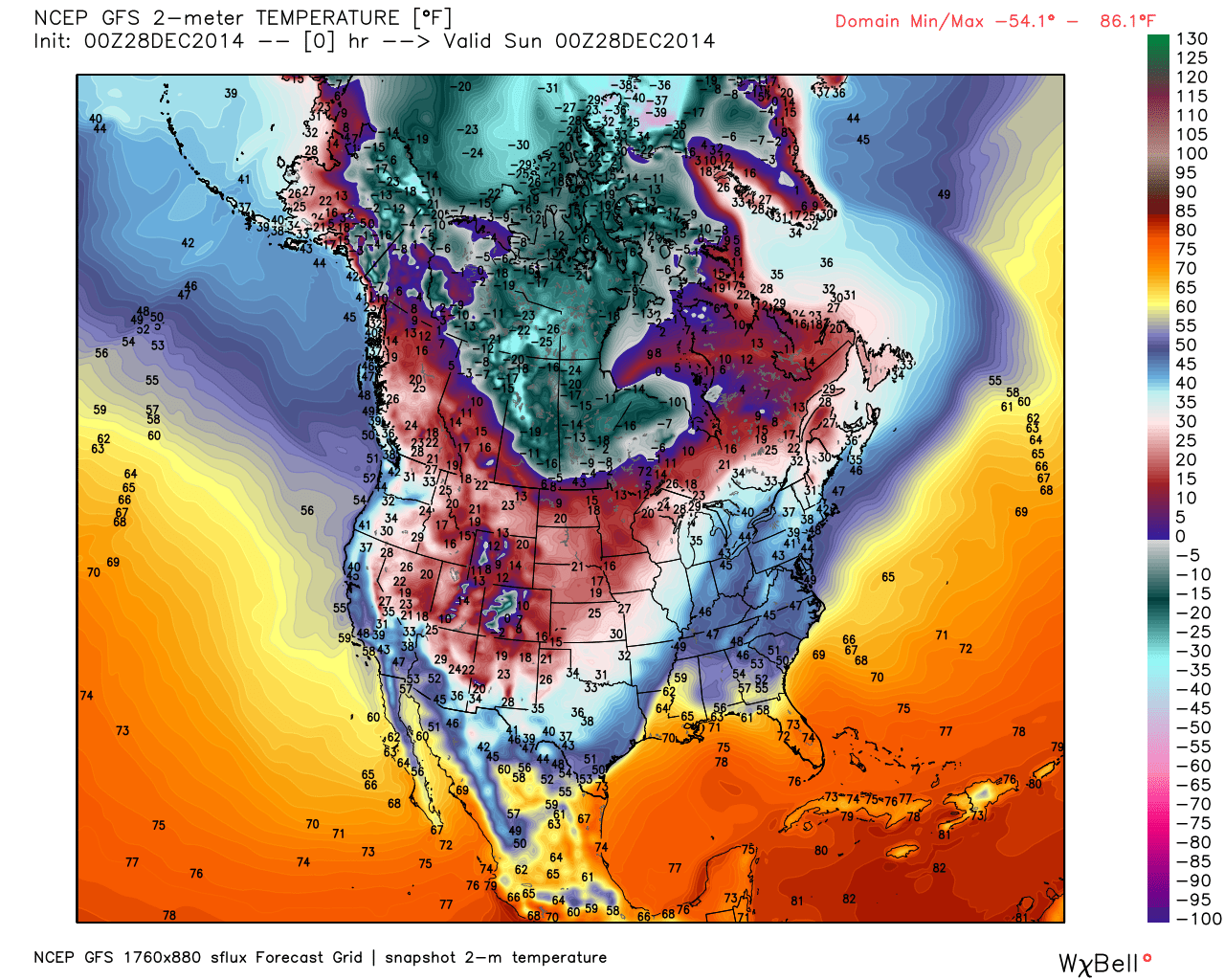
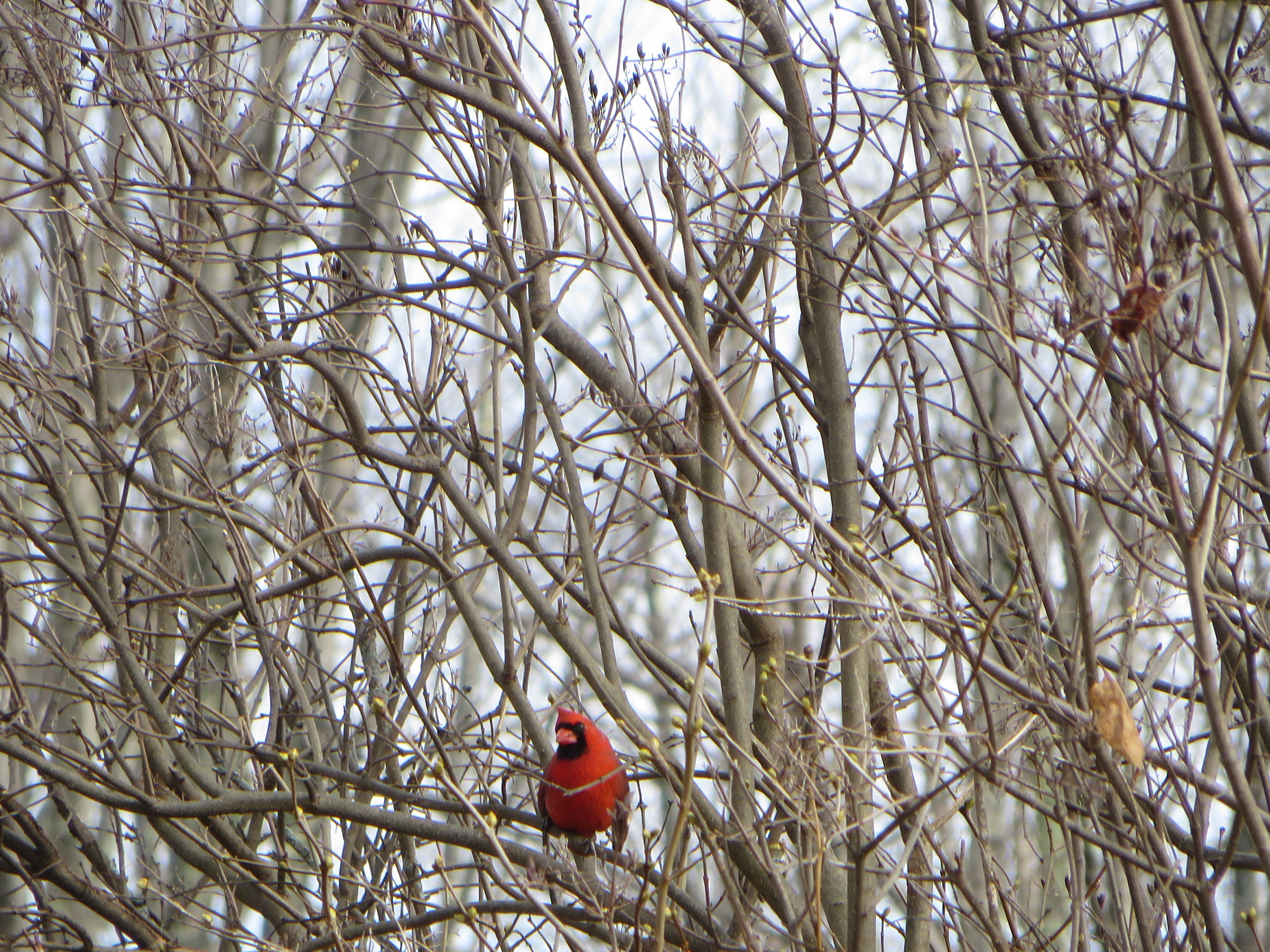
As I get older I seem to look forward to winter less. I’m not as hot-blooded, and where I once threw snowballs without gloves and saw my hands glow a ruddy red, my hands now turn blue at the slightest excuse. Not that I still don’t hope for a white Christmas; I just hope we get around an inch at daybreak, and it melts away by Christmas afternoon.

It was said, back when I was young, that the Indians called an old man “one who has seen many winters.” I’m not sure how true that statement is, in terms of history, but it says something about how winters tax a man.  Like the taxes of a greedy government, winters sap you, and take so much out of you that you get tired of paying. However, for the poor, there is no escape to Florida, and therefore the mind has to adopt some sort of strategy, in order to endure the coming insult to our physical forms. After all, if you believe in evolution, we are jungle monkeys, at home in a Garden of Eden, and not upon tundra.

Even if you don’t believe in evolution, it has been a long, long time since we dwelt in Eden. Even if you don’t believe in evolution, perhaps we have been bred like dogs into certain breeds. Even if you don’t believe in evolution, it seems obvious that people to the north have whiter skin than people to the south, as sunshine is necessary, to produce Vitamin D,  but you can get too much of a good thing, in which case sunshine causes skin cancer.  God does amazing things to protect His children, and white skin allows people to get enough vitamin D where sunshine is low and weak, while dark skin prevents skin cancer when the sun is high, hot, and burns.

I have started to wonder if there are some other traits which have been imparted to northern people, that help them deal with winter. Because I run a Childcare, it seemed a good place to study the way the young react to the change in seasons, to see if they have any behaviors that seem northern in nature.

My study seemed especially insightful because modern children live lives so insulated from the outdoors, as do their parents. Parents chose our Childcare because they believe the outdoors is good, in theory; in actual fact they work indoors and only a few get out for hikes on the weekends. Therefore the children, who unknowingly were about to become subjects of my highly scientific study, were pure, and not corrupted by earlier experience of the outdoors. I could see responses that were fresh, and showed primal instincts.

One thing that became clear was that “shelter” became abruptly more important, as days swiftly grew shorter.

Not that children don’t build structures in the summer, but these are largely “forts”, and are built for warfare. “Warfare?” you ask? Yes, sad to say, but children do have a less than harmonious side, and build all sorts of forts that display sexism (“girls only” and “boys only”) and ageism (“big-kids-only” and “little-kids-only”) and even status-ism (“cool-crowd-only” and “uncool-crowd-only”), and then they steal sticks from each others forts and then rage about the robberies. You’d be amazed by how much time I have to spend overseeing the ownership of sticks. We have no toy guns at our Childcare, but over and over I hear either, “He keeps aiming his stick at me!” or “He stole my stick!”  Sometimes I can muster the wisdom of Solomon, “I’ll tell you what I’ll do; I’ll break the stick in two and give you each half,” but other times the only escape is to get away from the forts altogether, by going on a hike.

It was on hikes I first noticed the sudden interest in shelter. During summer rains I have a hard time getting children to bother with raincoats, and often wind up carrying raincoats they shed, as they delight in becoming drenched. However, as the sun sank lower in the southern sky at noon, the rain-clouds darkened, and suddenly the children wanted not only raincoats, but umbrellas, though the wind was from the south and rain wasn’t all that colder. As I happened to have seven umbrellas, I handed them out to the children, taking notes, for my highly scientific study, of this sudden interest in shelter.

Shelter 1 FullSizeRender

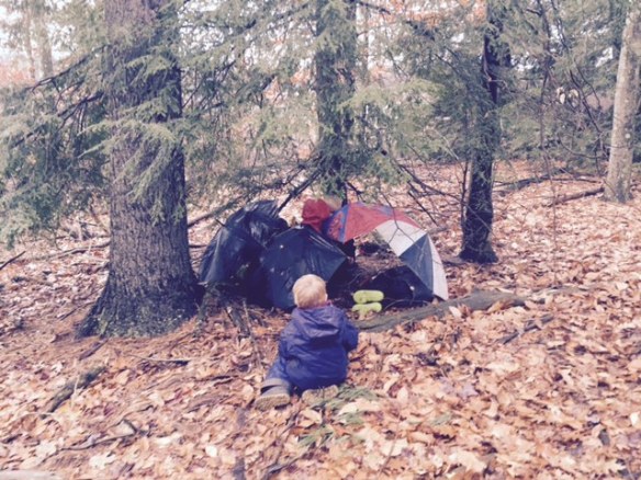
The rain then stopped, and you might think I’d then wind up carrying seven umbrellas. In actual fact I only wound up carrying five, because some sort of greed kicked in, and two umbrellas became some sort of status symbol. I had to break up fights, and teach “sharing”, and have them “take turns”. However it was when we entered the forest and were beneath the shelter of trees that I got a surprise. They all demanded their umbrellas back. It wasn’t because the rain had started again. It was because they wanted to build a shelter. I took a picture, for my highly scientific study.

Shelter 2 FullSizeRender

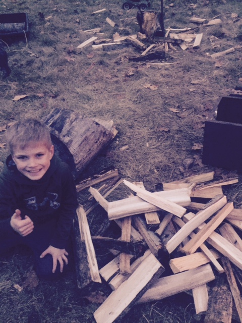
When we returned from our hike and I collected the umbrellas, (slightly the worse for wear), I became aware of a second attribute seen in northern children, which seems unlikely and only was revealed due to a mistake I made when I first opened the Childcare ten years ago. Back then I thought kids might be interested in old fashioned stuff, which is basically Neanderthal by modern standards: I showed them how to split wood with an ax and lay a campfire.

Big mistake. There is nothing more exhausting than having to oversee children swinging axes, and children by a campfire is nearly as bad. However the activity was incredibly popular, and the older children infected the younger with the desire to wave axes and feed fires. Any hope the interest would die away as the older children moved on from Childcare to more formal schooling, and I ceased to actively promote the activity, was dashed by the children who remembered the year before, and pleaded, “Please, please, Puh-leese can we chop wood and have a fire?”

To some degree it is gratifying to watch a boy grow from barely being able to lift an ax to becoming proficient at reducing a fat log to kindling. At times I think the Neanderthal were on to something. Rather than Ritalin they gave boys axes, and rather than drugged faces they saw faces that shone with pride:

Shelter 3 FullSizeRender

But there is no getting around the fact I have to work pretty hard to teach a boy to split wood with a Neanderthal implement. Some might say it is easier to just send them off to fight Arabs, so we can be lazy and just spin the dial of a thermostat, heating our homes with Arab oil. Never mind that the back yards of some homes are forests full of dead trees and fallen wood, (which is great for the local populations of woodpeckers, but represents an increasing forest fire danger during droughts).

Never mind that. That is a loaded subject for some future post. Instead let us face the fire-danger wood-stoves present us with. The poorer people in this area are still Neanderthal, and still burn wood, and fires do escape stoves, and houses do burn down, which means the fire department needs to educate children about what to do in a fire.

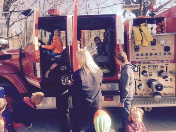
One thing that upsets children is that a fully dressed fireman looks, and even sounds, like the evil Darth Vader of Star Wars movies. Firemen entering homes to save children have seen them take one look at their rescuer and run the other way. Therefore they come to my Childcare and show that they are smiling, nice people,  before they dress in scary-looking gear. Even though the children have seen the nice people put the gear on, they still tend to be scared once it is on.

Shelter 4 FullSizeRender 
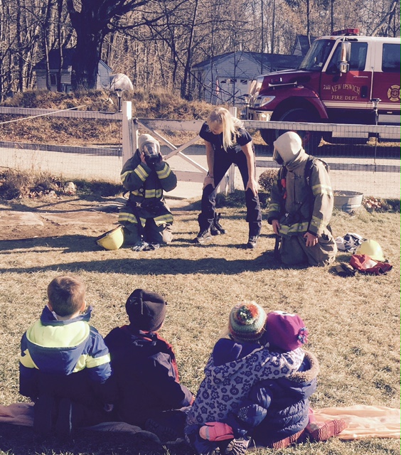
To be accurate, as a reporter, I should add it is somewhat amazing I was even able to take the above picture, because the Darth Vader appearance of the firemen completely freaked-out a two-year-old, who was wailing in my arms. He wouldn’t let go, even when they took off the costumes and let the other children experience the sublime joy of sitting in a firetruck.

Shelter 5 FullSizeRender

Perhaps what the two-year-old was trying to tell me was that, no matter how amazingly nice firemen and fire-women may be, something scary is involved in the subject.

For that matter, something scary is involved in the subject of fire, and even in the subject of winter. Both freezing and burning are scary.

Children are not as stupid as some seem to believe. (For that matter, neither are adults.) It is futile to gloss over reality with an insipid belief we can be spared a very real thing: Old Man Winter is coming, and will turn turf into tundra, and unless you befriend the dangerous realities of fuel and fire, you will die.

Some seem to believe children should be buffered in over-heated classrooms, with nature only seen on video screens, and spared knowing of the bitter winds that bluster and buffet outside. It likely a heresy for me to say this, but I think such mollycoddling harms, for the results of my highly scientific study suggests children are happier, healthier, and smarter when allowed to learn what their northern, Neanderthal genes already yearn to learn about, which is not the subjects of grammar, “social studies”, and algebra, but rather the subjects of shelter, fuel, and fire.

The sun is low at noon, and by four o’clock
The west is aflame: the sun is a fire
In the boughs of pines that bitter winds rock,
And their trunks send long shadows across mire
Turned to stone tundra. It’s north we’re heading.
The farm pond skims with ice too thin to tread;
There is no skating, no snow for sledding;
But the west grows dark with approaching dread
And the children aren’t fools. They want a fire.
I have solar lights that cast blue firefly
Dimness, but they want orange to inspire
Dancing and warm mirth. Should I not try
To teach fire is something other than danger?
Winter’s too cold when fire’s a stranger.

UNPRECEDENTED!!! THE GROUNDHOG DIED!

Sad news has come from Canada. The cute and cuddly woodchuck “Winnipeg Willow” expired early on Saturday, January 30. Groundhog Day willow-groundhog

Unconfirmed reports state that Winnipeg Willow was seen drinking heavily on Friday night, and was heard screaming, “I can’t take it any more, I tell you! I’m vermin! I break horses legs with my holes, and can demolish an entire vegetable garden’s worth of spring seedlings in one night! My Momma didn’t raise me to be no teddy bear! But for five years I’ve had to put up with this @%$#&^%,  @#(**&  @#$$^%. I can’t take it! Don’t they know the only time a woodchuck is ever good is in a stew?”

The caretaker could not be reached for comment.

The news that the groundhog died apparently set off panic in Canada’s large community of Global  Warming Alarmists, who have stampeded to the southern border, making it hard for our reporter to get north for interviews (and to see if they wanted the yummy woodchuck meat, which is hard to come by in February.)

Groundhog 2 traffic-jam

http://www.cbc.ca/news/canada/manitoba/winnipeg-willow-dies-groundhog-day-1.3426922

BREAKING NEWS

Government officials, speaking under conditions of anonymity, state there is no truth to the leaks that suggest Willow was driven to drink by government pressures that she only forecast warming winters, when she wanted to forecast six bad weeks coming after the current thaw. Copies of emails suggest Willow was offered a 100,000 carrot scientific grant to see no shadow, but the emails have since been erased and Willow’s laptop has mysteriously disappeared, asserted an anonymous source speaking at an undisclosed site to an under-educated reporter.

Further government statements from multitudinous leaks leaking under a guarantee of strict secrecy absolutely deny that Willow was assassinated, which is odd, because no one ever suggested that.

/sarc

ARCTIC SEA ICE —Hudson Bay’s Slow Thaw—

I focus on Hudson Bay for selfish reasons.  The faster it thaws the better, as far as I’m concerned. As long as it has ice floating around on it there is a chance for some unseasonable cold to come south and spoil my summer, down here in New Hampshire. In fact it happened just last week, when a summer storm swirled up across the great lakes.20150627 rad_ec_640x480Around the backside of that storm came north winds, drawing air down from Hudson Bay, and while the welcome rains began warm and summery, they gradually grew more and more chilly, until we experienced a daylight with temperatures never rising above 53° (12° Celsius) and a driving mist. That doesn’t count as summer, in my book.

Other people look at sea ice for political reasons, and focus on this graph, which shows how swiftly the ice is melting. As you can see, two thirds of the ice melts every year. Almost always all the ice in Hudson Bay melts.DMI2 0704 icecover_current_newIf you are politically aligned with the Global Warming theory, you want the ice to be low, and to beat the lowest green line on the graph. In fact, you need it to, because otherwise your theory is humbug and you have to give all the money you took to combat-Global-Warming-with back to the people you stole taxed it from.

The theory, in case you haven’t heard it, states that white ice at the Pole reflects sunlight and keeps the earth cool, but dark oceans without ice will absorb the sunlight and the earth will heat up, and indeed “get a fever”. If this theory was correct, the low levels of ice in 2012 would have resulted in warmer waters and even less ice in 2013. As you can see, that didn’t happen, nor did it happen in 2014. Rather than conceding their theory is humbug, the Alarmists say, “Just wait until next year!”

So here we are, in July of the next year, and once again the ice is failing to prove the theory. This is getting rather monotonous, but there are still some Alarmists who go “Ah ha! Ah ha!” if the graph ticks down, and cheer wildly if there is a steep fall. It is all much ado about nothing, as far as I’m concerned, as in many cases the ice is going to be gone by September in any case, and then grow back in December, but people seem to regard the graph as a sort of sporting event.

Often I see a major misconception displayed by people who don’t know their ice. They think the north Pole is an icecap, when it is an ocean. It is the Arctic Ocean, and the ice never sits still. In other posts we have followed buoys day by day as they’ve traveled over a thousand miles. One began near the North Pole and wound up on the north Coast of Iceland. One began on the north coast of the Canadian Archipelago, squeezed down into Nares Strait, traveled down the northwest coast of Greenland and then down Baffin Bay and wound up vanishing off the coast of Labrador. O-buoy 9, which we are currently following, began on the Eurasian side of the Pole, crossed near the Pole, and now is scooting along the north coast of Greenland on its way to Fram Strait. Nor is this a new phenomenon. During the Cold War in the 1950’s military bases floated around on “ice islands”,  and in 1893 the arctic explorer Nansen attempted to drift across the Pole in a boat frozen into the ice called the “Fram”.

Hud 5 800px-PSM_V57_D434_Map_showing_the_regions_traversed_by_nansen

Another misconception is that this motion only occurs during the summer, and that things are frozen fast in the winter. Even in the depths of winter the ice is in motion, and areas of open water can appear, many miles across, even when temperatures are -40°. When winds roar off cold tundra, the areas of open water along the shore, formed as the sea-ice is shoved out to sea, are called polynyas, and in places occur with regularity, for example along the shores of the Laptev Sea, or at the top of Baffin Bay. In such places the ice can be quite thin when spring comes, as it has had to reform at the very end of the winter, and it may be swift to melt. In other places, where all the ice has been blown, for example along the coast of the Canadian Archipelago and northern Greenland, the ice can pile up into a towering jumble.

When we look at the ice we see it terms of thickness, and concentration. The map below shows concentration today.Hud 3 arcticicennowcastWhat is notable in the above map is the lack of open water in places where you might expect it on July 4, notably the Laptev Sea, Baffin Bay, and Hudson Bay. I’m focusing on Hudson Bay for the reason I gave earlier.

Hudson Bay started June with less ice than recent years, which made Alarmists happy, but now it has more ice than recent years, which likely has Alarmists glum.

Hud 2  r10_hudson_bay_ts1

It has me glum because, as long as there is ice floating on that bay, it can generate sub-freezing temperatures under clear skies during the short nights. (Pink is below freezing in the map below; ignore the glitch that makes that mess along the left margin). Hud 1 cmc_t2m_arctic_2As soon as Hudson Bay is ice-free, it will stop creating that threat to my north, and my tomato plants will breathe a sigh of relief. In the meantime, I keep an eye on the bay using the Canadian Ice Service map.Hud 4 CMMBCTCA

What is odd to some viewers is that the ice melted in the cold north part of the Bay before it melted in the warm south. This occurred because the wind howled down from the northwest a lot last winter, forming polynyas along the northwest coast, and cramming all the ice down to the southeast. Therefore one can see that not even in an enclosed bay does the ice sit still, in the arctic.

I’ll be watching the ice carefully because on some rare years it fails to melt away completely. That would be a bad start to our winter, as by September the bay is usually warm enough to warm the arctic blasts coming down towards us. If it starts partly frozen and freezes early, we could have January cold waves in December.

So you see, when I watch the ice there is a practical side to it. I’m not trying to make some political point, and not tempted to make things sound more dramatic than they are in order to gain more attention and money.

This brings me to why I prefer the Canadian Ice Service, (within limits.)  Other ways of “seeing” the extent of the ice have some major flaws, and show water as “ice free” when it most definitely isn’t.  A major flaw involves using microwave imagery from space, the problem being a melt-water pool may be seen as open water.

This problem was highlighted in a somewhat humorous way by polar bear researchers who pestered poor bears by drugging them and attaching GPS thingies behind their ears, so they could be tracked. The bears do 67% of their hunting and eating between the time the arctic sun comes up and the time the ice melts away, which in Hudson Bay is between April 1 and July 1, usually. Then they waddle ashore fat and happy, and then do 33% of the rest of their eating in remaining 75% of the year. However, as the bears were tracked, it was noted that they spent a lot of time in areas that some maps showed were “ice-free”. The maps below (From polarbearscience.com ) show the locations of bears last year, with some in “ice-free” waters.Hud 6 hudson-bay-breakup-2014-pb-tracking_30-june-vs-8-july_pbi

This put the scientists in an embarrassing situation. While bears can swim over 700 miles if they have to, they don’t do so for sport, and therefore had to be moving from berg to berg hunting seals in waters the maps showed were ice-free.  Scientists blushed, as they had gained funds by stressing how stressed the bears were by ice-free waters, that made it impossible for them to hunt. Now the scientists were the stressed ones, because the bears were hunting where scientists said they couldn’t. Obviously the bears needed to go back to school. What is funny is how slow the scientists have been to mention this discovery to the people funding them. (I suppose some discoveries are not entirely welcome; who is going to fund the endangered polar bears if you discover they are fat and happy and not endangered?) (Of course, the discovery of hidden ice up there may endanger my tomatoes. Will no one fund those scientists for the sake of my endangered tomatoes? Please do, or we may have endangered scientists.)

As for me, I’m glad I only do this as a hobby, and as a way of making a guess if next winter will start out cold or not.

THAW SPEAKS WITH FORKED TONGUE

This is just an observation, because sometimes even a simpleton’s observation can trigger entire chains of thought in better minds.

Europe’s weather has almost no effect on weather here in New Hampshire, as Europe is “down stream.” My interest is mostly in how Europe’s weather is effecting the weather north of Scandinavia in Barents Sea, due to my hobby of studying sea-ice. However I did live in Scotland for nearly a year, so perhaps I have a few fond memories that increase my interest, and cause me to focus more than I would if I were sensible.

One thing I’ve focused on is how our warm air masses head across the Atlantic, sometimes fueling huge gales and hardship, and sometimes arriving in Europe as benign  northern arms of the Azores high, begiling and enchanting northern lands with southern warmth.

Last winter North America was so cold much warmth was shunted off shore and headed north to aid Europe. It was like the good old days, when America could afford to be generous.  Europe hardly had a winter, so much mildness poured over it on southwest winds.  Now, however, perhaps America is bankrupt and shrunken, for even when we send our warmth northeast, it seems pirates rob the freighters of air before they get to  Europe.  Our promises are reduced to those made with a forked tongue.

I became aware of this keenly, quite recently, after I had decided the past cold spell had ended in Europe, and England was being rescued by warm west winds, but then read a blogger describe how the west winds held snow, at a rate of an inch an hour.  This was so utterly different from last year I sought a cause.

Of course, I can’t describe the cause in terms a scientist would think much of. However, as a layman, I can state there certainly is a thing-in-the-way. Something is causing the nice, mild flow of air we send to Europe to fork like a snake’s tongue. Where it flooded straight ahead last year, this year it either turns left towards the top of Greenland, or turns right to head through the Mediterranean, or, if plows straight ahead, gets occluded, in which case the warm air is to high up to do those on the ground much good.

Last year I described Siberian air as “the snout of Igor”.  This year it as if that snout has kept nosing west, then flinching back, but then nosing further west, before flinching back not-as-far.  It is a repetitive, progressively westward sort of snouting. It doesn’t take a nice, neat form, as a high pressure, though sometimes it builds a high pressure. Rather it is just a cold, sinister, east wind.

I’ll leave it to larger minds to fathom it all, and to study the differences between last year and this year, and explain it to fools like myself. I’ll just give you a series of UK Met maps,showing how the nice warm air we send to Sweden never gets there.

The first map shows that, while our last warm package may have been thwarted short of the coast of Norway, southeast of Iceland we have a total of four warm fronts, headed straight for Sweden to impress those Swedish babes. (Click maps to enlarge.)

UKMet 0106A 21404681

24 hours later we’ve only impressed the babes of Ireland.

UK Met 0106B 21406920

48 hours later we may be impressing the babes in Paris, but what the heck happened in Sweden? No sooner did we get there when a cold front boots us out! What kind of welcome is that. (Also note the sourse region for the west winds is not the Azores. It is the southern tip of Greenland. It may not be Siberian air, but it isn’t summery.)

At least we can look west. and see two more lows crossing the Atlantic, bringing reinforcements of mild air.

UK Met 0106C 21407544

After 72 hours we are wondering  “What the heck is going on?” The warm air that wooed Paris is now a shrunken warm sector by the Black Sea, and all the warmth of our first reinforcement is occluded aloft as it approaches Norway. (Please remember last year warm fronts surged right over Scandinavia with little trouble.) However at least we have our second reinforcement approaching Ireland.

UK Met 0106D 21408521

After 96 hours we are definitely discouraged. Though we did manage to again get a warm front into Paris, the Swedes are laughing at us, as we never get there. Furthermore, winds are turning north in the north of Sweden. Our rivals the Russians are coming!

UK Met 0106E 21411673

By 120 hours all our attempts to warm Europe are a shambles. A fragment of a warm sector is over the Black Sea, but all other warmth has been occluded and is aloft. The Atlantic air over Europe is not from the Azores, but from Baffin Bay and Greenland. And Siberian air is starting to swoop around the  north side of the low east of Finland.

How did that low get there, anyway? Last year lows charged up over Scandinavia and continued on, at least in part, along the Siberian coast, east all the way to the Bering Strait. This year they have no identity, and form and reform into a ill-defined shape that sags southeast, and allows Siberian cold to come west over the north side.

UK Met 0106F 21411683

Last year the maps always seemed to show southwest winds over Scandinavia. This years map shows winds swinging to the northeast.  An invisible shape is forking what was a straight flow.

That is my observation. You figure out the details.


SNOW IN ALGERIA (with update)(Winter of 2014-2015)

Algeria Snow 2210_algeria

I am always interested in snow and cold getting across the warm Mediterranean to North Africa, as my over-active imagination likes to create a blooming Sahara.

This is the second time in two years they’ve had the rare snows down there. I haven’t heard whether it snowed on the pyramids again, (which resulted in a wonderful hoax and Photoshopped picture, last year.)

Apparently there were reports of snowflakes in the air on the island of Malta, right out in the Mediterranean, which would have been a first. The Malta weather bureau couldn’t confirm it.

http://www.maltatoday.com.mt/news/world/47963/snow_blankets_sicily_and_northern_africa#.VKmin9LF_kc

This first Siberian blast is pretty much over.  The high pressure which had freezing east winds to its south side had milder west winds bringing Atlantic air east on its north side, and for a while it was warmer in Sweden than in Sicily.  Some good reports are in this post from Watts Up With That:

Snow in Palermo, Sicily

Here’s a brief video of snow in Palermo. For some reason pictures from this video which appeared around the web have vanished. Likely it is some copyright fuss.

http://www.euronews.com/2014/12/31/blanket-of-snow-and-icy-conditions-across-italy-for-new-year/

Even up in Scandinavia, where the milder Atlantic air came in from the west, it was cold enough to cause so much snow they had to plow the slopes to keep skiers from getting caught up in the workings of the lifts and ground into hamburger.

Norway ski plowing utviken_sn%C3%B8

http://www.firda.no/Dette_skisenteret_m__fjerne_sn_-5-15-15714.html

The mild air over Scandinavia brewed up a sizable gale up there, but now that gale is sliding east, and absorbing a lesser storm to its west, and it looks like that, behind the two storms, a northerly flow will come down over Europe tomorrow. What is interesting is that it is almost immediately followed by a southerly flow as the next Atlantic storm moves in from the west.

UK Met 0104A 21358040 UK Met 0104B 21360686 UK Met 0104C 21360964

These back and forth surges of air have been interesting to watch. The computer models can’t seem to handle them very well beyond a few days into the future, for some reason.

What I am  watching to see is if a pattern repeats. If it repeats the mild air will surge up towards the Pole, but then low pressure will collapse down into Siberia, and the north side of that low pressure will bring a new wave of Siberian air west into Europe. However that is a big “if.”

UPDATE —January 6—

Even as milder air has surged up towards northern Norway, and milder Atlantic air has brought above freezing temperatures nearly to the towns in 24-hour-darkness upon Svalbard, what is left of the last European Cold-wave has sagged south and now is bringing snow-warnings to the Holy Land, as Joe Bastardi noted on his blog at Weatherbell today:

Holy Land Snow Screen_Shot_2015_01_06_at_8_10_04_AM

If it does get above freezing in Svalbard, it will be warmer there, well north of the Arctic Circle,  than where Arabs ride camels under date palms.  That just shows you how amazingly topsy-turvy and loopy a “meridianal flow” can get, in Europe and western Asia.

By the way, before babes in Sweden send their muffs and mittens to Palestine, it should be noted that the Canadian model is showing another Siberian invasion hitting Scandinavia in around six days. (See my January 6 post on cross-polar-flow for more details.)


LOCAL VIEW —Brunt Bearing—

The Christmas break is about over, in terms of brutal weather. You can tell the north is up to no good when the isobars are straight north-south all the way from high pressure in the  the Canadian Rockies to low pressure east of Greenland.

20141229 satsfc

When these surges of cold come south you look for a storm to brew up, but the storm south of us looks like it is being swept right out to sea before the cold air can catch up to it, and turn it into a blizzard. There is too much of a gap between the first cool front, with polar air behind it, and the second that indicates the arrival of the truly arctic air.

20141229 rad_nat_640x480

It would be fine with me if all the storms stayed south of here, and we just saw the lakes freeze up and make for good skating.  The ski areas wouldn’t be happy, but maybe we could arrange for some flurries in the higher hills.

The problem is that, during some of these 1970’s-style winters, the arrival of the cold brings about huge surges of warm air back north. The winter of 1977-1978 springs to mind, with three blizzards, two in the east and one in Ohio. (Check out the end of the December 17 post for details of those storms.) https://sunriseswansong.wordpress.com/2014/12/17/local-view-to-snow-or-no/

Currently it looks like the surge of the warmth will occur across the Atlantic. As a cold high pressure settles down and brings a winter cold front as far south as north Africa, with cold, east winds on the south side of the high pressure, a rebound of milder air will rush up around the top of the high pressure, and the UK Met is showing a New Year’s Day where it might be milder in Sweden than in Sicily.  (We’ll see about that.)

20141229 21210834

I’m not sure why I’m looking at Europe. I should pay attention to what is in front of my nose, which is a opportunity created by an open winter. The last of the Thanksgiving snowstorm has melted away, and the forest floor has gone from white snows to being leafy and brown.

I could use a spell with the woods staying snow-free, to get a bit of firewood out. We’ve used up more than I planned on, with the kids home and a baby in the house. Also I don’t need the work of snow-removal, for I’m feeling in the mood to write outside of this blog, and it is making me restless. If I disappear it will be because I’ve taken a time machine back to the early 1970’s, as that is what I want to write about.

Cabin fever, though the woods are snowless.
Cabin fever, though the days are fair.
Cabin fever, and it shows I grow less
Wise with time. Age makes me unaware.
 
Now my cabin is my flinching body,
That cringes from invigorating gales,
But my spirit still is hip, wild and gaudy
And longs to grip ropes and set winter sails.
 
“Let me out of here!” My restless spirit
Paces past eye-windows of discontent.
My songs creak and quaver, and I can hear it
And hush, and wonder where a lifetime went.
 
“What’s the point?” The answer is grim and clear.
Beethoven wrote best when he couldn’t hear.

ARCTIC SEA-ICE RECOVERY –Sneak Attack onto Europe–

The last two weeks has been interesting to watch, though the growth and extent of the ice is fairly normal. Here are the extent maps from December 12 (to the left) and December 27 (to the right).

DMI2 1212 arcticicennowcastDMI2 1227B arcticicennowcast

As Hudson Bay and the Bering Strait have frozen up, most of the growth in ice from now on has little to do with the Arctic. You could almost call it cosmetic. It will be occurring in the Pacific, or the mouth of the Saint Lawrence River, or the Baltic Sea, and therefore will be fleeting, and have little to do with the Arctic Sea itself, which is what all the fuss is about in the summer.

I tend to watch the arctic ice-thickness maps, which can give you an idea where the ice is moving. It moves far more than many imagine. For example, hundreds of square miles of thicker ice that had been lodged north of Franz Josef Land was shifted west by storms and crashed into the north coast of Svalbard, over the past month. This created a sort of polynya of open water where the ice had been by Franz Josef Land, which swiftly froze over and became thin ice.

DMI2 1227B arcticictnowcast

If this large body of ice continued to move west it might be flushed south through Fram Strait, which could create a situation much like occurred in 2007, when the thick ice was flushed south of the Pole, leaving the Pole with a thin skim of ice as summer approached, and, because the thin ice melted easily, the people who assume the icecap is in a “Death Spiral” had something to hype. (The main difference between now and 2007 is that there is much more thick ice north of Canada now.)

Watching the thickness maps allows you to see where the ice is piling up and where it is thinning, and gives you a rough idea on the total volume of ice up there.  There are many interesting processes occurring that you seldom read about.  For example, the same strong winds that blew the ice away from Franz Josef Land also blew the ice away from the south coast of the Kara Sea, and you can see that ice as thin blue lines of thicker ice now out in the middle of the Kara Sea.

Ice really piles up on the west coast of Baffin Bay, and grinds southeast along that coast and then along the coast of Labrador towards the North Atlantic. Ice also can pile up on the south and east coast of Hudson Bay, while the north coast can see polnyas form, so that even though the north was the first to freeze and the south was the last to freeze, by spring the south has thicker ice than the north. Lastly, ice can be seen piling up just west of the Bering Strait on the north coast of Russia; last year this ice was piled up 20 feet thick there by spring.

Watching the thickness maps brings many surprises, especially when storms wrack the ice. In the dead of winter, with temperatures at -40°, I have seen leads of open water form that are scores of miles across and hundreds of miles across. The open water freezes to thin ice almost immediately, but sometimes you can still see signs of that thinner ice months later. In a similar manner storms had a lot to do with the build up of thicker ice north of Canada.

At times the thick ice can crumble and be spread out into open waters, and mess up all sorts of neat calculations in the process. Where a cold current often sinks when it meets a warmer current, and more saline waters want to sink beneath more brackish waters, it is physically impossible for the ice to sink, and it bobs merrily onwards on top, often significantly chilling both the temperatures of the surface waters and the air, until it melts away. Therefore a strong wind transporting ice south can alter temperature maps with startling speed.

I imagine there are times when such alterations make a difference in the forecasts generated by computer models. They may even explain why the models utterly failed to foresee the cold that slumped south onto Europe recently. Just as it only takes a single pebble to start an avalanche, a single miscalculation can mess up a computer model.

Although the models did not see the cold coming, Joseph D’Aleo and Joe Bastardi on their blogs at the Weatherbell site did say we should be on guard for cold waves to hit Europe, as the autumnal patterns were similar to years in the past that saw cold waves hit Europe. They didn’t explain how it was going to happen in a step-by-step way, so I watched very carefully to see if I could see the steps as they occurred.

Back on December 12 we were seeing south winds bring warm air flooding north over Scandinavia, as the Atlantic storms veered north towards the Pole. A lot of Barents Sea was above freezing. Cold air was exiting the Arctic down the east coast of Greenland.

DMI2 1212 mslp_latest.big DMI2 1212 temp_latest.big


This pattern continued on December 14

DMI2 1214 mslp_latest.big DMI2 1214 temp_latest.big


And peaked around December 17

DMI2 1217 mslp_latest.big DMI2 1217 temp_latest.big

By December 19 the storms were no longer heading up to the Pole, but were moving east along the north coast of Russia. Barents Sea was cooling down, and to the east of the storm cold Siberian air was drawn up over the Arctic Sea and then dragged back west, and the milder Atlantic air lost its influence over the Pole.

DMI2 1219 mslp_latest.big DMI2 1219B temp_latest.big


By December 21 the new storm track had the east winds to its north starting to drag cold air back towards Scandinavia. The following Atlantic Gale didn’t bring such a flood of warmth north.

DMI2 1221B mslp_latest.big DMI2 1221B temp_latest.big


By December 24 the new storm track had penetrated weakly to the Pacific side of the Pole, and chilled Pacific air was being drawn over the Pole, but was too cold to warm the Pole much, and the cold air over the Pole was heading south to Scandinavia, and below freezing temperatures seeped down the coast of Norway.

DMI2 1224B mslp_latest.big DMI2 1224B temp_latest.big


By the 26th of December the cold was building over the Pole, and the strongest low pressure was east of Scandinavia, transporting Siberian air back west over its top towards a Barents Sea that was now far colder, especially to its north. The Pole was as cold as it ever gets, except on rare occasions, and the weight of that dense air was spreading out, including down towards Europe.

DMI2 1226B mslp_latest.big DMI2 1226B temp_latest.big


Today we see the following North Atlantic low is weak, without a surge of southerly winds, and the isobars hint of a discharge straight from the Pole to Scandinavia and areas further south.

DMI2 1227 mslp_latest.big DMI2 1227 temp_latest.big

This afternoon’s map shows the weak low bringing snow to Britain and the cold continuing to press south over Europe.

DMI2 1227B mslp_latest.big DMI2 1227B temp_latest.big

The computer models didn’t see this cold coming, even a few days ago, but now much of western Europe is below normal. As this cold continues to press south it is likely create elongated high pressure west to east. There may be a warm-up over Scandinavia as winds turn west to the north of the high pressure, but east winds to the south of the cold high pressure will bring very cold Siberian air further and further towards the Mediterranean, and a southern storm track will bring snows to Italy and perhaps even the north coast of Africa, before the cold is moderated.

DMI2 1227B gfs_t2m_anom_eur_1


However I have no business talking about Africa in a post about the Arctic, so I’ll just show the graph of temperatures north of 80 degrees latitude, which informs us the arctic is loaded with midwinter cold, and has plenty to spare.

DMI2 1227B meanT_2014

Besides dumping cold down on Europe, some is being dumped south into Canada and the western USA.  The thing to remember is that not only the Pole creates cold, but all areas of Tundra and Taiga generate cold as well, during these shortest of days. Better look for where you left your mittens.

DMI2 1227B gfs_t2m_noram_1

(These maps are created by Dr. Ryan Maue at the Weatherbell site.)


LOCAL VIEW —Christmas Bluebirds—

We are experiencing a truly kindly spell of late December weather, if you are an old coot like me, and have grown less fond of cold with time.

Not that I can’t remember being young and hot, and walking with a girl I was trying not to fall in love with, (and failing), and being warm through and through, though it was so cold the snow on the road squeaked as we walked over it. Also I can remember being desperate for snow, for I was running a lunch-counter at a cross-country ski area. However those are memories, and the reality is the present, and the Christmas present was mildness for an old coot, this year

What was really remarkable was a finger of warmth that reached the tops of the hills where I lived, but not the valleys. Indeed it was 43° atop Mount Washington, at 6000 feet, and only 40° at sea-level at the coast at Portsmouth. It was 39° in the Merrimack River Valley at Manchester 40 miles to our east, and 38° close to the Connecticut River in Keene 40 miles to our west, while here temperatures spiked up to near 60°. (57° in Jaffrey, 7 miles to our west.)

You can dimly see the finger of warmth in this temperature map, poking up into south-central New Hampshire (and also all the way north to Burlington, Vermont):

Xmas rtma_tmp2m_neus__1_(2)

On Christmas morning the sun came out and the breeze felt like April’s. Because we had the stoves going before the warmth came north, it was actually hot in the old house. I stepped out onto the porch and instantly remembered a Christmas back in my youth (1965?) when it was so mild I was running around outside flying a new toy helicopter barefoot.  I dedcided to stay outside to enjoy the mildness, figuring it wouldn’t last, as a front had come through to bring us our sunshine and clearing.

Temperatures did drop a little, but not much, and I could do my chores without gloves or a jacket.  My middle son was out with bird-watching gear, and announced by cell phone that a small gang of bluebirds, and a male and female cardinal, were by the house. I hurried, but didn’t see them, yet could hear them off in the distance, which seemed very evocative and symbolic of something just beyond my ken. (My son’s pictures:)

IMG_1085

IMG_1087

There was something so summery about bluebirds and cardinals being about on Christmas morning that I decided it must be my Christmas miracle this year, and a auspicious sign.

Then I sat back to wait for the cold to return, as it surely must. A warm wave in the winter is like the water drawing down on a beach; you know the water draws back further for the bigger waves. However though the cold has rushed down to chill western cities like Denver, it is taking its time coming east: (The first map shows our Christmas storm passing well north, with us on the southern mild side, and the second map shows two days later, with the east still spared the arctic air plunging into the west.) (Click to enlarge.)

20141225 satsfc

20141227 satsfc

The radar map shows snow along the battle lines between the cold west and the warm east:

20141227rad_nat_640x480

This battle line could brew up some big storms, as it works its way east, before the cold air eventually engulfs the entire USA. However for the moment we get a pause, a time of peace. The wind has died and the winter sun shines. Bluebirds are about. Obviously it is time for a sonnet.

I awoke to how wonderfully fashioned
Is a winter day, though the low sun is weak.
 
Faintly flavored, as when tea is rationed
And one sips a thin cup, one should not speak
Or one may miss the taste.   The breathless air
Is hushed; the sole birdsong is over a near
Hilltop, and is the scratchy cry of a rare
Christmas bluebird: Very faint; very clear.
 
I tell my noisy brain to be quiet.
I’m tired of its racket, and how it squints
At silence like bats in sunshine.
 
                                                    “Try it,”
Speaks the silence. “See My fingerprints
On every bough; with each breath you draw
See it takes no thought to wander in My awe.”

LOCAL VIEW —To Snow or No (with “santabomb” update)

A slug of rain moved up over us this morning, with just a bit of freezing on cold pavements, though the temperatures were above freezing at 36. I suppose the stones remembered the cold. The rain swiftly swept north and is gone, and now we are seeing a gray sun, with temperatures pushing 40. I suppose this is the long-awaited “warm-up.”

20141217A rad_ne_640x480_01 20141217B rad_ne_640x480_12

The rain-snow line has been pushed well to the north, but I am going to call this “Winter Storm #10” all the same. (We had some icy pavement, after all.) (I’ll never match the 26 winter storms of the 1600’s if I don’t cheat a little.)  Also a little snow may be swept around the backside, and give us a backlash tomorrow.

The map shows the warm front never made it here. It zipped up into an occlusion, and a weak coastal low has formed where the zipper is zipping, and the cold front separates from the warm front.  It seems that nearly the entire mild air-mass, full of Chinook kindness, was lifted before it got east. We got gypped. It all passed over head, as down on the ground we got a case of the shivers. (Click maps to clarify and enlarge)

20141217 satsfc 20141217B satsfc

That coastal low will likely blow up into a gale up over the Canadian Maritimes, and we will get north winds and some moderated arctic air. Somehow the cold always seems to manage to sneak down our way. Here’s the latest temperature map: (Click and then click again to fully enlarge.)

20141217B gfs_t2m_noram_1

Besides the chill hanging tough over New Hampshire, the map shows some grey coloring south of Hudson Bay, indicative of temperatures dipping below zero Fahrenheit ( -18 Celsius). That is some home-brewed Canadian cold that was prepared for us during the long nights the air sat over the snow-covered Canadian prairies.  When nights are at their shortest Canadians don’t need to import air from Siberia to freeze our socks off.  The irony is that where the subzero air now sits is the exact location where the friendly Chinook air lay, last week. It seemed so sure to sweep east and warm us.

I’ve been doing a lot of thinking about what happens to the warm air when it is occluded upwards. What happens to the heat it holds? There is a surprising amount of argument about whether it is radiated to outer space or not.

Another thing that kept the warm air from reaching us was all the snow-cover it had to melt away, as it came east.  It takes a lot of heat top melt snow, as the available heat turns into latent heat as water goes through the phase changes from solid to liquid, and from liquid to gas. (The opposite occurs when the phase changes reverse. A storm actually releases a lot of heat as vapor turns to liquid and liquid to snow.)

The snow-cover was at record levels at the end of November, and had advanced down to Texas, but the “warm-up” chased it north to Canada by December 13:

Snowcover20141213  ims2014347_usa

It has made a comeback behind Storm #10:

Snowcover 20141216 ims2014350_usa

You can see the snow is hanging stubborn, in New Hampshire, but it is not the pretty snow you see in Christmas cards. It is inferior, dingy stuff, with patches of bare ground showing on the south slopes. We could do with a touch-up, though preferably not until Christmas Eve.

I am going to add to this post later, as there is a lot of gossip about a storm this weekend, but I have chores to do before I can delve into that.

UPDATE  —“Santabomb” storm?—

As usual Weatherbell and “Whats Up With That” have beaten me to the punch, as Ryan Maue has tweeted the news about various Christmas blizzards the models are seeing.   The news can be read at http://wattsupwiththat.com/2014/12/17/santabomb-winter-storm-predicted-for-northeastern-u-s-at-christmas/#comment-1816610

The GFS computer was cranking out a 956 mb low over the Great Lakes: (Click to clarify and enlarge.)

Santabomb 958mb_low-xmas-day

First, this is a modeled storm, and models change their so-called “minds”, especially about events a week away.

Second, some sort of big storm is likely, as the very cold air returns and runs into the “warm-up” air in place over the USA.  The question is, where they will form and where they will move. In the winter of 1978 there were three big storms, two of which gave blizzards to New England, and which sandwiched a warm storm that sank my shack on the coast of Maine.

Here are some comments from the post over at WUWT:

  • Right. For New England there were actually three storms:

    1) In January a storm brought a record 24 hour snowfall to Boston and the east coast. I parked my VW Rabbit in a snow bank while I cleared the driveway and got snow on the external timing belt making it slip and the engine have zero compression. I figured out how to fix it the next day. This storm was poorly forecast by models.

    2) At the end of January, the midwest storm brought a record low air pressure to Cleveland, and quite a bit of rain to New York, Boston, etc. This is called the Blizzard of ’78 or the “Great White Hurricane” in Indiana, Michigan, and Ohio and well deserves both titles.

    3) Feb 6th brought another record 24 hour snowfall, winds that nearly blew my VW Rabbit off I 495, massive storm surges that destroyed hundreds of homes and killed dozens of people. It is known as the Blizzard of ’78 in New England states and well deserves that title. This storm was extremely well forecasted by the models, but between the poor job for the first storm and big problem of snow starting around 1100, everyone was at school and work, leading to massive mayhem trying to get home. While several of its records have been broken, it remains the benchmark that all other storms are compared against.

    I had the most awesome, impossible to duplicate drive home that night. Seehttp://wermenh.com/blizz78.html and its companion.

    Storm started Monday, this was Wednesday:http://wermenh.com/images/bliz78_int.jpg

    As Vic Werme states, the Cleaveland 1978 Superbomb was a warm storm in New England, between two far worse New England blizzards. It had the effect of turning the street-side snowbanks, leftover from the first blizzard, to slush, which then froze as hard as rock, and became a problem when the second blizzard arrived, as the snowbanks wouldn’t budge and the snow plowed by plows went up the rock-like banks and then tumbled back down into the streets behind the plows.

    Another effect of the warm storm was surprise flooding on the coast of Maine. The bays and inlets and harbors opened to the southeast, and the warm southeast wind was so strong it sort of dented your eyeballs. The tide kept right on rising after high tide.

    I was living on a shack on a dock on the Harraseeket River in South Freeport, and my idyllic little home was washed off the dock onto the mudflats. It is an amazing thing to watch your house go blub-blub-blub. I had a extensive collection of Jimi Hendrix albums which was ruined, for it turned out it was impossible to remove mudflat mud from the grooves of those old fashioned records. It seemed tragic at the time, however it was probably healthy to stop listening to that stuff all day. Every storm has a silver lining.

    In any case, as very cold air charges south into the USA we have our best chance for the sort of storms one talks about thirty or forty years later. This looks to be like one of those winters.

LOCAL VIEW —Thanksgiving storms—Calgary and Boston

Temperatures have risen overnight, as we get a brief breather from winter weather. As the cold high pressure sags out to sea to our south milder air is swung north on its west side and east over its top, and it is ten degrees warmer in Northern Vermont than down in Virginia. (41 degrees in Burlington versus 31 in Roanoke.) (+1 vs. -5 Celsius). The radar shows nothing but sprinkles of rain, and no northern snow. It is colder in Washington DC than up in New York and Boston.

20141123 satsfc

20141123 rad_ne_640x480

One breathes a sigh of relief in the mild, predawn darkness, but worry wonders where the cold has gone. It obviously is to our south, being warmed by southern landscapes and a the Atlantic’s Gulf Stream, as reinforcements must be gathered to our north up in Canada.

I like to look upstream to Calgary for hints about our future, and yesterday the Blogger Stewart Pid alerted me to a snow event they were seeing pop up on their long-range charts. So I look that way. (I hope this works)

MonNov 24      TueNov 25      WedNov 26    ThuNov 27        FriNov 28
Mainly sunny    Flurries           Snow              Mainly cloudy   Cloudy with sunny breaks
                                  
0°C                  -1°C                 -1°C                -6°C                 -8°C
 2-4 cm            ~20 cm            5-10 cm

That is the forecast for Fernie, up in the Rockies southwest of Calgary. The snow-event is not quite as big as it appeared in yesterday’s forecast, but a possible 34 cm of snow is nothing to ignore, and I can also see their mild weather will be ending.  The reinforcements of  arctic wolves will be heading south.

But will the howling wolves just head south to Texas in the west, as mildness surges north here in the east?  The models are showing a low heading up from the Gulf of Mexico towards the Great Lakes,  and that would seem to keep us on the warm side.  However, just as mild air can surge east over the top of a high, as it is doing this morning, cold air can surge under the bottom of a low, next week.  Too often I’ve watched mild air come towards New Hampshire, only to be lifted off the ground up into an occlusion aloft just before getting here, to count on any real warmth actually arriving.

Also, when a cold, arctic high pressure moves out over the Atlantic, as is happening today, it is sort of like the lid on a pressure cooker. The warm water wants to billow warmth up like a huge hot air balloon into the cold air, but the descending air in the high pressure keeps it clamped down.  It is as if the balloon is tethered down, and then, as the high pressure moves off shore, it is like the tether was chopped with an ax.  Abruptly the air rises and abruptly you have a storm off the coast, just in time for Thanksgiving.

So I go to the Weatherbell site to see what Dr. Ryan Maue’s maps say, and immediately see that, as usual, Joseph D’Aleo is miles ahead of me, and has already done all the work on his blog’s post.  He shows that GEM (Canadian) GFS (American) and ECMWF (European) all see the Thanksgiving storm, but have hugely  different solutions.

The GEM sees the storm slipping harmlessly out to sea.

Thanks 1 cmc_pr6_slp_t850_conus_23
The GFS model sees the storm just brushing us, with perhaps 2 inches of snow.
Thanks 2 gfs_pr3_slp_t850_conus_43
But the ECMWF?  Yikes!  We get clobbered.
Thanks 3 ecmwf_slp_precip_conus2_22(1)
(Click maps, or open them to a new tab, to clarify and enlarge them)
This morning a lazy American weatherman will just click onto the American model, and yawn, and forecast 2 inches of snow near the coast for Thanksgiving. The general public will make travel plans with no idea that the European model is forecasting Boston and New York getting buried by snow amounts like this: (Click to enlarge.)
Thanks 4 ecmwf_tsnow_boston_41(2)
Hopefully this forecast will shrink, as the forecast in Calgary seems to be starting to do. It is a “I’ll have to see it to believe it” forecast.  However, if I were making travel plans, I’d keep it in the back of my mind.