ARCTIC SEA ICE -Northabout Can’t Shortcut-(Updated Tuesday)

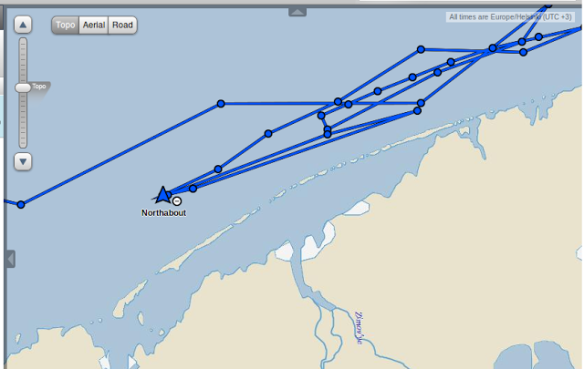
The good ship Northabout is past the New Siberian Islands and plowing east, using their engines, across the East Siberian Sea. They actually experienced an entire day without seeing sea-ice, for the first time since they left the open waters of the Kara Sea, before they came across a few unmapped bergs. The main threat they have faced, and conquered, has been engine troubles.

Northabout 20k Screen-Shot-2016-08-21-at-20.33.38-1024x680

If you look at the Bremen maps of recent years, you can see they might have formerly hoped to turn northeast and cut a corner, taking a sort of Great Circle route north of Wrangle Island.

Northabout 20a SeaIceMinimum2015-asi-AMSR2_small

No such luck this year:

Northabout 20b Arctic_AMSR2_visual_small

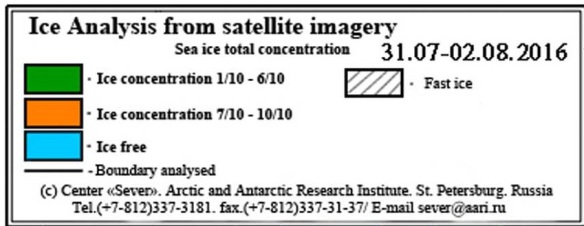
If you hope to see an ice-free arctic, you likely favor the Bremen maps, for they tend to be MIM. (Much Ice Missing.) However if you are a sailor you don’t want to miss ice that is actually there, and are prone to look at the Russian maps, which are prepared for actual seafaring people.  This shows the ice around Wrangle Island looks more formidable than the Bremin map shows. (Wrangle Island to right).


Northabout 20c Screen-Shot-2016-08-20-at-17.26.08-1024x751

Rather than able to turn northeast and pass north of Wrangle Island, it looks like Northabout will have to turn southeast and hug the coast. This makes their route considerably longer. Then, once they pass under Wrangle Island, their problems are not over, as the larger Russian map still shows a second barrier of ice extending from Wrangle Island to the southeast, right to the coast.

Northabout 20d Screen-Shot-2016-08-10-at-09.35.55

The green color on the Russian map indicates the ice could vary between 60% and 10%, and you can bet the crew of the Northabout is hoping for 10%. They will likely be scanning the satellite maps for a more northern gap in the ice, for hugging the coast takes them even further south, likely adding an extra day to their sail, and they are running out of time.

(There is no turning back, as it looks like the ice has been blown south in the West Laptev Sea right to the shore. Not that they’d even consider it. Pilots crossing the Atlantic in the early days of flight used to speak of a “point-of-no-return”, (where it took more gas to reach land going back than continuing forward), and the Northabout has passed that point.)

The Bering Strait should be wide open, but towards Barrow yet another protrusion of ice juts down from the north, and the Barrow webcam shows that even the water that is blue on the Russian maps holds scattered bergs.

Barrow 20160821 05_47_24_126_ABCam_20160821_134400

They are planning on spending a couple days in Barrow to re-provision, and exchange crew members. I am wondering if they might reconsider the wisdom of battling on. The Russian map shows ice touching the coast, where the Canadian Ice Service shows open water at the southwest opening to the Northwest Passage. (I would tend to trust the Canadians in their own waters.)

Northabout 20e CMMBCTCA

The satellite has very clear skies over the southern part of the Northwest passage, showing ice-free waters, but blasted clouds hide the areas of interest to the east and west. The satellite view does give us a dim view of where the Canadian Map shows some ice threatening to close the passage where it jogs north.

Northabout 20f 18

For selfish reasons I hope they continue on, so I can get first-hand reporting. However I think the good crew of the Northabout may be getting tired of discovering ice where maps, especially the Bremen map, says it isn’t.

(I’ll try to include some temperature maps in an update, later.)

 USING MY LYING EYES

O-buoy 14 has drifted slowly against the normal flow of the Beaufort Gyre, southeast to 75.9°N, 136°W. Its camera gives us an opportunity to use our eyes, rather than trusting in maps. What does it show us?

Obuoy 14 0821B webcam

As we have been seeing for several days, O-buoy 14, after a brief stint in open water, is midst a mass of pulverized ice, currently with some open water in the upper right distance, and a small patch of open water ruffled by the breeze in the mid-foreground. But what leaps out, to me at least, is the slushy water in the foreground. It is refreezing, and even rounding the sharp edges of some bergs into a formation called “pancake ice.”

This is what I love about these arctic cameras. You can’t get this information from graphs. What do graphs show us?

The temperatures have been below freezing.

Obuoy 14 0821B temperature-1week

It is still breezy, though winds have slacked off some.

Obuoy 14 0821B windspeed-1week

One thing I have witnessed too often is how Alarmists and Skeptics can look at the exact same graphs and come to very different conclusions, and paint very different pictures. The camera frees us from that. The picture is painted by an Artist far greater than any of us. The Truth is there, for eyes that see.

With my weak vision I see the yearly battle between basal melting and surface freezing underway. The surface freezing always wins in the end, but right now we exist in a marvelous equipoise, even as the daylight dwindles and the big chill gains strength. For a time the refreeze makes inroads, and then a thaw fights back and basal melting can eat surprising holes.

If you are the captain of a ship your eyes must be constant assessing the situation. In the old days the whaling ships dared sail far north, seeking the un-hunted whaling grounds, but they had to time their escape south right, or their ship would be trapped. Now the captain of the Northabout sails the same seas, scans the same situation, and wears the same shoes. The responsibility is not small, when you are not sitting in an armchair far away, making excuses for the fact the Pole isn’t as ice-free as you thought it would be. You face a sea that doesn’t care about excuses.

*******

I promiced I’d look at the temperatures the Northabout may face, so I’ve gone to the Weatherbell Site and poured through some of the thousands of maps Ryan Maue makes available. I prefer the Canadian maps in the short term, for they know their business up north, [but I have to shake my head at the “JEM” model’s habit of foreseeing fabulous storms in the long term. I have learned not to panic, for the major hurricanes roaring up the east coast of the USA haven’t happened (so far.)]

The days are still longer than the nights, and one thing the midday maps show in any arctic area is how toasty warm the Tundra gets. Look how nice and warm it is in inland Alaska today.

Northabout 20g cmc_t2m_arctic_3

However look at inland Alaska only 12 hours later. Much colder. This doesn’t happen in high summer, and what it shows is that the nights are swiftly growing longer, and starting to have a definite chilling effect.

Northabout 20h cmc_t2m_arctic_5

The above maps also show that the storm I dubbed “Ralph” is sitting north of Greenland, keeping a lot of cold air wrapped up and trapped in its circulation. It also shows a sort of “feeder band” of juicy air poking north through westernmost Siberia, to fuel further mischief and perhaps keep “Ralph” going. Likely a secondary storm will brew in the Laptev, and the Northabout, being well to the east, will be blessed by southerly winds that push the ice away from shore.

However when I glace at the winds shown by the JEM modle for Tuesday, the south winds look fairly strong at Wrangle Island. Once winds get above 20 mph they can actually slow you down, because you have to reef your sails.

Northabout 20j cmc_mslp_uv10m_arctic_13

Also I should say the map looks messy. Chaos is rearing its head, and computer models like things nice and neat. So I’m not sure I trust the forecast.

Check out the temperature map for five days from now. Remember, days are still longer than nights, and at noon in Siberia it should be nice and toasty over the Tundra.

Northabout 20l cmc_t2m_arctic_21 (1)

For goodness sake! That ridiculous model is showing an arctic outbreak of freezing temperatures blasting south nearly to China! And it is only August!

This could get me off into a  long digression about a loopy ( or “meridional”) jet stream, but I am fairly certain the good ship Northabout is not overly concerned about the weather in China. They only look ahead to Barrow. And things do look a bit warmer there.

One fun thing to do with these maps is to open them on new tabs, and click between them. When I do this, and compare the 24-hour temperature map with the 120-hour temperature map,  the warming at Barrow is plain, but when you head further east to the Northwest Passage, you see the big chill sneaking south. The outbreak may be far smaller than the one blasting towards China, but it is there.

“Polar Challenge” indeed.  The Northabout has quite the battle ahead.

The thing of it is: Even to complete the Northeast passage is quite an achievement, in a small boat. I won’t mock or shame the Northabout if they haul out at Barrow, and say, “Wait until next year!”

After all, that is what certain “Climate Scientists” do. Year after year they say “this summer the Pole will be ice-free.” Year after year they are dead wrong, yet the government showers them with money. Surely the Northabout deserves the same, if they too say “wait until next year.”

But…..(and forgive me for pouting just a little here)….what about me? Year after year I am dead right. What do I get?

(Sigh)…….nothing but abuse.

MONDAY UPDATE

They continue to slog east-southeast. Making decent time, but the winds are starting to turn against them, and the going may be a bit rough tomorrow, I fear.

Northabout 21 Screen-Shot-2016-08-22-at-23.45.06-1024x824.png

From their blog:

“N71 13 E161 12 Pressure 1007, Water 6, air 0, UTC 20:30, 22 Aug, East Siberian Sea

Wind against us, so choppy seas. We also got the latest sat photo this morning and having to go further south even more to avoid the ice.

BUT slowly going East. Ice tomorrow I think.  The Irish in 2004 had a torrid time around here with the ice, so hoping we get better luck…”

Strong southeast breezes start blowing south of Wrangle Island tomorrow night and persist several days.

Northabout 21b gfs_mslp_uv10m_arctic_6

TUESDAY MORNING UPDATE

Yesterday the good ship had to assume a heading of due south and even southwest to avoid the southern edge of a tongue of ice. They got all the way down to latitude 70° north before turning east, and successfully negotiating the southern edge. Now they are plugging east at 9-10 kmh.

Finding ice so far south doesn’t further the assertion we are close to having an ice-free Pole this summer, but it does further my statement last spring that the ice had been pushed over to the Russian side. They hope to find smoother sailing on the North American side.

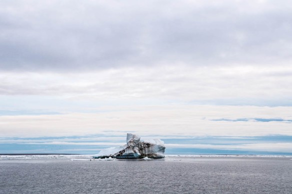
Coming so far south puts them further away from the tail end of the six months of “midnight sun” at the Pole, and they experienced actual night and saw their first stars in months. They also shared a truly marvelous photograph, with northern lights:

Northabout 23 сияние-1024x682

This picture, besides being beautiful, demonstrates how all the arguements about how the low “albedo” of September’s open waters means the water absorbs sunlight are hollow. The waters in the picture are losing heat, and warming the moonlight.

It looks to me as if south winds should push the ice ahead of them north, and clear their path to Barrow, though I’m sure they’ll take extra care at night to be on watch for stray bergs.

“Yesterday was very interesting, we plodded south to avoid the ice. I came up early to get ice on my watch. Oddly, with the sun in the right direction you get a thing called ‘Fata Morgana’ and the ice looks like towering ice cliffs. You can understand why the early explorers saw these cliffs and thought the route barred.

Then Sunset. Poor Constance had a full watch of dodging ice in the dark, thank goodness eating that bird seed has helped her night vision. Then our first star and a dazzling first display of the Aurora Borealis. What a day.

The new ice charts showed we were right to come south, and now just skirting the southern edge. Now hopefully a straight line to Point Barrow. Get those eastings up. Amazingly, the ice charts show how lucky we are, the Laptev sea is now closed behind us.”

ARCTIC SEA ICE –Volga, I mean, Lena Boat Men–(updated)

The Northabout has been making better time, as it passes the delta of one of the most fantastic rivers on earth.

The Lena River is one of the ten largest in the world. It goes from nearly being frozen solid in winter to amazing floods in the summer. As I recall off the top of my head, 3% of its flow occurs in January, and 40% in August. In places the water level in the Lena River rises 60 feet during the August Floods. During the floods the salinity of the Laptev Sea decreases, so much fresh water pours into it. Along with all the water comes all sorts of Siberian trees and branches, so that is something besides bergs the crew of the Northabout have to be wary about.

My preconception was that the surge of fresh water brought north by the Lena floods created a slightly milder lens of fresh water near the delta. Maps show the area as ice-free. Therefore I was surprised when on the 17th they mentioned having to take care about bergs in fog. This shows the importance of on-the-scene reporters.

Northabout 19a DSC_1142-600x400

FRIDAY UPDATE

They have made decent time east across the Laptev Sea, but complain a bit about meeting areas of ice in waters the maps show as “ice-free”. This occurs because, once the amount of ice dips below a certain percentage of a “grid-cell”, it stops being counted. I’ve seen maps where ice is not counted as “existing” when it is high as 30%, but the saner maps tend to use 10% as the cut-off point. But, when you are in a small boat, 1% can damage your craft if you pull off a Titanic. Also, the ice does not arrange itself in a dispersed manner in the “grid-cell”, but can be a sort of swirl, and form a line of bergs like a ice-bar or ice-reef, which must be navigated.

These sailors want to haul ass and don’t appreciate anything slowing them down, but the above picture shows something else they may have forgotten about:  “Twilight”.

Until you have experienced a winter up at high latitudes, you cannot imagine how depressing the winter darkness is. Conversely, until you have experienced a summer at high latitudes, you can have no idea how intoxicating the endless sunlight is. Dark ceases to enter your calculations, and you enter a sort of state of delusion, until the dark comes creeping back and twilight returns.

As these sailors hurry east they are going to increasingly be confronted by darkness limiting their visibility. Their solar panels on the deck will be less and less effective, and as each twilight grows more dusky they will be less and less able to see the stray bergs they come across in “ice free” waters. Do they have searchlights, and the generators to power such lights? (Also the stray bergs can create mini-fog-banks in calmer weather, which is yet another thing to slow them down, as such fog renders searchlights useless.)

The Northabout is facing increasing challenges, even as they thought they had left sea-ice in their past, and sailing would be clear and easy.  Best wishes to them, as they approach the entrance to the East Siberian Sea.

(EXAMPLE OF HOW QUICKLY ARCTIC SEA CONDITIONS CAN CHANGE, FROM DRIFTING O-BUOY 14 IN THE BEAUFORT SEA.)

YESTERDAY AFTERNOON:

Obuoy 14 0818 webcam

THIS AFTERNOON:

Obuoy 14 0819B webcam


ARCTIC SEA ICE –Northabout Battles Sea-Ice Through Vilkitsky Strait and Laptev Sea (Updated 5 Times)

When temperatures are over ninety (32.22° C) there is nothing like pictures of sea-ice to cool my crazed brain. Cooling is especially nice if one is politically inclined to scoff at Global Warming as a serious threat, and the sea-ice is proof that Global Warming isn’t happening in the manner proscribed by believers in the “Arctic Death Spiral.” But when sailors are taking the pictures, of the sea-ice I enjoy, there comes a point when the importance of politics fades away, because the photographers are facing death.

Not that one cannot die for political things, and die for their country, or their platoon, or their gang, or their wife, but such sacrifice is beyond the scope of ordinary politics. Ordinary politics, especially in recent times, is far more sleazy and selfish, and, rather than sacrifice, tends to focus on “what is in it for me.” People get busy keeping petty accounts that note how many times they scratched another’s back, and how many back-scratchings they have received and are owed, and if accounts do not seem right, they resort to back-stabbing.

To be honest, it disgusts me. Modern politics has all the spirituality of a leech, and all the love and romance of a cheap business transaction involving the purchase of the daily paper. I increasingly feel that it isn’t only me, and that the public is also disgusted, and cynicism is rife. Cynicism rises up as a king,  belittling hope and optimism, until an unlikely redeemer appears,  and our common enemy, Death, rises up and waggles his fingers with a friendly, “Hello”.

The reason people sail the Arctic Ocean or climb Mount Everest, rather than staying in a cozy and safe armchair,  is because risk is a redeemer.

It is amazing how quickly the threat of extermination will cut to the chase, and get people to get over their differences, and work together.  Unfortunately some politicians are adept at misusing this phenomenon, and create false threats to motivate populations to act. For an extreme example, most genocides are based on portraying a minority as a life-threatening threat to a majority, which the majority  must rally together to kill.

I am increasingly certain Global Warming is just such a false threat. It’s creators seemingly aim to exterminate opposition to their political agenda, which is an agenda I find repugnant, as an American, because the agenda loathes the liberty of the individual.  To cut a long discourse short, the agenda loathes private ownership of anything, seeking to enforce brotherhood with a club.

The Agenda dislikes mothers nourishing their babes, because Family Values are charity, which begins at home, because a man’s home is his castle, and even such a little patriotism as that is a threat to internationalism, which loathes patriotism of any sort.  Therefore internationalists twist a mother’s love into being a sort of hate:  If you love the baby God gave you then you are not being equal and fair to some child starving far away, and this makes you a racist.

In like manner internationalists loathe the love a man displays when he goes to the trouble to open a small business. As soon as a man steps from being a person who works for another to being a man hiring workers, he becomes slime. He is a “boss”, as if that is an evil.

In conclusion, internationalists in their ivory towers can become the enemy of love, in any sort of normal and natural form love has, that street-people can relate to.  Rather internationalists profess the love of Stalin, who is said to have subscribed to the idea that, “The death of one is a tragedy; the death of a million is a statistic.”

In other words, “It is the big things that matter; little people can be damned.”

This is fundamentally different from the American idea that, “All men are created equal.”

Americans believe, if they examine themselves, that a mother nursing her babe is equal to a Stalin, with all his might and all his power. Furthermore, she has the same single vote Stalin has, and the same control of our destiny. Stalin can bluster all he wants, muttering, “The ends justify the means” and, “Might makes right” and, (write in here any other justifications for bullying you desire). Still that poor mother has the power of Stalin, if America lives up to Her dream.

Global Warming is an attempt to create a false threat, because its creators know mothers will sacrifice their own well-being for the well-being of their babies. However it is a threat born of the cynical genius of politics, which has outlived its shelf-life.

Where a snake-oil salesman knows when to depart a town in a hurry, and seek a new town where the population is gullible and naive,  the perpetrators of the Global Warming alarm have no place to run; they have sold their snake-oil too widely; it is a case where they have no place to hide and internationalism has become a bad thing even for internationalists, for even remote Eskimos know all about Global Warming. The sheer, grinding nastiness of their cynicism has created a cynical populace, which increasingly doubts everything politicians and the Media claims.

Death is quite another matter. When it waggles its fingers at you, you are not the slightest bit cynical.

This was most especially obvious during the 1800’s in the age of sail. With members of a crew liable to be washed overboard or die of scurvy, captains had to hire new crew-members from alien cultures.  And, within the pages of writings such as “Moby Dick”, it is obvious that crew-members of very different racial, political, cultural and religious backgrounds would drop all their differences, when the alternative, (to working together as a team), was death.

This is something the Sea teaches much better than the Land does.  Stalin tried to teach with bullying death, but his schools always involved barbed wire, gulags and fences. The Sea spits on the very idea of fences. In fact it is the opposite, for it offers freedom.

But freedom isn’t free. It involves risk. It involves going to Sea.

This is what the good ship “Northabout” has done. Gone to Sea. Sure, they left port all puffed with a bloated political agenda about Global Warming, but the Sea slaps your naive preconceptions away with the first storm, when it lays you as low as a dog, with sea-sickness. After that, they could have turned back, but now they are heading into considerable risk, as they attempt to slip through sea-ice.

Northabout 17a DSC_1028

When such ice appears ahead, do you think inanimate ice cares what political party you belong to? If you believe Professor Peter Wadhams, when he makes his yearly headlines stating the Pole will be ice-free this summer, do you think the sea-ice will part like the Red Sea, to let you through?

Northabout 17b DSC_1026

Apparently not. The sea-ice does not read the New York Times or attend Professor Peter’s lectures. Therefore, because the sea does not agree, you are in a pickle, with your way blocked. You must trust the courage of your captain, and your own ability to be a good crew. And perhaps you do find a weakness in the wall of ice:

Northabout 17c DSC_1030

When your captain finds a gap in the ice, it may be like the gap between the teeth of a shark’s open mouth. After all, each berg only represents the “Tip of an iceberg.” The slightest berg, to the upper right, may only extend six inches above the water, but nearly five feet (56 inches) extend downwards. And that is but the smallest chip. How about that bigger berg off the starboard bow? It sticks up four or five feet, which in theory means it should stick down 36 or 45 feet, but these burgs are not always symmetrical with their mass, and sometimes the below-water part can stick sideways 36 or 45 feet.  It could hole your hull. In other words, this is no Sunday sail the crew of the Northabout  are on, over velvet waters, after church. This is for real. What if the shark’s teeth close?

Northabout 17d DSC_0964-600x400

Oh shit. This is no joke, anymore.

Now I am sure some are tempted to sneer, “Where’s your ice-free Pole now, suckers?” However this is no Professor Peter we are dealing with, getting rich by being politically correct in a fat-cat armchair,  and pretending to be a prophet, and announcing the Pole will be ice-free in 2012 2013 2014 2015 2016.

Instead these are very real people. They are not sitting on obese posteriors in some plush. leather Lazyboy, pontificating upon polar conditions from far away places. They are actually in those far away places. They are actually battling the ice that isn’t suppose to be there. They are actually gathering the actual data. In fact, in a worse case scenario, they could be killed by the actual data.

Therefore, rather than sneering, I suggest we do a bit of praying. Let us drop the stupid politics until they cross the Laptev Sea. Once they are safe, then, if they insist upon resuming their political nonsense, we will meet their nonsense blow for blow.

Were it not for individuals who dare test the waters, we’d be all sitting in our armchairs believing the media’s claptrap about how ice-free the arctic is.

Rather than sneering at “Northabout” and calling them a “Ship of Fools”, we should be thanking the crew for facing waters we don ‘t dare face. At the very least, they are showing the “ice-free” waters have icebergs, and they themselves have guts.

Northabout 17e 16693-1

That fellow in red is a “man overboard”, in water that is salty and at, or below. freezing, and can kill a person in five minutes if they fall in. Just who does he think he is, standing on the water? Jesus? No. He is just a working man trying to get to that open water barely visible in the upper right of the picture.

They made it, and crept along the shores, which were ice-free because the southwest winds blew the ice away from shore. This is called a  “Polynya”, and does not mean the ice by the shore is melted, but rather it is moved away. (Northabout located where the white arrow is:)

Northabout 17g 16729-1

However in these “ice free” waters you can come across not only sea-ice, but bergs taller than your highest mast.Northabout 17f DSC_1049.

I find this berg fascinating. It isn’t sea-ice and it isn’t locally grown. I want to take dirt samples. Is it from Greenland’s glaciers? And how did it wind up across the Arctic Sea in the Laptev Sea, when official maps of currents state “you can’t get there from here”? Also why is the geology of the berg’s ice so odd, with horizontal strata and slanting strata?

But the captain doesn’t care a hoot about that. He just sees that open water to the upper left, and also knows big bergs are dangerous. In theory, if they are 40 feet tall, they stick down 360 feet, but as I said earlier they can stick sideways rather than down. Also, because “bottom melt” can exceed “top melt” in August, such bergs can become top-heavy, with their bottoms melted, and can suddenly capsize and what was the bottom can come surging up as the top plunges down. This can be dangerous to a small boat squeezing by.

The good ship Northabout has faced days of dangers, but now a new danger appears. Winds may shift to the north for a brief time. It may be only twelve hours. But all the ice will come grinding south and threaten to crunch a small boat against the shore. So perhaps the captain dodges backwards, to seek a safe place for twelve hours, after which,  perhaps, the south winds will resume and allow sailing east again.

Northabout 17h 16774-1

I will not criticize these gutsy sailors, and instead I will find a private place to whisper a few politically incorrect prayers that they experience safety.

Professor Peter Wadham is another matter. He stated the arctic would be ice free this summer. I will privately pray he meets an iceberg inland, in England.

SATURDAY MORNING UPDATE

They made three attempts to get through the ice yesterday, all in vain. Likely they wanted to get east before a storm hit with north winds. The last thing they want is to be stuck in the ice with the ice moving in gale force winds. It is quite hard enough in a calm.

Northabout 18b 16357-1

All their attempts brought them back to where they started.

Northabout 18a 2

The closest thing they could find to a safe anchorage was a so-called “stamukha”, which is a berg that has been pushed onto shallow water by a storm and is grounded. This particular chunk of ice appears to be genuine sea-ice, and not a large chunk calved from a glacier. It looks like multi-year-ice, either piled up to a pressure ridge where it now remains, or piled up to a pressure ridge somewhere else and driven ashore.

Northabout 18c DSC_1087

From  the safety of my armchair I want to take samples of the dirt on the berg. It might be from a mountain, which would prove the ice was from a glacier. It might be soot from China’s coa;-fired power plants, or from a volcano, concentrated at the bottom of a melt-water pool and then refrozen into the ice. Or it might be alge that grows on the bottom of the ice, and then is frozen into the ice when the ice gets thicker in the winter, or put at the tip of the ice when the ice is flipped like a pancake.

The captain has other concerns, with winds picking up. Will this berg stay grounded in a storm? Will it shelter them from other bergs moving in the storm?

They likely have endured a long, sleepless night, and I’m awaiting this morning report with a degree of anxiety. All I can say is that there is no  sign of movement yet.

*******

ON THE MOVE AGAIN.  They got started at around 7:00 AM EST, which I guess is early afternoon for them, and so far they have made it east about half the distance they probed three times yesterday.

*******

BREAKTHROUGH!  Yesterday they commented that if only could get through the three miles of ice there would be clear sailing all the way to Bristol. I think that may be a bit overly optimistic. But they may find things easier at least to the far side of the Lena River Delta. (The Lena is at peak flood in August, pouring massive amounts of summer-warmed waters into the Laptev Sea.)

Northabout 19 17017-1

*******

DUCK AND COVER

All day I have found myself sneaking to peek at the “Tracking Map” to see how the Northabout is doing. The skipper is amazing. I can’t see how he hasn’t gone aground, he has sailed so close to shore. I figured they had penetrated the blocking ice, and therefore was surprised to see them abruptly turn back.

Seeking a reason, I checked the forecast. Hmm. Looks like they are in for a bit of a blow. The skipper is wise to seek a safe anchorage.

Northabout 20 Screen-Shot-2016-08-13-at-23.47.13-1024x909

ARCTIC SEA ICE –Northabout Awaits Thaw–(With Monday Update)

We have been watching the travels of the Northabout, which is attempting to circumnavigate the Pole this summer, with interest because it will act as our on-the-scene reporter of ice-conditions on the Siberian side of the Pole.

The Northabout is tucked into a cove to the west of Vilkitskogo Strait, which is the western entrance of the Laptev Sea. They are waiting for the sea-ice conditions to improve, and south winds may be helping them out. Skies have cleared, and you  can peer down from outer space by using:  http://www.arctic.io/explorer/4Xa5A//4-N90-E0

I’m going to try to zoom in, copy, and paste the image here.

Drat. For some reason it clipped off the edges. Anyway, the Northabout is off the picture to the right. South winds have cleared a tentative channel right along the coast to thicker sea-ice on the right side of the picture. That thicker ice is broken up, and a gutsy captain might try to pole and poke his way through, with a steel hulled boat made for such conditions. On the other hand, one can sip vodka and wait.

During August the Siberian rivers reach their peak levels of flood, as all last winter’s snow is melted by the long days and is rushing downstream. The floods are unreal. The Lena River (world’s tenth largest) can rise sixty feet from its January levels. All that water pours into the Arctic Sea and creates a “freshwater lens” along the coast, especially in the Laptev Sea. Though the river water is very cold it can melt Sea Ice, and create a brief channel. Interestingly, because it is fresher, it freezes at a higher temperature, and the “freshwater lens” in the Laptev Sea doesn’t need much of an excuse to re-freeze. (Watch how quickly the Laptev Sea freezes in the fall.)

My guess is that they will bide their time and wait for melting. The problem is that they’ll be falling behind schedule.

They are tucked into a bay in an island that is near the center of the satellite shot below. (South to the top.)You can see that the north winds behind the last storm pushed a lot of ice south to the east of their refuge.

Below is a picture posted by “Colorado Wellington” over at  http://realclimatescience.com/2016/08/vodka-and-wine-and-vodka/

(South to the bottom. Location of Northabout marked by the red dot.)

Northabout 9 15139-1

It does look like the last low pressure system pushed the ice southeast, but I’m not concerned about them being blocked in at this point, as winds are shifting to the south as a ridge of high pressure slides over. Then the next low will give them some south winds ahead of it, and may be helpful because it may pull a loop-de-loop in the Kara Sea, keeping them in the south winds and pushing the ice away from shore.  The lows center broadens in the Canadian JEM model, giving them a period of calm if they want to attempt to motor through Vilkitskogo Strait,  72 hours from now.

Hopefully this post will include updates. They are well worth watching.

Tuesday Update

They are still waiting. Some ice blew into their anchorage. “At 4am Constance woke me, bits of floating ice all around.  I thought she was pissed, so got up in my boxers. She was right, with the change of direction of wind, we had lots of bits of loose ice all around the boat, and worryingly, congregating around the anchor chain.”

I wish they’d post some pictures. Also describe how the water temperatures changed as the ice moved in. Maybe they will, later. I sent an inquiry to their blog site.

The blogger “AndyG55” produced this good picture of how the ice blew south, and where they anchored. (South is to the top.) He marked a potential escape route with the yellow arrow, though I think the ice will stay scattered. Winds have since shifted to the west, and it looks like our good satellite view will be obscured by clouds.

Northabout 10 15248-1

Now AndyG55 has posted a picture of the clouds moving in today.

Northabout 11 15259-1

I would not blame the captain for being cautious. One thing the satellites do not show very well is the smaller bergs, and last summer I could watch O-buoy 9 go from being in water that seemed utterly ice-free to a scene of jammed ice in a matter of mere hours.

I’ll continue to update, as this is interesting to me.

*******

Below is a picture of the ice that blew down the harbor and gave them a rude awakening.

Northabout 12 Screen-Shot-2016-08-04-at-12.11.50-1024x571

Thursday Update

Looks like they have to hunker down and wait out a bit of a blow that blew up right on top them. The winds may be clearing the coast of the Laptev Sea but it looks like Vilkitskogo Strait could be jammed up. The storm will fade by Sunday, and then they’ll have to appraise the situation.

Northabout 13 gfs_mslp_uv10m_arctic_2

Saturday Morning

It was a good thing they were in a safe anchorage, as the storm gave them gale force winds gusting up to 38 knits, and near white-out conditions of fog, rain, and some wet snow. Air temperatures were around +2°.

The storm is now filling and fading to the west.PS1 cmc_mslp_uv10m_arctic_1

By Sunday morning their north winds should have slackened, and they will be able to appraise how much ice blew south to block their route.

PS3 cmc_mslp_uv10m_arctic_5

By Monday morning a very small low will develop in the wake of the departing storm, and they may see winds shift to the south as it approaches.

PS5 cmc_mslp_uv10m_arctic_9

It is more of a test than you would imagine to be trapped in a boat with the same people day after day, especially when you can’t even go out onto the deck to see the sky. Until the strait clears there is nothing they can do but be patient and wait.

Here was the ice-situation before the storm (from Ron Clutz’s site). I’ll have to figure out how he gets these maps.

https://rclutz.wordpress.com/2016/08/04/polar-challenge-meets-laptev-wall/

Northabout 14 laptev-gateway

Northabout 15 ru-legend

SUNDAY UPDATE  –STILL WAITING–

We are getting our first glimpses through the clouds as the storm fades, and it looks like their is still ice in the strait, though it may be less concentrated in places. There is a sort of geology to sea-ice, and I can see what I call “ice bars”, for they remind me of the sand bars that form along the sandier parts of the east coast. They shift fairly swiftly, and I doubt one would seek to plow through them in a sailboat the way one can do with an icebreaker.

If they do attempt a run along the coast they will be keeping an anxious eye to the north, for the ice can return. A very good example was seen up in Barrow Alaska last week. The ice was gone, and none could be seen on the horizon, for over two weeks, and then it returned abruptly, and crunched up against the shore. At low tide it could be seen that the bergs were fairly thick; definitely not slush. Briefly there was a second mass of ice visible on the horizon. Hopefully a link to the webcam (atop a bank building) can be seen here:

(I’d hoped to preserve the above video for posterity, but unfortunately it stopped working when it was replaced by a updated 10-day video. You can still see the sea-ice (for a few more days) by going to the website and hitting the ten-day-animation, but when the event recedes more than ten days into the past it will be harder to find a record of it.  The website is here:

http://seaice.alaska.edu/gi/observatories/barrow_webcam

Once the visual record is unavailable you’ll just have to take my word for it that what happened happened.)

If a sailboat was coasting along the shore and a mass of ice like that came south the captain would be in for some difficult maneuvering, and the crew busy pushing the bergs from the boat with poles. In a worst case scenario they might be driven ashore with the ice. So I can see why a captain would wait in a safe anchorage, even if the vodka ran out.

I should note that the satellite didn’t show the ice at Barrow as anything worse than milky-looking water. The ice is more impressive when you meet it face-to-face. (Also note that, although Barrow is well north of the Arctic Circle, the sun dips so low to the north at midnight that it briefly sets. The time of 24-hour sunlight has past, and the chill will start building.)

MONDAY UPDATE

High clouds continue to make it difficult to get a clear picture of the ice conditions in the strait.

They now have been biding their time for a solid week, and are likely suffering a small-craft equivalent of cabin fever. Fortunately conditions grew calm enough to test out the dingy, and they got to walk a bit on solid ground, before a mother polar bear with two cubs gave them an adrenaline rush, and caused a hasty retreat.

Northabout 16 IMG_3454

The bears look rather healthy, and seem to cast doubt on Al Gore’s suggestion that polar bears starve without sea-ice. A good reference, if you want to learn more about this subject, is Susan J. Crockford’s site:

https://polarbearscience.com/

Apparently polar bears do most of their eating in the spring, when new-born seal pups spend their first week helpless, by air-holes in the ice. By the time the ice melts the bears are obese, and quite able to get through the summer only nibbling a bit, subsisting on body fat. Susan points out that what really reduces the bear population is too much ice, for thick ice means there are no air-holes for seals, and the seal population takes a dive, which means the bears go hungry, and few cubs survive. (Al Gore’s weepy movie was wrong, in this respect, among its other errors.)

In any case, our sailors got some excitement, which is just the tonic needed to alleviate boredom, as they wait. They also received a another real-life lesson. Misconceptions, whether they be about sea-ice or about polar bears, tend to be self-correcting, provided you keep your eyes open and seek the Truth.

ANCHORS AWEIGH. Monday afternoon.

They’ve finally headed east toward the strait. Best wishes.