ARCTIC SEA ICE RECOVERY —THE VIEWLESS VIEWER’S VIEWS—

This is a continuation of a series of posts, the last of which was, https://sunriseswansong.wordpress.com/2014/01/07/arctic-sea-ice-recovery-days-lengthen-cold-strengthens/

If you are a first-time visitor I will simply say this post will get longer and longer, as I add updates to the bottom several times a day. If you revisit the site to check up on the latest update you can enter on my home page, and click the little “comments” balloon to the right of the title, and that will take you to the bottom of the post, where you can scroll up a short ways to see the latest. This avoids the bother of sometimes needing to scroll down a long, long ways to see the latest.

Secondly, I should say this series of posts began discussing the views from the North Pole Cameras.  Camera 1 has been retrieved by an ice-breaker, while Camera 2 was flattened by a polar bear and then covered with snow, and the fellows from the icebreaker couldn’t locate it. Furthermore all the O-Bouys have been shut down for the winter, (likely because they are solar powered and there is no sunshine up there, these days.) In conclusion, you are reading a post about views when no views exist.

I have considered shutting down this series of posts until spring, but I have a stubborn streak.  Also there are still views, though they are very, very long-range views, from a satellite.  Nothing can be seen with visible light, until the 24-hour-darkness ends, however they are able to gather some data via radar. (There is debate about how valid such data is, but let’s skip that for now.)

I try to make the meager information we receive interesting, and also to talk a little about how the arctic is effecting where I live, in southern New Hampshire in the USA. However for the most part this post is more like a notebook filled with my sketches and scrawling.  If I happen to come up with something worth more than mere wondering, I will usually write a separate post.

I’m prone to purple prose, and from time to time hide a sonnet in my prose just for the fun of it. At the end of my last post the hidden-sonnet had the rhyme-scheme words: “Gray, blues, play, brews, chimneys, rack, trees, back, lay, its, gray, wits, drawing,  and thawing.”

(And yes, I know it is sort of illegal to end a line with “its”, but I’m the boss of this blog, and if I want to cheat it is allowed.  But only for me.)

I tend to look at polar weather maps twice a day, and look at my own neighborhood (and life) at the end of each day, and occasionally look at other parts of the world, (including, one time, the Sahara Desert, which must be a sea-ice first.)  However I attempt to tie everything back to sea-ice, which is the “sun” all else orbits (supposedly) in this post.

Each news item will have a headline, and appear as follows:

JAMMIN’ IN THE BEAUFORT GYRE  —(Keep your eyes on this)—

The ice was flushing nicely down through Fram Strait nicely at the start of the winter, but more recently wrong-way-winds have created a new clot up in Fram Strait, keeping sea-ice from exiting the Pole.  This is a bit like the situation we had last summer, which seemed to keep the sea-ice from melting by keeping it condensed, and also by keeping it up in the arctic, and lastly to even increase the multi-year-ice north of Canada, by cramming ice that way rather than flushing it down through Fram Strait.  We now seem in a mid-winter version of the same situation.  The current drift of the ice towards the Beaufort Gyre, rather than towards Fram Strait, is seen in this drift map: (Click twice to fully enlarge.)

Speed and drift Jan 29 arcticicespddrfnowcast

The thick multi-year-ice appears as reds, yellows, and greens in the map below.

Thickness January 29 arcticictnowcast

You can seen a little red leaking away down the east side of Greenland.  You’ll have to take my word for it, (or visit other sites to reaffirm,) that this is less ice escaping than occurred during other winters. You’ll also have to take my word for it, when I say much more of the thicker ice is remaining behind north of Canada, and now even north of  Alaska, than was there at this time, only two years ago.

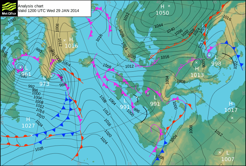
JANUARY 29  —AFTERNOON DMI MAPS—

DMI Jan 29B pressure mslp_latest.bigDMI Jan 29B temp_latest.big (1)

The two-lane-highway of cross-polar-flow seems to be reforming, after being split by the intrusions of milder air from both the Atlantic and Pacific sides.  The center of the Pole remains much warmer than normal. The cold on the Canadian side is being sucked south over the Canadian Archipelago by the strong gradient between the 950 mb Labrador Low southwest of Greenland and the 1030 mb high over the Canadian arctic coast. The cold on the Siberian side is extending towards the Pole as the “Snout of Igor” reappears. (For first time readers, “Igor” is the persistent extreme cold and high pressure over Siberia, and his “snouts” are the bulges of cold moving out from that center. “Igor,” (or Siberia,) is colder than the North Pole and even the Icecap of Greenland, this time of year. We have been watching one bulge that intermittently sends shots of cold across the Pole into Canada, and a second bulge that has recently extended east towards Europe.)

QUICK GLANCE AT UK MET MAP —Battle of the Bulge—

UK Met Jan 29B 11891746(click map to enlarge)

The western “Snout of Igor” continues stand as a strong bulge into Scandinavia.  It has shunted the Icelandic low south, and the last attempt of the North Atlantic to restablish the Icelandic Low is now being discarded south over France towards a more southerly storm track through the Mediterranean. This map is the closest we have seen to the map we’ve been on guard for, indicative of the negative AO and NAO.

A A Screen shot 2013_05_19 at 10_33_10 PM(1)

The truly cold pattern hasn’t fully developed, and at this point the patterning seems more like a hybrid pattern, wavering back and forth between having an Icelandic low and suppressing it.  One sign the Icelandic low may try to reassert itself is that the Labrador low is weaker, (up from a 950 mb low to 961 mb low, and seems to attempting the morphistication of the towering Greenland icecap. (To newcomers, “morphistication” is my word for “transit” or “cross-over,”) This is shown by the 973 mb forming on the east coast of Greenland, complete with a web of fronts hanging south.  Earlier in the winter we saw such morhpisticated lows become strong as they moved towards Iceland, but computer models suggest this one will weaken.

A second attempt to reestablish the Icelandic low will occur as the low I dubbed “Whiff” (as it passed out to sea and missed my locale,)  appears in the lower left of the above map and heads out into the Atlantic, turning into a gale center. We need to watch it, to see if it heads towards Spain or up to Iceland. (The last one split the difference, and headed straight to England.)

It is interesting to note that the high over Iceland often creates a calm, or even a slight south wind, way east in Fram Strait, keeping the sea ice from flushing out of the Arctic Ocean.

A QUICK LOOK AT ASIA

In order to truly comprehend the enormity of cold in Igor’s gut in eastern Siberia, it pays to look at a temperature map of that region. (Click map twice to fully enlarge)

Igor Jan 29 cmc_t2m_asia_1

All the pink area on the above map is colder than the magic minus forty, where Celsius and Fahrenheit are the same, and the pinkest pink indicates a temperature of minus 73.3 (58.5 Celsius).  In other words, the center of cold in the north is not the North Pole. Canada is a second center, but rarely can match such cold, and when it does it is usually because Siberian air has crossed the Pole and then lingered to chill further over Canadian snows.

When Siberia speaks, northern lands tremble.  The best-case-scenarios for most people are when the cold drains east into the Pacific, for when it drains south China suffers, and when it drains east Europe freezes, and when it drains north the Americas can expect their coldest arctic outbreaks.

In the above map you can see one snout bulging west towards Europe, fighting the Atlantic’s desire to push warmer air east. A second plume of cold pours out into the Arctic Ocean like a curving feather to the northeast, and towards Alaska, Canada, and the USA.

(If you are a European fearful of fuel-poverty, you hope that northern plume sucks all the cold out of Siberia, leaving little behind to move west towards Europe, (and perhaps thinking it is the turn of the Americas to taste how fuel-poverty is bitter, and what dunderheads politicians who intentionally raise fuel prices are.)

In order to get a feeling for the flow of winds at the surface it is helpful to look at a map of Asia with winds and isobars shown. Then you get an idea where the cold is headed.

Igor Jan 29 cmc_mslp_uv10m_asia_1 Double click to fully enlarge

This map shows a strong high pressure over eastern Russia delivering murderously cold east winds westward on its underside, and giving Scandinavia a sort of uppercut of cold from the southeast.  Meanwhile the north side of this high is drawing slightly milder air east along the arctic coast of Eurasia, which may weaken the high, as warm air weakens highs because it rises and rising air lowers pressures at the surface.

A second high to the east is delivering the coldest south winds on earth up into the Arctic Sea. Even down on the coast of Antarctica, the south winds off the coldest continent are not this cold, in January. (In July they are worse.) However this high also has its warm side, sucking slightly milder Pacific air in from the Bearing Strait.

I haven’t a clue what these high pressure systems will do. I’m just an observer.

GIVING CREDIT WHERE CREDIT IS DUE

The above two Asian maps are the work of Dr. Ryan Maue, who creates them from the data spewed out by various forecast models.  I get them from the WeatherBELL site, and they cost me the price of a cup of coffee each day. When you consider how many models there are, and how many maps can be produced by the model’s data extending ahead, three-hours-at-time, to 360 hours, and how many different types of maps can be produced including various levels of the atmosphere, and various elements of those atmosphere such as humidity, wind speed, pressure, temperature, and stuff I haven’t learned about, there are over a thousand maps to look at, and they update between two and four times a day. I think it is a gold mine, if you are interested in weather, and my understanding is you can get a free trial for a week, if you are even cheaper than I am. (Also you get the opinions of two fine old-school forecasters, Joe Bastardi and Joseph D’Aleo.)  This resource can be found at http://www.weatherbell.com/

Another great resource is provided, absolutely free, by Anthony Watts on his “Sea Ice Page.”  This gold mine compiles a whole slew of other free sites without the bother of having to search for them.  It also allows you to access the sites without dealing with the annoying fight going on between Alarmists and Skeptics. You can even avoid my brilliant wit, if you have a headache and my brilliance hurts your eyes.  This site can be found at:  http://wattsupwiththat.com/reference-pages/sea-ice-page/

There are many other excellent sites I hope I never fail to give credit to, as I steal from them, however the above two sites are in a league all their own.

LOCAL VIEW  —Sneaky cold—

A battle 65 satsfc (3)A battle 65 rad_nat_640x480

The maps show that “Whiff” has run harmlessly away past the Maritime Provinces of Canada, and that there is no snow in a thousand miles. However maps don’t always show the full picture. Even as “Whiff” headed away, and maps showed the cold “lifting” away to the north, we got hit by a little bit of nasty cold, swung south by Whiff as he departed.

The maps do not show the typical arctic outbreak pushing a cold front, when a storm is as meek as Whiff was, but Whiff had his little backlash.  It was one of those things that are very real, if you spend time outdoors, that maps utterly miss.

Don’t get me wrong. I adore maps, and greatly enjoy pouring over the results of the efforts of others. I am well aware someone worked late into the night to produce the maps, and therefore I am not blithe about dismissing them. However I also know they are approximations, and miss the little details at times.

Little details can be big, in the microcosm of a Childcare. If a golden day turns windy, and the wind has a sting, I need no maps to fear the children will get cold.  I need no maps to hustle about and build a fire so big you have to step away, to avoid the radiant heat.

Even then, I miss obvious details. When a  kid takes offence over another kid, and slumps by the fire,  I tend to assume they are merely offended. In fact the child may be coming down with the ‘flu.  His rude responses to my care may have nothing to do with rudeness. His shivering may have nothing to do with the weather. The kid is just sick.

Little details can be big things.  Therefore I am noting that rain and snow down in Florida, though no model shows a storm coming up the coast.

The big detail on the map is the broad southwest flow behind the arctic high currently freezing our socks off.  Oh! That sure would be nice!

However I’m keeping my eyes peeled for those sneaky details.

JANUARY 30 —MORNING DMI MAPS—

DMI Jan 30 pressure mslp_latest.bigDMI Jan 30 temp_latest.big (1)

JANUARY 30 —DMI AFTERNOON MAPS—

DMI Jan 30B pressure mslp_latest.bigDMI Jan 30B temp_latest.big (1)

(click images to enlarge)

The high over Russia continues to waft light and mild winds towards the Pole on it’s warm west-side, now bringing a slight thaw to Svalbard., and “balmy” +5 readings to Iceland. The Pole is averaging (north of 80 degrees,) some ten degrees above normal, -15 rather than -25. (Remember it is -50 in Siberia.)

Pacific air is being drawn in through the Bering Strait along the east Siberian arctic coast.

Between the two the Snout of Igor is pouring air from Siberia across to Canada. The isotherms seem to indicate the channel is narrowed slightly in the past 12 hours, but the -20 isotherm now extend nearly across to Canada. Remember that this air is warmed as it crosses the Arctic Sea, despite the ice-cover, but also that this warming tends to be shallow. As soon as the air gets over land again in Canada it chills rapidly.

JANUARY 31 —DMI MORNING MAPS—

DMI Jan 31 mslp_latest.bigDMI Jan 31 temp_latest.big (1)

The most interesting feature is that little, tight low moving the wrong way along the Siberian coast.  It’s east-side winds are drawing cold air from Siberia north. Models suggest it is the first of a series of wrong-way lows. More typically lows enter the Arctic Sea on the Atlantic side and head east along the Siberian coast, getting weaker as they lose their source of Atlantic fuel, but often discernible all the way to Bering Strait. Now it is as if the lows are circling clockwise around Igor in Siberia, rather than circling the Pole itself.  This may have something to do with the warming of the Stratosphere high above, an event which has only been a forecaster’s focus for the past decade or so.  It is new territory and a frontier.

The Icelandic low may be trying to reestablish itself on the Atlantic side.

The Pole itself has little identity, and seems more like a boundary between other forces.

QUICK LOOK AT UK MET

UK Met Jan 31 11929143 (click to enlarge)

“Whiff” has exploded into a powerful North Atlantic gale, and looks like it is splitting-the-difference and heading straight towards Britain.  The Snout of Igor is remaining strong, and the flow between the two will be from the south, however it will have less of an ocean component and more of a continental component than the southerly flow back in December: More of a southeast flow than a southwest flow.

Up in Fram Strait the wrong-way flow continues, though it may return to a more normal north wind if “Whiff” occludes and loop-de-loops back towards Iceland, which is what some models suggest.  If the Icelandic low reestablishes itself things will become more ordinary, but if a lot of Whiff’s energy escapes under the Snout of Igor lodged over Scandinavia, into the Mediterranean, then the pattern is changing.

LOCAL VIEW —Southwest flow—

A battle 66 satsfc (3)A battle 66 rad_nat_640x480

No stars in the sky this morning, as the southwest flow around the back-side of the last arctic high starts to bring moister mildness north.  The radar shows it is snowing down in Dixie, so it is not all that mild.  However, after days when it’s been the single digits at daybreak, you tend to call 19 degrees (-7 Celsius,) in the dark before dawn “mild.”

It’s a relative mildness, and your skin does recognize it as being milder, but down deep I don’t think you are fooling anyone. Yesterday was a gloriously sunny day, but cold. I was trying to enjoy the sun as I lugged firewood to the front porch, and attempting to take delight in the fact the temperature was inching through the teens up past twenty, when suddenly it occurred to me, “I’m sick of this.”

Into my mind crept one of my earliest memories, when I must have been at preschool age, for I was kicking around the house as my mother chain-smoked and payed bills at her desk. I was bored, but couldn’t go outside because it was too cold. Abruptly a thought occurred to me, and I trotted over to my mother and asked her, “Mom? Does January mean it will be spring soon?”

She looked downright startled that I should ask such a question, and replied, “No, dear. Spring won’t be for a long time yet.” I must have slouched in deep, ridiculous dejection, for a smile flickered on the corners of her lips. As I walked away I was slightly offended. Waiting for spring did not seem like a laughing matter.

Now here it is, well over a half century later, and I am no better at waiting.

Looking ahead there is nothing to see but (as Joe Bastardi puts it) “storms and rumors of storms.” All the month of February; all the month of March; and even April is a long tease around here; spring never really busts out until May.

I suppose this is what separates the men from the boys, but I’m weary of winter already.

FEBRUARY 1 —DMI MORNING MAPS—

DMI Feb 1 pressure mslp_latest.big DMI Feb 1 temp_latest.big (1)

Pushes of milder air continue to invade the Arctic Ocean from both the Atlantic and Pacific side,  with a slender and disjointed flow from central Siberia to Canada between them. Strong high pressure over Russia is squaring off against strong low pressure (“Whiff”) south of Iceland. A weak low has again formed due to the intrusion of Atlantic air lifting north of Greenland, assisting the continued wrong-way-flow northward through Fram Strait. Meanwhile the wrong-way-low in the East Siberian Sea continues to draw Pacific air through Bering Strait into the Arctic, and draw very cold Siberian air (“Igor”) into the the immediate coastal waters of that same East Siberian Sea. The ice is thickening in that sea, as can be seen in this 30-day animation of the Navy ice-thickness map, (well worth watching and thinking about.) (The last 7 days are a forecast; not reality.)
http://www7320.nrlssc.navy.mil/hycomARC/navo/arcticict_nowcast_anim30d.gif

QUICK GLANCE AT UK MET —The big boys square off—

UK Met Feb 1 11954628

“Whiff” is a powerful 941 mb gale, while “Igor” remains a powerful 1054 mb high pressure. The pressure difference between the two is creating a swath of south winds over Europe.  While this is a colder picture than December, the south winds do indicate a return to the “old” pattern” and a failure of the “new” pattern to dominate.  I’m assuming the patterns will wobble back and forth, with neither dominating, for a while, but in the short-term it looks like the Icelandic Low will reappear, as the Labrador Low fades away. Bad news for lovers of extreme winter weather in Europe, but good news for those in energy-poverty.

POLE ABOVE AVERAGE  —Where’s the cold?—

The DMI graph below shows the recent intrusions of Atlantic and pacific air towards the Pole have elevated the average temperatures north of 80 degrees latitude nearly fifteen degrees above normal.

DMI Feb 1 meanT_2014

While these averages are still at minus twenty, and therefore no ice-melt will result, one might wonder is it is a sign of Global Warming and a reduced amount of ice at the Pole next summer. We will have to wait and see, as every summer is full of surprises, but there are other indications the ice is thicker and will persist more. What the above graph may indicate is that a lot of the cold air has been shunted south. It pays to look at a temperature map that shows some of the subarctic, as well as the arctic.

Below is the current GFS initial run, (a product of Dr. Ryan Maue at WeatherBELL.)

GFS Feb 1 gfs_t2m_arctic_1 (Double click to fully enlarge)

This map shows the cold in Canada, and the unreal, murderous cold in Siberia. It also shows the Atlantic and Pacific intrusions over the Pole, and a sort of Chinook pressing east into Alaska.

In terms of “warming the planet,” it is likely lively debate could be sparked, discussing the effect this map would have in the long term. I would take the tack of stating that, because it is still dark over the Pole, warm intrusions represent heat that will be lost to the arctic night. They don’t melt the sea-ice much, and in fact make snow fall which adds to the top of the ice, and creates a white shield that reflects sunlight. Further south the arctic outbreaks create snowfalls which reflect heat in lands that do have sunlight, and freeze bays and lakes that then increase night-time radiational cooling, and also slow the arrival of spring until they melt.  I’d conclude the overall effect of the above map would be cooling, and then I’d sit back and fully expect some persuasive counter-arguments.

In the short term what matters is whether that extreme cold stays in Siberia where it belongs.  There are signs it will not:

SPECIAL DELIVERY OF EXTREME COLD FROM SIBERIA TO CANADA?

The three maps below show the cross-polar delivery, at the 850 mb level, (roughly 5000 feet up, or 1500 meters), of some extremely nasty cold, over the next six days.  (Maps produced by Dr. Ryan Maue of WeatherBELL.) They represent data produced by the European model. The first, top map is the “initial” run (and represents the current situation,) and the second, middle map represents the situation 96 hours from now, with the cold over the Pole (likely making the DMI graph plunge,) and the third, bottom map represents the situation 144 hours from now, with the the cold moving ashore in Canada, (and also some “home grown” extreme cold over Hudson Bay.) (Double click the maps to fully enlarge.)

Delivery 1 ecm_t850_arctic_1Delivery 2 ecm_t850_arctic_5Delivery 3 ecm_t850_arctic_7

My guess would be that now is not the time to put away winter clothes, in North America.

GREAT LAKES FREEZING OVER

Slowly, as the winter has come on and built, the bodies of water that moderate arctic air as it passes over, protecting the people down wind, have been freezing over. Way back in September the edges of the Arctic Sea itself were unfrozen, but they began freezing up in early October. In Novermber the huge lakes up in northern Canada froze over, as did the northern inlets of Hudson Bay. By mid December Hudson Bay was ice-covered, as was much of Baffin Bay, and the Great Lakes were starting to freeze.  Despite a few warm-ups in January, the month as a whole has been very cold in the center of the USA, and the lakes have far more ice than usual:

Great Lakes Feb 1 lice_00 _1_(1)

(Hat tip to Joseph D’Aleo, who pointed out this map on his “Wednesday Great Lakes Update” on his blog at WeatherBELL, [a weekly feature.])

With this much ice on the Great Lakes, and with the ice continuing to grow, it means winds will be colder for the people in the lee of the lakes, and that includes poor, little, old me.  (It also can can delay the spring. Drat.)

LOCAL VIEW  —A lull— Don’t bug me bugs—

A battle 67 satsfc (3)

A battle 68 satsfc (3)

The above maps (click if you care to enlarge,) show that we are in a bit of a lull. The arctic high that froze so many socks off has in part “lifted out” taking some cold air back north, and in part has simply hung around the south too long and has moderated.  It’s front can be seen down in Florida, with one of those innocent lows that always make me wary, as I’ve been “lulled into submission” in the past. However we are on the warm side of the high, though the southwest flow has fallen apart (along with the high) and isn’t too strong.

You still know it is an arctic high, even though you feel warmer.  Half of the apparent warmth is because your metabolism is in winter-mode, and freezing seems mild.  Even the children at the Childcare seemed a little sluggish yesterday, while I myself was getting too much excersize shoveling the scant snow onto the top of their sledding trails, as they have been breaking the Childcare’s plastic sleds at an alarming rate hot-dogging over snow that is so shallow that some roots poke through, as well as the tops of some stones.

When temperatures were down around ten (-12 Celsius) the lack of snow didn’t slow the children one bit, and they were demonstrating their propensity for making even the shallowest slope as dangerous as possible. However yesterday, as I added to snow to a part of their trail that had been made brown by the dirt churned up into the snow, the kids seemed a bit listless in the “heat.”  It was nearly up to freezing! They lolled about in their snowsuits, as impervious to the cold fact their couches were crystal ice as huskies are when they loll in Yukon drifts.

I’m not much different. This morning I walked out without my hat and gloves, enjoying what seemed like a thaw, and then a glance at the back porch thermometer told me it was nineteen. (-7 Celsius.)  People who don’t live in the north tend to roll their eyes when they hear statements like this, but anyone who has lived in the north knows it is a truth. In fact you can always spot a person just back from a lovely Caribbean vacation, because they are the person in the heavy coat with the woolly hat midst a group of folk who are hatless and in winter shirts. (It takes around a week to acclimatize to the north.)

I’m acclimatized, but years of smoking means my circulation isn’t what it once was. This sort of lull in the winter always reminds me of when I was young, bored, and suddenly the powder snow grew sticky enough to make a snowball.  However that is a post for another time. Let it suffice to say I did not mind it, at age sixteen, when my hands were beet red from making snowballs without gloves. (Hint: In those days, if you threw snowballs at cars, sometimes the driver would stop and chase you.)

This sort of lull reminds me that mild spells were often the prelude to big storms. I thought this might be merely my memory embellishing upon my fond recollections of times school was cancelled, however both Joe Bastardi and Joseph D’Aleo have mentioned that when the PDO and AMO are in this configuration winter often saves its best storms for the second half.

Still, a lull is a lull, and the weather fits my mood, as I am in a sort of creative lull as well.  My last creative effort resulted in praise and five-minutes-of-fame on the What’s Up With That site, however that sensation is over, and now I am kicking about, listless, awaiting the next creative impulse in my imagination.

Such periods are hard on my wife.  What I call “incubating an idea” looks an awful lot like “loafing” to her. She feels she might be able to help me out of my doldrums by what she calls “motivating.” I am not always as grateful as I should be, for my word for “motivation” is sometimes “bugging.”

After a bit of bugging motivation I did take a large load of trash to the dump today, as well as tending to the dog and goats and a few other things, and then, to avoid being bugged motivated any more, I did the cowardly thing, which is to hide. I found a patch of sun on the south side of the outside of the house, and sat back to sunbathe in the wan sunbeams, and also to loaf incubate a new idea, when suddenly a swarm of bugs that looked very much like mosquitoes appeared about three feet in front of my nose.

Winter Crane Fly images

The irony was not lost on me, however I swiftly determined that the bugs were not needle-nosed, and my irritation subsided to fascination.  The little flies were forming a swarm like summertime gnats, but with an odd yo-yo pattern to their flight, where they bobbed up and down about two inches in the same spot. At times they seemed to nearly get their act together, and to all bob at the same time, but the fly in charge of choreography wasn’t all that good at it, and their dance would get all out of whack. Then they’d call it quits and all sink and settle on the glossy green needles of a yew beside of the house, resting a bit before deciding to give it another go.

I started to consider the ecological niche these little flies were in.  In the dead of a cold winter the temperature had only recently risen from a morning low of 19 to just above freezing, and here they were, apparently mating. Who knows how long the thaw would last, and how long they’d have to lay their eggs wherever the heck they laid them? It didn’t seem they had much breathing room, but it was a clever space they’d found for themselves, for there wouldn’t be too many predictors around in the dead of winter, spoiling their little party by eating them.

They must have some sort of amazing metabolism to be able to produce the energy to fly in such cold.  The few other crawling critters you see in the winter don’t fly.

Around the time the sap starts running in the maples, (any day now,) you start to see tiny little grey grubs wriggling in the snow.  (If you lay a quarter in the snow, they’d be roughly the size of the letter “o” in the word “Quarter Dollar.” ) They only look like grubs until you see one hop and land a foot or six inches away. Then you understand why they are called “snow fleas,” though more officially they are dubbed “spring tails,” but that is also incorrect, for actually it is not their tails that spring, but their fifth and sixth legs, which curl under their body like a tail, and spring free all of a sudden shooting them (without any attempt or semblance of control) out of danger.  (Get me the heck out of here!) Though they have six legs it may even be incorrect to call them insects, for apparently the people who study such things think they may be some sort of primitive order that existed before insects, and evolved into insects. I wouldn’t know about such things; I only know they are a pain when I want to eat some snow. There can be hundreds of thousands of them, covering all the snow in sight.

Down where it is wet there is a bigger bug that wakes up just when all the other bugs are going to sleep in the fall. If you scrape the snow away from some black ice and peer through the ice into the water below you can see them moving about, for they are like dragon flies and spend the first part of their life under water. They are called “stone flies” though when they come crawling up as adults onto the ice their wings look a bit pathetic and I’ve never seen one fly. They sing their love songs to each other by thumping on the ice, though my old ears can’t hear a thing.  Then they duck down under the water again to lay their eggs, and when those eggs hatch the babies duck down into the mud, and hide all summer, when other critters are lurking about. So these insects also take advantage of a certain niche. However my main point is they don’t fly, or don’t fly much.

Flying takes a lot of energy, and energy is at low ebb when temperatures are close to freezing. This made the swarm of over-sized gnats hovering a yard in front of my nose, making me cross-eyed, all the more intriguing.

The only other bug I’ve seen flying around in the winter seems to require a bit more warmth, but when it get up into the forties in an especially mild thaw, I’ve often seen these ratty looking moths fluttering about in the pine groves.  They don’t seem to fly very well, and likely wouldn’t stand a chance in the summer, but in the winter the insect-eating birds are few and far between, so it doesn’t matter so much that these moths take forever to get wherever it is they are going. They have found their niche.

Even down at the bottom of the sea, where the water is near freezing and sunlight can’t penetrate and the pressures are so great that CO2 exists as bubbles of liquid rather than as a gas, undersea vents supply just enough energy to provide a niche for strange clams and crabs and tube-worms and shrimp.

As I looked at the swarm of bugs in front of me it occurred to me that the Creator filled every corner of his creation with life.  Even when energy is in very short supply, it is still a niche, and amazing life flourishes.

Therefore, it logically follows, just because my energy is in very short supply is no excuse for my not flourishing and flying, or at least hopping like a spring-tail,  which is what I set out to do with this post. I’d prefer not being bugged, but even if I am bugged I’ll still make art of it.

Furthermore I’m not too old to learn, either. That swarm bugging me was critters called “winter crane flies.”  I just learned that, via search engines.

FEBRUARY 1  —AFTERNOON DMI MAPS— Wrong way low and wrong way flow

DMI Feb 1B pressure mslp_latest.bigDMI Feb 1B temp_latest.big (1)

Not very much cross-polar flow is apparent on these maps. What is apparent is that the Atlantic air delivered to the Pole is cooling.  Also the flow in Fram Strait remains stubbornly the wrong way, though that may soon change.  Also the powerful low “Whiff” at the bottom of the map is matched by a Pacific storm, barely seen as deep blue at the top.  This Pacific storm is forecast to follow the wrong way storm that is currently past the New Siberian Islands and into the Laptev Sea.  Just as the current wrong way storm is pulling some cold Siberian “Igor air” north in its wake, so will the following storm, but the following storm will pull some big time air clear over to Canada, according to some models. We’ll just have to wait and see if this actually comes to pass.

FEBRUARY 2 —MORNING DMI MAPS— second wrong-way-storm

DMI Feb 2 pressure mslp_latest.bigDMI Feb 2 temp_latest.big (1)

Some interesting stuff is going on up in the stratosphere above the Pole, which may explain why storms are rolling along the Siberian coast from east to west, the “wrong way,” but such things are above my head. I prefer to be down to earth, and just note the odd motion of the storms. I’ve decided to dub the two storms “Rongwe 1” and “Rongwe 2.”

Besides pulling a stripe of Pacific moisure west over arctic waters, they are also pulling a bulge of frigid Siberian air north. The clash between the cold and mild is likely their fuel. (By the way, the very cold air on the Siberian coast is just south of eighty degrees, and will have no effect on the DMI temperatures-north-of-eighty-degrees graph.)

On the other side of the Pole “Whiff” is milling around between Iceland and Britain, and extending its isobars up towards Fram Strait, hinting the wrong-way flow through that Strait may end, and the wad of ice up there may be flushed south. Temperatures south of Iceland are the warmest we’ve seen in a while, above +5 Celsius, (41 Fahrenheit), so there is plenty of energy in the Atlantic to fuel the Icelandic Low. However the +5 isotherm is a bit further south than it was yesterday.

QUICK GLANCE AT UK MET MAP

UK Met Feb 2 11981231 (CLICK TO ENLARGE)

“Whiff” still can’t decide whether he wants to be an Icelandic Low or not,  but is not being shunted south over Spain like the prior storm.  Some energy is going down that way, to join the storm track east through the Mediterranean,  but other energy is loop-de-looping back towards Iceland. Perhaps Whiff wants to cover all the angles.

The Labrador low is giving up and getting sucked into Whiff’s circulation, joining with a ripple on Whiff’s trailing front to form a new storm, which isn’t exactly a son of Whiff, so I guess I won’t call it Whiffson. (I’m reserving that name for a storm way back in Florida.) This new storm will be dubbed “Whifflab,” to indicate its mixed origins.

The flow over Europe seems to be swinging from southeast to southwest, though Igor remains strong in the north.  A break in the cold for Scandinavia seems likely, but across the North Sea it looks like the British Isle get no break from rain, rain, and rain.

LOCAL VIEW  —The last of the lull—

A battle 69 satsfc (3)A battle 69 rad_nat_640x480

(click maps to enlarge)

To our west it looks like Chicago didn’t even get a 24 hour break from the cold, before it came roaring right back. The cold up in Canada is impressive, especially when you consider it is basically home-grown cold, without much help from a cross-polar-flow. You can see the boundary between the milder Pacific air and arctic air goes out to sea over Seattle, and continues off shore north to Alaska, indicating Pacific air has been driven back, though there does seem to be a sort of ghost-Chinook east of the Rockies, but it can’t overpower the cold, which is chilling the heartland as we on the east coast enjoy yet another break in our yo-yo winter.

By the way, that weak low south of Cape Cod is “Whiffson,” and represents the area of rain over Florida I have been regarding with deep suspicion for days.  It did come up the coast after all, though it is very weak. As I did the chores after dark last night some big fat snowflakes began falling, and I watched them very carefully to see if they’d intensify, however they didn’t. However you have to keep an eye on these innocent-looking features. Sometimes the computer models don’t even see them, until POW. They are upon you.

The stars shone dimly before daybreak, through a gauze of high cloud, and now the sun is rising as a smear of bright brass in that webbing of cirrus.  It is delightfully mild, this side of the front, and the warmth had snuck north all the way to the southern suburbs of Montreal, where it is above freezing, though Montreal itself is in the upper 20’s.

This is our day of rest before a week of storms. Hopefully the first will just miss us to the south, but we can wait until tomorrow to face that. Today we watch the first storm, which I’ll dub “Luller,” passing to our north, and look down to Texas at “Lullerson,” which is next in line. For the most part, however, I’m just going to enjoy not wearing a hat.

The map below is the initial run of the GFS, (a Dr. Ryan Maue map from WeatherBELL,) and shows the home-grown cold over Canada, that Minnesota is below zero (-17 Celsius), yet again, a ghost-Chinook of warmth east of the Canadian Rockies, the sneaky plume of warmth heading up to Montreal ahead of the cold front, and the fact that, mild as it may seem, we couldn’t quite stay above freezing last night, here in New Hampshire.

A battle 69 gfs_t2m_noram_1 (double click to fully enlarge)

LOCAL VIEW  —Evening Update—

A battle 70 satsfc (3)A battle 70 rad_ec_640x480

“Luller” moved to our north today, bringing us rain showers as its cold front swung past.  A lot of the rain and snow associated with the front has dried up as moves towards us, and is continuing to do so as “Lullerson” starts up from Texas. (I’m ignoring that little ripple on the front over Virginia, assuming it will ripple by without developing much. If it develops at all [which doesn’t show in the radar], it would “steal energy” from Lullerson.)

I’m a little worried about Lullerson’s snow coming further north than forecast. Each time they run the computer model it’s position is just a bit further north.  And that is an impressive blob of moisture it is bringing north with it. So I’ll probably try to cut my writing short and hit the hay early tonight.

However I have to mention that something I wrote a year ago, called “Groundhog Stew,” got over fifty hits today.  A lot are coming through Facebook, (and I haven’t figured out how to trace the source.) I suppose it happened because today was “Groundhog Day,” and someone chanced upon my old piece and liked it, even though it has nothing to do with Groundhog Day.  Here it is: https://sunriseswansong.wordpress.com/2013/02/04/groundhog-stew/

That was written on February 4th, and the funny thing is that on February 2nd last year I actually did write something about Groundhog’s Day, and its relationship to the old holiday called “Candlemas,” and that hasn’t had a single hit today. (I’m sort of glad, because I was a bit grouchy and cynical when I wrote it:)  https://sunriseswansong.wordpress.com/2013/02/03/candlemas-or-a-ground-hogs-day/

Anyway, just an interesting observation about traffic on the web.

FEBRUARY 2  —AFTERNOON DMI MAPS—

DMI Feb 2B pressure mslp_latest.bigDMI Feb 2B temp_latest.big (1)

FEBRUARY 3  —DMI MORNING MAPS—west-bound east-bound train wreck—

DMI Feb 3 pressure mslp_latest.bigDMI Feb 3 temp_latest.big (1)

The “Snout of Igor” over Europe is getting attacked from both sides. “Whiff” has managed to push northeast of Iceland, the first storm to take that route in a while, and is attacking from the Barents Sea side, while the series of wrong way lows is attacking from the East Siberian Sea on the East side.  Rongwe 1 dissipated as it moved towards the Kara Sea, and Rongwe 2 now moves in its wake into the Laptev Sea, with a trailing Rongwe 3 behind it. Rongwe 2’s circulation will orbit Rongwe 3 out over the Pole, and the flow behind the two storms will be distinctly cross-polar, from Siberia to Alaska.

Igor seems likely to duck beneath the onslaught to the north and to some degree back out of Europe, but to bulge across the Pole behind the onslaught.

QUICK GLANCE AT UK MET  —Atlantic surge—

UK Met Feb 3 12006456 (click map to enlarge)

The Icelandic Low is reforming as the “Snout of Igor” is backed away from Scandinavia. The first warm front is pushing north in Scandinavia in a long time. As “Whiff” weakens between Iceland and Norway “Wifflab” builds to its south, and Britain is hit by more stong winds and rain. “Whiffson” and “Luller” are appearing at the lower left., and are expected to merge and head straight across to England by Wednesday, which doesn’t support the rebuilding of the Icelandic Low and the Old Pattern.  However all of Europe is enjoying a southerly flow something like December’s, except the people who ran away to the Mediterranean to avoid the storms. The southern storm track remains.

LOCAL VIEW  —STORM TO OUR SOUTH—

A battle 71 satsfc (3)A battle 71 rad_ec_640x480

LOCAL VIEW  —FRINGE OF STORM CLIPPING US

A battle 72 satsfc (3)A battle 72 rad_ne_640x480 (1)

It is a cooler day, grey and now with a light snow falling. It reminds me of the Robert Frost poem, “Dust Of Snow.”

The way a crow
Shook down on me
The dust of snow
From a hemlock tree

Has given my heart
A change of mood
And saved some part
Of a day I had rued.

LOCAL VIEW  —Storm One, Over and Done. Storm two’s sorrow comes tomorrow.

A battle 74 satsfc (3)A battle 74 rad_ne_640x480 (1)

It’s pretty amazing that so much precipitation can just slide off the radar screen in so little time, but it shows you the storm was a slider, and not a digger.  It just slid out to sea, which is fine with me.  The storms that really clobber us stall and just sit by Cape Cod.

Already we have a “Winter Storm Watch” for the next storm, which you can see gathering in Texas.  Another one will come after that for the weekend.  So I may be too busy to write for a while.

Pity, for I have a bee in my bonnet. I’m working on something funny about a huge flock of robins out by the flood control reservoir. Rather than, “The First Robin of Spring” it will be called, “The 79th Robin of Winter.”

Just to keep things interesting, the State Inspector paid our Chilkdcare a visit this morning. (No comment.)

FEBRUARY 3  —DMI AFTERNOON MAPS—  

DMI Feb 3B pressure mslp_latest.bigDMI Feb 3B temp_latest.big (1)

Ice is flowing south again through Fram Strait. Will comment more in the morning.

FEBRUARY 4 —DMI MORNING MAPS—

DMI Feb 4 pressure mslp_latest.bigDMI Feb 4 temp_latest.big (1)

The cross-polar-flow from Siberia to Canada is back, behind Rongwe 3 as it was swung out to the Pole by Rongwe 2.

Flow is from the north in Fram Strait. The big jam of ice between Svalbard and Greenland will be shoved south. (Ice extents are currently above-normal in that strait.)

Atlantic warmth from the south is invading up the west coast of Norway.

QUICK GLANCE AT UK MET 

UK Met Feb 4 12031696 (CLICK MAP TO ENLARGE)

“Whiff” is fading fast and much weaker ( 992 mb) but made it much further north than most storms have been able to make it, recently. “Whifflab” is south of Iceland and very strong, ( 947 mb) but is occluded and weakening. To its south “Whiffson” is heading straight for Ireland and Great Britain, where they must be sick of these storms.  What is interesting about “Whiffson” is that as it does the typical loop-de-loop up the English Channel and around Scotland, a bunch of its energy will kick south into the Mediterranean storm track, while another bunch refuels the Icelandic Low.

You can’t bet on all horses and expect any winnings. With only half the energy going into the Icelandic Low the low will get flabby towards the weekend.  However “Igor” has no reinforcements I can see, as a lot of his strength is pouring north towards the Pole. Europe may have a time where the weather has “subtle features,” with no big news to write home about.  I hope they enjoy the quiet, while it lasts.

LOCAL VIEW  —Winter Storm Warning—

A battle 75 satsfc (3)A battle 75 rad_nat_640x480

The switch from a “watch” to a “warning” occurs when the snow is expected to start within 24 hours.  Currently they are predicting we’ll get 8-14 inches.  So I’ll be rushing about getting ready today.

*********

9:30 AM  Actually it is a lovely day with bright sunshine and little wind, stirring the sap in the maples.  I’m looking around, trying to see signs a crafty old farmer would see, back in the days before satellites and weather-radios.

The pre-dawn night seemed starry and still, which means a high pressure is cresting, and you can expect the barometer to fall. Then the dawn was a lovely rose, as an unapparent veil of high clouds was lit by the sun, which activates the “red-sky at morning; sailor’s take warning” old saw. However the high clouds then vanished, which activated the old saw, “When the sky is feckless blue; rain or snow in a day or two.”  (Also old timers would stroke their jaws, looking at a cold and clear sky, and call it a “weathermaker.”)

When you come right down to it, just about any weather is sure sign of storm, if you are a prophet of doom. The only thing alerting me is the fact the weather might get worse is that the jet’s contrails, high in the sky, are not dissipating, and instead stay and expand, like long seeded clouds. That’s a sign of my own that fair weather won’t last, but I don’t suppose it counts, because back in the old days they didn’t have contrails.

FEBRUARY 4 — DMI AFTERNOON MAPS—  Cross-polar-flow

DFI Feb 4B pressure mslp_latest.bigDMI Feb 4B temp_latest.big (1)

LOCAL VIEW  —Here it comes—

A battle 76 satsfc (3)A battle 76 rad_ec_640x480

LOCAL VIEW —WEDENSDAY 5:00 AM—  

A battle 77 satsfc (3)A battle 77 rad_ne_640x480 (1)

Although the radar shows snow, at this point it is all evaporating before it hits the ground.  This both cools and moistens the air overhead.  Now I should do a final few chores before it starts falling.

5:45 AM  Snow has started and is immediately heavy.

FEBRUARY 5  —DMI MORNING MAPS—Cold crossing Pole

DMI Feb 5 pressure mslp_latest.bigDMI Feb 5 temp_latest.big (1)

The cross-polar-flow is established, for the time being, and you can see a tongue of very cold air moving across from Siberia, towards Canada. Meanwhile milder Atlantic air is flowing up Norway’s west coast and thawing Barents Sea.

What is left of “Whiff” is in Fram Strait, confusing the southward flow of ice there.

QUICK VIEW OF UK MET 

UK Met Feb 5 12057860 (CLICK MAP TO ENLARGE)

“Whiflab” is weakening and drifting southeast back towards Cape Farewell  as “Whifson” is a strong 947 mb gale hammering Ireland. Lord, they must be getting sick of these storms.

I guess that is “Lullerson” crossing the Atlantic to the lower left.

Igor looks less like an arctic high, and more benign, as south winds are over much of Europe.

THE VOLUME OF ARCTIC SEA ICE HAS INCREASED 50% IN ONE YEAR

There is an interesting post about this at WUWT. It actually seems to be focusing on data from last October, but we’ve been watching the ice recently go the “wrong way” in Fram Strait, and I assume that continues to pack up the ice, rather than allowing it to be dispersed.  The thicker ice shows in the Navy map of thickness, curving north of Alaska in the Beaufort Gyre.

Thickness Feb 5 arcticictnowcast  (Click to enlarge)

Another factor to watch is the open water in Barents Sea.  Is this allowing warmer water to enter the Pole? Or is the open water more exposed to cooling and mixing, and is cooler water entering the Pole?

Here is the WUWT post on increasing ice-volume: http://wattsupwiththat.com/2014/02/05/cryosat-shows-arctic-sea-ice-volume-up-50-from-last-year/#more-102678

LOCAL VIEW  —2:30 STORM UPDATE—

A battle 78 satsfc (3)A battle 78 rad_ne_640x480 (1)

We are currently in that “hole” in the radar map, but it is still snowing. I suppose the snow is so fine that it is like drizzle, and doesn’t show on a radar.  Occasionally we get a gang of bigger flakes falling, which I suppose would be a sprinkle of rain in the summer.

It was a relatively windless morning. In fact it was completely calm when the snow first began falling, and with the twigs and limbs of trees not hushing or roaring with wind, you could hear the actual sound of millions of flakes falling in the pre-dawn darkness. The barometer was in no mood to fall either, as the pressure remained up over 30.00 inches.

Recently the pressure has begun to fall fairly rapidly, (down to 29.71 at 2:00,) as the low approaches from the west and the coastal low develops to the south.  The wind is also picking up a little.  We could get a final burst of snow as that coastal low goes by, but everything is sliding along swiftly, and there is little sign of one of those storms that stalls and dumps feet of snow on us.  We have roughly ten inches and might get a couple more.  It is a fairly dry snow, and the roads haven’t been that bad, even when they were not plowed.  It was like driving in sand.  The treacherous snow is the sticky stuff. Besides packing into a good snowball, it packs down on streets and becomes a layer everyone slips and slides on.

My break is over.  Back to work.

LOCAL VIEW  —8:15 REPORT—  Clean up

A battle 79 satsfc (3)A battle 79 rad_ne_640x480 (1)

The coastal low is moving off, but one blob of snow, the remains of the original low, will pass over, making a mess of my clean up.

The barometer got down to 29.68 at 4:00, but has now risen to 29.75.  It really was a small storm. (Ireland keeps getting pressures below 29.00 this winter.)  Still, eleven inches of snow is more than they’ve had in most of England all winter.

Besides snow-blowing all the drives and the Childcare parking lot twice, I lumbered the snowblower across the pasture and  blew off the farm pond. Usually I do this because if you don’t, the weight of the snow pushes the ice down, water wells up through cracks, and the snow on top of the ice turns to slush, and the pond is useless until the slush freezes. (I described this in greater detail last winter, in a post called ” A Surprising Zamboni,” https://sunriseswansong.wordpress.com/2013/01/19/a-surprizing-zamboni/ )

However this year I actually think the ice is so thick the eleven inches of fluffy snow wouldn’t have pushed it down enough. Though it has been a yo-yo winter, the mild spells are measured in hours as the cold spells are measured in days.  Also, since we had a decent snow in December, which was melted by a thawing rain, I doubt there has even been more than an inch or two on the ground at any one time.  That means the Pond’s ice has never been insulated by an igloo-like cover of snow, and has constantly been thickening.  The rains and thaws have only added ice to the top, because they were followed so swiftly by freezes. The ice is likely two feet thick.  Cars were racing on a lake fifteen miles from here, last weekend.

(In fact a problem is starting to become apparent over a range of hills from here, in the Contoocook River Valley.  I’ve never seen that big stream iced over as early as it was this year, and all the thaws and rains have done is create brief freshets that heap the ice up in a jumble in places, before the next big freeze.  There is actually more ice, altogether, than there would have been if there hadn’t been thaws and rains, for the open water has refrozen so swiftly and thickly.  Consequently there is concern about ice-jams [and the floods that result from ice damming-up rivers], when the next freshet happens.)

Actually I blew off the pond because it creates a place for the kids at the Childcare to play. I suppose I could have blown off the pasture, but the pond is more fun.  Also there is a secret strategy involved.  When kids run on ice, they can’t get much traction, and their feet are a blur of energy even as they don’t travel very far.  This makes it easier for me to keep up with them, (and to catch them if need be), and also they are exhausted by lunch and sleep soundly during “quiet time.”

So you see, I’m not as dumb as I look.

(I forgot to name the storm that just passed over. Although it did involve a Pacific storm that came inland over Washington State and headed southeast, it also involved low pressure and moisture from the very end of Luller’s cold front down on the Gulf of Mexico coast of Texas, so I guess it might as well be “Lullerthird.”) (It will soon appear on the UK Met maps.)

(I don’t like the looks of the isobars in Canada.  The Pole exporting cold this way.)

FEBRUARY 5  —DMI AFTERNOON MAPS—

DMI Feb 5B pressure mslp_latest.bigDMI Feb 5B temp_latest.big (1)

The cold air associated with the cross-polar-flow is very apparent.

Rongwe 2 has made it to the Kara Sea and is in touch with Altantic air.  Rongwe 3 is fading into general low pressure west of Greenland. A new low, Rongwe 4, is appearing over East Siberia, but looks like ti will be blocked by the cross-polar high pressure, and head across to Alaska.

Icelandic Low is actually double barreled, with a long fetch of east winds north of Iceland and a long fetch of west winds far to the south. Over on WUWT the blogger “Richard111” brought up an interesting idea, saying the long fetch from the west might defect the  Gulf Stream more to the east, and towards Spain rather than Norway.

QUICK GLANCE AT UK MET MAP

UK Met Feb 5B 12070017 (click to enlarge)

The double-barreled Icelandic Low I mentioned above is very apparent on this map, as is the long westerly fetch across the Atlantic. Usually the western low (“Whifflab”) would be weaker and the eastern low (Whiffson) would be stronger, but some of Whiffson’s  energy has kicked ahead to the south coast of France, forming “Whiffthird,” which will take the southern track and hit Italy tomorrow. Behind Whiffthird is Lullerson, on a southern track, however it seems likely to come up the English Channel.

This is a hybrid pattern, and can’t decide if the Icelandic Low is established, or the Southern storm track through the Mediterranean is established, and tries to do both. Ordinarily a storm track through the Mediterranean would have east winds to its north, however for the moment there are south winds to the north, as if the Icelandic Low ruled.  However ordinarily south winds would prevent the southern storm track from being so persistent.

The very fact storms keep taking a southerly route suggests Igor’s retreat to the east may only be temporary, and the Icelandic Low may fade.  It may turn out that just when England is expecting spring, they will get bitter east winds and snow.  (The English blogger Anthony Holmes wryly suggested as much, when some branches of his cherry tree bloomed in the mild spells last December.)

LITTLE OPEN WATER LEFT ON THE GREAT LAKES

Great Lakes Feb 5 lice_00(6) CLICK TO ENLARGE

Hat tip again to Joseph D’Aleo at WeatherBELL, who included this map with many others in his weekly “Great Lakes Update.”

Compare this map with the map of a week ago, (above, in this post,) and consider the fact we did have a thaw and a warm-up, and you can see how ineffectual the thaws have been.  The ice is increasing rapidly.  Then consider the fact it is more likely to be below zero (-17 Celsius) than above freezing (0 Celsius) over the next week, and it seems fairly certain the ice will nearly completely cover the lakes by Joseph D;Aleo’s next weekly update.

For me it means my west winds will be meaner and colder right into April.

FEBRUARY 6 —DMI MORNING MAPS—

DMI Feb 6 pressure mslp_latest.bigDMI Feb 6 temp_latest.big (1)

The Siberian air continues across the Pole towards Canada.

QUICK GLANCE AT UK MET MAP 

UK Met Feb 6 12082988 (CLICK TO ENLARGE)

If you follow the 996 mb around, you can see a triangle (or, if the winter dark has made you morbid, a skull,) with three long fetches.  One is from the Azores up through the English Channel, one from the North Sea across Iceland to Greenland, and one from Baffin Bay down to the Azores.

As  “Lullerson” heads up towards the English Channel it will be interesting to see how much southern warmth gets pulled north, or whether it gets kicked east into the southern storm tack.

“Lullerthird’s” warm front is just peeking into the map’s lower left corner.

Igor is backing off the map.

LOCAL VIEW   —HERE COMES THE COLD—

As Lullerthird heads off to the northeast, there seems to be nothing but northwest flow left behind, right across to the Rockies. No signs of a Chinook.

Here it is a beautiful starry dawn-twilight, with the fresh snow glittering stars of its own. In the dark sky Venus is brilliant, low to the southeast, the red stinger of Scorpio is to the south, with pale yellow Saturn higher above it. And to the southeast and high is red Mars.  It is cold, down around ten degrees.

I have a dentist appointment this morning, and likely will not be a happy camper this afternoon.

A battle 80 satsfc (3)

LOCAL VIEW —Rumors of storm— Frigid Evening

A battle 81 satsfc (3)A battle 81 rad_nat_640x480

This is a great example of a feature that might not be apparent on a model’s map, and which a model might not even see. I am always looking south for brewing trouble, but didn’t see much on the weather map. The radar tells another story. Not that it won’t all slide out to sea far south of me, but I’m sure people in North Carolina know snow when they see it.  And I’m going to keep an eye on what is left behind, on the tail end of Lullerthird’s cold front.

It is very cold here tonight.  Temperatures were up in the mid-twenties (-4 Celsius) in the bright sunshine, but as soon as old Sol slid behind the the hills you could feel the cold was strong. (Likely it was the low dew points, though I sometimes think there is some quality air has that we haven’t invented an instrument to measure, yet.) Now it is five hours later and down around 4 degrees. (-16 Celsius.) That is the sort of sunset-drop-in-temperatures you see in the dry air of a desert, and stirs a bit of hope in me, because it shows the sun is higher and stronger.

There was a lot of gossip and hoopla about some big storm that was suppose to hit us over the weekend.  I heard talk of us getting two feet of snow. I was not thrilled by the prospect of more snow-blowing to do, but not overly concerned, because when the models see a storm seven days in the future the storms more often than not are altered, if they exist at all, when the seven days have passed.  Sure enough, the forecast for the weekend now only is for scattered snow-showers.

Being something of an alarmist myself, I won’t rub it in when I next see the guy who was trumpeting his dire prophecy of two feet of snow.  He’s likely sucking lemons and laying low. I know how bad it feels to have made such a moron of yourself.  I think I learned my lesson when I was thirteen.

Besides the fresh and new wonder of long-range-forecasts, I was also clobbered by hormones and infatuated by a girl who stood waiting for the bus with me and around five other teenagers, every morning. She had a way of tossing her hair when she spoke that I deemed indicative of a great many admirable things. To impress her I said, on a Monday, “No school, next Thursday.” She tossed her hair.

I then suffered hour upon hour of agony, as I waited for the next long-range-forecast, and learned for the very first time that such things, like women, can change.

When Thursday dawned sunny, I hoped the girl had forgotten. She hadn’t. She looked at me, tossed her hair, and said, “So?  Where’s your big storm?”  The other five teenagers found her wit humorous, but I sucked lemons and then concluded that hair-tossing is likely a sign of immaturity and a low IQ.

Ever since I have been slow to trumpet a dire prophecy, and tend to be more reserved, and to say non-committal things such as, “Keep an eye on that rain down over Florida.”

There is currently not a single storm in our ten-day-forecast.  To that I will non-committally say, “Humbug.”  (Not that such a drought wouldn’t please me.)

 FEBRUARY 6 —DMI AFTERNOON MAPS—

DMI Feb 6B pressure mslp_latest.bigDMI Feb 6B temp_latest.big (1)

We tend to think of an arctic outbreak as heading south into the subarctic, however this one is heading across the Arctic Sea. Because it is bumping against Altantic air on one side and Pacific air on the other, I would not be all that surprised to see a storm form on either edge, as it crosses.  That might wrap the cold around and keep it from coming down through Canada to freeze my socks off.

Obviously, with this cold crossing so near the Pole, the DMI graph of temperatures north of eighty degrees latitude will plunge, however it is interesting to notr arctic temperatures are still above normal:

DMI Feb 6B meanT_2014 (click to enlarge)

One might wonder if “Igor” in Siberia has exhausted his supply of cold air, sending this shot towards Canada. So I look to Dr Ryan Maue’s WeatherBELL map (GFS initial run) to see if Siberia is depleted, in terms of cold:

DMI Feb 6B gfs_t2m_asia_1 (Double-click to fully enlarge)

Hmm. It looks like Igor is saying, “Take that! And there’s more where that came from!”

Also note the cold extends back west towards Europe.  Igor may have backed away from the Icelandic High, but he remains a potent threat.

QUICK GLANCE AT UK MET 

UK Met Feb 6B 12095903 (click to enlarge)

The Icelandic Low has become flabby. It needs to do some calisthenics.  “Lullerson” seems a bit slow to obey the models and head up the English Channel and across the North Sea to Norway. Likely he will eventually get around to it, but the reluctance seems to suggest energy is being lost, crossing Spain to join the southern Mediterranean storm track.

Across the Atlantic “Lullerthird” is starting his cross-Atlantic voyage.  Models suggest that rather than up to Iceland,  the storm will head directly for (Surprise! Surprise! Surprise!)  Ireland and England. I think those people may be united for the first time in a century.  If that storm had a neck, they would wring it.

Perhaps we should rename the Icelandic Low the “Britannic Low”.

FEBRUARY 7 —DMI MORNING MAPS— Impressive high pressure

DMI Feb 7 pressure mslp_latest.bigDMI Feb 7 temp_latest.big (1)

That is an impressively strong high pressure area moving across from Siberia to Canada. It indicates cold, heavy air sinking and pressing down, yet at the same time its Canadian side is drawing some milder Pacific air east along the Alaskan coast.  Try to wrap your mind around that. Is it colder or is it warmer?

Another interesting development is the joining of two flows, one from central Siberia to Canada, and one from Finland to Canada.  It looks like the flow from Finland will take over and predominate over the next few days, creating a cross-polar-flow from the lower right to the upper left.  I am unsure whether the air in this flow will be Atlantic or Continental, or a mixture, but it seems unlikely to be as cold as the pure, unadulterated, 100 proof Siberian air in the current flow.

These flows are not contributing to the flow of ice out of the Arctic Sea through Fram Strait, and seem likely to jam ice into the Beaufort Gyre instead.

The minus-thirty isotherm island above the Pole on the temperature map is is the shape of a sideways heart.  This is convincing proof someone is going to need warmth on Valentine’s Day.

FEBRUARY 7 —DMI AFTERNOON MAPS—

DMI Feb 7B pressure mslp_latest.bigDMI Feb 7B temp_latest.big (1)

The heart is gone, just above the Pole on the map. (To reassure hopeless romantics, I’ll point out a new little heart has appeared up towards Bering Strait.) The heart I refer to was formed by the minus thirty isotherm. It looks like that air has warmed to around minus twenty-seven.

I always point out when Atlantic air around freezing comes north and swiftly cools to minus ten or even minus twenty, so it would be unfair of me not to point out this cold pool warmed.  What warmed it?

My own view is that, though ice itself is an excellent insulator, there are enough cracks in the ice to allow seawater to warm the air passing only a meter or two above it.  However others suggest the CO2 in the atmosphere above bounces down infrared radiation, even when the physical sun isn’t shining.  Usually they speak in terms of tenths of a degree, not three or four degrees, but it gives you something to think about.

Some discussion of this subject can be read here: http://wattsupwiththat.com/2014/02/03/arctic-layer-cake/

My own view, as a person who simply watches what happens, is that truly frigid Siberian air is indeed warmed as it crosses the Arctic Sea. I think the warming, when the water isn’t open, is a very shallow layer, close to the surface, and that a map of temperatures 100 meters up, rather than only 2 meters up, would show less warming. It certainly does seem that, as soon as such air gets over land again, the 2 meter temperature plumits more than it would drop if the layer of warmed air was deep.

In any case these maps are interesting. Very high pressure towards the Pacific, low pressure towards the Atlantic, and between the two a stream made of isobars heading from Siberia to Canada.

QUICK GLANCE AT UK MET

UK Met Feb 7 12124711  (CLICK MAP TO ENLARGE)

“Lullerson” managed the left turn and headed up the English Channel to the North Sea, but at 975 mb is no big deal. In fact this counts as good weather in Jolly Old England, even as they look west to a 946 mb “Lullerthird” bearing down on them.

Another interesting feature on this map is the low pressure kicking back from the Icelandic Low to the wrong side of Greenland. (It actually was more obvious earlier, and may be fading away.)  It is sort of like the Icelandic Low is having an identity crisis, and in part wants to become the Labrador Low.

LOCAL VIEW — Thirteen storms to ignore

A battle 82 satsfc (3)A battle 82 rad_nat_640x480

Look west young man, Look west. “Ryan,” who drew this map, will never be accused of missing the “Big One.”  There are twelve storms in the west. Of course, we are protected by a huge, dry, arctic High Pressure, but you never know, especially with even colder air dragging an arctic front down from the north.  A ripple could come east. Stranger things have happened.

The thirteenth “storm” is over Northeast Georgia (I think that listed low pressure of 1032 inches is a mistake, and “Ryan” meant 1022 inches.) It has a ghost front trailing back to a wrinkle in the isobars over Louisiana, which is creating the snow you see over Arkansas.  Likely this will all get shunted out to sea south of us by the enormous and frigid arctic high pressing down from the north.

The fourteenth low is the one I’m most wary of.  Where is it? Way down in the Bay of Campeche, in the southern Gulf of Mexico, at the very end of Lullerthird’s cold front.  It could make a mess of my plans, which are based on a period of snow-drought.

I’m pretty tired, having wrestled with the snow-blower a lot. I snow-blowed the inch that fell on the skating pond after I last snow-blowed it, and also expanded the edges of the rink a bit. The weight of the snow was pressing down on the ice, and as I expanded the rink I started running into slush, from water welling up through cracks.  Likely I got the snow off in the nick of time, as slush doesn’t blow, and only clogs up my snow-blower.

After I got it unclogged I went to our Childcare playground and followed the chugging blower around in a small circle, blowing the snow into the middle. Then I spiraled slowly out, always blowing the snow into the middle, until I had created a considerable heap of snow.  I have vague plans to carve an igloo out of it, (the snow is too dry and powdery to properly roll snowballs,) but even if I never get around to that I know kids will make a pile of snow be fun.

Anyway, that’s the Childcare agenda for next week. Skating on the pond and building a dry-snow igloo.  (Sledding is not good when it is so cold the snow squeaks.) What could possibly go wrong?

A drenching rainstorm from the Bay of Campeche, perhaps? (That might surprise many, but not me.) (When you survive as long as I have you tend to become a bit pessimistic at times.)

I’m heading off to Boston tomorrow to visit family, so entries may be sparse. Have a great weekend!

FENRUARY 8 —DMI MORNING MAPS—

DMI Feb 8 pressure mslp_latest.bigDMI Feb 8 temp_latest.big (1)

QUICK GLANCE AT UK MET MAP

UK Met Feb 8 12134130 (click to enlarge)

LOCAL VIEW 

A battle 83 satsfc (3)

Nice sunny morning, with temperatures down around zero (-17 Celsius.) I’m just posting maps for the record. I’ll try to catch up later.

FEBRUARY 8 —DMI AFTERNOON MAPS—

DMI Feb 8B pressure mslp_latest.bigDMI Feb 8B temp_latest.big (1) (click to enlarge)

Cross-polar flow continues.

QUICK LOOK AT UK MET

UK Met Feb 8B 12146575 (click to enlarge)

Another gale hitting Ireland.  The following gale at the very bottom of the map looks like it will stay further south and run into northern Spain and France.

LOCAL VIEW —GHOST FRONT ACROSS NATION—

A battle 84 satsfc (3)A battle 84 rad_nat_640x480

Radar shows what the map doesn’t. I’ll comment more in the morning. (Just back from Boston late.)

FEBRUARY 9  —LOCAL VIEW—  A ghost snow

A battle 85 satsfc (3)A battle 85 rad_nat_640x480

It’s a dull grey dawn, with brilliant Venus barely able to penetrate the high haze, more of a smudge than a star. Though nothing shows on radar, the lightest snow is falling like dust. An insane cardinal is singing its fool head off in the cold, wan dusk, around two months early but definitely staking a claim on the snow-scape. Though no front shows on the map, snow south of the Great Lakes marks the prow of more cold air, bullying its way east, cold on top of cold, dry on top of dry, squeezing water from air you would swear was to dry to generate snow.

The map only shows the stub of a front north of Maine, and another stub crossing Florida, however it is fairly obvious a new boundary exists between the two.  We are in an invisible warm sector, with temperatures “up” to fifteen.  (-9 Celsius) An invisible storm is heading our way.  I’ll be out there tomorrow morning shoveling invisible snow with my invisible shovel.  Fortunately invisible snow isn’t heavy and wet. Perhaps I’ll be able to use my invisible broom.

The last snow may have been dry here, but it was sticky and wet near the ocean down in Boston. Driving along Storrow Drive the Charles River Park was full of snowmen.  One was built around the trunk of a tree, so branches protruded  like arms, creating a snow-ent Tolkien would have smiled at. However invisible snow will likely be dry and powdery even in Boston, where the Charles Rives is frozen shore to shore.

The Great Lakes are increasingly frozen, but enough water shows between floes to warm winds and create uplift, so an invisble low becomes barely visible, like a ghost in a sunbeam. This faint impression will “phase” with another faint impression made by uplift as winds hit the Appalachian Mountains, and give many a surprise tomorrow morning. Dare I say four inches of fluff?

Some are hoping the blessing of rain, now charging inland  over parched California, will continue east and warm us by the end of the week, but I have my doubts. I’m too conscious of that cross-polar-flow coming down from the top of our map. Winter is settling south and will dig in its heels, I fear, when any warmth tries to dislodge it. (Sometimes that generates a storm, but we’ll wait and see about that.)

It is starting to dawn on some that this is a cold winter. Hmm. Where have they been? Indoors a lot, I suppose. I’m starting to notice articles about boats requiring icebreakers to free them, in the Great Lakes, and even about the Great Lakes having record amounts of ice. Again I wonder, where have these reporters been?  We’ve been watching the lake’s ice since December.

A battle 85 lice-00 (click to enlarge)

FEBRUARY 9  —DMI MORNING MAPS—

DMI Feb 9 pressure mslp_latest.bigDMI Feb 9 temp_latest.big (1)

You couldn’t ask for a better example of non-zonal polar circulation and cross-polar-flow.

THE WHOLE WEB IS WATCHING  (You can’t correct without it being noticed.)

The ice extent in Lake Superior dropped from 92% to 85% in the middle of a sub-zero night, without a storm to rip apart the ice, which seems very odd. Perhaps it involves some sort of correction or adjustment being made to the data.  However when such corrections are made they should be explained, especially when news items have come out about the 92% setting a new record.

Chris Beal, (AKA “N.J. Snow Fan”) immediately noticed and documented the drop in ice extent.

Actually this deserves a post of its own.

FEBRUARY 9  —DMI AFTERNOON MAPS—interesting arctic contortions 

DMI Feb 9B pressure mslp_latest.bigDMI Feb 9B temp_latest.big (1)

The interesting features (to me) on these maps is, first,  the way the cross-polar-flow has shifted clockwise, and now is predominantly from Finland to the Canadian arctic archipelago,  which seems bound to eventually press less cold Atlantic air north of Greenland and north of the archipelago.  And, second, the new wrong-way storm which is moving in the wake of the strong high pressure that crossed north of Bering Strait last week.  I’ll dub this weak low “Rongwe 5.”  (“Rongwe 4” preceded that strong high pressure, but I failed to name it as I was dealing with a snowstorm in my neck of the woods., at that time.)

Rongwe 5 represents the last in a series of deliveries of Siberian air across to Canada. The new cross-polar-flow from Finland may represent a cutting-off of such deliveries, especially if the slot of Atlantic air pierces the arctic cold all the way to Alaska.

Far to the south a test of my pet theories is about to occur.  All eyes way down south in the USA are fixed on west-to-east patterns, wondering if the flood of Pacific air giving California its first rain in a long, long time can charge right across the USA, wiping winter off the map.  The cross-polar-flow is not considered.  Perhaps it is not worthy, and I am wrong to consider it. We shall see, this week.

If you have any experience in brawling you know the blows that send you to la-la land are the ones you never see coming.  You watch for the jabs, coming from straight ahead, and the left and right crosses coming from the sides, and the uppercut coming from below your chin. The one thing you never expect is an over-cut, coming down from the top. However that is what a cross-polar-flow delivers.

QUICK LOOK AT UK MET  —a totally messed up map—

UK Met Feb 9B 12171967

I am glad I am not a meteorologist in England. This map simply cannot make up its mind. I’m fairly certain it is teetering on the edge, and there are equal chances of it falling left or right.  Likely every time they run their computer models they get a different “solution.” Even in the relative short-term, the GFS and European models have a divergence in their solutions.

It would be refreshing to see a TV weatherman appear, some night, and look at the camera, and confess, “To be honest, we don’t have a clue.”

However they have around a fifty percent chance of being right, so they might as well make a stab at a forecast.

“Lullerthird” is weakening north of Scotland, and the next gale, (which I suppose is “Lullerfourth,”) is stunning the people of the British Isles by actually not hitting them. Instead it is slamming into France and northern Spain.

In other words, the above map is teetering between the reestablishment of the Icelandic Low, and the establishment of a southern storm track through the Mediterranean.

In the lower left corner of the map you can see yet another low poking out into the Atlantic.  According to the dubious models, this one (“Lullerfifth”)  will once again split the difference, and again clobber the British Isles. (The GFS says on Wednesday, and the European on on Thursday.)

This has happened so often that perhaps it is wrong to speak of “teetering” between two patterns. Perhaps we can chalk it down as a third pattern. Not the “Icelandic Low Pattern”, and not the “Mediterranean Storm Track Pattern”, but the “Britannic Low Pattern.”

The storms are suppressed far enough south to start giving Scotland and Wales some snow in higher ground, and some snow in Scandinavia as well, but most of Europe remains in a southerly flow.

LOCAL VIEW  —A puff of snow—

A battle 86 satsfc (3)A battle 86 rad_nat_640x480

A battle 87 satsfc (3)A battle 87 rad_ec_640x480

It is nice to see my “ghost-storm” get some sort of recognition, on the maps.

It has been a good weekend, with weather only a side detail. If you obsess too much about the weather, this time of year, it can contribute to becoming “shack-whacky,” (once known as “cabin fever”). Therefore my wife and I got the heck out of our house, going to Boston yesterday, and today I helped another get the heck out of their house, as they drove an hour-plus to visit us.

 Sometimes it is the little things that keep you sane. Besides making the effort to meet with friends who are more than an hour away, I also made sure to simply sit in the sun, when there was sun, and observe. Last weekend I observed a swarm of midwinter crane flies. This week I observed an icicle.

You might not think an icicle is interesting, however actually it was two icicles, growing side by side, one fat and with lots of drops dripping, and one slender and shorter, but with few drops dripping. I made it into a race, and placed my bets.

It turned out the longer icicle, despite the sub-freezing temperature, was growing shorter and moire stubby.  The sun against the south-facing shingles could melt snow and generate a flow of above-freezing water that flooded down the longer icicle, melting its tip. However the occasional drip down the shorter icicle was so cooled that, by the time it reached the tip, it was already clouding with slush, and swiftly froze, lengthening the tip.

That was just the beginning. When the wind blew, the shorter icicle suddenly had an increased flow, and grew shorter, while the fat stubby icicle’s flow shrank, and it resumed growing.

Then, even though the wind stopped, the sun ducked beneath a cloud. Everything changed. No water at all dripped from the slender icicle, as the thick one started growing two separate tips.

Ha!  And they say we country folk have no excitement in our lives!

**********

That was just the microcosm. In the macrocosm the dawn began grey, with the lightest possible snow falling from an overcast so thin I could see the brighter stars, and then the clouds grew brassy, and then briefly peach, and then the brilliant sun evaporated every cloud and the sky was brilliant blue. By the time I went to church I could feel the sun’s warmth, as maples do, though I don’t share the maple’s odd habit of sprouting buckets that hang from their skin.

By the time I left church a few high mare’s tails were appearing, along with some low, grey wolf-cumulus. They thickened as I had lunch and afternoon coffee with old friends, and as I waved good-bye a few fine flakes were again falling. By the time I put the goats in their stables at nightfall we had an inch.

Winter is still winning, but the sun is starting to be a force to be reckoned with.

FEBRUARY 10  —DMI MORNING MAPS—

DMI Feb 10 pressure mslp_latest.bigDMI Feb 10 temp_latest.big (1)

The weak low Rongwe 5 continues to drift across the pole, and now is sort of a mockery of a zonal flow in the midst of a very non-zonal flow. All the low pressure is in the Atlantic and all the high pressure is in the Pacific, with cross-polar-flow between the two.  In theory all the cold air in Eurasia  should be sucked across the Pole and wind up down in the USA, likely in my back pasture. However perhaps I am just taking a gloomy view, it being a Monday.

QUICK GLANCE AT UK MET MAP 

UK Met Feb 10 12183370 (CLICK TO ENLARGE)

“Lullerthird continues to flounder about north of Scotland, cut off and occluded but still a healthy 965 mb gale, as “Lullerfourth” clips Spain and eumbles across the Bay of Biscay to the French coast. Though only a 983 mb low is has strong winds on its west side hitting the Spanish coast.

Further west “Lullerfifth” is disorginized, (as is the entire Icelandic Low,) and now seems to involve a northern extrention which seemingly was kicked off a vauge shadow of a Labrador Low. That Labrador feature comes and goes as if it is part of this pattern-that-can’t-make-up-its-mind.  The GFS has Lullerfifth become a respectable Icelandic Low, and kick a strong secondary storm across Scotland and into Norway on Wednesday.. Other models make it look like Lullerfifth is just going to mill around, and the next split-the-difference gale to clobber the British Isles will be a weak low now departing my area, which I am dubbing “Ghost.” It ought appear on the UK Met map tonight, weak at first but getting stronger as it crosses the Atlantic, and crashing into England on Friday night, just in time to spoil the weekend.  Of course, the way things are going over there they may get hit by both storms.

The rest of Europe looks more benign, though the folk vacationing in the Mediterranean likely are griping about less than perfect sunbathing.  It must be rough.

There is a languid southerly flow up through much of Europe, which is interesting because it seems likely this air will be the source region for the cross-polar-flow, and make the cross-polar-flow milder.

LOCAL VIEW  —The southbound freight meets the eastbound express—

A battle 88 satsfc (3)A battle 88 rad_nat_640x480

A strong flow of Pacific air is bringing California needed rain, and some think that air will stream east across the USA and warm us by the weekend. That air is the “eastbound express.” Meanwhile I’ve been watching Siberian air get shunted across the Pole and dumped into Canada.  My own pet theory is that air has to surge south.  That air is the “southbound freight.” I figure the crash ought make some storms, and my home and business are likely to be on the cold and snowy side.

The map doesn’t show much now. My “ghost storm” is drifting away in the Gulf of Maine, and has been legitimized to non-ghost status by a cold front trailing to a secondary, “Ghostson,” down in Georgia. The radar shows a little snow and rain, but I imagine most will slip out to sea.  What I’m focusing more on is that little low down on the southern tip of Texas, able to tap into Gulf of Mexico moisture, and also that ripple of low pressure descending south through Colorado with just a bit of snow.  They are liable to link up.  The GFS has a weak low sliding out to sea, but my guard is up.

In February the warmth starts to come back, though the winter is still powerful. This is what breeds some of our biggest storms.

I’ve got to get the porch reloaded with firewood, and also fix the snow-blower.

One thing about running a Childcare is that you are always running over toys with your snow-blower.  Or sticks. Or stones where you never would expect a stone to be.  Last storm it was a big wad of twine used for baling hay. It bound up the blades and broke three sheer pins. I always stock up on sheer pins, but replacing them is hard on your fingers in the cold. So I put it off, but now I figure I’ve got to do the dratted job.

We really haven’t had all that much snow this winter, but it would not at all surprise me if it started to mount up now.

FEBRUARY 10 —DMI AFTERNOON MAPS—

DMI Feb 10B pressure mslp_latest.bigDMI Feb 10B temp_latest.big (1)

“Rongwe 5” continues across the Pole, now more a part of the Atlantic low pressure than a separate identity. While he is pulling a plume of milder Pacific air in behind, he is going to slam that door shut by swinging a slug of Siberian cold right up into that plume, and then on into Alaska and Canada. The real invasion of mildness is likely to be from the Atlantic, over the top of Greenland, and actually  oppose the circulation of Rongwe 5 for a while.

The isobars diverge north and northwest of Svalbard, pushing some ice down through Fram Strait while pushing ice further north away into the Beaufort Gyre, and keeping it from entering Fram Strait.  It seems only logical that when ice moves in a way that diverges an area of open water should appear. Perhaps this explains the open water northeast of Svalbard, which keeps attempting to freeze over only to reappear.

DMI Feb 10B arcticicennowcast (1) (click to enlarge)

Even odder is the fact that the open water is “below normal,” in terms of sea-surface temperature, while ice-covered areas around it are “above normal,” according to this map:

DMI Feb 10B color_anomaly_NPS_ophi0 (click to enlarge)

The divergent flow can be seen in the map below. Some ice is being sucked down through Fram strait by the winds on the northwest side of the Icelandic Low, but a lot more ice is drifting straight into the Beaufort Gyre.

DMI Feb 10B arcticicespddrfnowcast

There. I have actually ended this post talking about sea-ice. I figured I’d better do so because we may be in for a stormy spell where I live in New Hampshire, and that deserves a post of its own.  (I think I may repeat the above maps at the start of the next post, as it seems something I should keep in mind.)

This series of posts will be continued at: https://sunriseswansong.wordpress.com/2014/02/11/arctic-sea-ice-recovery-the-equipoise-of-battle/

A RETROSPECTIVE — FUN WITH SEA-ICE

img Seaice Maine 1977008 .

Portrait of the artist first writing on sea-ice; coastal Maine, January 1977

img Seaice Maine 1977005

The artist “berging;”  coastal Maine, March 1977

(photo credits for above pictures: Joe Nichols)

(Click all pictures and maps in this post to enlarge them.)

A RETROSPECTIVE  — FUN WITH SEA-ICE

PART ONE

Nearly forty years ago, back when nobody talked of Global Warming, I lived up on the coast of Maine during a series of remarkably cold winters in the late 1970’s, residing in a shack on a dock on the Harraseeket River in South Freeport.  I worked landscaping, house-and-dog-sitting, posing as a nude model for an art school, managing a local market, “creasing sails” in a sail loft, in a herring cannery, but mostly as little as possible.  I was young. I was stupid. But I was learning.

One thing I learned about was sea ice, because I sauntered about on it.  Some of the close calls I had can now wake me up in a cold sweat, but God must have had a pack of angels watching over me, because I never learned the hardest way, which is to die.  Instead I pulled dunderheaded stunts such as walking across Casco Bay to Harpswell, or skating down to Yarmouth, so young and naive that I deemed such things everyday and ordinary, utterly unaware decades might pass before such ice was seen again.

Up there the ordinary tide rises and settles twelve feet, so the sea ice rose and fell that much.  Because I slept in a shack on a dock I grew used to the sound of squealing, moaning, grinding, groaning ice. The ice was fractured along the shore, and you had to walk through a jumble to get out to the flat ice at low tide.  At high tide you had to hop from berg to berg.

Out in the harbor the stout pilings,  (people suddenly remembered why those pilings had been planted so firmly and stoutly,) punctured holes in the ice.  As the ice rose and fell twelve feet, the deep brown pilings were like wicks dipped into wax, and white ice froze to the creosote-colored timber, layer after layer, thickest at the high-tide top, until, at low tide, they looked like so many white exclamation points. Or white upside-down teardrops.  I couldn’t decide which, but had the time to think about such things, for I took my retirement when I was young and could enjoy it. (Now that I’m old I dread retirement.)

Though my family had lived within a hundred miles for nearly four hundred years, we hadn’t lived on the coast during winters for four generations, and therefore I was not a “local.” I knew a little about the summer sea, but not about sea-ice, and managed to nearly kill myself in new and interesting ways.

One time I merely opened and spread out my jacket and made a sail of it, wearing skates on sea-ice that had frozen so swiftly it was like glass, and I went sailing off downwind in a gale, faster and faster, until I may have been zooming along at forty mph without flexing a muscle.  It was wonderfully exhilarating, until…I had to turn around and punch my way back upwind into that gale. By the time I staggered up the dock’s steps to my shack I was so cold I was shuddering, and didn’t even try to take off my skates until I’d crammed the pot-bellied stove with kindling and had it roaring and glowing cherry red.

Some of the locals disapproved of that skating stunt, which surprised me because I didn’t think anyone was watching. However little you do goes unnoticed, in a town that small, and my chief source of disapproval was a silent glance I got from the elderly local postmistress, when I went to pick up my usual quota of rejection slips at my post box. A taciturn woman, she knew everything about everyone, because everyone chattered at the post office. I had no secrets. She even knew I was a nude model, though I’d assumed the art classes were at a safe distance, (forty miles away.) (Unfortunately a local library trustee took art classes.) Nor did I get any leeway for being an eccentric artist, for back then everyone who lived in Maine was eccentric.  It was a state of eccentrics, as far as I could tell, and I was actually rather boring compared to others. Usually the postmistress didn’t waste words on me; The Glance was enough, however when I went sailing down the harbor on skates she spoke two words, “You’re foolish.”

She was quite right, of course, but back then I was a sensitive poet, which is another way of saying you can’t stand the truth. I found any sort of disapproval crushing, and journeys to the post office, and getting both rejection slips and The Glance, were so devastating that only long, trudging walks across sea-ice could restore my high spirits and my slightly insane self-confidence.

It was during those walks I learned two things that many reporters and even some Climate Scientists seemingly still don’t know.  The first was that the melting of sea ice largely comes from below, and can occur even when the air temperatures are well below the freezing point of salt water. This was apparent to me because where the tidal currents of the Harraseeket River were strongest, (out by “Pumpkin Nob” and “Pound of Tea,”) the ice only formed when it dropped to twenty below, (-29 Celsius) and the ice vanished there a couple days later, though the temperatures had never risen above ten (-12 Celsius.)  I had the good sense not to walk or skate out there, however it was along a stretch of ice I had walked over many times that I nearly died.

It was late February, and I should have known the ice might be thinning despite the cold temperatures, however I was simply in the habit of pacing about on the Harraseeket River when dealing with the profound problems poets face, (such as finding rhymes for “orange” and “silver”). It happened to be a moonless night with a thick overcast, and I wasn’t watching where I was going, but some subconscious alarm woke me from my pondering, and I noticed it seemed a little more pitch black straight ahead. For some reason I flexed my knees, and all around me the ice undulated up and down with a creepy, squealing sound. I turned around and walked back the way I came.  It was only when I sat down in my shack that my heart suddenly started pounding, for I knew I had been a few steps away from plunging through and being swept under the ice by the current.  I would have just vanished; (there is no body to find; the lobsters make certain of that).

At least that would have been a swift death. The second death could have occurred with plenty of time for me to contemplate its approach, if a large slab of ice simply broke off and went drifting away out to sea with me upon it. This prospect never troubled me, back then, though I heard lobster-men talk of such many-acre plates of ice drifting out past “Halfway Rock.” My own close calls involved poling about shallow mudflats at high tide on smaller bergs in the spring, (“berging,”) and then briefly drifting where the pole stopped touching the bottom.

Despite the beauty of the ice, and the undeniable convenience of being able to get around the harbor without a boat, there was no getting around the fact sea ice made life much harder.  The clammers couldn’t clam and the lobster-men couldn’t lobster and the fishermen couldn’t fish, unless they moved out to the most brutal and exposed anchorages. The fishermen still able to fish then faced the dangers of frozen spray, and I faced the herring they brought in, at the cannery.  (Amazingly, that cannery is now a condo.)

The Royal River was frozen, so the fish were landed elsewhere and brought to the cannery in big, long tank trucks, much like the ones that deliver gasoline to gas stations. One of my jobs at the cannery was to climb inside the cramped, cold, dark tanks of such trucks to flush the herring out with a fire hose, when the temperature was well below freezing.  Often a big silver hake would get stuck in the outlet, and I’d have to reach down through the cold, slimy herring to wrench it free. (It was around about that time I started to think I wasn’t a sensitive poet, after all.)

Living with people whose lives were temporarily ruined by sea-ice fed into a life-long interest I had in the Vikings of Greenland, and what led to their demise.  However the connections I made would likely have been little more than a side interest in my life, had not the hullabaloo involving Global Warming appeared twenty years later. When I left Maine in 1980 I had no thoughts that anything I’d done there had any value whatsoever.

Life did not turn out as I planned it, which is something I thank God for.  Now, (perhaps with a smidgen of a sour grapes attitude,) I can think of few things less appealing than writing poetry all the livelong day, (if such a thing is even possible, in a society which likely utilizes its best poets for writing Super Bowl commercials.) I’ve been kept busy in other areas, basically as an anachronism, with little time left over to stay modern and up-to-date. Rather than writing being my livelihood, it became my hobby, and my knowledge of sea-ice was merely a bit of fairly useless trivia from my past, until I finally rejoined the modern world and connected to the Internet around 2003.  Then, almost immediately, I discovered that the modern world had changed greatly, and “weather” was no longer the safe topic it had been in the past, and instead had joined the ranks of religion and politics as a dangerous subject to broach.

I discovered this in a way that struck me as delightful, when I ventured my first comment on some forgotten site. I think the comment likely had to do with Vikings in Greenland, and the fact there was evidence that it was much warmer when the Vikings arrived in Greenland back around the year 1000.  I was immediately belittled and scorned; yet this was delightful to me, as it was so much better than a rejection slip. (A rejection slip, in case you have never experienced one, is an amazingly artful antithesis to humane communication. It is colder than the coldest shoulder, for it doesn’t leave you any option of responding. If you curse, you are cursing to a brick wall.)  After thirty years of rejection slips, being soundly rebuked on the web was sheer heaven to me. An actual human was actually responding! After getting rejection slips that made dead fishes look lively, even a response that resembled a rabid dog’s foaming seemed thrilling, and I swiftly became an addict of Internet brawling.

Back then it seemed everyone was learning, midst the fury of ferocious debate about Global Warming, and one bat people used to club each other with was “The Link.”  I got hit off the side of the head on a regular basis by “links” to “authorities.”  It forced me to stop typing my arguments, and instead to read, and I learned quite a lot. Sometimes I learned some actual science, but often I learned “authorities” didn’t know what they were talking about.  This often involved things they stated about sea-ice.  It was obvious they had never walked across the harbors of Maine.

This forced me to think about my own identity.  I am not an “authority,” however my experience does have some sort of value.  After much thought I decided I am simply a “witness.”  I may have no degrees in science, and a poor understanding of math and computer programming, but I do have eyes.  I can see, and be a witness, and a witness has great power in our courts of law.

Forgive me for being briefly serious, but I feel this distinction is an important one.  Certain “authorities” involved in our national Global Warming fiasco have ignored a great many witnesses who offered honest observations. In doing so they ignored the fact that observations are the lifeblood of science.  Instead they have used there own criteria, which seemingly puts things that involve short-term pleasure, (such as fame, power, popularity and money,) ahead of things which have lasting value.

That being said, I mostly have been involved in the fray because it is a lot of fun. This has been especially true over the past eighteen months, which is a bit odd, because over a year ago I decided I was tired of the fray, and was bailing out of the Global Warming debate.  It seemed to me the “links,” which once had forced me to read and learn, no longer were hitting me across the side of my head. (Most of the links had been already discussed, and had been learned from, if they were good, and demolished, if they were balderdash.)  Instead I was merely was being hit by infantile name-calling. Who needs that?

Although I was abandoning the debate, (which had proven Global Warming was a fraud, as far as I was concerned,) I remained very interested in sea-ice. Partly it was because it reminded me of being a twenty-one-year-old poet, and partly it was because sea-ice is a cooling thing to contemplate in sweltering July heat, but also it was because there were certain things I didn’t understand and was curious about.  Therefore I tried to avoid all the political arguing and just understand sea-ice.

It began with the summer of 2012, which had the record-setting arctic ice-melt, which surprised me.  Not that I am an authority who can make authorized forecasts, but the very fact I could be surprised proved some part of the back of my mind expected one result, and when a different result surprised me, it was proof I had made some sort of forecast.  I then immediately wanted to know what it was that I didn’t see coming. I embarked upon an old man’s armchair adventure, across a frozen sea.

PART TWO

The first thing I noted, at the onset of the summer of 2012, was that the ice at the western approaches to the Northwest Passage melted away with surprising speed.  When I wondered aloud about this at various sites, I heard an interesting theory.  Apparently the winter had been milder than normal over the Mackenzie River’s headwaters, (even as it was colder over Russia,) and those warmer river waters may have warmed the surface “lens” of less-salty water in that region of the Arctic Sea.

I had no idea if this theory was well founded, and made further inquiries, which led me into discussions about the effect of the great Russian rivers, the Ob, Lena and Yenisei, on the Arctic Sea’s freshwater “lens” across the Pole. Apparently Russia was experiencing a hot summer, complete with burning peat bogs and smoky air in Moscow, and there was debate about whether the “lens” on the Siberian side of the Pole would hold heat from the warm inland summer. The ice was melting swiftly on that side as well, as summer progressed, and then the gale struck.

The arctic gale of August, 2012 made a great deal of ice swiftly vanish, and the general view was that the gale had stirred up warmer waters from deeper down in the Arctic Sea, which helped melt the ice.  There was then further debate about whether the warmer waters originated from rivers, or the Gulf Stream, however I was unconvinced the ice was actually gone.  I took the obtuse view that the ice might be piled up in heaps, into a much smaller area, by the storm.

This unconventional idea was born of a news item that stated a drilling operation in the Chukchi Sea (north of Bering Strait) had been suspended due to a large mass of ice approaching the area east of Wrangle Island. When I consulted the ice-maps I saw the area listed as “ice free.” It seemed curious to me that an ice-free sea could suspend a drilling operation, and I decided to have a bit of fun, by asking some questions.

I was frustrated at first, because the Royal Dutch Oil Company involved wouldn’t answer any queries.  I could hardly blame them, as they were under attack from Greenpeace, and they had no way of knowing if I myself was a Greenpeace spy. (It also turned out they didn’t even own their own name, on the web; a disgruntled employee had stolen their identity, owned that “domain,” and was busily using it to say rude things about them.)

Greenpeace wasn’t much better, as they were claiming a victory for having stopped the drilling.  Strutting like triumphant roosters, they insisted there was no possibility of ice in the ice-free waters, and that the oil company had made up the story about approaching ice in order to save face.

Lastly, and with little hope, I searched the fine print at the bottom of various government sea-ice sites, and sent off inquiries to faceless bureaucrats via email. I expected little from anyone connected with the government, unless it was politically inspired drivel. To my delight I received courteous, helpful and lengthy replies.  Apparently, buried in the bowels of bureaucracy, there are some people who actually care about the things they are supposed to care about.

One reply contained a long, detailed, eyewitness account of how surprisingly ice-free the Arctic Ocean was that summer, describing the view the man saw from an airplane as he flew over that sea, though he confessed he had not flown near the oilrig I was curious about.

The second reply explained ice could exist in “ice-free” waters, because some large masses of ice straddled the demarcations of a “grid.” Sometimes such masses, which ordinarily would result in a single “grid” being listed as ten percent ice-covered, (if the ice lay entirely within a single “grid,”) instead lay on the “four corners” of four “grids,” and therefore did not amount to enough ice in any single “grid” for that “grid” to officially be counted as “containing 10% ice.”

To receive such detailed explanations restored my faith.  After all, who am I?  Just a nosy nobody, yet these people took time to write me a lengthy explanations.  It proved to me that some still care more about increasing understanding than about promoting propaganda.

I should also note that my inquiries led to a discussion with the WUWT blogger “Phil,” who linked me to a small Alaskan newspaper which spoke of an iceberg containing stones, which scientists had rushed off in a boat to examine, but hadn’t been able to relocate, after fishermen reported it.  Phil contended that most of the scattered ice left in that part of the Arctic Sea was not sea-ice, but ice calved from Greenland glaciers, (which was why it contained stones.)  While I doubted this was true of the mass of ice that shut down the oilrig, I did concede that most of the missing ice was not piled up; it had simply melted in the gale.

As the arctic sun sank in September there was discussion about what effect the larger expanse of open water would have.  Some stated it meant the Arctic Ocean would lose a lot of heat, as open water loses heat more efficiently than ice-covered water.  (This view now seems likely, but back then many deemed it laughable.) Others stated it simply meant the Arctic Ocean would greet the following summer with but a thin skim of “baby ice,” which would melt away much more swiftly and lead to a nearly ice-free arctic. What seemed odd, about those who held the latter view, was how they gloated.

It was odd because, if you took them at their word, we needed to act by 2008 to prevent a world calamity.  We were therefore five years past the deadline.  The fate we might have avoided was now unavoidable, if they were correct.  We were doomed. Therefore any sign of an ice-free Pole should have filled these people with dread, as it would have foretold the approach of death.  Gloating seemed utterly inappropriate, given the circumstances.

Perhaps they were counting their chickens before they hatched, anticipating carbon taxes their fingers itched for, but looking at the archives leaves little doubt they were joyous. They were practically slapping each other on the back, high fiving, hugging themselves with glee, and just about drooling in anticipation of an ice-free arctic in the summer of 2013. At long last they had proof of Global Warming was real! The fact Russia’s hot summer was followed by a brutally cold winter couldn’t dissuade them. They simply said the lack of ice in the arctic had led to a changed weather pattern for Russia.  The fact the pattern persisted even after the arctic iced over should have raised a few doubts, however their certainty grew all the greater when there was a crack-up of the sea-ice in the Beaufort Gyre in February of 2013.

The cracks that appeared were not ordinary narrow leads only a few hundred feet across, but were huge expanses of open water, in some cases scores of miles across.  A glance at the DMI arctic temperature graph shows that this water was exposed when the air temperatures were at rock bottom for the winter, down near forty below, when there was no sunlight to warm the exposed waters. Some suggested this would greatly chill the waters of the Arctic Sea, however those prone to gloating gloated all the more.  Even as a new layer of thin ice formed over the exposed areas they were certain this new ice would never be thick enough to withstand summer sunshine, and the fact the ice could break up in the dead of winter merely proved how frail the ice was, and made it all the more certain it would swiftly break up and vanish in the summer.

I begrudged they might have a point, especially as the Navy ice-thickness maps continued to show the cracks as long, thin lines of lesser-thickness, as the spring sun rose over the Arctic Sea. (Ordinarily leads are far too hair-thin, when viewed from outer space, to show up in maps made of satellite data.  In other words, the thin lines on the Navy maps represented gigantic, frozen-over cracks.)  Some of these lines rotated around quite close to the North Pole itself, and I fully expected we’d soon see pictures of large open areas of water at the North Pole, (as was the case when submarines were photographed surfacing there, decades ago.)

The prospect of a relatively ice-free Pole did not fill me with dread, for my private study of Greenland Vikings had convinced me the Arctic Ocean had relatively open waters when winters started, back in the MWP. That seemed the only way Greenland Vikings could have possibly raised the fodder and supplied the unfrozen water to raise 2000 cows and 100,000 goats and sheep. (I theorized that open waters in the coastal Arctic Sea to the north would have meant that, during the autumn, until the Arctic Sea froze over, the north winds down Baffin Bay would have delivered maritime air-masses, rather than arctic ones. This would have resulted in a far warmer weather, and an autumn climate more like Ireland’s maritime climate than Canada’s arctic one; [Dublin is farther north than Toronto, yet it’s far milder.] The result of maritime winds rather than arctic winds would have shortened the front-side of Greenland’s winters, creating soil that wasn’t permafrost [as it is now] which could be cultivated, and grow the barley for the Viking’s beer.)  To me a return to the milder conditions of the MWP seemed a fate to be greatly desired, rather than feared. There was nothing to fear but fear itself, (and the carbon-taxes such fear might generate).

As the sun rose over the Pole temperatures rose, as they always do, until they were above freezing. (The temperature doesn’t merely rise a little above freezing at noon, because there is no obvious meteorological “noon,” when the sun never sets.) The sun keeps shining day after day, and temperatures rise just above freezing in early July and hover above freezing well into August.  (This is shown by every DMI temperature graph; clear back to the first graph in 1958. Never once has there been a summer without a thaw.) Under this relentless sunshine the snow at the Pole starts to get slushy and melt-water pools start to form.  Melt-water pools are quite ordinary under such circumstances.  Last summer such a pool formed right in front of the lens of the North Pole Camera.

I had been enjoying the North Pole Camera for years, and had seen pools before, and knew they tended to find weaknesses in the ice and eventually drain away downwards. This particular pool interested me because it failed to drain away, which was not what I expected. If the ice was thinner one would expect it to have more weaknesses and drain more swiftly, but this ice was acting like it was actually thicker.  It seemed notable enough to mention on my obscure blog, which was when the fun began, for that melt-water pool was seized by the media as a sure sign that the entire Pole was melting.

NP July 24 npeo_cam2_20130724073005

The first sign I had that something was up was when there were abruptly 500 visitors to my obscure blog, rather than the ordinary ten. I checked out other blogs and saw the little pool was big news, and was even dubbed, “Lake North Pole.”  I tried to alert people to the fact it was a shallow pool and would likely soon drain away, and it was at this time I had the sad experience of seeing such a comment snipped from a site, likely because it went against the sensationalist meme, which stated the pool proved Global Warming was upon us.  It was the first time I was ever snipped for a polite, factual and (it turned out) accurate statement, and it made me more aware that some sites are blindly one-sided not by accident, but because they chose it.

NP July 28 npeo_cam2_20130728131212

The pool drained away the next day, as I expected, and soon the water-polished ice was covered by snow, which was slightly unusual for mid-summer, as were the sub-freezing temperatures, as low as minus-seven Celsius, that followed. The DMI graph showed temperatures remained persistently below normal, and a midsummer gale similar to the gale of the prior summer only shifted ice around, without melting it.  Something about 2013 was very different from 2012. This whetted my interest, and I began to pay closer attention.

Immediately I ran into the problem I had vowed to renounce, involving the political side of the Global Warming debate, and the refusal of some to abstain from childish name-calling.  It seemed the gloaters were in a very bad mood about the sea-ice refusing to behave as if it was frail and feeble, and in a worse mood about the fact that, as soon as they drew everyone’s attention to the North Pole Camera, it stopped showing a lake and started showing a wind-swept wasteland of wind-driven snow.  I could understand why this might be embarrassing, but they didn’t have to take it out on innocent bystanders like myself.

Fortunately I met, on the web, some fellow witnesses. They were more interested in simply watching, and in wondering what was different about 2013.  Unlike the gloaters, they hadn’t already arrived at a judgment and weren’t angry at any sign their preconception was incorrect. Instead they alerted me to the fact that, beside the North Pole Camera, there were “O-Buoy” Cameras bobbing about in other parts of the Arctic Ocean, which allowed me to quietly observe a vaster area, without politics.

At this point a pleasant diversion occurred, taking my mind off the name-calling. It involved a Polar Bear.

I’d noticed what looked like polar bear tracks in North Pole Camera pictures from the year before. (Camera 2; October 15, 2012)

NP Last year bear tracks oct npeo_cam2_20121015124807

but this summer a shot from O-Buoy number 7, (2013-08-04   04:41:14,) showed actual polar bear fur,

polarbearframe_zpsb90ba2d3

Then North Pole Camera number one showed not only polar bear tracks, but what appeared to be a snot from the bear’s nose, left behind when he or she snuffled the camera lens. (Note the black UFO in sky)

NP Aug 6 8.jpg Footprints

(Even though I’m supposedly a mature adults when it comes to the subject of nasal phlegm, the polar bear booger led to some ribald hilarity on other sites that made me chuckle.) The next view from that camera demonstrated that it lay flat on its side.

NP Aug 6 9.jpg Camera tipped

That vandal bear apparently had no respect for the taxpayers funding the research.

The comic relief was welcome, but the incident underscored the blunt truth: The fellows who deploy such cameras do so at risk. I know the risk of sea ice from my youth on the coast of Maine, but one thing I did not need to worry about in Maine was meeting a 1600-pound bear.

Refreshed by this diversion, I felt ready to get back to studying. One thing I could clearly see involved the Navy extent maps, which continued to show the cracks from the February storm, but never showed these weaknesses expanding.  If anything they were being compressed and vanishing. As I had a bit of spare time, I decided to research the creation of those cracks more deeply.  As I went through the various sites produced by my search engine, I found myself visiting Joe Romm’s site, “Climate Progress,” and reading an article authored by Neven Acropolis titled, “Ice Breaking News: This Is Your Arctic Freezing Season On Crack.”

  http://thinkprogress.org/climate/2013/03/23/1766011/ice-breaking-news-2013-arctic-freezing-season-not-what-its-cracked-up-to-be-literally/ 

The article itself was decently written, with some good links to excellent satellite footage of the Beaufort Sea splitting up into huge leads. It avoided making blatant pronouncements that use the words, “this proves,” and instead made insinuation a high art by using words like “this suggests.” Then it concluded the ice was disintegrating and there would be significantly less ice the summer of 2013. In other words, it was a botched forecast. (I myself do this all the time, and see no terrible shame in it, as long as you are humble and admit your errors.)

I scrolled down through the comments, to see if anyone shared any insights suggesting they had the foresight to suggest that the ice might not melt.  Most commentators were gloaters rejoicing that the ice was melting and the world was going to come to an end, but abruptly I came to a screeching halt. There, on Joe Romm’s site, was a comment by the noted skeptic “Tallbloke.”

The comment itself was quite interesting, suggesting open water might lose heat, however I was sidetracked by amazement, stunned by the phenomenon of a skeptical comment going un-snipped. Perhaps Joe Romm only allowed the comment to deride it, however at least some sort of communication was occurring. Perhaps it was a sign of better days. Perhaps cats and dogs could be friends.

Filled with goodwill and a sense of brotherhood I visited Tallbloke’s site and mentioned how wonderful it was times were changing and we could all be friends. Tallbloke himself was stunned. Apparently he enlightens Joe Romm fully expecting Joe Romm alone will see his messages, and his messages will be snipped without the public ever seeing them. He hurried to Joe Romm’s site to read Joe’s response, which began,  “Care to make a wager on that?  I say it’ll be obvious in the 2015 to 2019 time frame the ice is in the last throes of the death spiral.”

Tallbloke promptly offered to bet 3000 euros, which wasn’t really fair, for Romm offered the bet in March and it was now the end of August and the sea ice obviously had made a remarkable recovery. Joe Romm didn’t take him up on the offer, which made me sad. Here I had been trying so hard to promote communication and to foster brotherhood, but all we heard from Mr. Romm was a deathly silence.

http://tallbloke.wordpress.com/2013/09/02/joe-romm-arctic-recovery-or-death-spiral-care-to-make-a-wager-on-that/

After that second pleasant diversion I tried to get back to the business of being a witness, only to find myself midst a third diversion, wherein I strangely found myself in the position of an authority.

I try to make it clear I am not an authority on sea-ice. I’m a witness, dang it all, a witness. However I had no one to blame but myself for being mistaken as an authority. I signed up for it.

It happened back in the heat of spring, when the word “farm” is synonymous with “hectic.”  I was displaying great willpower by keeping my computer shut off, for I have learned the web is an excellent way to fall behind schedule. However after a hard morning I was eating a vast plate of pasta for lunch, and thought I’d just quickly scroll through Anthony Watt’s website to see the headlines, as I ate. Among other items I noted it was the last day to vote on what the arctic sea-ice minimum would be. Most of the voter’s predictions seemed low to me, subscribing to the view that the record-setting minimum of the year before was a sign the ice was thin and weak. My view was different, because as a mere witness I was noting various things I thought were indicative of increasing ice. (In fact the prior year had astonished me.) I figured things would get back to increasing ice, and the minimum extent would be only slightly below normal, around six million km2.  So I clicked some tabs to make my vote.

To my surprise a long form appeared on the screen. For the life of me I couldn’t see why Anthony was making his poll so difficult, but in a hurry I began to fill it out, standing as I typed with my toes pointed towards the door, and glancing anxiously at the clock. By the time I got down to a section where you had to give your reasons for choosing as you chose I was muttering a few choice words impugning Anthony’s good name, but at long last I could hit the “submit” key, and rushed off to get a tongue-lashing from my wife.

Around two weeks later I was checking to see what the authorities had predicted, and there, sticking out like a sore thumb, was my name. Apparently, rather than voting in Anthony’s poll, I had somehow clicked the wrong tab and filled out a submission form. I looked like a total idiot, nearly a million km2 above what even the high-side authorities were predicting, (and more than two million above the UK Met.) I winced, and wanted to creep cringing from all notice, but the web never forgets.

Then, as the summer passed and the ice was slow to melt, I didn’t look so bad. There was even a brief period where I stopped creeping and developed a bit of a swagger. It seemed remotely possible, if the winds would only shift, that the sea ice, which was jammed up in a way that reduces extent, might spread out in a way that increases extent (even if the actual area remains the same.) In fact I might even be the winning prediction!

This was fun, because as I worked on my farm I could pause and contemplate what in the world I would say, if I won. I could imagine the admiring throngs at my press conference, and my wife’s face as she was forced to admit my time spent goofing off at the computer was well spent. However it was also vaguely alarming, because I really have no time for trips to Bali. However the winds didn’t shift, the ice didn’t disperse, and in the end my guess was way too high, (though my guess did beat some prestigious authorities, such as the UK Met.)

This ended my brief career as an authority, and with a sense of relief I could go back to being a happy-go-lucky witness, simply sitting back and observing how unusually the ice behaved.

The sea-ice did seem to be behaving differently, if not “unusually.” It is difficult to say what “usual” is, as our records don’t cover the full cycle of the AMO.  The men who are now silver-haired authorities were young students in the 1970’s, back when I walked the ice in Maine and we were just starting to gather our satellite data.  What we call “ordinary behavior” for sea-ice may in fact only be ordinary for the warm phase of the AMO.

I myself have even more limited experience, but the movement of the North Pole Camera last summer struck me as strange. “Ordinary” movement would have the camera nudged along by the Transpolar Drift towards Fram Strait, and then sucked down the east coast of Greenland to where the ice breaks up down towards Denmark Strait, between Greenland and Iceland. However this year the camera crossed 84 degrees latitude, turned around, and crossed 84 degrees going north.  Then it turned around and did it again…And again, and again. If you include the first time it crossed 84 degrees latitude, brought north by men, it crossed 84 degrees latitude twelve times, and was well behind schedule. There was far less ice than usual down in Fram Strait, while up towards the Pole the cracks that had been visible all summer in the Navy ice-thickness maps sealed themselves up.  Rather than being flushed out of the Arctic Sea through Fram Strait, the ice seemed to be being jammed into the Beaufort Gyre, where thicker multi-year ice was increasing. The Navy drift map even made it appear as if the Transpolar Drift was at times moving backwards.

Navy Sep 1 arcticicespddrfnowcast

As a witness, I felt a little like Balboa crossing Panama and seeing the Pacific for the first time.  A whole new landscape was appearing.  I felt like I might have discovered something, and decided to make a statement, as a mere witness.  However this just demonstrated how attempting to predict sea-ice offers unparalleled opportunities for making a chump of yourself. No sooner had I stated my discovery, (before the ink had even dried,) the autumnal gales began exploding in the North Atlantic, and all the ordinary winds and currents kicked into gear, and the North Pole Camera went whisking south past 84 degrees, on its way to being rescued by the icebreaker Svalbard as the sun went down for the winter.

NP Sep 21 C 18

This shows you it can be dangerous to even report your observations.  Even when you have actually witnessed things going one way, things can change in a hurry, and when things go the other way it makes your report look stupid.

I saw this happen a second time before the season of watching ice melt ended. Formerly the season ended when the camera sunk, but more recently they have taken to saving the camera, while leaving other instruments behind to continue reporting from the site where the camera once stood. (Those cameras must be darn expensive; is it is really cost-effective to rent an icebreaker to pick them up?) Therefore, though you are blind without a camera, you can now continue to track the camera site, and note the temperature and wind speed and wind direction of that site, until the berg dissolves. The watching-ice-melt season is extended.

Further north the melt season is over, and things are already freezing up, but as your former-camera-site moves south of Fram Strait you can run into milder Atlantic air and slightly warmer waters, and the melting continues hand in hand with refreezes.  Temperatures can range up and down between five above and thirty below, Celsius. When temperatures are thirty below you can surmise little melting is occurring, yet the grinding bergs of ice continue to move steadily south in the predominantly north wind. It is not a matter of if, but rather when, your camera site will crumble to slush in the stormy North Atlantic.

This autumn the ice, which had been held north as a sort of clot when summer winds blew, all came down through Fram Strait as a big wad of white.

Extent map Oct 15 arcticicennowcast (1)

It bulged out from the shore of Greenland in such a way that ice extents went from below normal to above normal as it passed.  Smashed and bashed by storms and winds over fifty mph, the bulge persisted.  As the bulge approached Davis Strait I began to wonder if we might witness a rare phenomenon.

From my reading I knew, (I neglected to save links,) that on rare occasions, perhaps every hundred years, such huge wads of ice were flushed down through Fram Strait that the ice jammed up in Davis Strait, and it was briefly possible to walk from Iceland to Greenland. I began to wonder if this might be one of those years.

Extent Nov 26 arcticicennowcast (1)

No sooner had I wondered this wondering aloud in print, (again before the ink had even dried,) the Icelandic Low shifted and hit the area with screaming winds from the east, shoving the ice away from Iceland with such speed, and cramming it so close to Greenland, that now it is an embarrassment to say I ever wondered about walking from Iceland to Greenland. (But the web never forgets.)

Extent Dec 22 arcticicennowcast (1)

I do have a bit of consolation.  Iceland did snag a trophy, before the winds blew all the ice east.

As the ice the North Pole Camera stood upon began to break up it happened to involve two GPS reports, for apparently it is so expensive to deploy such collections of equipment that organizations as unrelated as the North Pole Environmental Observatory and the US Army join up, and deploy together.  Some of their equipment is hundreds of yards apart, and there is some duplication of equipment, including GPS’s.  For months the GPS’s reported hand in hand, but as the berg fractured there was a parting of the ways, as the two GPS reports began to come in from farther and farther apart, until they were roughly a hundred miles apart.  Then one stopped reporting, likely sunk into the stormy waters north of Davis Strait.  The other abruptly stood still, for it had beached on an east-facing coast of the most northwestern peninsula of Iceland.

Distance that the GPS associated with the North Pole Camera had moved from the North Pole? Over 1600 miles. Conclusion? Sea ice is not static stuff.

Nor do extremely low temperatures make sea-ice immobile. The two GPS’s I followed kept right on moving through temperatures as low as thirty below.  (Also the big cracks that formed in the Beaufort Gyre the prior February occurred when temperatures were as low as forty below.)

In other words, what I observed in Maine in 1977 is still true.  Air temperatures may have a lot to do with the freezing of salt water, but the motion of the ice comes from the wind, and much of the melting comes from below.

Considering I already knew what last summer’s study of Ice-melt taught me, back when I was a young poet walking sea-ice in Maine, the question then becomes: “Was the study worth it?”  Probably not, if you are materialistic. It took a lot of time and didn’t pay me a red cent.  It wasn’t even worthwhile, in terms of seeing past media hype and becoming an educated voter, for I had already seen through the hype. However I did get a very big paycheck, simply in terms of sheer fun.

UPDATE:  This was published on the “Watts Up With That” Site: http://wattsupwiththat.com/2014/01/25/a-retrospective-fun-with-sea-ice/


MUSINGS ON POLAR STORMS AND SEA-ICE

 Beaufort crackup Feb 2013 beaufort_vir_2013054_1

Those who have joined me as I sit back and watch ice melt at the Pole have seen how I tend to give storms and high-pressure-systems names, and also know I am more of a witness than a scientist.  All I do is observe, often without fully understanding what I am observing. Being a witness means I can testify, even without being a scientist.

Over time we have witnessed several notable storms in the arctic.  A gale in August 2012 had a lot to do with the record-setting ice minimum (“records” only going back to 1978) of that year.  Then strong storms, largely over Alaska, fractured the Beaufort Sea’s ice, as is seen the pictures above.  Third, a big gale last summer surprised people by failing to melt ice in the same manner as the 2012 summer storm.  I have publicly wondered about various things which “might” explain the different effects the two storms had, freely admitting my shortcomings and lack of authority.

While I may not be an authority, I have become an “educated voter,” when it comes to the topic of sea-ice, and this enables me to spot various statements that fail to accurately portray the truth. An example of this occurred last summer, when the North Pole Camera gazed out over a slowly growing melt-water pool, which are fairly common on the sea-ice when temperatures rise above freezing for weeks on end, under 24-hour-a-day sunshine.  Others were taking this view of a melt-water pool as a sign the North Pole was melting away, and suggesting it was uncommon and even “unprecedented.”  In the face of such shallow sensationalism I am able to step forward as a witness and testify.

I suppose in that situation I was more of an “authority” than the people making wild claims, however I insist upon retaining the distinction between an educated voter and a scientific authority.  I am not a scientific authority.  However I do know what I have seen.

Recently there was an interesting post on WUWT suggesting that storms such as the summer gale of 2012 were common.  That is not what I have seen, as a witness.  It turned out, deeper down in the body of the article, that they included storms as far south as 55 degrees north latitude, which explained the idea such storms were “common.” However there was a danger of the headline misleading people: http://wattsupwiththat.com/2014/01/16/remember-the-arctic-cyclone-that-busted-up-sea-ice-in-2012-it-seems-such-storm-are-more-common-than-previously-thought/

The article holds a very good satellite video of the sea-ice being broken up by that 2012 summer-gale, making a visit to WUWT worthwhile, however the headline prompted me to gently differ, in what I hope is a polite manner, as follows:

“I think the study’s definition of “cyclone” must include even the smallest low pressure system. I have a hobby of watching arctic weather, and full fledged gales are not all that common. I should have taken better notes, but my guess would be that, at most, you might get one decent storm every two months, out on the Arctic Sea proper. If you include gales at the very edge of the Arctic Sea you would have a higher number, especially at the boundary with the North Atlantic.

Gales tend to ride along the edge of the ice, and to weaken once they are not over “warm” water. (During the winter there is big difference between surface temperatures over water and over ice, at times as much as sixty degrees; minus thirty versus plus thirty.)

At the end of a warm summer there is a strip of open water along the Siberian coast, and as the winter darkness descends storms ride along that open water along the coast. Then, as the coastal waters freeze over from east to west, you notice the storms loose their strength earlier and earlier as they travel east. Once the Laptev Sea is frozen over, that is where they weaken. Once the Kara Sea is frozen over, that is where they weaken. I imagine during a cold AMO, when a lot of the Barents Sea is frozen over, they would weaken even further east.

The storms that remain strong as they veer north over the Pole itself are more rare, and need to bring along a large pocket of warm and moist air to fuel themselves, while clashing with cold air. It would be interesting to study such storms in detail. One occurred last February, causing some major cracking of the sea ice in the Beaufort Gyre, at the time the air temperatures over the Pole were at their absolute lowest. Rather than “melting” the Arctic Sea it seemingly cooled it significantly.

It would also be interesting to have better data on the temperatures at various levels under the ice. I think it varies quite a bit. The largest inflow is northern tendrils of the Gulf Stream, which is salty water, however some of the world’s largest rivers discharge into the Arctic Ocean, (Mackenzie River in Canada, and the Ob, Yenisei and Lena Rivers of Russia,) which discharge fresh water. I imagine when we read of heat waves in Russia the water in such rivers is warmer, (and even a few tenths of a degree matters, in terms of melting sea ice.) Also, when we read of milder winters as opposed to severe winters in Alaska and Canada, the river waters would be effected. (Some of the largest temperature variations on earth occur in those northern lands that swing between 24-hour-daylight and 24-hour-darkness; in eastern Siberia the swing is between as high as hundred above and as low as eighty below.)

In the end, I think ice-melt is determined more by the water under the ice than by the air above the ice. The reason the summer gale of 2012 melted more ice than the gale during the summer of 2013 was because the water under the ice was warmer, in 2012. Or that is my opinion. In actual fact we have a great scarcity of data, concerning temperatures at various levels under the ice, and how those temperatures change.”


“SHIP OF FOOLS” INCIDENT TEACHES VALUABLE LESSONS ABOUT SEA-ICE

“SHIP OF FOOLS” INCIDENT TEACHES VALUABLE LESSONS ABOUT SEA-ICE

People who follow this site are aware how mobile sea-ice is, however I have a strong feeling most ordinary people have better things to do than watch ice drift around the North Pole. Therefore they can be excused if they entertain the false idea ice is frozen, stable, and motionless. How are they to know the ice by the north Pole in April may float ashore 1600 miles away in Iceland nine months later?

The media seems to fuel the ignorance, likely because few reporters bother to research the arctic as we do.  Most articles discuss the North Pole as if it were a fixed mass of ice, shrinking due to Global Warming.  Only in the past few years has the concept of “multiyear-ice” appeared in print, and I’ve never seen it mentioned in the media that multiyear ice only collects north of the Canadian Arctic Islands and Greenland, having drifted from far parts of the Pole. The impression the media gives is of a stagnant sea, rather than a highly mobile ocean.

Perhaps this explains the mistakes made by the people in charge of the Akademik Shokalskiy, who had their “ship of fools” trapped by highly mobile sea ice during the Antarctic summer, over Christmas.  An excellent (20-20 hindsight) look at the fiasco can be seen here, (and teaches a lot about sea-ice, and our capacity to look at it with modern satellites, as well:)

Ship of Fools

ARCTIC SEA ICE RECOVERY — DAYS LENGTHEN COLD STRENGTHENS

This is a continuation of a series of posts, the last of which was, https://sunriseswansong.wordpress.com/2013/12/28/arctic-sea-ice-recovery-the-cold-builds/

(I hope to find time to write an introduction for first-time-visitors later.)

JANUARY 7  —DMI AFTERNOON MAPS—

(Note. I am having trouble loading things from the web.  I’m not sure what the problem is.  Can’t find any virus, and the traffic on the web isn’t that much at five AM.  Cold Wave? Solar Storm?)

(Note: Monday morning: Problem resolved. Don’t ask me how; it just “got better.”)

DMI Jan 7B pressure mslp_latest.bigDMI Jan 7B temp_latest.big (1)

LOCAL VIEW  — 

A battle 38 satsfc (3)

JANUARY 8  —DMI MORNING MAPS—

DMI Jan 8 pressure mslp_latest.bigDMi Jan 8 temp_latest.big (1)

Canadian side of the high pressure is gone, opening route for new Atlantic to Pacific invasion.  See the narrow spoke of milder temperatures streaming up towards the Pole on the temperature map.

Likely this air is rushing in to fill the void left when all the -bleeping- cold stuff headed south the freeze my -bleeping -bleep- off.

I don’t have time to think or dream about maps.

JANUARY 8  —AFTERNOON DMI MAPS—

DMI Jan 8B pressure mslp_latest.bigDMI JAN 8b temp_latest.big (1)

UK MET MAP 

UK Met Jan 8 11369746

LOCAL VIEW  —Too cold to think—

A battle 39 satsfc (3)

This kind of bitter arctic blast is not conducive to intellectual wit.  I did manage to finish my essay, but mostly I simply endured.  The worst was Tuesday morning, when temperatures went down through the single numbers as the sun came up. I did try a few outside chores, but the sheer pain in my fingers due to cold decided me upon getting some paperwork done inside. It was down to zero by nine on Tueday night, but then just stayed there, only dropping a hair below zero by Wedensday morning.  Then the wind dropped and temperatures rose through the teens. In the afternoon it was mild enough to take the older kids on a two mile hike over the ice of the flood control through channels between cattails to a beaver dam, where they could stand on top of a beaver lodge out on a pond.  You could tell the beavers were in, because frost from their breath was venting up up through the sticks at the top of the lodge and making those branches frosty.

(Photo credit to Don Nelson @ . http://www.jon-nelson.com/quetico-wildlife ) (The beaver lodge we looked at was three times as high above the water.)

OLYMPUS DIGITAL CAMERA

JANUARY 9  —DMI MORNING MAPS—

DMI Jan 9 pressure mslp_latest.bigDMI Jan 9 temp_latest.big (1)

Yo-yo and Yo-son are the huge gale that headed up the wrong side of Greenland, and some of what I call morphistication is going on, creating the low north of Greenland which I suppose I’ll call “Yo-morph.” A Svalbard to Alaska cross-polar flow is setting up, injecting a tongue of milder air over the Pole. This is causing the DMI polar temperature graph to  spike, but that graph doesn’t include the minus fifty air over Siberia, much of the cold toward the Bearing Strait, and the cold over Canada.  Over snow-cover that cold is getting no warmer and in some cases is generating further cold.

Jan 7 meanT_2014

The Icelandic low is weaker and has settled southeast.

QUICK GLANCE AT UK MET MAP

UK Met Jan 9 11379834

Ming is much weaker east of Norway, as Yo-zip crosses England heading for the Baltic.   Yo-son is crashing into western Greenland and the mystery of morphistication is occurring; it looks like part of the storm is blobbing north of Greenland while part is blobbing south. In between is a lobe of high pressure Europeans should distrust.

Call it ominous foreshadowing, but it is a hint of what is coming for the second half of Europe’s winter, I think.  Notice the cold winds just clipping the very top of Scandinavia, coming east from Siberia. That lobe of high pressure is the Snout of Igor poking east. (Cue the ominous movie music, that you always hear when something is going to jump out and go “Boo!”)

Some are saying winter is over in Europe. On his excellent blog at WeatherBELL, Joe Bastardi was examining the winter of 1993-1994,  and produced two maps from that winter, showing Europe’s warm January, followed by a bitter cold February, especially for the north. (Click to enlarge images.)

UK Met Jan 9 compday_BLE1twYw1LUK Met Jan 9 compday_qdrrUHCNXJ

In the words of Yogi Berra, “It ain’t over ’til it’s over.”

LOCAL VIEW  —COLD  RELENTING SLOWLY—

A battle 40 satsfc (3)

6:30 AM:  It is 8 degrees (-13 Celsius) but feels milder.  It’s hard to explain, and seems to be more than just the wind, but Tuesday morning it was 8 degrees and unbearable, and today the same temperature is not that bad.

Hope to comment more, but need to open the Childcare.

10:00 AM: Up to 18 degrees,  and suddenly life’s not such an ordeal. (Which is likely the reason I’m writing. The pity of an ordeal is that, when you are in the middle of one, you can’t write about it, so there are few first-hand-accounts.  By the time you can write it is over, and in the past, and memory sees through rosy glasses.  The cool thing about an ordeal is the complete lack of roses.  It is life at its starkest, and you’re midst a chance to test your philosophy.) (It is easy to believe in God and goodness when the sun is shining.)

I have to run right out again as the warm up and Pacific air moving in to western Canada will push east, and often such a “warm up” means snow.  Usually preceding the thaw, but sometimes even during the thaw if temperatures don’t get much above freezing, I have need of a snow-blower, and mine is broken.  So I can’t sit about and write, much as I’d like to.

JANUARY 9 —DMI AFTERNOON MAPS—

DMI Jan 9B pressure mslp_latest.bigDMI Jan 9B temp_latest.big (1)

New and interesting things are happening.  Usually the wind has come down the coast of Greenland from the north, but now it has reversed. The ice must be grinding and moaning and creaking, as it all stops heading south and starts back north  for a bit.

Largely the Atlantic is still blocked from pouring into the Arctic by the flow of east winds from Norway to Iceland to Greenland, but a slender tendril heads up the Greenland coast and right over the Pole, where “Yo-morph” is seemingly sucking up that moisture and using it to continue as a tight little feature. However this tendril of mildness is on one side of a crescent-shaped ridge of high pressure, and the other side of that high pressure has been dragging cold air west along the arctic coast towards Scandinavia for a week, and now it looks like it is starting to arrive.  As inland temperatures don’t show up well on the DMI map, I’ll stick in Dr. Ryan Maue’s WeatherBELL map of the Canadian JEM model’s initial run. (Double click to fully enlarge.)

UK Met Jan 9 cmc_t2m_arctic_1

Note the incredible reservoir of cold building in eastern Siberia.

Also note the mild south winds have also pushed up on the west side of Greenland, likely crushing and jamming that ice north as well.

QUICK GLANCE AT UK MET

UK Met Jan 9B 11393722

“Ming” is but a shadow of the giant Icelandic low it once was, and seems to be getting sucked into the flow of Yo-zip as it moves from the English Channel into the Baltic. Notice the easterly flow over the top of these lows, and the ridge of high pressure nosing down towards Denmark Strait, between Greenland and Iceland.

This is creating a new pattern which may be fleeting, but may be hinting at the future.  The flow over the north of Europe is from the east and cold, and further south it from the west and is polar maritime. It is quite different from the southwest flow that spared Europe high heating bills the first half of winter.

Something to keep an eye on, at any rate.

LOCAL VIEW   —Major Distraction—

I should be paying attention to the warm up which could make a slushy mess of our arctic landscape.  Observe how the Pacific air has conquered the Canadian Rockies, and looks like it might bring Chinook benevolence east, in this map:

A battle 41 satsfc (3)

If I was entirely sensible, (which I am not,) I would be taking steps to prepare for slush.  To some degree I am, but I could do better.  However the essay I mentioned a while back I was working on was printed on “What’s Up With That,”  which is the (in my opinion) best and most open-minded site there is, concerning the current discussion between Alarmists and Skeptics, concerning the once-upon-a-time “safe” subject:  The Weather.

There have already been over seventy-five comments about my essay, (also printed on this obscure blog, with no comments so far.) I cannot express how this tickles me.

Most writers are familiar with the experience of telling people, “I have written something,” and seeing people flee.  You know who your best friends are, because they don’t stampede away and jam the doorways in their haste to escape reading, let alone commenting, however, because they are best friends, and their expressions are so pained, you don’t follow with, “Would you like to read it.”

Saying, “I have written something,” is a bit like saying, “I have two tickets to a movie.”  When I was young, and the girl I was speaking to adopted a pained expression when I said, “I have two tickets to a movie,” I would not ask the follow-up question of, “Would you like to go to it with me?”

Over the years I have gotten used to writing stuff no one will read. Writing something and having seventy-five comments is unusual.  I find it hard to retain my poise.  It is a bit like saying, “I have two tickets to a movie,” and having seventy-five girls say, “Take me!”  (Not that I have any idea what that would be like. My guess is it would be distracting.)

In any case, my essay can be seen, along with lots of comments, here:

Author of its Own Demise – musings on the AMO

JANUARY 10 —DMI MORNING MAPS—

DMI Jan 10 pressure mslp_latest.bigDMI Jan 10 temp_latest.big (1)

LOCAL VIEW  —Some are surprised—

A battle 42 satsfc (3)A battle 42 rad_ec_640x480

Everyone has been talking about the coming warm up, but not possible snow. Well, it is snowing out, and that’s extra work for me. See ya later.

SANUARY 10 —DMI AFTERNOON MAPS—

DMI Jan 10B pressure mslp_latest.bigDMI Jan 10B temp_latest.big (1)

When pulling the oars of a rowboat I often was fascinated by the whirlpool left behind the blade of the oar, as it stroked through the water.  In a sense the arctic high that slammed south into the USA was the blade of the oar, and Yo-yo and yo-son coming north on the wrong side of Greenland was like the whirlpool behind the oar.  It has two small sons, one which went north of Greenland, “Yo-morph,” and one squeezed towards Greenland, “Yosonzip.”  Altogether they are creating a cross-polar-flow from Iceland past Savalbard and the Pole to Alaska.  The temperature map shows not all that much Atlantic air is involved, and only a tentative thread of mildness crosses the Pole, growing cooler as it makes the passage.

This collection of lows has dented the high pressure that was over the Pole into a cresant surounding the Pole, ridging in a curve over the coast of Eurasia.  The south side of that ridge is backing Siberian air back towards Europe.

QUICK GLANCE AT UK MET

UK Met Jan 10B 11418350

“Yo-zip” has crossed the Baltic Sea.  East winds to the north of it, west winds to the south.   This pattern may be fleeting now, but it well become more established by late January.

The low appearing in the lower left has no name, so I’ll dub it “Yo-third.” It will try to reestablish the old pattern and the Icelandic High, but it will be weaker and further south.

LOCAL VIEW  —THE PACIFIC CHARGES—

(click maps to enlarge)

A battle 43 satsfc (3)A battle 43 rad_ne_640x480 (1)

The Chinook is meeting little resistance as it comes east as the arctic high pressure moves off shore.  The boundary is clearly marked by cloud in the weather map, and by rain in the radar map. It is always surprising to me how swiftly and easily such air comes east some times, whilst other times it can’t dent the arctic air and actually is shoved back west.  A greater understanding of upper air “steering currents” helps, but I prefer to be down to earth and superficial and see things as the surface map sees.

(Why? Because, as a writer, I spend far too much time with my head in the clouds as it is.  I need to be down to earth more. If I studied upper air maps my impractical side would get totally out of line.)

Actually I have wanted to be impractical all day, but winter is a good cure for that tendency. We had a couple of ghost-fronts pass over as the warm air started moving in, with nearly an inch of snow at sunup, just as children were leaving for school, and a sudden half inch just as schools were letting out.  These episodes of swift, heavy snow made the roads briefly treacherous, as the snow was no longer the squeaky powder that supplies decent traction, but the moist snow that packs down into a surface like grease.  As the last rain, followed by an arctic blast, created surfaces of ice, and as the dust of new snow on those surfaces makes them amazingly slippery, I got to see adults walking in an absurd manner, as if they had nitroglycerin in their breast pockets, and also got to see asmall and careless children fall down left  and right like bowling pins.  Also I had to rush out to sweep off places custoners walk, and throw salt about. Then, shortly after the snow ended, all that frenetic work seemed silly, for a thaw was setting in, and pavements that were so tretcherous an hour earlier were suddenly but wet and bare.

My schedule was busy enough without extra work, and I didn’t get to be what I am, which is a writer.  Sigh. However I never wanted to be one of those writers who haven’t a clue what ordinary people endure, and days like today is the price I pay.

I didn’t even get the time to study the hundred comments under my article over at WUWT.  Sigh.

JANUARY 11 —DMI MORNING MAPS—

DMI Jan 11 pressuremslp_latest.bigDMI Jan 11 temp_latest.big (1)

LOCAL VIEW  —An east coast Chinook—

The cold hung in stubbornly over night and into the morning.  Temperatures might have nudged above freezing yesterday afternoon, but slid back enough over night to glaze everything over with freezing drizzle at dawn, and then reluctantly rose into the mid thirties. A cold fog lay over the snow-cover,  a sort of snow-eater, (because when fog condenses on snow, (the way humid air condenses on the side of a cool drink on a summer day,)  the latent heat in that fog is released, further melting the snow. (Think of it this way: It takes heat to boil water on your stove and turn it into steam.  That heat remains in the steam as long as the steam remains gas, but is released when the steam turns back into water.  That is why steam burns more than boiling water; the steam has extra heat in it.)

Anyway, while I was thinking about latent heat and fifty other scattered subjects, as my mind is out of focus these days, I heard a roaring in the trees, growing louder and louder, until one big gust came charging through, blowing away all the fog and raising the temperature from 36 to 50 in a matter of minutes.

Of course it is nothing like a Rocky Mountain Chinook, which raises temperatures five times as much, from zero to sixty, at times. However it was spectacular charge, for watered down east-coast weather.  It was as if some wizard had cast a spell, and evetrhing changed with a single roar of wind, for after that the wind calmed back down, and the fog came creeping back out from where it had hidden, and the scene was the same, only far warmer.

This ought to nicely resurface the ice, before the next arctic blast.

JANUARY 11 —DMI AFTERNOON MAPS—

DMI Jan 11B pressure mslp_latest.bigDMI Jan 11B temp_latest.big (1)

(I’ll comment Tomorrow)

UK MET MAP 

UK Met Jan 11 11442387

(I’ll comment tomorrow.)

JANUARY 12  —DMI MORNING MAPS—

DMI Jan 12 pressure mslp_latest.bigDMI Jan 12 temp_latest.big (1)

The crescent of high pressure persists along the Siberian coast, extending into the Atlantic, with the unusual southerly flow pushing sea ice back up onto Fram Strait, and also bringing some milder Atlantic air up into the arctic the “wrong” way, on the Greenland side rather than up over Scandinavia. Scadinavia is actually getting cold east winds from the southern side of that crescent, as the northern side’s cross-polar-flow curves from Svalbard to Bering Strait. The movement into that strait prevents any Pacific air from invading.  (In fact the Pacific air, balked from coming north, has headed straight east across the USA.)  Joe Bastardi speaks of a “dam” stopping the Siberian air from crossing into Alaska, and shows upper-air maps of how that dam works, and when it is likely to break and release the floods of arctic air again. (End of January.)

In the mean time the cold is building on the Bering Strait side of the Pole, and is slightly moderated on the Atlantic side, though the real winter threat to Europe is not from the Arctic Sea to the north, but from Igor in Siberia to the east.

Anither interesting feature on this map is the low just north of Canada. That low, a mix of Yo-yo, Yo-son and Yo-morph, basically swirled up there in the wake of at huge, frigid high pressure that rolled south and froze the socks off the USA east of the Rockies. It attempted to bring warmth straight north, up Baffin Bay and either side of Greenland, however that warmth couldn’t tansit the mountains and ice caps, at the surface, judging from the temperature maps. Some of the coldest air in the arctic is right where that warm air invaded. The warm air lokely is aloft, and creating the upper-air flow that is damming the arctic and allowing the cold to rebuild.

QUICK LOOK AT UK MET MAP  

UK Met Jan 12 11453698

Yo-third is trying to form a new Icelandic low, but at this point is smaller and further south, and the east-side south-winds are not the huge, dominating power that earlier Icelandic Lows demonstrated. Ireland has south winds, but the rest of Europe is split between east winds to the north and west winds to the south, which I think is a hint of what is in store for February.  (Hope to write more later, but I need to go to choir practice.)

JANUARY 11 —AFTERNOON DMI MAPS—

DMI Jab 12B pressure mslp_latest.bigDMI Jan 12B temp_latest.big (1)

The Svalbard to Bering Strait cross-polar-flow continues, between the Snout of Igor over east Siberia and “Yo-morph” over Canada.  This flow is starting to draw some modified Atlantic air over the pole and on towards Bering Strait.  This divides the really frigid air into two sectors, Asian and American.  This time of year, with the sun still at its lowest and those lands snow-covered, those lands are quite capable of losing heat and “generating” cold without any help from the Pole.  To only  look at Polar temperatures gives a false impression of what Old Man Winter has up his sleeve.

It is likely helpful to go to the WeatherBELL site and grab one of Dr. Ryan Maue’s maps, as they better show the lands adjacent to the Arctic Sea. (I’ll grab the Canadian Jem map which has the Pole like the DMI map.) (Double click to  fully enlarge.)DMI Jan 12B cmc_t2m_arctic_1

(Maue has the really vicious cold be the hue of sky-blue and sky-blue-pink, with the pink the wonderful temperature of minus-forty, where all is harmony and Fahrenheit and Celsius agree.) This map makes it fairly clear it isn’t the Pole generating the really cold air.  It is the Tundra and Taiga.  Not even the icecap of Greenland, up ten thousand feet, is as cold. (Partly this is because the cold Greenland generates flows downhill, being cold and heavy, and therefore it can never just sit and grow colder, but rather drains off the icecap.)

The real monster on this map is Igor, over Siberia.  Air can just sit and get colder over Siberia, untroubled by a (reletively) warm sea under a skim of ice, and therefore it is not the North Pole that holds the records for the coldest temperatures.  The North Pole seldom gets down to minus-forty.  However when Igor pounds his chest temperatures can sink as low as minus-seventy.

Canada and Alaska cannot match Igor, for the Arctic Sea is staggered over to their side of the Pole. You can see the fierce cold they are generating is thinner in area than Igor.  However it is important to remember they are not dependent on Igor, or the Pole.  They are doing it all by themselves.  Do not discount their power, when the cross-polar-flow segregated America from Igor.

However Igor rules. Igor is a huge monster of winter, in January. I am all for segregation, when it segregates me from Igor.  His weight of cold presses down and must spread outwards, and if it doesn’t spread this way then it must spread another.  If he spreads south China and Korea and Japan know their worst winter cold.  If he spreads west then look out, Europe.  (Only a hint of his worst is leaking west across Scandinavia now, but the DMI map shows the coldest air temperatures off Norway’s west coast we’ve seen.)

Even when ice-covered, the Arctic Ocean can warm Igor’s winds if the cross-polar-flow heads for America.  The air may start out at minus-seventy, but it will arrive in Alaska or Canada warmed twenty or thirty degrees, as the water under the ice is a full hundred degrees warmer than the air, and we have witnessed how mobile and flexable the arctic sea is, and how it often cracks and exposes open water called “leads.” (Actual clouds of steam called “sea smoke” rise from frigid water, when the water is a hundred degrees warmer than the air.)

The worst case scenario happens for Canada and the USA when the cross-polar-flow takes its shortest trajectory across the Arctic Sea, skipping the Pole and instead cutting across the now-frozen-over Bering Straits.  This was what made the January of the winter of 1976-1977 so bitter and extreme, and just such a cross-polar-flow is appearing in some computer model’s for the end of January.  Hopefully the models are wrong, as they often are this far ahead, for such a flow, tapping into the Cold Igor has stored up, could make our last cold wave look wimpy.

QUICK GLANCE AT UK MET

UK Met Jan 12B 11466835

(CLICK MAP TO ENLARGE)

My hunch is that this map shows a hint of the next pattern, but the prior pattern is about to reassert itself.  We can see the Snout of Igor poking down over Scandinavia, with the Icelandic low starting to fight back.  That warm front poking into the map from the lower left represents a slug of mild air that gave us heavy rains here yesterday, and this juice will attempt to refuel and refire the Icelandic Low, and bring southwest winds to Scandinavia.  The argument is whether this represents an all-winter pattern reasserting itself,  or represents the last hurrah of a pattern weakening and dwindling away. I think we are seeing the latter.

BUOY NEWS

Last July I wrote a simple post about the view from the “North Pole Camera,” and that was the center of that post, and a few updates.  However one thing led to another.  In the old days a farmer might wonder about where a cloud he dreamed at went, as it drifted away over the horizon, but he could not consult the internet to find out.  I can. Therefore my curiosity has led from one thing to another, however I have tried to keep these posts orbiting around a single sun, and that sun was the view out the lens of the North Pole Camera.

The camera was rescued by a ship last September, but other instruments were left behind, and that gave me an excuse to continue reporting the location and temperature of the site, which I called the “Forkasite,” which was short for “Former Camera Site.”

The site did what sea ice does, which was to drift.  I noted a few times it didn’t behave in the usual fashion, which is to get sucked south through Fram Strait to where ice ordinarily enters the Atlantic and melts. After considerable delay, our Forkasite finally did take this ordinary route south, where it was hammered by North Atlantic gales and winds up and over forty mph, which is rough on sea ice.  Sea ice seldom is as thick as the towering icebergs calved off Greenland glaciers, which can sink a Titanic, and for the most part are flat and three-to-nine foot thick pancakes.  They are more fragile than bigger bergs, and were never designed to withstand storms, so they crack and crumble.  Our Forkasite broke into two parts,  which I called Forkouy and Forkarma, and each held some of the instraments deployed at the North Pole Camera site, including two GPS devises, which showed us that the ice, orginany connected, drifted more than 100 miles apart. However, alas, the pounding se eventually silenced both our reporters, and also the “companion buoy” which had been traveling south to the northeast,

Therefore I am asking myself whether I should take a hint, and cease updating a North Pole Camera which has ceased to be. I could revive this site in April, when hopefully the funding will be found to put this year’s North Pole Camera back in place up by the pole.  I could take a vacation, which is always a tempting prospect.

I’ll think about it. In the meantime I might as well report on the buoys that remain.

Many are still floating about up there, however are shut down for the winter, likely because they depend on solar power. Many of my favorite “Obuoy” cameras have gone dark. Only the “Army Site,” at http://imb.crrel.usace.army.mil/newdata.htm , still reports the location and temperature of some of its sites, but it is now reporting only seven buoys, down from its high of twelve.

Most interesting is Buoy 2012J: as it passes through Fram Strait, entering the same area that killed both our buoys, and our “companion buoy.” I have missed reports from that area, which is a fascinating ice-ecology all its own, and it is good to still have a surviving reporter. It has recently encountered headwinds, and its eventual demise is delayed:

Jan 12 2012J_track

Another favorite of mine is Buoy 2013C: , which is also exiting the arctic, but via an unusual route.  It has often remained mobile, despite being in an area of 100% sea-ice with temperatures touching minus-forty.  It clearly demonstrates sea ice isn’t “fixed,” even in the dead of winter.  Not that sea ice cannot become “fixed” to land, but this buoy has had several opportunities, and has kept right on moving.  It seems to show that the conditions where sea ice becomes “fixed” require extraordinary calm and cold. Without such conditions the movement of sea ice is out of the world, or at least off the edge of the map:Jan 12 2013C_track

(Click these maps, and then click again, to fully expand.)

I confess this has little to do with what this series of posts began discussing, namely the North Pole Camera. However it does have to do with what the North Pole Camera witnessed, which was sea ice.  There is a weak connection between where we are and where we started.

LOCAL VIEW  —The calm after the storm—

(Text snipped and placed in “rewrite” bin)

A battle 45 satsfc (3)

Rainstorm that passed yesterday, and poured rain on the New England Patriots football game, has been replaced by polar air, with the truly arctic air remaining far to the north. I guess I’ll dub that storm “Bleeze,” (as it’s moisture came north with my middle son from Belize.) To the west another low is passing far to our north, riding the west to east stream of Pacific air that is fueling our January Thaw. I guess I’ll call that one “Nook,” as it is riding a Chinook.

I don’t trust mild weather in January.  Some of our biggest snowstorms have involved temperatures well above normal, because normal is well below freezing in January.  Also I’ve seen snow fall and accumulate with temperatures a little above freezing at ground level.  Last but least, Canada has the power to create home-grown cold, especially when the northern lakes are frozen, Hudson Bay is frozen, and the landscape is all snow-covered.  While I enjoy the thaw I won’t drop my guard.

JANUARY 13 —DMI MORNING MAPS—

DMI Jan 13 temp mslp_latest.bigDMI Jan 13 temp_latest.big (1)

JANUARY 13 —DMI AFTERNOON MAPS—

DMI Jan 13B pressure mslp_latest.bigDMI Jan 13B temp_latest.big (1)

JANUARY 14 —DMI MORNING MAPS—

DMI Jan 14 pressure mslp_latest.bigDMI Jan 14 temp_latest.big (1)

I apologize for the lack of commentary.  Life got busy.

The Pole continues divided into two sectors of very cold air, Siberian and Canadian, with a cross-polar-flow of milder air from Svalbard to the Bering Strait seperating them.  The milder air fueled the creation of a small Polar low I’ll dub “Wrongway,” because it is messing up the Trans Polar Flow and reversing the Beaufort Gyre. On the Siberian side the cross polar flow is enhanced between Wrongway and Igor, while on the Canadian and Greenland side some cold air is being dragged from the land out towards the land.  off the east coast of Greenland a weak high is continuing to block the flow of ice down through Fran Strait towards the Atlantic, though the winds have stopped blowing up from the south (which reversed the flow) and now appear to be light, and from the west, until you get down south of Denmark Strait, where strong easterly onshore winds north of the Icelandic Low are likely crunching the ice up against the Greenland coast.

FORKOUY REPORTS IN!!!  —Beached like a whale—

A hat-tip to the blogger Dirk-Lütjen Blaas, who alerted me to the fact “Forkouy” is again transmitting garbled data, after a hiatus.  While this buoy is no longer listed on the webpage, its data can be found here: http://psc.apl.washington.edu/northpole/PAWS819920_atmos_recent.html

As best I can tell from Google Maps, Forkouy wasn’t quite able to make it east fast enough to avoid the northeastern-most peninsula of Iceland, and has run up onto the jumble of ice on an east-facing beach. It hasn’t moved since January 1.  Likely it is a little off shore, as the ice tends to pile up against the shore.  It is at  66.367°N   22.278°W.

What a journey this piece of equipment has been on!  I guess we can’t really call it the “North Pole Camera” any more, as it is 1639.3 miles from the North Pole.

I don’t suppose anyone will be in a hurry to get up there and retrieve that equipment. It looks like a desolate and uninhabited stretch of coast.

JANUARY 14  —DMI AFTERNOON MAPS—

DMI Jan 14B pressure mslp_latest.bigSMI Jan 14B temp_latest.big (1)

Same pattern, but the cross-polar-flow is shifting over to the Siberian coast. I wonder if The extreme cold over Siberia (Igor) is getting nudged south and China is shivering. (I’d check, but for some reason my Maue maps aren’t working.)

LOCAL VIEW —JANUARY THAW—

A battle 46 satsfc (3)A battle 46 rad_ec_640x480

A battle 47 satsfc (3)A battle 47 rad_ec_640x480

A second rainstorm passes over, reducing the snow and ice greatly.  I’m keeping an eye on that innocent looking snow over the Great Lakes, “Inno.”  Something could whirl up on its trailing cold front and clip us coming up the coast tomorrow night.

BUOY NEWS  —“Companion buoy” relocated—

Stumbled upon a buoy I thought was lost: http://psc.apl.washington.edu/northpole/PAWS975420_atmos_recent.html

I don’t know why they stropped listing these on the main page. At any case is is making good time southwest into Denmark Strait, at 67.714°N   25.933°W .

UK MET MAP

UK Met Jan 14 11514374

What a mess!  The old pattern is trying to reestablish a new Icelandic Low, but the flow over Europe lacks the old southwest flow.

I’ll be watching to see the effect of all the moisture rushing over me, here in the northeast USA, when it heads up towards Newfoundland and appears on this map.

JANUARY 15  —DMI MORNING MAPS—

DMI Jan 15 pressure mslp_latest.bigDMI Jan 15 temp_latest.big (1)

A quick glance at the morning maps shows the cross-polar flow continues to slide over to the Siberian side, allowing the cold to recharge on the Canadian side and over the Pole itself.

There continues to be a weak wrong-way flow up through Fram Strait, even as Icelandic Low pushes a strong flow down through Denmark Strait.  In the middle sea-ice must be growing less, as some departs north and some departs south.  If and when the ice again comes down through Fram Strait it seems likely to be a big blob, bulging away from the east coast of Greenland.

“SHIP OF FOOLS” INCIDENT TEACHES VALUABLE LESSONS ABOUT SEA-ICE

People who follow this site are aware how mobile sea-ice is, however I have a strong feeling most ordinary people have better things to do than watch ice drift around the North Pole. Therefore they can be excused if they entertain the false idea ice is frozen, stable, and motionless. How are they to know the ice by the north Pole in April may float ashore 1600 miles away in Iceland nine months later?

The media seems to fuel the ignorance, likely because few reporters bother to research the arctic as we do.  Most articles discuss the North Pole as if it were a fixed mass of ice, shrinking due to Global Warming.  Only in the past few years has the concept of “multiyear-ice” appeared in print, and I’ve never seen it mentioned in the media that multiyear ice only collects north of the Canadian Arctic Islands and Greenland, having drifted from far parts of the Pole. The impression the media gives is of a stagnant sea, rather than a highly mobile ocean.

Perhaps this explains the mistakes made by the people in charge of the Akademik Shokalskiy, who had their “ship of fools” trapped by highly mobile sea ice.  An excellent (20-20 hindsight) look at the fiasco can be seen here, (and teaches a lot about sea-ice, and our capacity to look at it with modern satellites, as well:)

Ship of Fools

It is so worth reading I think I’ll give this update “post of its own” status.

JANUARY 15 —DMI AFTERNOON MAPS—

DMI Jan 15B pressure mslp_latest.bigDMI Jan 15B temp_latest.big (1)

The isobars show the cross-polar-flow retreating to east Siberia to Bering Strait. A new flo, Svalbard to Bering Strait, is so weak it hardly counts, at this point. The main change shows on the isotherm map, which shows the cold building.  This also is very apparent in the DMI temperature-north-of-eighty-degrees graph, which shows the recent rapid rise has been followed by a rapid plunge:

DMI Jan 15B meanT_2014

When the cold builds at the Pole, and there isn’t a zonal flow, only one thing can be said: “LOOK OUT BELOW!”

LOCAL VIEW   —IN AWE OF THE THAW—

A battle 48 satsfc (3)A battle 48 rad_ec_640x480

(Click maps to enlarge)

The maps and radar show innocent “Inno” is developing some sort of low on the coast.  Ordinarily I’d be all up in arms and prepping for unexpected snow.  However after our thaw I’m more in the mood to be laid back, and say, “Big deal. If it happens it happens.”

There is something confusing about a January Thaw, akin to lowering your shoulder to barge through a locked door, and having someone open the door just as you shoulder it. Resistance isn’t where you expect it to be, and you fall flat on your face.  You haven’t been decked by a blow to your chin, but rather by the lack of a blow to your chin.

Besides the thaw, the same phenomenon was occurring with my kids, who are grown and able to fend for themselves, though I often don’t give them credit for that. I stand ready to leap into the breach, and then find such preparedness was unnecessary. Over the past few days I had a daughter in a bad living situation move to a better one, a son start a new job and do fine, and another son lose his wallet in Miami while flying back from Belize and have his expected ride at the Boston airport fail to materialize, but manage to get home just fine. All the worst-case-scenarios I was getting ready for failed to happen.

Does this make me happy? Sort of, in a peevish sort of way.  I’m irritated, for rather than “Don’t Worry; Be Happy,”  I worried like heck and was miserable.  Worry is like that.  You waste a lot of psychic energy you could have used elsewhere.

Where else? Well, I just had an article published on “What’s Up With That,” and one of my favorite things to do is to respond to the flurry of comments as they come in, on such a site.  The comments only come in for thirty-six hours, before your article vanishes below the bottom of the page, but during that brief window of opportunity illuminating debate and delightful banter occurs. I completely missed it this time, as it seemed somehow wrong to enjoy myself as a daughter was in danger, a son alone in a merciless world, and a second son stranded at an airport. And the skies were dark and the rain streamed down.

Today was a rare day in January, with temperatures above freezing and a benevolent sun smiling down,  and I was reassessing how much time I waste with worry.  While it is true a second arctic blast is gathering to the north, “The Sun Also Rises.”

JANUARY 16  —DMI MORNING MAPS—

DMI Jan 16 pressure mslp_latest.bigDMI Jan 16 temp_latest.big (1)

LOCAL VIEW   —THAW ENDING—

A battle 49 satsfc (3)A battle 49 rad_ec_640x480

(Working on a new essay. I may be absorbed for a few days.)

This sort of stuff lurking along the east coast always makes me nervous. I loaded up the porch with wood, to play it safe.

JANUARY 16 —DMI AFTERNOON MAPS—

DMI Jan 16B pressure mslp_latest.big DMI Jan 16B temp_latest.big (1)

LOCAL VIEW  

A battle 50 satsfc (3)A battle 50 rad_ne_640x480 (1)

I’m perfectly happy to see the weak storm slop out to sea without blowing up into  any excitement. I’ve got plenty to do without shoveling.

It’s hard to keep the kids entertained at the daycare diring a thaw.  The snow is gone except for sheer ice on the sledding slope, which they want to go screaming down, but dare-deviling isn’t allowed, for there would surely be blood.  Not that the kids mind the prospect.  It’s the fact of all the wailing involved I avoid. I also avoid the pond, for even though the ice is thick the top is slushy and kids would get drenched.  Therefore we gathered wood for a bright fire.  Brightest blazes are the dead branches of a white pine, which is why I was up a tree, snapping them off.  Up a tree at age sixty. I wonder if I’ll ever grow up and act my age.

JANUARY 17  —DMI MORNING MAPS—

DMI Jan 17 pressure mslp_latest.big

Some mild air leaking into the Atlantic side, but the Pacific side is very cold.  Bering Strait likely is getting very frozen up.  Cross-polar-flow continues weakly from Svalbard to Bering Strait, keeping arctic outbreaks from pouring down into Canada. This makes it mild er in the USA, but the north is building up a real slug of cold. The high pressure north of Scandivavia is allowing east winds on its southern side to bring some Siberian cold towards northern Europe over land.

UK MET MAP  

UK Met Jan 17 11575323

As the old pattern tries to reassert itself, the Icelandic Low can’t get the southwest flow as far north over Europe.  East winds keep creeping into Scandinavia, and the warm front to the south can’t push north.  You can see the cold on top of Europe in Dr. Ryan Maue’s WeatherBELL map of 2m temperatures. (Initial of GFS 0600z run) (Click twice to enlarge fully.)

UK Met Jan 17 gfs_t2m_eur_1

The sea ice continues to be pushed south through Denmark Srait, even while it is prevented from coming south through Fram Strait.  This thins the ice halfway down Greenland’s east coat, but builds a big blob to the north.

UK Met Jan 17 arcticicennowcast (1)

Earlier, when a blob of bergs came down Greenland’s coast, the ice extended right out to Iceland.

LOCAL VIEW  —The balm before we’re torn—(Calm before storm)

A battle 51 satsfc (3)

Temperatures were a couple degrees below freezing last night, with a glaze of frozen rain on the windshield of my truck, from that front with weal lows on it you can now see moving out to sea.  Already we are in the weak southwest flow of an Alberta Clipper, leading a weak counter-attack of the arctic.  The snout of Igor is quite small on the above map, and you can see the Chinook front is well east of the Canadian Rockies, battling into the prairie. You can see how slender the sub-zero snout is on Ryan Maue’s WeatherBELL map of 2m temperatures over North America.

A battle 51 gfs_t2m_noram_1

(Double click to fully enlarge)

Bookmark this map, as it will be interesting to compare it with the situation ten days from now.  The computer models are stating that the “dam” holding the cold up at the Pole (notice the minus-thirty temperatures up there in the above map,) will break, and two arctic outbreaks will occur, the second being the sort of outbreak that sets records.

I’m enjoying the nice weather, in an attempt to keep my resolution not to spoil things with worry.  Not that I’m not preparing.  I’m cutting up dead pine trees and building piles of firewood, so we can have big fires when the weather gets cold.  However rather than working with my brow rumpled with worry, I’m attempting to look around at how beautiful the woods are.

A QUICK LOOK AT IGOR

Here is the 2 m temperatures of Asia, as seen by the initial run of the 1200z GFS model, as interpreted by Dr. Ryan Maue at WearherBELL. (Double click to enlarge fully)

WB Jan 17 gfs_t2m_asia_1

Igor is definitely alive and well. All the sky blue is between minus thirty and forty, and as the blue turns pink you are passing through the minus fifties, and the shocking pink is below minus sixty.  Also, remember how vast Asia is.  That area of unbelievable cold is wider than the USA.

A couple of weak lows are pushing across the western Steppes, with relatively mild (but still sub freezing west winds to the south, and cold east winds to the north.  Igor is a beast, multi-snouted, and one snout is creeping west across the north towards northern Europe. Another pours cold breath into the Pacific, freezing the water on Russia’s Pacific coast. (See ice extent map above.) However the one I dread is the cross-polar snout, which may be all that the American newspapers are talking about, in ten days.

JANUARY 17 —DMI AFTERNOON MAPS—

DMI Jan 17B pressure mslp_latest.bigJan 17B temp_latest.big (1)

Looking at the temperature map, could you ever guess we were midst a Cold Pacific cycle and a warm Atlantic cycle?  Yes.

The Icelandic Low is flabby and weak, to be blunt.  It needs to join a health spa.  We are doing our best to supply a shot of mildness and moisture, from down here in the USA, but unfortunately a lot goes up the wrong side of Greenland. (Our aim is well-meaning but lousy.)

The mildness moving north of Scandinavia is matched by the other side of the coin (or I should say high pressure,) which is bringing cold air west from Siberia into Scandinavia. Earlier in in the season of darkness, the mild air rushed up the coast of Norway to a degree the plus-five isotherm reached up the coast.  Now the same coast is much colder, sue to Siberian air crossing from the east and moving just off shore.

The advance of Atlantic air to close to the Pole is causing the DMI temperatures-north-of-latitude-80 graph to blip up again. However it is important that that big pool of minus-thirty-five air over the Arctic Sea north of Canada lies south of 80 degrees, and isn’t included.

The DMI has talked about the weakness of the “north-of-80-degrees” parameter, however I hope they don’t mess with it.  All parameters have their weaknesses, and, as long as you recognize the limitations, I think the DMI data is some of the best. Don’t mess with success.

JANUARY 18  —DMI MORNING MAPS—

DMI Jan 18 pressure mslp_latest.bigDMI Jan 18 temp_latest.big (1)

The news is the Aleutian Low crashing into Alaska. That ought to stir things up a bit on the Aleutian side of the Pole. Meanwhile the Icelandic low looks flabby, but the slow oozing of Atlantic air continues.  The cold air towards Canada is basically “home grown,” without much help from Cross-polar-flow, yet will surprise people to the south with its strength.  Lows moving up into Hudson Bay and the wrong side of Greenland will start budging that air south.  The ice in Fran Strait is staying stalled.

QUICK GLANCE AT UK MET

UK Met Jan 18 11600454

The Icelandic Low hasn’t been helped by the mild air we sent up that way. It continues flabby and in need of trainer. Models show the weak low over me right now getting up that way by Monday, but differ on how strong it gets. The European model seems to think it stays weak, while the GFS midel says it gets strong.

Meanwhile the easterly flow over the Baltic continues to surprise me by persisting.  A front looks like it will seperate the cold from less cold, running roughly from Denmark to the Black Sea.  It doesn’t look like it is coming north in the next few days, but also it doesn’t seem the easterly cold-flow will be able to get across the North Sea to Scotland, though it is trying. Britain remains in a maritime southwest flow.

LOCAL VIEW  —Dust of snow—

A battle 52 satsfc (3)A battle 52 rad_ec_640x480

A battle 53 satsfc (3)A battle 53 rad_ne_640x480 (1)

I apologize, but I am so engrossed in writing an essay that I am unable to comment, beyond stating big, fat snowflakes are drifting down, and we’ve gotten some two inches of snow.

JANUARY 18  —DMI AFTERNOON MAPS—

DMI Jan 18B pressure mslp_latest.big  (Sorry–temperature map lost.)

JANUARY 19  —DMI MORNING MAPS—

DMI Jan 19 pressure mslp_latest.bigDMI Jan 19 temp_latest.big (1)

JANUARY 20 —DMI MORNING MAPS—

DMI Jan 20 pressure mslp_latest.bigDMI Jan 20 temp_latest.big (1)

Thaw in southern Norway, Iceland and perhaps even Svalbard, as mild air seeps north up central Atlantic. Milder air creeping along Alaskan coast. Major Cold remains bottled up over Pole.

LOCAL VIEW  —GONE WRITING—

A battle 54 satsfc (3)

It is always a battle to find time to write in my life, but I’ve managed it, though I did have to clean up between 3 and 4 inches of snow yesterday.  I’m over 6000 words into something which I think some will find amusing. It is basically The-year-in-review, regarding sea ice, with some background information about some time I spent on the coast of Maine back in the 1970’s, getting firsthand experience of sea-ice because Casco Bay froze out to Halfway Rock, (though I never walked out that far.)

It will likely take a day or two longer to finish it and paste in some charts and pictures. Be patient.

JANUARY 21 —DMI MORNING MAPS—

DMI Jan 21 mslp_latest.bigDMI Jan 21 temp_latest.big (1)

Disorginized polar flow, with weak Atlantic intrusion towards the Pole, yet Igor has two snouts, one aimed at Europe and one weakly towards Canada.  Plenty of home-grown arctic air in Canada already, to cause misery down my way without any cross-polar flow.

QUICK GLANCE AT UK MET

UKI Met Jan 21 11675467

The arctic Snout of Igor is bulging cold high pressure into Scandinavia, resisting attempts of the weak Icelandic low to swing storms up that way, so the storms are taking the southern route through the Mediterranean.  So far Igot has been unable to cross the North Sea to Scotland.  It is a battle between the east wind and the southwest flow.

LOCAL VIEW   —Oh heck and bother—here comes a stupid blizzard—

A battle 55 satsfc (3)A battle 55 rad_ne_640x480 (1)

Whenever I become deeply engrossed in writing a thousand little devils arrive to distract me from my intense concentration.  Partly this occurs because I neglect my responsibilities, and they don’t take kindly to being neglected. (No one seems to feel my writing is a gift, and that it would be irresponsible if I didn’t use my gift.) But partly it seems sheer spite on the part of creation.  I mean, who needs a blizzard?

Hopefully the brunt will be southeast of here, as the snow doesn’t sound like it will be the sticky snow that can almost feel warm, if you work had in it. Rather it is likely to be white, sub-zero dust in a strong breeze. (By subzero I mean below minus 18 Celsius.)  That stuff can kill you, if you  are not careful.  But tomorrow morning we could have a foot of that powder, and I’m the guy who has to clear it all up.

Bah Humbug.  I want to finish up what I’m writing.

LOCAL VIEW   —HIP HIP HOORAY—BLIZZARD SLIDES SOUTH OUT TO SEA—

Awoke this morning and listened for the rumble of passing plows, ramming their huge plows over the tar.  There was nothing but a blessed silence.

When I was a boy I would have been absolutely miserable.  Now I am completely the opposite.  I breathed a long sigh of relief and felt a sense of peace descend.

The snow has to be fair to the people of Cape Cod.  Everyone will get their turn this winter.

Long range maps are showing days of brutal cold.  What I fear is the “warm-up” after the cold. “Warm,”  even five degrees above normal, is still below freezing, and I can recall Februaries with more than one monster storm.  1969.  1978.

Well, I have to keep my resolution not to worry.  Instead just enjoy the fact I don’t have to get out at five AM and shovel out the childcare. (Instead I can just sweep the walkways with a broom.)

A battle 56 satsfc (3)A battle 56 rad_ec_640x480

The radar shows what a close call it was.  As the storm missed I guess I’ll call it “Missy.”

The map shows the arctic high bulging down from Canada.  It is not really a “Snout of Igor,” as it is a home-grown Canadian product, so I guess it ought be called a different name. “Snout of Pierre?” “Hockey-puck High?”

I’d best save my creative juices for finishing up the thing I’ve been working on. (I did finish it, but the ending is very poor writing, as I did it when exhausted and trying to hurry before the weekend was over.  Thank the Lord for the “delete” key.)

DMI MAPS UNAVAILABLE—MAUE MAPS (CANADIAN “JEM” MODEL)

DMI Jan 22 cmc_mslp_uv10m_arctic_1DMI Jan 22 cmc_t2m_arctic_1

Cross polar flow developing north of low in Bering Strait and south of high towards Siberia.

Hope to comment moresoon, but worn out from finishing my essay, tonight.

LOCAL VIEW   —BRRRR!!! THE COLD IS CLAMPING DOWN—

A battle 57 satsfc (3)

JANUARY 21 —DMI MORNING MAPS— (Not ready until afternoon)

DMI Jan 23 pressure mslp_latest.bigDMI Jan 23 temp_latest.big (1)

A short and sweet cross-polar-flow, from east Siberia right across the Bering Strait, is setting up. (I guess I shouldn’t call it cross-polar, as it is skipping the pole, spending a minimum of time over the very slight warming or the Arctic Sea.)  If this sets up and delivers, it will bring the worst of the worst sort of cold. (Wrong. My mistake. That flow is Alaska to Siberia.  The cross-polar-flow setting up does cross the Pole.) 

Cold seeks to infiltrate Europe under the snout of Igor snuffling Scandinavia. To the north of that some Atlantic warmth is invading the Pole, but people in Central Europe aren’t going to care a hoot how mild it might be at the Pole,

JANUARY 23 —DMI AFTERNOON MAPS—

DMI Jan 23B pressure mslp_latest.bigDMI Jan 23B temp_latest.big (1)

Igor continues to have two snouts, one into northern Europe and one across into Canada. Between the two snouts, mild Atlantic air is leeching north to the Pole, causing a backwards flow, or at least a calm, in Fram Strait.  Sea Ice is jamming up there, creating a bulge and an above-age area of ice-extent, even as the extent is below-average further down the Greenland coast, and below average in the tongue of open water north of Svalbard. Might be interesting to watch all that ice come south.

QUICK GLANCE AT UK MET  

UK Met Jan 23 11737797

The “Snout of Igor” is hanging touch over Finland, with cold east winds resisting the weak and disorganized Icelandic low, and shunting storms south theough the Mediterranean to the Black Sea.

“Missy is departing my map and entering this map in the lower left, bringing along three warm fronts. This will reinvigorate the Icelandic low, but not enough to dislodge Igor and let the old pattern resume.   Most likely an Icelandic Low offshoot, (call it “Missyson,”) will get shunted south over England.  Rather than the old pattern reasserting, and mild southwest winds for Europe, a new pattern is fighting to appear.  It remains to be seen whether the Negative AO and NAO pattern I spoke of a few weeks ago can dominate, or some hybrid pattern will appear.

A A Screen shot 2013_05_19 at 10_33_10 PM(1)

here’s a Dr. Ryan Maue WeatherBELL map of the Cold air pressing east into northern Europe; IE: “The Snout of Igor.” (Click twice to enlarge fully. Temperatures are Fahrenheit.)

UK Met Jan 23 cmc_t2m_eur_1

LOCAL VIEW  —The clench of cold—

A Battle 58 satsfc (3)

Yesterday morning it was down to 2, and this morning it was zero, (-7 and -18 Celsius,) but yesterday felt worse,  with the wind a bit of drifting snow. Even the slightest bit of powdered snow in your face makes it all the colder, for as it melts and evaporates it robs you of heat.

It is interesting to think a little about the milder feel of today.  If you compare the above map to yesterday’s you can see a very weak low coming along in the northwest wind, but it briefly strengthens over the grat lakes in yesterday’s map, down to 1013 mb, before weakening in today’s to 1020 mb.  That shows the influence of the Great Lakes, adding uolift and moisture to a bone dry storm, even creating just enough rotation that the storm has a slight southwest flow ahead of it.  I could feel it tonight, with just the slightest southeast wind, and the starry night less bitter.  It is a mercy we may soon lose, with the lakes freezing up under the relentless arctic blasts.

A battle 58 lice_00 _7_

(I lifted this map from Joseph D’Aleo’s excellent WeatherBELL blog. Click to enlarge.)

Even with so much of the Lakes already frozen, you can see the warming effect continues in this Maue Map of current North American temperatures. Notice the warmer temperatures in the lee of the lakes. (Click twice to fully enlarge.)

A battle 58 cmc_t2m_noram_1

This is from the Canadian “JEM” model. Sometimes the models are programmed to see the lakes as they “normally” are, and the models can have a hard time of it when a body of water such as the Great Lakes or Hudson Bay freezes over more or earlier than “normal.”  Earlier this winter Joseph D’Aleo pointed out the GFS model was showing all sorts of warming occurring to an air mass over Hudson Bay, although it was already ice covered. We may see the same mistakes made with the Great Lakes, if they freeze.

I think the above modeled map of current temperatures may not recognize Lake Eire (the shallowest Great Lake,) is pretty much frozen over, and is still attempting to estimate temperatures as if the water was unfrozen.  It seems to know Hudson Bay is normally frozen over at this point. You can see it expects some warming will occur through the ice, but not as much as open water would warm.  Some of the coldest air in North America is air that has moved over that bay.

An intrusion of Pacific air has moved over the top of the very cold air mass bearing down on me here, but right behind it you can see the following blast of bone-chilling brutality bulging south from the arctic. The current blast was home grown, but the next one will have Siberian origins, which often makes them record-breakers.

After that passes the lakes may be totally frozen, which rarely happens. That may make the models all out of whack.

Yesterday, over at the Childcare, we only let the smaller children out briefly, and only three of the older, after-school boys wanted to go out. I ordinarily make all the older kids go out, as we emphasise fresh air, and also they are full of pent-up steam after staying in a school all day. However the girls wanted to stay in and chatter, (which they can’t do much of at school, either,) and I allowed it due to the cold. They were just barely able to retrain themselves from bouncing off the walls, though one girl did resemble a squirrel at one point, not merely bounding up onto the couch, but to the top of the couch’s back.

We are entering the part of the winter where people go a little mad. “Cabin Fever” is a very real and crazy state of mind. The more time you spend outside the better.

The boys went sledding yesterday. I kept checking on them, and called them in after a little more than an hour.  One boy, with Swedish roots, showed no redness on his cheeks at all, but the two other boys had bright red cheeks with the centers starting to go a little purple.  That is getting close to the point where, quite abruptly, startlingly white patches appear. That isn’t the end of the world, but it is superficial frost bite, and cause for concern, and a sign your skin will burn and itch when it thaws. In any case, I called the boys in, though they griped.

Today I built a huge fire out on the sledding hill, and the temperature was just enough milder, and the winds just enough kinder, to allow everyone to stay out and play, after school. No cabin fever for us.

However I am suffering from writer-fever, though perhaps I’m in recovery mode. My essay is done, and the manic side is giving way to a more depressed state, where you see all the flaws and do a lot of correcting. I’m not sure any other site will want it, but one good thing about having your own blog is that you are always sure of a publisher.  It ought be ready tomorrow.

JANUARY 22  —DMI MORNING MAPS—

DMI Jan 24 pressure mslp_latest.bigDMI Jan 24 temp_latest.big (1)

“Missy” is moving up from the lower left to restrengthen the Icelandic low, as “Bear” moves into the west side of Hudson’s Bay, having traveled across from the south side of the Bering Strait, bringing some Pacific air in a mountain-modified warm sector, but now draining cold arctic air air south behind it.

Mild air continues to waft the wrong way up through Fram Strait, bringing a tendril of milder air towards the Pole, and also creating an above normal bulge in the ice extent in Fran Strait.

DMI Jan 24 arcticicennowcast (1)

NOTE; January 25 —  I’ve neglected this post in order to finish my most recent post, https://sunriseswansong.wordpress.com/2014/01/25/a-retrospective-fun-with-sea-ice/

Now I feel the need to relax a bit, perhaps by going out to see a movie with my wife and friends. We’ll see how soon I get back to blogging.

JANUARY 25  —DMI AFTERNOON MAPS—

DMI Jan 25B pressure mslp_latest.bigDMI Jan 25 temp_latest.big (1)

Just a quick peek, and it sure looks interesting.  There is sort of a two-way-traffic cross polar low, with an Alaska to Eastern Siberia flow on one side and a western Siberia to Canada flow on the other.

I have a sense that Atlantic air getting sucked over the Pole may brew up a storm of some sort as it clashes with the very cold air north of Canada, and throw a wrench in the works of the flow.  Meanwhile an interesting tendril of Pacific air is running west along the Siberian coast.  Between the two is Igor’s cross-polar snout.  His second snout is off the map, nosing towards western Europe.

Missy is moving up towards Iceland.  Missy versus Igor.  Who will win?

Lots to watch, if you have the time.

QUICK GLANCE AT UK MET 

UK Met Jan 25 FSXX00T_00

You tell me: Who is winning? Missy or Igor?

Missy is pretty strong, but occluding and likely to do one of those north Atlantic loop-de-loops. Igor is refusing to budge from the Baltic, and is forcing everything south into the Mediterranean. I suppose we should watch that next little low appearing at the lower left, to see if it heads north towards Iceland, or scoots across the Atlantic towards Spain.

The European computer model says it splits the difference, heading straight for England, crashing there, and then fading down towards Spain.

LOCAL VIEW  —A brief southwest wind—

A battle 59 satsfc (3)A battle 59 rad_ne_640x480 (1)

This yo-yo winter always has warm surges between the arctic blasts, with the warmth brief and the cold more lasting.  This surge isn’t all that warm. We might just touch freezing before the cold comes blasting back.

NOTE— JANUARY 27—  Five minutes of fame over—Back to business—

My writing was printed at Watts Up With That, http://wattsupwiththat.com/2014/01/25/a-retrospective-fun-with-sea-ice/ , and was also noted and reblogged on Tallbloke’s Talkshop, http://tallbloke.wordpress.com/2014/01/25/a-retrospective-fun-with-sea-ice/

I took some time off just to quietly gloat over all the attention I was getting.  There were over eighty comments, mostly flattering and often fun, over at Watts Up With That. I had some fun responding, over there.

So that’s where I’ve been. Now I’m back.

JANUARY 27  —DMI MORNING MAPS—

DMI Jan 27 pressure mslp_latest.bigDMI Jan 27 temp_latest.big (1)

LOCAL VIEW  —Whiplash weather—

A battle 60 satsfc (3)

A battle 61 satsfc (3)A battle 61 rad_ne_640x480 (1)

A battle 62 satsfc (3)

We had an actual thaw on Saturday, with a wind briefly nudging just above freezing, and then an inch of lovely snow as we stepped out to the movies Saturday night, and the cold air came slamming back in.  By Sunday morning the wind made you wince, but by Sunday afternoon the brilliant sunshine had faded and the sky was going grey, and by Monday morning it was again milder, with a few raindrops pattering down mixed with sleet, which turned into another half inch of snow as the cold came slamming back in. By evening the wind again made you wince and turn away.

It is much worse to the west, where the core of the winter cold has been aiming.  We’ve actually been on the eastern fringe.

JANUARY 28  —DMI MORNING MAPS—

DMI Jan 28 pressure mslp_latest.bigDMI Jan 28 temp_latest.big (1)

It is really pretty warm, over the Pole, compared to normal. This is because so much cold air has been exported south. The warm air rising at the Pole is creating the low pressure there and over towards Bering Strait, however there isn’t much storminess to be seen.

The immediate thought is, “Does this mild Pole mean the ice will melt more this summer?”  To some degree the freezing will be less, however you should also note the wrong-way isobars have persisted in Fram Atrait for well over a week, and this likely slows or even prevents the exit of ice from the Arctic Sea.  For the time being the ice is being crunched into the Beaufort Gyre, which tends to mean the ice there will be thicker and more plentiful, at least at the start of the season.  This in turn would tend to make the ice more lasting towards Bering Strait, where it was all open water last summer.

DMI Jan 28 arcticicespddrfnowcast

Another thought is that having all this mild air brought north into six month darkness loses more heat into space, and all the arctic outbreaks further south is freezing more lakes and spreading more snow, deflecting heat down where the sun actually is shining.  In other words, just because it is milder at the Pole doesn’t automatically indicate warming overall.

JANUARY 28  —DMI EVENING MAPS— New threat?

DMI Jan 28B pressure mslp_latest.bigDMI Jan 28B temp_latest.big (1)

The Pole remains mild, in a way split in two by Pacific and AStlantic intrusions. However a new Snout of Igor is appearing in central Siberia, which may be bad news for USA and good news in terms of Europe, in terms of heating bills, as there are signs Igor is going to export a lot of his cold northwards, across the Bering Strait side of the Pole towards Alaska, rather than westward towards Europe.

QUICK LOOK AT UK MET

UK Met Jan 28 11865526

The arctic air and high pressure over Scandinavia is standing its ground,  bumping the occluded low over England south towards France and the Mediterranean.  The question is whether it will back away from the next onslaught from the Atlantic, coming over the weekend.  The models suggest it will, and we will see the Icelandic low attempt to reestablish the pattern from earlier in the winter.  Will the old pattern come back ? Or is this just the wobbling as patterns change?  Stay tuned!

LOCAL REPORT  —RECOVERING—

A battle 63 satsfc (3)A battle 63 rad_nat_640x480

The low over Hudson Bay is continuing to drain arctic air down over the middle of the USA, and the air has pushed so far south it is pushing the coastal storm out to sea south of us.  There is even some snow on the Gulf of Mexico coast, which is rare, though it happened last week as well.

I don’t mind a bit, as I’m still recovering from all the energy I put into my five minutes of fame over the weekend, and the energy I put into writing that post last week.  The last thing I need is a snowstorm.  I’m already busy enough, catching up on the responsibilities I neglected while focused on writing. For example, the woodpile on the porch is down to around seven logs.

It is somewhat amazing how messy things get, when I get creative.

JANUARY 29 —DMI MORNING MAPS—

DMI Jan 29 pressure mslp_latest.bigDMI Jan 29 temp_latest.big (1)

Two eyes gaze out from the maps, cold high pressure over Canada and cold high pressure bulging up from Siberia. A maw of cold high pressure chomps down on eastern Europe, biting the fingers of those outdoors.  A Labrador low explodes southwest of Greenland, as a displaced Icelandic low dwindles away at six o’clock, off the map over England.

I’m trying to stay pragmatic and down to earth, but temptation is too great, so I have to peek at things high above my head, and sneak off to the weatherBELL site to look at one of Dr. Ryan Maue’s maps of what is going on higher up in the atmosphere over the Pole. (This shows the 500 mb isobars and “relative vorticity.” [My spell check says there is no such word as “vorticity.”] Double click to fully enlarge.)

DMI Jan 29 cmc_z500_uv_vort_arctic_1

I always wonder, when I look at such maps, how much is based on real data and how much is the figment of a model’s imagination.  After all, how much data is collected in the twenty-four-hour-a-day darkness atop the pole? Have they got some poor dude up there launching weather balloons?  Do commercial airliners collect data? Is it interpreted from satellites?  However in the end I just accept the darn map, because what’s the alternative?

I tended to look at the 500mb maps in a layman’s fashion, to see if I can get a hint of “steering currents.”  The above map doesn’t show much of a polar vortex, centered over the Pole and steering storms around the Pole in a clockwise manner. Instead it looks like a “col” between a Canadian high and a European high.  The Canadian high is steering cold air from Siberia towards Canada, while the European high is steering  a mix of Siberian and Atlantic air down into eastern Europe. My sheer guess is that the European high will get weaker, due to mixing in the Atlantic air, while the Canadian high will remain strong, due to less of such mixing, though it could suck in some Pacific air.

However mostly I’m going to just shut up and watch.

LOCAL VIEW  —Recovered—

A battle 64 satsfc (3)A battle 64 rad_ec_640x480

You can see how close the storm coming up the coast came to hitting us here, but it missed, so I think I’ll use a baseball term (from when you miss when swinging a bat at the ball,) and dub this storm “Whiff.”  People down on Cape Cod are seeing their routine ruined, as they have to stop everything and clean up snow, but I get to stroll about without such trouble.  I really should be down on my knees thanking God, because I needed extra work like I need a hole in my head, however instead of properly grateful I’m feeling a little bit smug. In a sense I got away with murder, by spending all sorts of extra time on my five minutes of fame, rather than being hum-drum and responsible.

There’s an old song with the words, “You’ve had your way; now you must pay,” and it is true of creative effort.  You get the pleasure of inspiration, but it is followed by a hang-over of mental fatigue.  I was definitely at the low end of my spectrum of mental ability, as the week started.  The simplest questions seemed unanswerable.  “Where did I leave my car keys?”

If you happen to run a Childcare then you know the average child is capable of asking 2,437 questions a day, and when you multiply that by 20 kids and divide it by 12 hours then you arrive at the sorry state my brains were in. I was wondering if my psyche was permanently damaged.  After all, I am getting old, and some old people do get put away in homes.  I seemed to want to  do nothing but sleep, and actually did get far more sleep than I usually get.  Then, this morning, I had the sense I was coming back to my wits, which is a lovely sensation.

The first thing I noticed was that it seemed far warmer, as I strolled about the dark farm opening the Childcare.  Then I checked the thermometer, and saw it was only 7 degrees. (-14 Celsius) That made me feel my winter metabolism was kicking back into high gear, after a time in a sort of clammy torpor.

Then, as the day started to lighten around me, I cheerfully looked around and saw it was actually a very ugly day.  With the glamour of a storm slipping away out to sea we still had the residue of a leaden overcast, that looked a bit filthy.

The day dawned without roses, a drab gray unredeemed by purples or somber blues; slate skies unenlivened by snowflake’s play; clawing trees unquenched by what wind brews.

Gray was the smoke that hung from gray chimneys. Gray was the news on newspaper racks. Even the snow lay gray beneath the trees as across a gray field a gray cat came back with a gray mouse.

Likewise my muse, which lay in gray sleep, came back with a mouse of its own; came to its senses, with all gone gray, and saw sanity in a world without wits: “Gray dawns can hint of a thaw without thawing, for color is hid in a charcoal drawing.”

That being said, I feel recovered from my last creative endeavor, and ready to embark on my next one.  Therefore I’ll close this post, and start up anew.

To be continued at: https://sunriseswansong.wordpress.com/2014/01/29/arctic-sea-ice-recovery-the-viewless-viewers-views/

AUTHOR OF ITS OWN DEMISE

AUTHOR OF ITS OWN DEMISE

            I once had a very good science teacher who I fear I made wild, not so much by causing small explosions in the back of his classroom, (which I think he secretly approved of,) as with my failures in math.  He simply couldn’t understand how a seemingly smart person who had, as he put it, “uncanny powers of observation,” could be such an imbecile when it came to the most rudimentary arithmetic.

The answer was simple: I was fated to be an English major, and to experience the joy of studying Shakespeare, and then the chagrin of learning that makes you little more than a charming ditch digger, who can make other ditch diggers laugh by picking up a large stone from a trench’s bottom, peering at it fiercely, and saying, “Alas, poor Yorick; I knew him, Horatio: A fellow of infinite jest…”  (You might think ditch-diggers wouldn’t know that quote, but a surprising number do, considering most are English majors.)

After years of this indignity my “uncanny powers of observation” kicked in, and I recognized the difference between hard work and hardly working, and I became successful in a small way, raising five children, none of whom are English majors.  My youngest is studying to be an engineer, and he comes home from college to educate me about things English majors don’t have a clue about.

Don’t get me wrong; English majors aren’t totally stupid, and I do have “uncanny powers of observation,” after all.  However you can’t observe what you can’t see, and engineering students can see things that are invisible to me.

For example, the other day I was relaxing, but my uncanny powers of observation were watching the pendulum of a clock, and I got to wondering what happened to the momentum that was going one way when the pendulum stopped going that way and started going the other. So I called my engineer son, and asked him.  He smiled indulgently and explained it, talking about this stuff the momentum ran into called, “Acceleration due to gravity.”

I squinted at the clock real hard, but try as I might I simply couldn’t see that acceleration-due-to-gravity stuff he was talking about.  I fear we English majors are colorblind and tone deaf, in this respect.  And I humbly bow to engineers, who can see things I can’t.

However, before you engineers get too puffed up, I need to remind you I can see some things you can’t see, as well.  You are occasionally colorblind and tone deaf in your own way, as was proven by the engineers who constructed “Galloping Gertie.”

Therefore it is likely for the best if we help each other out, when we become aware of each other’s handicaps. And we should be very thankful we aren’t as bad as some (who shall remain nameless) are so egotistically enamored of power, money and fame that they are blind to both what Engineers see and what English majors see.

That being said, I now require the help of some engineers regarding something my “uncanny powers of observation” have noticed about sea ice, and the lack of it.

I’ve noticed, (talking to fishermen and looking at old records,) that a huge change occurs in the North Atlantic every thirty years or so.  You don’t have to be particularly smart to notice it.  After all, the first to notice are the plankton, and, (while a psychologist in Australia who shall remain nameless has yet to measure the IQ of plankton,) I figure plankton study neither Shakespeare nor acceleration-due-to-gravity.  Second to notice are the slightly smarter fish, first the small fry and then the larger predators. Soon after come the gulls, followed by the extremely intelligent fishermen, who are darn secretive about where the fish have gone.  However, after twelve beers, they may become less secretive, even to a lubber like me, if I’m buying.  So even I can learn the fact the ocean can abruptly become much warmer to the north, or just as abruptly chill. In fact I knew this forty years ago, when I lived on the coast of Maine, back before people used terms such as, “Atlantic Multidecadal Oscillation.” (AMO)

(What is really odd is that there are some people who never catch on, and deny past warming-events ever happened.  Perhaps they burn their history books, and perhaps it is best they remain nameless.)

The more I watch this AMO the more my “uncanny powers of observation” see stuff, and the more I know I need engineers.  I see a pendulum going one way, coming to a dead stop, and then going the other, but own up to a gaping hole in my knowledge of the mechanical reasons.

Because I am able to confess my ignorance without fear of losing my tenure or grants, (because I’m no professor,) I’ve been able to learn some things about fluid dynamics I didn’t already know.  Among other things, I’ve learned fresh water behaves very differently from salt water.

In the case of fresh water, when sub-freezing air blows over water, water colder than thirty-five rises to the top, with the coldest water highest, and it is therefore easy for the ice to form.  However, in the case of salt water, the colder water always sinks.

Selah. (Pause, and think of that.)

What this means is that for any ice to form in the Arctic Sea, theoretically you would have to cool the water to freezing all the way to the bottom, because warmer water from below would constantly be rising and replacing the colder water at the surface from below, as the cooled surface water constantly sank, until the entire column of water was at the freezing point of salt water.

To heck with that theory.  Obviously the surface freezes before the water below.  Even an English major can see that.

One reason the surface freezes despite the fact cooled surface water sinks has nothing to do with fluid dynamics, so I likely should exclude it. However, as it includes the eyewitness accounts of fishermen, and because I am an English major, I can’t resist.

It involves a solid that floats on water, called ice.  Fishermen who dare the north have a dread of this solid, for freezing spray can make the top of their boat heavier than the bottom, in which case the keel points up, and they are dead.  Despite this danger, they are lured north because the price of fish goes up, when it is hardest to get them.  Therefore, at the very limits of water and ice, they see some uncanny things.

One uncanny thing is witnessing snowflakes falling onto sea water, and, because snowflakes are freshwater and melt at 32, and because the seawater is salty and doesn’t freeze until below 30 and is colder than the snowflakes, the falling flakes don’t melt when they hit the sea, and can cover the sea with a white dust, and occasionally even accumulate several inches deep.

But now we are talking solids, and that is illegal in fluid dynamics.  It ruins the system where colder things sink and warmer things rise. Of course solid H2O will float on liquid H2O. Then, unless it becomes liquid and melts, even if it is small as a snowflake or speck of frozen spray, it has the capacity to grow.

If the wind whistling above that solid floating snowflake is significantly below freezing, the upper side of that snowflake will be cooled below freezing, and the bottom will act as a seed crystal for further freezing and expansion of ice, but, I reiterate, this is cheating. It involves solids, not fluids. So, even though this is a reality that happens, let us give these solids a cold shoulder and return to the purity of fluids and nothing but fluids.

At this point a second ambiguity appears, involving the fact colder water can at times float atop warmer water, because water does not merely stratify according to temperature, but also according to salinity.  Salty water sinks below fresh water, just as cold water sinks below warm water. Things would be easy, if salty water was always cold and fresh water was always warm.  However reality is seldom that easy. That darn Gulf Stream comes north, both salty and warm.  Its salt wants to sink while its warmth wants to rise.  What is a poor current to do?

Fortunately the Gulf Stream has an IQ of zero, (as far as I know,) and doesn’t have to think about such matters.  It just obeys laws of fluid dynamics, and therefore can do things that I, with an IQ slightly above zero, cannot figure out.

The Gulf Stream is so warm that, despite being much saltier than northern waters, it rides above those waters as it branches and splits into various tendrils invading northern waters.  However at some point the northern winds so chill those surface waters that the heat grows less and less able to trump the salinity, until finally it cannot stay on top.

It is at this point I’d like to propose an English major’s theory about a major difference between the warm AMO and the cold AMO.

In the case where the warm AMO is replacing the cold AMO, the tendrils of the Gulf Stream are invading an ice-covered sea.  The water is quiet and still, and neatly stratified into organized layers, according to salinity and temperature. It’s a bureaucrat’s dream, a clamped-down situation never troubled by storm. And in that stratified stillness the Gulf-stream tendrils can dive a little down, yet still penetrate hundreds of miles north, warmer than the ice above.  Think of it as a shuffled card sliding beneath another card.  As the warm AMO continues, warm card after warm card slides into the nice, neat deck under the arctic ice cap, and nice, neat diagrams can be drawn of this extremely stratified situation, involving the thermocline and pycnocline and a “freshwater lens” atop the arctic sea.  The only problem is that, with all these warm cards being slid in underneath, the ice atop the situation, which has been keeping the situation so nice and still and stratified, melts away.

We see satellite pictures of the ice-covered sea and watch the ice expand and shrink every year, but we cannot see pictures of changes to the water column beneath, especially when the ice makes it difficult to lower and raise instruments that measure salinity and temperature.  (Scientists have devised some wonderful new gadgets, including one that hangs from a cable under a buoy sitting atop ice, and runs up and down the dangling cable collecting data from various depths, and they have managed to find the funding that allows them to deploy these gadgets despite the risk of meeting 1600 pound bears, however the data remains very sparse, and so recent it can’t show 60-year-cycles.)

What I would like to propose is that a major change occurs to several hundred feet of the water column’s top.  Where it was nicely layered like cards, storms make a mess and it becomes a bureaucrat’s nightmare. The cards are not merely reshuffled, (unless you shuffle by playing 52-pick-up.) The stratification in nice, neat terms of salinity and temperature simply ceases to be.

I think we may have seen an example of this during the big summer gale of 2012. At the start there still remained warmer-but-saltier water down below, but, as the storm raged, the waters were disturbed down hundreds of feet, and warmer, saltier waters were brought up and into contact with ice, and amazing amounts of sea ice melted.  However the results of that storm were twofold: As well as no ice above, there was no longer warmer and saltier water down below.

The following summer’s gales of 2013 also disturbed waters down hundreds of feet, but the ice up at the surface didn’t melt.  Hmm.  English major noticing a difference, here.

The simplest explanation is that the 2012 gale mixed the water like a spoon stirring ice water. After all, the word “stir” has the same root as “storm,” (which means absolutely nothing, except that I am an English Major.) The stirring melted ice, and the melting of all the ice chilled the water, and in 2013 the sea still remembered that chill, and was less able to melt ice. (Cooler water might also explain the lower temperatures noted in the DMI temperatures-north-of-80-degrees graph, though the Quiet Sun might have played a part as well.)

The problem I see with this idea is that the Gulf Stream doesn’t quit. It should have immediately started sliding new cards into the deck, recreating the stratification of waters in terms of salinity and temperature. Even if it took longer than a year to return to the status quo, we would fail to see the sort of dramatic change that can cause plankton, fish, gulls and fishermen to pack up and move for thirty years.

Therefore what I would like to propose is that, as soon as the waters are ice free and well-mixed by stirring storms, a radical change occurs in the ability of the northernmost tendrils of the Gulf Stream to penetrate northward.  We can no longer use the analogy of the deck of cards, and need to turn to the analogy of a brick wall.

This is where I need engineers.  I need someone to explain why a tendril of the Gulf Stream should abandon the status quo of shuffled cards, and abandon going over and under, and instead chose to go left or right.

There is a similar situation in the atmosphere, shown by the difference between a warm front and a cold front.  The warm front slides up and over and creates layers, while the cold front plows and causes things to go left or right.  However using that that analogy is cheating, because air is not a liquid.

It would be lovely to have a mechanical reason that explained why tendrils of the Gulf Stream stopped going hundreds of miles north under ice, and instead turned left or right hundreds of miles further south, forcing plankton, fish, gulls and fishermen to all pack up and move yet again. Of course, I am doing what politicians do, for I have an answer and am asking others to supply the science.  However this is only wrong if your preconceived answer is dunderheaded, and you are paying scientists to fake data proving being dunderheaded isn’t dunderheaded. (I don’t have to worry about this, for I have no ability to bribe.)  It isn’t wrong to throw a preconceived answer out as a trial balloon, to see if it lead or not, as long as you are a good sport, if you find out your idea was a Hindenburg.

What I like best about my proposal is that it explains the end of both phases of the AMO. If ice creates one sort of water column, and lack-of-ice creates another, then each phase could be creating a negative feedback which is its own undoing.  Sea ice would allow the warmer waters to slide hundreds of miles further north, in the end melting the sea ice.  Lack-of-ice would build a proverbial “brick wall,” diverting warm currents hundred of miles south, in the end encouraging the expansion of sea-ice. Each phase would then be the author of its own demise.

NOTE:  This essay appeared at Watts Up With That with 107 comments:  http://wattsupwiththat.com/2014/01/09/author-of-its-own-demise-musings-on-the-amo/