ARCTIC SEA ICE MAXIMUM —THE PEAK AT THE DEPTH—(February 24 — March 6, 2014 )

This is a continuation of a series of posts, the last of which was, https://sunriseswansong.wordpress.com/2014/02/11/arctic-sea-ice-recovery-the-equipoise-of-battle/

This series of posts has wandered a long ways from its original intent, which was to discuss the view from the North Pole Camera.  That camera has been gone since September, and we still have roughly 45 days before the new one is set up in April.

April!  That word has a nice ring to it, after the long, hard winter we have been through in the USA, and the long hard winter it looks like we’ll continue to go through for at least the next ten days. In fact the “local view” sections of this post may predominate, as we get through the final weeks of cold and snow.  However eventually the warmth will return, and views from the North Pole Camera will be a refreshing break during hot summer days.

In the mean time views of the Pole are from the Satellites.

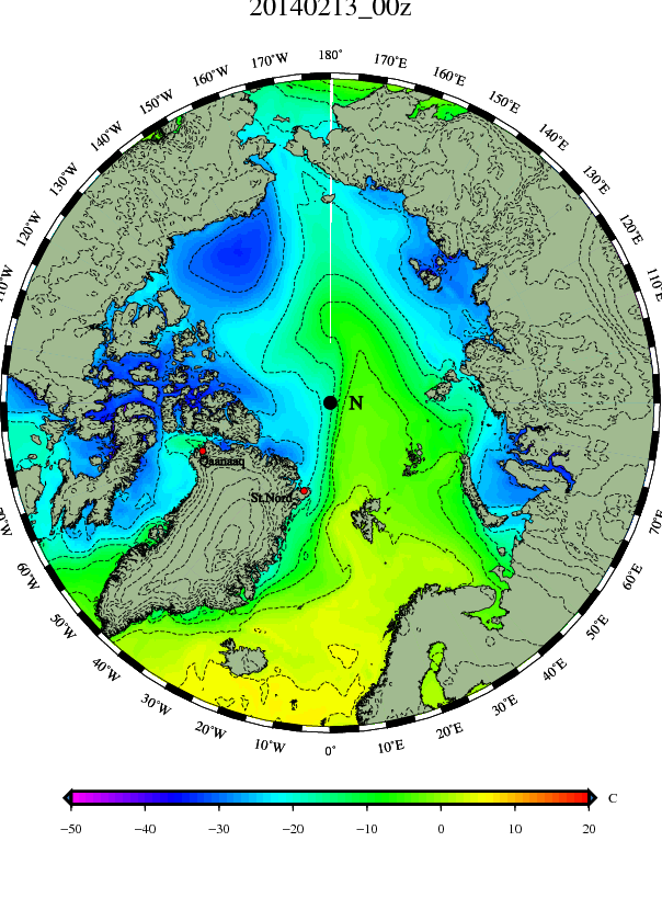
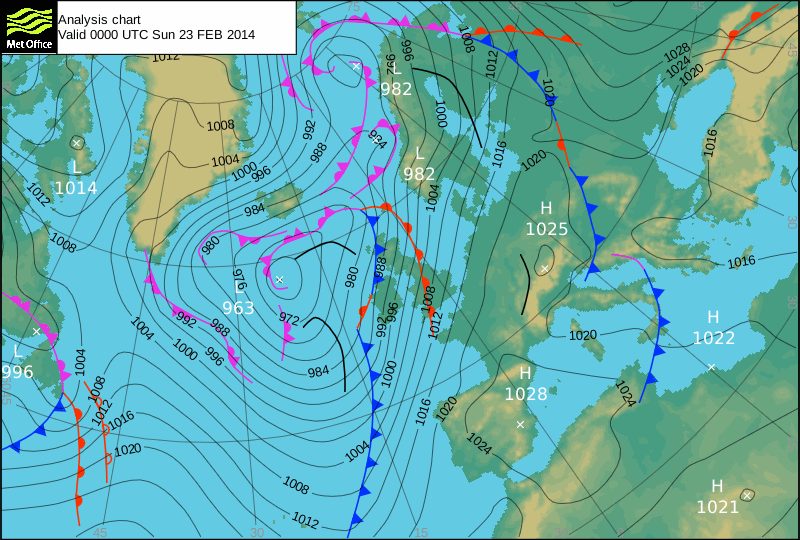
FEBRUARY 24 —DMI MORNING MAPS—

DMI Feb 24 pressure mslp_latest.bigDMI Feb 24 temp_latest.big (1)

FEBRUARY 24  —DMI AFTERNOON MAPS—

DMI Feb 24B pressure mslp_latest.bigDMI Feb 24B temp_latest.big (1)

“Polo” has drifted off the Pole towards Canada, as an extension of the Icelandic low probes north of Scandinavia. It looks a little like an attempt to recreate the autumnal storm track along the Siberian coast, though of course the Kara and Laptev Seas are now frozen over.

A rather impressive slug of very cold air has been delivered into northern Canada.

A QUICK GLANCE AT THE UK MET MAP

UK Met Feb 24B 12561390 (CLICK TO ENLARGE)

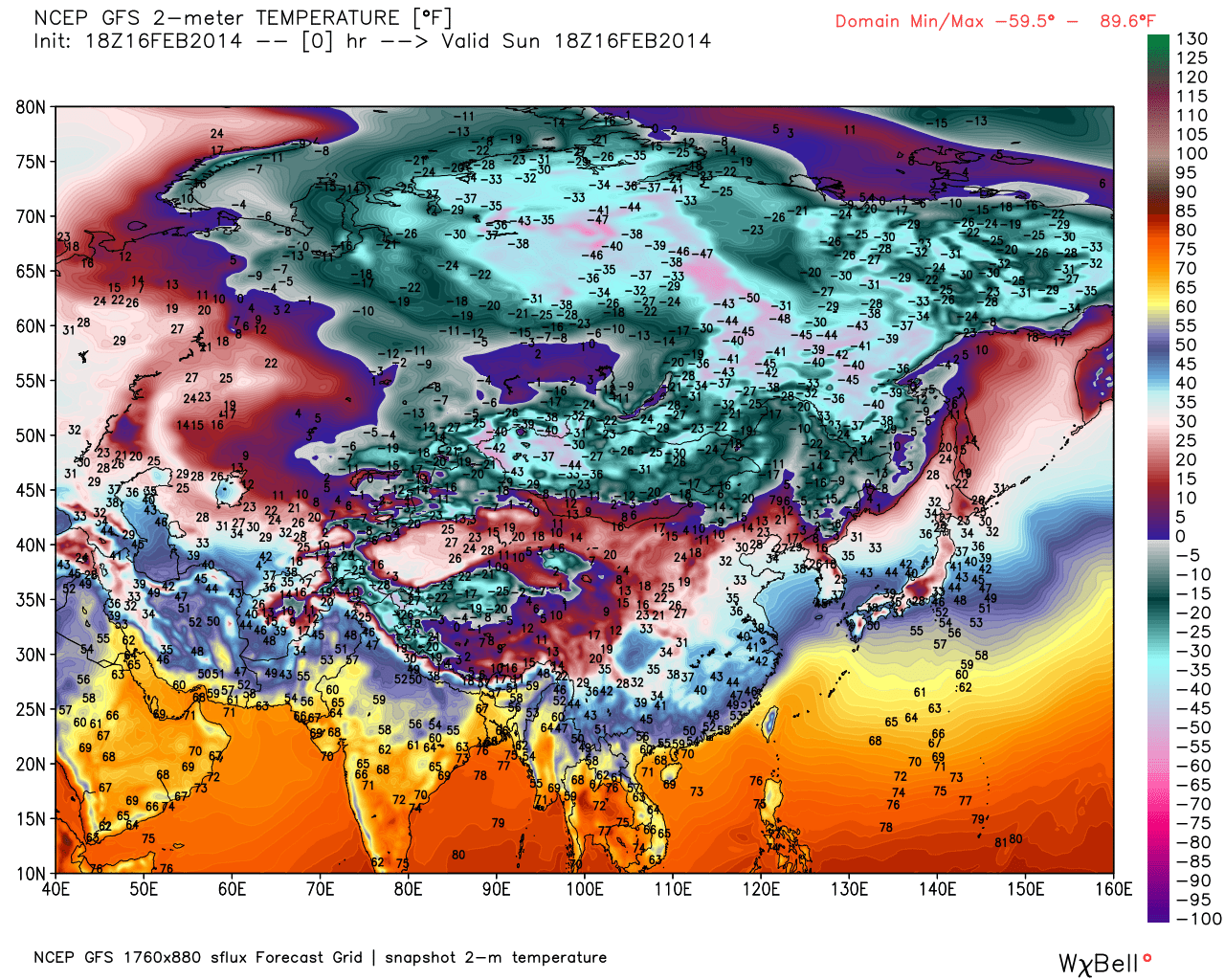
Very cold air is coming south down the coast of Greenland as mild air heads north up the coast of Norway. The boundary between the two is unclear on this map, but clear if you look at the isotherms. Perhaps a better front should be drawn in. Nature is drawing it, with the string of low pressure systems from the Atlantic up into Barents Sea.  These lows are drawn as occluded remnant lows (that I had names for, “Kwik” and “Skwishzip,”) but are too persistent to be purely remnant.

The only new low is “Thotson,” which has scooted across the Atlantic south of the remnants, but now will stall and loop-de-loop west of Ireland, southeast of Iceland, in a position more like a “Britannic Low” than an “Icelandic Low”

“Thot” himself, which was a major North American Feature south of Hudson Bay and North of the Great Lakes, is now a weak low west of Greenland, but its tertiary low will appear at the lower left and become more of a Labrador Low than an Icelandic Low, perhaps held west by Thot’s  dent in the upper atmosphere. This new low, “Thotertiary,” will combine with the stalled “Thotson,” and beneath the two a long fetch of westerly winds will cross the Atlantic.  When these winds reach Europe they will be asked to do an abrupt, hairpin turn and join the south-to-north flow, but may not be able to make the sharp turn, and may go crashing through the guard rail,  creating a southern storm track into the Mediterranean.

In other words, some influences are trying to create a storm track north of Norway as others try to create a storm track through Spain. I doubt the two can coexist.

It is also interesting to note on these maps how often the southeast displacement of the Icelandic Low, creating the Britannic Low, create winds that blow across the Gulf Stream. This may push the warm surface waters south.  Or perhaps the storms that keep blowing up as they approach the British Isles suck the heat out of the water. Or perhaps both. In any case that water’s temperature has gone from being above normal to below normal, this winter.

LOCAL VIEW  —The bluster is back—

Today was one of those miserable Mondays that make men want to ban the day from calenders. Yesterday we had strong west winds, but it still was thawing, though you could feel the edge coming back to the wind.  The radar map showed a front which hadn’t existed had come into  existence right across the USA:

A battle 123 satsfc (3)A battle 123 rad_nat_640x480

(These maps can be clicked to enlarge them)

Towards the end of the day I headed over to the farm to tend to the goats, and noted the show-shedder roof had done its job, and shed the snow. This makes huge heaps in front of doorways, so I had to do yet more shoveling, to dig slots through the heaps of snow. However when I was done I felt confident I’d face a Monday when I didn’t have to shovel. Wrong.

The snow-shedder roof over the main entrance of the Childcare has such a shallow pitch that, rather than shed the snow all at once, like an avalanche, it tends to slowly ooze snow off the edge, like toothpaste from a tube, giving you plenty of time to carve it away as it overhangs the main entry, and giving the children much to be fascinated by, as it forms a slow curve, moving the speed of a glacier, beside the main entrance. Or that is what happened other years.

This morning,as I arrived at work, consciously vowing to stay serene even though it as a Monday, I was confronted by a three foot tall heap of snow in front of the main entrance, as the snow-shedder roof had waited until I departed the day before, and then dumped a winter’s worth of snow onto my nice, clean, dry walkway.  Nor was it fluffy, powder snow. It was compacted slush, frozen to a crust three inches thick at the top. I couldn’t dent it with a snowshovel, and had to go running for a round-nosed garden shovel. My vow to stay serene was utterly shot.

Then there followed an embarrassing and frantic time of hacking away at frozen crush, and digging at slush that stuck to my shovel, as early arrivals had to be escorted to the kitchen doorway, and the children had to be told to stand by the front window and watch me, so I could watch them as I shoveled.

And then the first snow squall hit.

A battle 124 satsfc (3)A battle 124 rad_ne_640x480 (1)

On the weather map you can see our nice westerly flow abruptly became northerly, as the low I dubbed “Thotertiary” started to blow up to our northeast. On the radar map you can see some decent lake-effect squalls blew south off the still unfrozen parts of Lake Ontario to out west, but doesn’t show our local squalls, as they were from low, tumbling clouds that flew beneath the radar like stealth bombers. Some were white clouds and the snow flew in the gusty wind even as a brilliant sun shone, but others were deep purple and the world would briefly look like the middle of a blizzard, and the roads were coated with white.

Ordinarily I enjoy intense flurries, but I had to drive to the last of a series of appointments at my dentist, and then had to drive back roughly a grand poorer.  Furthermore, smashing through a pothole did something to my exhaust pipe, and my old truck now sounded like a hot rod. It  all combined to make me less than appreciative of the winter wonderland I was a midst.

One thing I don’t understand is why visiting a dentist should be tiring. All you do is sit in a comfortable chair,  and my dentist is a good one, and practically painless. However I always wind up feeling like yawns could dislocate my Novocaine-numbed jaw, and I could sleep for a week. Instead I had to restock the porch with firewood and then get sand and spread it where the slush had refrozen and turned a path to the upstairs entry into a lawyer’s delight. I would have put that sanding off, but my wife was fighting the onset of cabin-fever by holding one of her wonderful dinners for staff and parents. So I had to attend that as well, and attempt to be charming as the Novocaine wore off. And then I had to tend to the goats, and my goats are in a bad mood about the weather turning colder.

But now at long last Monday is over, and I can sit back at my computer and have some fun, looking at maps and trying to guess the neck hay-maker life will deliver at me.

A battle 125 satsfc (3)A battle 125 rad_nat_640x480

You can see “Thotertiary” is getting deeper as it departs stage right, to appear on the UK Met maps, and the radar map shows another northern-track feature south of the Great Lakes, headed this way, though the north winds may push it south of us. However these northern-track features don’t scare me much, as even when they explode on the coast they are often heading away, like “Thotertiary,” and even if we get snow it is powdery fluff.  What worries me are the southern-track storms, especially  when they “phase” with the northern-track storms.  For example, that front-less low over Georgia may want to join up with the patch of snow south of the Great Lakes, and prove that the sum can be greater than the total of the two parts.  (Because both are so weak, I don’t expect much, but I’m keeping an eye on them.)

What concerns me is that low over Georgia looks like a harbinger of a whole series of southern-track storms of increasing size.  If you look west you can see another in north Texas, another in southern California, (with a lot of moisture to its south), and lastly an impressive swirl out in the Pacific.  These feaurures tend to crash into our west coast, giving California much needed rain, and to roll across the USA like bowling balls,  largely divorced from the northern storm track until, sometimes with astonishing speed, they “phase.”

If that should happen I’ll look back on this Monday, and with the rosy glasses of 20-20 hindsight, think of how lovely the white flakes were, swirling in the sun, and how nice it was I could drive all the way to the dentist and back without skidding once.  For I’ll be out behind my snow-blower in two feet of heavy wet snow. And, if I could look at this day that way then, I might as well do it now.

FEBRUARY 25 —DMI MORNING MAPS—

DMI Feb 25 pressure mslp_latest.bigDMI Feb 25 temp_latest.big (1)

The Pole is starting to export cold down to Canada, and also down the east coast of Greenland,so I expect temperatures up there may rise a little, as the air is replaced by milder Atlantic and European Continantal air via the Barents Sea entrance region, and also  to a lesser degree by Pacific air via Bering Strait.

While the stripe of high pressure across the Pole does have its own circulation, it also represents blobs of heavy Siberian air pressing down as it moves from Siberia across to North America.  Europe and China can breath easier to see this air head away, and can sit back and snicker at Canada and the USA and even northern Mexico, as this year is their turn to shiver.

“BLACK HOLE” SWIFTLY SHRINKING

I checked out the True Color Arctic Satellite Image and was surprised to see how swiftly the circle of darkness is shrinking over the Pole. It makes sense, when you think that in only 26 days the sun will peek over the horizon at the Pole, and for six months there will be no circle of darkness at the Pole at all.

Despite the fact areas are often obscured by clouds, I highly recommend returning to look at the sea-ice from above on a regular basis. There is nothing like using your own eyes.

One thing I noticed right away was that the parts of the Beaufort Gyre now reappearing show signs they were stressed and did fracture, last winter. While it was not as dramatic as last year, you can see the signs. The old cracks have refrozen, and are various shades of milky white, while the fresh cracks are much darker, nearly black. Each crack represents a patch of sea water that was dramatically cooled for a while, until the ice reformed.

What you can’t see are the smaller features, such as whether the ice is smooth or jumbled slabs. I really wish I could fly around up there in an airplane, (preferably in a heated cabin.)

It remains cold for a while even as the sun peeks above the horizon. It takes a while for the real summer warming to set in.

LOCAL VIEW —Pressing cold—

A battle 126 satsfc (3)A battle 126 rad_nat_640x480

It sure was nice to open our Childcare this morning, and to look east, and see the sun above the horizon.  True, the sun did look like it was shivering in the blustering winds and single digit temperatures, but it wasn’t that long ago I was opening in the dark.

The map shows the first  “threat” is moving out to sea to our south. At worst we’ll get a few flurries, which is fine with me.  The next “threat” is that snow over Nebraska, and the moisture coming across Mexico into Texas from the Pacific. I don’t really see how that can come north, when I look towards the top of the map and see isobars showing north winds from Labrador to Montana. It looks like the entire North Pole is flooding down this way.

Oh well. Take it one day at a time, I suppose.  And today I see what I can do about my ridiculous junker of a truck. I hit a pothole and knocked the exhaust-pipe from the muffler. I wake half the town now, driving to work. Not that I mid that; I’m paying many back for times they hit potholes and suffered the same embarrassment.

What really gets to me is look of reproach I get from my dog, as it sits beside me in the cab. That dog has a most expressive face. Usually it likes the music on the radio, though classical violin music makes it look very sad. This new noise makes it wince, though it still wants to come along for the ride.

I could go on about my experiences with junkers, but I don’t want to be one of those old men who repeats himself. I wrote about hitting “One Pothole Two Many” nearly a year ago: https://sunriseswansong.wordpress.com/2013/03/15/one-pothole-too-many/

FEBRUARY 25 —DMI AFTERNOON MAPS—

DMI Feb 25B pressure mslp_latest.bigDMI Feb 25B temp_latest.big (1) (CLICK TO ENLARGE)

The Icelandic Low seems to be separating from what we could call the Barents Sea Low, which could lead to an interesting shot of cold from Svalbard to Norway. Also it looks like the pool of cold over the Pole is heading towards Canada as one huge blob..

A RAPID APPRAISAL OF THE UK MET MAP

UK Met Feb 25B 12587197  (CLICK TO ENLARGE)

“”Thotson” has become ensconced in the position of the latest “Britannic Low.”  The high pressure bulging off Greenland to the north is deflecting cold air across the Atlantic towards Norway and the British Isles. Meanwhile cold air is trying to sneak west under the high in the upper right, over Siberia. However at this point it doesn’t look like these two cold thrusts will be able to penetrate the mild air between and link up.

“Thotertiary” to the lower left will stall and fall apart, and never make it across the Atlantic, but will kick its fronts east and they may stir up future storms which models show passing under England and crashing into France or even shooting tight into the Mediterranean.

LOCAL VIEW  —Second threat—

A battle 127 satsfc (3)A battle 127 rad_nat_640x480

The second “threat” is heading east. Though it is weak both in the northern and southern branch, it may “phase” as it moves off shore, and give us around an inch as it moves away. There could be a messy commute for people down in NYC tomorrow morning.

Bright sunshine with a few cumulus and stray snow flakes today. I beat down a path for the goats on Saturday, leading across the pasture to the edge of the woods, as the goats don’t like walking in deep snow. Today I led them up that path so I could chainsaw them down a birch tree, as they are sick of their diet of hay and grain, hay and grain. They crowded so close behind me I had to yell at them back off so I could start the chain saw. Then they panicked and started crowding back down the path, rudely pushing each other off the path. It was at this point they discovered the crust on the snow is so thick they can walk on top of it. They celebrated. I have seldom seen such prancing and cavorting, except when the grass is first green in the spring.  The deep snow has been cramping their style, and they apparently are euphoric about being able to do something besides trudge.  (They liked birch branches, as change in diet, as well.)

LOCAL VIEW  —Worry if you will—

A battle 128 satsfc (3)A battle 128 rad_nat_640x480

It makes me a bit nervous to see so much juice down on the coast of the Gulf of Mexico, with two innocent-looking lows approaching us, one in the northern branch north of Lake Ontario and one in the southern branch over Carolina. With the water so warm off the coast, it is as if a lid is taken off the convection as soon as the lows get off shore, and I’ve seen innocent-seeming lows get big very fast.

I peeked out at the pre-dawn darkness, not staying on the porch long as it was a frigid 2 degrees out, and was reassured to see the brilliant stars.  However when I poked my nose out later to see if I could see Mercury peeking over the horizon in the dusk, it has clouded over.

I like to stay down to earth, and note things such as smoke from chimneys, but it was fairly calm. Perhaps there is a slight drift from the southeast. However I decided to consult things that are above my head, and peeked at Dr Ryan Maue’s WeatherBELL map of the 500 mb level of the atmosphere:

A battle 128 gfs_z500_sig_noram_5  (Double click to fully enlarge.)

This is definitely above my head. At WeatherBELL Joe Bastardi states you should heed the “tilt” of the trough. If it leans to the northeast it is a “positive tilt”, and everything presses east out to sea, but if it leans back to the northwest it is a “negative tilt”, and storms can dig in and hug the coast and bomb out.  However my eyes can see both in these isobars. It depends which isobars you look at. The 940 mb is marked in red, and tends to be the focus of many, and to me that one looks indecisive. Like a politician it says, “Maybe positive; maybe negative; see me later.”

I don’t have time for that. I suppose I’ll just keep an eye to the sky and my ears to the forecast updates.

FEBRUARY 26  —DMI MORNING MAPS—

DMI Feb 26 pressure mslp_latest.bigDMI Feb 26 temp_latest.big (1)

It is interesting how that Barents Sea low now has a life of its own.  Hope to find time to focus on what’s up with that, later today.

LOCAL VIEW  —A lunchtime look—

A battle 129 bsatsfc (3)A battle 129 rad_nat_640x480

Just a quick check to see if any “phasing is going on. It isn’t. The moisture is sliding out to sea well to the south, as a cold rain over the Carolina’s.  (Hmm. That might make a good title for a book: “A Cold Rain Over the Carolina’s.”  I’ll get right to work on it.) (As soon as I’m done my chores….which is basically never.)

It’s a cold and blustery day, with only a handful of snow thrown into the wind now and again like sparse confetti. It is keep-your-head-down weather, though there is something about the hint of brilliance in the March-like sunshine that gets you poking your head up just the slightest bit, like a turtle from its bomb shelter, before the all-clear.

FEBRUARY 26  —DMI AFTERNOON MAPS—

DMI Feb 26B pressure mslp_latest.bigDMI Feb 26B temp_latest.big (1)

The Barents Sea Low, which I suppose ought be dubbed “Kwik” as it seems to be the remains of that old storm, weakens but persists, it has built a weak ridge of high pressure between itself and the Labrador-Icelandic Low to the south. This creates a flow from Norway back towards Greenland, and through the Denmark Strait between Greenland and Iceland, to the south, while to the north there apparently is a reverse flow from Greenland east to Finland and western Siberia.  The ice in Fram Strait must be confused, and perhaps is moving east towards Svalbard rather than south.

It will be interesting to watch Kwik. It may be reinforsed by some pockets of mild moisture and become a low like “Polo” was, that wanders about the Pole and creates a sort of zonal flow, and allows temperatures to again drop up there.  This would give me a brief respite, down here in the northeast USA, from the amazing arctic flow we have witnessed, however if the pattern persists the next reservoir of cold air would again dump down over Canada and the USA.

Judging from this view the milder southerly flow over Europe diverges over northern Scandinavia, and doesn’t thrust towards the Pole with vigor. Rather half turns away east and then southeast, while the other swerves west and then southwest.

A RAPIDLY CROSS-EYED APPRAISAL OF THE UK MET MAP

UK Met Feb 26B 12614187  (CLICK TO ENLARGE)

As Usual, the Icelandic Low refuses to establish itself in any sort of lasting manner. Thotson, which was in the best position to accept the crown, is weakening, and Thotertiary, which was in the best position to be a successor, is hanging back like a Labrador Low.  Thotertiary is kicking ahead its fronts to annoy the Irish and English, who have had what Anthony Holmes described as “six months of autumn.” (IE rain after rain, with very little snow.)

Below Thotertiary is a strong westerly flow, with a slight tilt to the south, which seems likely to sweep North American storms more towards France and Spain than towards Iceland. The little storm appearing in the lower left was Threat One in my “Local View,” so I’ll dub it “Thretwan.” It will be interesting to watch it, and see if it defies tradition and actually passes south of the British Isles.

The high to the upper right is not the “Snout of Igor” I expected, as it ingested and holds too much modifying air, and isn’t as cold as I thought it would be.

FEBRUARY 27 —DMI MORNING MAPS—

DMI Feb 27 pressure mslp_latest.bigDMI Feb 27 temp_latest.big (1)

A QUICK LOOK AT THE UK MET

UK Met Feb 27 12626396

LOCAL VIEW  —Dry and cold—

A battle 130 satsfc (3)A battle 130 rad_nat_640x480

LOCAL VIEW  —snow squall line—

A battle 131 satsfc (3)A battle 131 rad_ec_640x480

LOCAL VIEW  — A brief whirl of white—

A battle 132 satsfc (3)A battle 132 rad_ne_640x480 (1)

It was interesting how the arctic front faded after sunset, in some ways like a line of summer thunderstorms. It shows you that the sun is now high enough to stir up even an arctic air-mass.  We did get a brief squall as it came through, and a quarter of an inch dusting.

Built a fire for the children out by the skating pond. Lacing up skates in the cold wind does a number on my old hands.  Also I had to rush off to deal with a bank that does not seem to to care if it loses me as a customer. (They’ll be sorry when I’m rich.) However the day was redeemed by a country garage that fixed up my old truck’s starter and muffler for about a third of what a dealership would charge. I’ll take my small victories where I can find them.

The pines are roaring up on the hills tonight. There is a “wind chill warning” issued.

FEBRUARY 27 —DMI AFTERNOON MAPS—

DMI Feb 27B pressure mslp_latest.bigDMI Feb 27B temp_latest.big (1)

“Kwik” is weaker, northeast of Svalbard, but seems likely to be reinforsed by some mild air working up the west coast of Norway.  A Pacific Low I’ll call “Rongweh 7” is moving the wrong way along the Siberian coast. There is not the same joining of Pacific and Atlantic mildness across the Pole that there was 2 weeks ago,  though this does seem to be a meeker version of the same atmospheric stunt. The Pacific invading air is already chilled, even from what it was this morning, and a new wave of “Igor’s” cold seems to be moving off the coast of eastern Siberia.  My impression is that we might get a brief break from the arctic onslaught, here in North America, but then it will resume.

A SWIFT SCAN OF THE UK MET MAP

UK Met Feb 27B 12639897 (Click to enlarge)

“Thotertiary” continues to hang back like A Labrador Low, and now is weakening, as “Thotson” wobbles up towards Iceland, also weakening. In the westerly flow beneath the two occluded gales “Thretwan” is making a beeline towards the south coasts of Ireland and England. No surprise there, unless it is that the coast may just get clipped ratherbthan clobbered.  “Thretoo” is making an appearance at the lower left, and at this point looks like it will make a beeline in Thretwan’s wake. These storms are crossing far enough south to start pushing a storm tack into the Mediterranean.

Over Europe the winds continue from the south, but that stubborn high pressure east of Scandinavia is starting to push back, and introduce some east winds into the equation, especially in eastern Europe.

FEBRUARY 28  —DMI MORNING MAPS—

DMI Feb 28 pressure mslp_latest.bigDMI Feb 28 temp_latest.big (1) (click to enlarge)

LOCAL VIEW  —Zero at daybreak—

A battle 133 satsfc (3)A battle 133 rad_nat_640x480

The wind roared during the night, but is fading as the horizon brightens with orange. It is zero, (-17 Celsius,) and dry as a bone. Even when it “warms” to 20 this week the dew points are down near zero. However the real news is that the dust is finally getting dampened in Southern California.  That pulse of moisture will roll across the USA and may make headlines when it crashes into  the cold air.

LOCAL VIEW  —Snowman’s sunglasses—

A battle 134 satsfc (3)A battle 134 rad_nat_640x480

I tend to drive my wife crazy by living too close to the edge. She likes to arrive early, but to me that is wasted time.  I squeeze every last second from my dawdling, and then rocket out the door to do whatever it is I have to do. In terms of opening up the Childcare, I like to charge about and then pretend to be serene, as the first customer arrives and I unlock the front door.  Only occasionally does this efficient use of every available second come back to bite me, as it did last Monday when I arrived to find three feet of snow had slid off the roof and blocked the entry.  (Then I have to fall back on my charm.)

Lately I have become less efficient, as I keep arriving early. This inexplicably aberrant behavior is due to the dawn messing up my biorhythms. I tend to be checking out weather maps on my computer until a certain tint of the eastern sky rockets me out the door.  With the sun rising nearly two minutes earlier every day, in only five days I can go from being punctual to being ten minutes too early.

Twice a year daylight messes with your mind this way, and the confusion is heightened by the landscape being so utterly different.  Today the day is eleven hours and eleven minutes long here, the same as it is on October 13, but in October the trees are only starting to change, and the ponds are still unfrozen, and while frost may have killed the squash and tomatoes and corn and peppers, there are still beets and broccoli, kale and carrots and cabbages, parsnips and parsley and potatoes to pluck from the soil. Now the soil is rock hard beneath a sweeping stretch of white, and considering humans are creatures of habit, it is little wonder we feel perturbed, as if something isn’t quite right. Days don’t break the same.

Glittering stars, with bitter black breezes, are broken by a sudden streak of blue along the eastern rim, as Spring teases hope into hardened eyes, not because you feel any kindness in the stinging gale, but rather because morn taps your shoulder and you check your watch.

Deep darkness grows pale earlier each dawn: White page from dark folder, new day unwritten-upon arises earlier. Earlier ends dark brooding. The inevitable isn’t. Surprises shock the pessimist with hope’s mood-swing, and all of this unexpected delight smiles because more daylight’s in sight.

Even my cat gets crazy, as usually it winces and will not step out into sub-zero cold, but this morning it went out and just sat in the sun, despite the cold. It sensibly turned and came in after five minutes, but those five minutes hint at the start of March madness.

It is no coincidence that the two holidays we dedicate to pranks and tricks are situated when daylight is messing with our minds. The trick-or-treating of Halloween is a bookend to April fooling.

True, April first is still a long month away, but already I can see that the first sign of Spring is not a robin. Instead it is happy insanity.

FEBRUARY 28  —DMI AFTERNOON MAPS—

DMI Feb 28B pressure mslp_latest.bigDMI Freb 28B temp_latest.big (1)

“Kwik” has come back to life, after nearly fading away, and is rebuilding the weak ridge of high pressure between Norway and Greenland that to some degree walls the Atlantic influence away from the pole. The north winds between Kwik and Svalbard might even be cold enough to grow a swift skim of ice on the edges of Barents Sea, which doesn’t mean all that much as it will be melted away in days, or at most a few weeks, however in terms of the politics surrounding sea-ice it means a great deal and will cause all sorts of hoopla.

The past few years we have seen the ice keep expanding past the time when it usually hits its peak. This has been seen with great consternation by Alarmists, and as a reason to rejoice by Skeptics. Actually it is six inches of HTGT ice that matters little in terms of the big picture, and likely barely causes the slightest blip in terms of the stratification of seawater and its temperature. However it has happened, and it will be interesting to watch and see if it happens again.

Meanwhile I’ll be watching Kwik to see if it has the effect Polo had, and creates a semi-zonal flow around the Pole which causes temperatures to plummet at the very top of the globe, right when Siberia’s increased daylight is reducing its effectiveness as the Northern Hemisphere’s refrigerator.

A SPEEDY SQUINT AT TWO UK MET MAPS

UK Met Feb 28 FSXX00T_00UK Met Feb 28B 12667187 (CLICK THESE MAPS TO ENLARGE)

These maps show “Thotson” weakening while doing a poor impersonation of an Icelandic Low. Thretwan has scooted just south of England into France, somehow failing to bomb out and ruin the weekend for the British Isles with drenching rains and howling winds. :Thretoo and Thretree are weak in its wake, and are likely to pass too far south of the Isles to spoil the party.  Interestingly Thretfor, just appearing to the lower left, which was little more than a squall line when it passed my farm on this side of the Pond, may well be the next Britannic Low, but it won’t be able to spoil the weekend, as it likely won’t get across until Monday.

The high pressure to the upper right, east of Finland, is forecast to gradually shift the winds over Europe from south to southeast and finally east, as it just sits there for the next five days.  A hugely simplified schematic would show, by Tuesday, a northern flow from the Black Sea to the Baltic and on to Baffin Bay, and a southern flow from  Newfoundland Island to France to Turkey.  (We are unlikely to see anything so simple develop.)

LOCAL VIEW  —Dry cold to end?—

A battle 135 satsfc (3)A battle 135 rad_nat_640x480

If you include yesterday’s arctic front and squalls of snow, we have had four “threats” pass us by with little more than a dusting, or a handful of flakes on a brisk breeze. Today we didn’t even get that; it was the first day without a flake in days. It was cold and amazingly dry. When dry air comes in your house, and you heat it from zero to sixty-five, it is parched air, air that is drier than most deserts. We have a pot of water on our wood stove to keep the air from withering us, and on days like today it is amazing how swiftly that pot empties without boiling. Evaporation is extreme when the relative humidity is five percent.

The above map shows that the fifth “threat” will likely also pass us by, with the northern branch failing to “phase” with the southern branch, and the snow over the Great lakes being little more than another dry, arctic front when it gets here. However by then the sixth “threat” will be hard on its heels, full of California rain-clouds, and it may ram its moisture into that arctic front.

Moisture.  What a nice word.  It’s been a while since we last heard the trickling of rain off the roof. Not that we’ll get rain. That arctic front all but guarantees us snow.

MARCH 1  —DMI MORNING MAPS—

DMI Mar 1 pressure mslp_latest.bigDMI Mar 1 temp_latest.big (1) (CLICK TO ENLARGE)

“Kwik” continues to whirl up near the Pole, over Franz Josef Land, drawing a tendril of milder, moister air up to its east, but sweeping cold air down to its west past Svalbard and over Barents Sea. The Atlantic is being cut off from the Arctic by a weak ridge of high Pressure south of Svalbard, turning the winds around the weak “Thotson,” (between Iceland and Norway,) around so they blow east from Norway to Greenland, rather than up into Barents Sea. However the Pacific is invading to a greater degree through Bering Strait and north of Alaska.  The cross-polar-flow has been interrupted, at the surface at least.

A BRIEF BLINK AT UK MET MAP

UK Met Mar 1 12680295  (CLICK TO ENLARGE)

“Thretwan” has occluded and stalled across the Channel in Belgium, kicking its energy southeast to the Mediterranean. “Thretoo” and “Thretree” are weak in its wake, and are likely to be little more than occlusions as they pass over Ireland, also kicking energy southeast. “Thretfor” is brewing up a Labrador Low southwest of Greenland, which is likely to cross the Atlantic, again farther south, and to try to become the next Britannic Low.

To the north “Thotson” and “Thotertiary” continue to swirl weakly, doing a poor job of being an Icelandic Low. It appears more Atlantic moisture is heading southwest between Iceland and Greenland than is getting up to the Arctic past Norway.

What is most intriguing to me is the gradual tilt of the flow over mainland Europe to the southeast, due to the high east of Scandinavia. This should eventually import very dry air from the Steppes. Though cold, it won’t be true Siberian air.

TRANSPOLAR DRIFT NORMAL FOR A CHANGE

Drift mar 1 arcticicespddrfnowcast (click to enlarge)

This map shows ice moving across the Pole and through Fram Strait in the textbook manner. What is interesting to me is how often the flow has refused to take this route and do things by the book, over the past year.  If you watch the animation of the past 30 days you can see the ice often moved against the flow: http://www7320.nrlssc.navy.mil/hycomARC/navo/arcticicespddrf_nowcast_anim30d.gif

The current flow may bring about a spike in the extent maps by closing the open water north of Svalbard and clogging Fram Strait and the coast of Greenland south to Denmark Strait. (Also cold air may create HTGT ice on the edges of Barents Sea.)

Also the current flow may create a channel of open water along the arctic coasts of Alaska and Canada, which may inflame the aspirations of mad sailors to attempt the Northwest Passage this summer. It doesn’t seem like a good idea this year, as that channel along the coast is like the jaws of a crocodile. If the wind shifts to the north the ice returns south, and the jaws close.  The ice is far thicker and denser to the north than it has recently been.

LOCAL VIEW  —ANOTHER SUBZERO MORNING

A battle 136 satsfc (3)A battle 136 rad_nat_640x480

Five below zero, even though it is March.  When I went for my morning coffee neither the hot nor cold kitchen faucet worked. Therefore I started my day under the sink with my wife’s hair drier.

One good thing about old copper pipes is that they conduct heat well, and I don’t have to squirm around in the crawl-space beneath that kitchen floor. After a couple minutes I had the water running.  Still, it was noteable that those pipes froze, not only because it is Match, but also because the snow is deep around the house, and usually that insulates the crawl space. However perhaps the snow shrank down enough, on the south-facing side.

This winter hasn’t been all that bad, in terms of the worst cold. I can recall a cold wave (1994?) when it got down to minus-27 (-33 Celsius) and, even with three wood stoves burning, I had the kids sleep in the living room rather than their icebox bedrooms. That was one time that a 250-year-old house’s charm was lost on me. This winter the coldest it has been is minus-9 (-23 Celsius,) but the cold has had a persistence that stands out.  Even our yo-yo mild spells, which we got because we are on the eastern edge of the national cold, only thawed the top of the snow, which then quickly refroze.

One odd thing I noticed yesterday was that the surface of the farm pond was actually higher than the edge, in places.  Over and over the warm-ups created layers of wet slush atop the ice, which refroze. Meanwhile the ice grew down at the bottom of the ice, until it is now nearly three feet thick. And because a tenth of an iceberg floats above water, the ice has lifted three inches at the outlet, and is three inches higher than the outlet without flowing out.

Hmm. If the ice all melts at once in a warm rain, we could get quite a spring freshet this year, especially because the ground was frozen deeply early in the winter when there was little snow, and the water can’t be absorbed by the ground until that semi-permafrost melts. However we won’t cross that washed-out bridge until we come to it.

The above map still looks quite dry to me, despite everyone talking about a storm on Monday.  Another amazing mass of cold air is pressing south, and it wouldn’t surprise me if this next threat was shunted south of us.  That is fine with me.  Let Washington DC do a bit of shoveling, for a change.

MARCH 1 —DMI AFTERNOON MAPS—

DMI Mar 1B pressure mslp_latest.bigDMI Mar 1B temp_latest.big (1)

MARCH 2   —DMI MORNING MAPS—

DMI Mar 2 pressure mslp_latest.bigDMI Mar 2 temp_latest.big (1)

“Kwik” has joined with low pressure pushing through Bering Strait to create a sort of backwash to recent cross-polar-flow, with isobars suggesting winds coming back from Canada.  This doesn’t show very well on the isotherm map because as soon as air gets over the open water of Barents Sea it is warmed at the low level the isotherms describe.  Only two meters above the open water the air is swiftly warmed, though the water is  swiftly cooled.

This backwash looks to be a brief event, with the flow again reversed by tomorrow, as Kwik weakens and the lobe of low pressure between Svalbard and Greenland strengthening into a new low, again separate from the Atlantic, which I guess I’ll call “Sval,” as it is developing right next to Svalbard. This will create isobars which suggest a flow again from Siberia to Canada. (Currently that flow is from far east Siberia across the Bering Strait to far west Alaska, but will rapidly expand as Kwik weakens and the flow on the Atlantic side of Kwik  vanishes, and reappears south of Sval.

Sval  looks to be the last of  these small polar lows that are independent of the Atlantic. Models now suggest a major flow will surge north up the coast of Norway from the Atlantic, as a storm comes up the coast of Greenland, to the west of Iceland. This is very different storm-track from the current pattern’s, which has storms heading east well south of Iceland. It will be interesting to watch.

LOCAL VIEW  —snow staying south?—

A battle 137 satsfc (3)A battle 137 rad_nat_640x480

Milder, with a dust of snow this morning. A very cold arctic front is approaching, likely with another dusting, however at this point it looks like the bulk of the following snow will be pushed south of us by the arctic front.

LOCAL VIEW  —Finding sweetness in bitter blasts—Scripture and squirrels

A battle 138 satsfc (3)A battle 138 rad_nat_640x480

A southern band of snow does seem to be increasing as the northern band decreases, which does suggest the storm will slide south of us.  Fine with me. If I don’t have to spend time cleaning up heaps of snow I have more time to entertain the kids at my Childcare, (and hopefully a few observers of this blog, as well.)

I checked out the WeatherBELL site to see what Joe Bastardi and Joseph D’Aleo had to say about the coming cold, and they didn’t hold out much hope for warming. In fact some models suggest the core of the cold will shift east, and rather than Minneapolis and Chicago getting the core of the cold, it will be the northeast. In fact, as I squint at the maps, the exact center of the cold looks like it is located in my back pasture.

Oh well, I suppose things have to balance out. A couple of years ago the soil thawed early and  I actually got my peas planted around the first day of spring.  This year it looks like it is likely to be the more traditional time, which is “Patriots Day,” on April 19. (And I can remember planting peas midst whirling snowflakes, even on April 19.)

In any case, it will be a wait. Sometimes the waiting and waiting and waiting for spring gets people down, especially when the frozen ground gives way to “mud season,” where the top four inches thaws above frozen earth, and water cannot drain away, and life gets downright sloppy.  Even indoors-people get discouraged, because the mess sticks to feet and mud tracks indoors, despite the best efforts of housewives to battle it back at the front entry.

I try to be sensitive to my wife, and to remove my boots a tenth of an inch inside the front door, but so invasive is the mud that it uses that slender foothold to spread like butter over toast throughout the entire house.  I spread my palms in incredulous disbelief when my wife points to evidence in far corners of our abode that I was careless. I have no idea how mud got onto the ceiling of the bathroom. It is just one of those things that happens, during mud season.

And, as if a husband isn’t bad enough, my wife must also deal with a hoard of small children at our Childcare.  Seventeen small children translates to  thirty-four feet, all spreading mud like butter-knives over toast. This is not merely discouraging. It is tantamount to a spiritual crisis.

I should be able to handle a spiritual crisis, as I am a deacon at my church. True, I only became a deacon because, as Christianity has become politically incorrect in New England, membership declined to a degree where they had to employ me, even though I confess to being more focused on being a good cantankerous anachronism than on being a good Christian.

The way a cantankerous anachronism handles a spiritual crisis is through a wry sense of humor. While the Bible never actually comes out and states a wry sense of humor  is a spiritual gift, I see it in the scriptures. For example, in Galatians 5, verse 12, Paul is basically stating that if people think circumcision of the foreskin is so spiritual,  he wishes they would be even more spiritual and cut their entire penis off. If that isn’t a wry sense of humor, I don’t know what is.

Around these parts, when people are suffering from a long, long winter, one thing we have done in the past, to fight off the spiritual depression of a long, long winter giving way to a long, long mud-season, is to hold a “talent show”, where people can express a wry sense of humor. I think the last time we did this was in the last century, around 1996,  when we suffered a winter which simply refused to quit. That doesn’t seem so long ago to me, but time has flown, and, somewhat to my amazement, there are now very young mothers who were not even born, the last time we had a mud-season talent show.

The idea popped into my head that this winter was so hard and so prolonged that now was high time for another mud-season talent show.  My pragmatic side was screaming, “No, no, no!  That would be extra work!” However, in a most careless manner I “floated” the idea, as a deacon of a very small church. I didn’t think the idea would catch on.  It was just an old-fashioned idea of an old-fashioned, anachronistic geezer. However the idea did catch on, and now I’m stuck with it.

I was sort of hoping everyone would forget I ever mentioned the idea, but this morning, as I came dashing into the church at the last possible moment, despite the fact I am “deacon on duty” and obliged to stand at the pulpit and begin the service with the “announcements,” I glanced up towards a big screen I don’t much like, which my church has plastered up on the wall above the pulpit in an attempt to be “modern.”  (The most recent invention I, as an anachronism, approve of is the invention of stained glass.) On that screen was the blaring announcement: “Talent Show!”  Then, in the small print, it stated, “See Caleb Shaw for details.”

As I sauntered up to the pulpit to begin the service I was attempting to think fast. My brain did not comply. As I announced the other church activities I was troubled by a troublesome detail. That detail was that people could not “see me for details” about the Talent Show, for I hadn’t worked out any of the details. I had merely floated an idea. Now I suddenly found myself in charge of an event, and in some ways Master of Ceremonies of an event, which only moments before I had been hoping everyone would forget I ever mentioned.

In the end I was honest, and simply stated there were still “a few details to work out.” However, on the way to that honest confession, I babbled a bit. In fact I reminded myself of Calvin, in the old “Calvin and Hobbs” cartoons, when he was asked for homework, or an answer, by his battle-ax teacher, and was “buying time,” for if he procrastinated long enough the bell would ring and he could escape the classroom without answering or producing homework. Unfortunately no such escape was available to me, for, in a very small church, I, as the deacon who announces the announcements, am also the deacon who, just after that, rushes to the bell rope and rings the bell.

During the time I babbled a bit, my mouth produced some wonderful sidetracks, including the weather report.  I discussed the reasons for a talent show, avoiding the subject of the talent show itself. I discussed how cold and dreary and, in the end, muddy, the month of March could be. I found myself discussing ways the monotony and dreary boredom of waiting for April could be relieved, besides holding a talent show. Among other things, I babbled about snapping the twig of a maple tree to grow an icicle of maple sap.

I cannot say where that idea came from. Blame it on the Holy Spirit, if you will. In any case, as I looked out over the mostly empty pews, I could see the scattered congregation was looking at me with obvious interest, as I babbled. Apparently they had never heard of growing your own maple syrup Popsicle.

What happens is that, when you snap a maple’s twig in subfreezing temperatures, perhaps due to the power of the sun on the south-facing side of the maple’s bark, the sap flows even though it is below freezing. When you interrupt this flow on its way to a bud, by snapping a twig, the tree bleeds just as we bleed from a small cut, but as soon as the sap hits the air it freezes, forming an icicle. Then, because the air is so extremely dry, a process called “sublimation” occurs, where ice becomes water vapor without the bother of melting. (A bit like “dry ice”, which is CO2 and cannot exist as liquid at ordinary sea-level barometric pressures.) What this does is shrink the icicle, and reduce the amount of water in it, which increases the amount of maple sugar.  On occasion the icicles from a maple tree’s broken twig can be surprisingly sweet.

I’m not sure if this has anything to do with Christianity. Perhaps, in a symbolic sense, it may explain how an anachronistic old icicle like me wound up a deacon. Sweetness is found in unexpected places.

In any case, no one got mad at me for the fact I haven’t worked out the details of the talent show. But I’ll have to get busy.

After church I got curious about who first discovered the sweetness of maple icicles, and decided to research the subject.  Apparently the credit goes to a red squirrel:

Red-Squirrel-1

(credit also goes to the photographer Allan Oman, whose site is at:  http://allanoman.photoshelter.com/image/I0000yMZQ8Rsmf2w )

In conclusion, if you want to find sweetness in a World man has made more bitter and cold than it needs to be, there are two places to find sweetness: Scripture, and squirrels.

MARCH 2 —DMI AFTERNOON MAPS—

DMI Mar 2B pressure mslp_latest.bigDMI Mar 2B temp_latest.big (1)  (click to enlarge)

“Sval” failed to develop, but right where models thought he would move, a weak low has swung around along the Canadian coast from the Bering Strait. I guess I’ll call it “Rietway,” because it came the right way rather than the wrong way. It may well be a fleeting feature, but it has allowed the cross-polar-flow to resume in its wake.

The wall of high pressure continues to segregate the Arctic from the Atlantic, and for the time being ice sxtent should be growing in Barents Sea. Models suggest the Atlantic will mount an invasion by midweek.

A GALLOPING GLIMPSE AT TWO UK MET MAPS

UK Met Mar 2 FSXX00T_00UK Met Mar 2B 12720117  (CLICK THESE MAPS TO ENLARGE)

“Thretfor” has become a powerful storm, and is not heading up to Iceland like a good Icelandic Low, but is following the pattern and is heading straight towards the British IsleS to give those poor, drenched people a blue Monday.  However at least they got a shred of a decent weekend, between showers.

Models are flip-flopping all over the place, concerning a coming change.  The most extreme “solutions” have the next trans-Atlantic storm completely breaking the pattern, and heading straight north rather than straight east, and rather than passing well south of Iceland passing well west, up the coast of Greenland. However that is only one of a number of different “solutions.”

Things have got to change, because the seasons are changing, however I have a “rule,” (though at times it seems more like a “superstition,”) that you can sometimes learn how the next winter will begin by how the last winter ended.  I am watching the current maps keenly, for clues.

Those who have visited this site during the duration of this winter know I have been on guard for the east winds from Siberia, and for situations to become like the map below.

A A Screen shot 2013_05_19 at 10_33_10 PM(1)

In fact, if you look at the above UK Met maps you can see elements of the above “AO and NOA negative” map, with a storm track into the Mediterranean and the winds over Europe shifting to the east, however time and time again we would approach this “solution,” only to swing the other way. In fact the true pattern this winter has been to be between two patterns, neither here nor there, which is why I think we may have discovered a third pattern.  It is a sort of illegitimate bastard pattern, as it does not have an authorized and official name, but it sure does plunk a gale over the British Isles with annoying (to those people) regularity, which is why I decided to give the bastard legitimacy, and called it “The Britannic Low.”

My curiosity now wonders, “Will we begin next winter in this pattern, or will a new pattern evolve?” My hunch is: A new pattern. Therefore I am watching the end of this winter for hints.

LOCAL VIEW —The seventh threat—

A battle 139 satsfc (3)A battle 139 rad_nat_640x480

Last Friday some of the older kids at our Daycare confided to me that they expected their vacation would be extended a day by a snowstorm tomorrow, but it looks like they will be disappointed.  The amazing (for March) press of arctic air seems to be pushing everything south. Threat-number-six basically evaporated, the air was so cold and dry, (though a remnant storm “Thretix” may ripple onto my UK Met discussion tomorrow.)  The seventh threat may well also be squeezed south of tomorrow.  In fact I am planning on it.

However,until the storm moves out to sea, I’ll reserve judgement, and retain my option for worry.  (I learned how to worry from my mother, who had an amazing capacity for fretting about things happening to me that never happened.) (Also the American Prophet Yogi Berra is said to have once pronounced, “It ain’t over ’til it’s over,” which is especially applicable to the above maps.)

The worrisome aspect of the above maps is the warmth coming north in the east as the cold swivels south in the west.  This suggests the seventh storm could tilt the table, becoming bigger than expected.  The forecasts are based on things staying “flat,” but the radar shows the warmth has come north far enough for rain in the south of New Jersey, even as plunging cold amazes the northern panhandle of Texas. (In one north Texan town, where the average high temperature for this date in March is 67, the actual high was 7; a mere sixty degrees below normal!!!) (Meanwhile, on the southern coast of Texas, it was 87 degrees.  That is an eighty degree contrast, and able to dumbfound computer models built upon “averages.”)

In a worst-case-scenario this seventh threat, (which I dub “Threteven”), would become bigger, dig deeper, and move slower. This would then cause it to dig even more, deepen even more, and slow even more.  Rather than being a big but “flat” system, moving to our south and giving Washington DC snow, it would give them more rain, as it tilted the tables and rode a retreating arctic front north. I would wake tomorrow to winter weather advisories, which would become winter storm warnings around noon, resulting in local schools closing early, and our Childcare experiencing total chaos and confusion, and, all things considered, a typical Monday.

I prefer to imagine it will be an atypical Monday.  Nothing unexpected will happen. The day will break steely grey, with the storm passing south of us, and the winds will stay from the cold and dry northwest.  Temperatures will refuse to rise, even when the sun pokes through in the afternoon, and the high temperature will be seventeen.  In that cold I will thank the skies for dryness, and the fact I don’t need to remove snow. Instead I’ll focus on tapping maple trees, even though it will be so cold no sap will flow.

MARCH 3  —DMI MORNING MAPS—

DMI Mar 3 pressure mslp_latest.bigDMI Mar 3 temp_latest.big (1)

LOCAL VIEW  —Storm slipping south— 

A battle 140 satsfc (3)A battle 140 rad_ec_640x480

MARCH 3  —DMI AFTERNOON MAPS—

DMI Mar 3B pressure mslp_latest.bigDMI Mar 3B temp_latest.big (1)

“Sval” has formed over Svalbard, and is drifting up towards the Pole, likely to absorb “Kwik” and “Riteway” and to create a very brief period of semi-zonal flow. It will be interesting to watch how much mild Atlantic air Sval brings north, and how quickly that air cools.

Some models are showing a huge area of low pressure completely surrounding Greenland by Thursday.  There can’t truly be a low center over the icecap, but the 996mb isobar will surround Greenland and also much of the north Atlantic.

UK MET MAP

UK Met Mar 3B 12746096

“Thretfor” has parked over the British Isles and become the Britannic Low, as expected, while kicking low pressure down into the Mediterranean storm track.  “Thretix” is crossing and will likely take a southerly route, but is leaving energy behind as a Labrador Low which will be interesting to watch, as it is expected to grow and engulf Greenland. Talk about morphistication! In some ways, with shreds of the typical icecap high pressure at the center, it will be like the low is a whole bunch of lows around Greenland, like the petals of a daisy.  The lows moving up Greenland’s east coast could get pretty big and bring a surge of south winds up towards the Pole, with the southerly flow stretching clear across to Norway.

LOCAL VIEW  —grey day—

A battle 141 satsfc (3)A battle 141 rad_nat_640x480

The seventh threat was the biggest, and held the most potential and power, but it too slipped off the coast to our south, and all we got of it was a grey day.  Temperatures had dropped to twelve by dawn, and barely rose all day. The kids didn’t want to play outside much. The snow has all turned to a gritty crust, and I can walk atop a foot of snow as if I am as light as a squirrel.  I’m not.

It was a tedious sort of day, and I’m in the mood to turn in early.  I’ll let the maps speak for themselves.  (Get talking, maps.)

MARCH 4  —DMI MORNING MAPS—

DMI Mar 4 pressure mslp_latest.bigDMI Mar 4 temp_latest.big (1)

“Sval” swirls up by the Pole, creating a bent flow from Finland east along the Siberian coast to the laptev Sea, where it takes a left turn and is a cross-polar-flow to Canada. This creates a flow with a split personality, as it has two source regions. Milder air comes from north of Europe, while Siberian air is pulled up from central Asia. I wonder if the clash between these two stripes of air will make Sval stronger, or influence his track.

No sign of the flood of air up from the Atlantic yet.

LOCAL VIEW  —SKIES GONE MILKY—(The Medusa Effect)

A battle 142 satsfc (3)A battle 142 rad_nat_640x480

It was another bitterly cold morning. As I opened the door at the Childcare for a parent loaded down with her child’s supplies, I saw her glace at the thermometer,  which read three degrees.  (-15 Celsius.)  Brightly and cheerfully I stated, “Well, at least it is above zero. That’s a sign of spring for sure!”  She managed a chuckle, just barely.

However as soon as the March sun got up in the spotlessly blue sky, you could feel the warmth in the rays.  Temperatures fought up towards twenty, however if you got on the south side of a building out of the wind you could bask, and even see the snow soften and slump a little.  But then the slightest overcast came over, and immediately the world turned back to stone.

This is an amazing start to March. In March hot and humid air usually comes north from the Gulf of Mexico, and we get our first tornadoes in the Midwest as it clashes with polar cold. The above radar map shows snow down on the Gulf Coast. Unbelievable!

That southern snow is a southern-branch feature hardly getting notice on the map, and the snow over the Great lakes is a northern-branch feature equally undignified with attention. Together they represent “threat eight,” which is not much of a threat, though it does turn our blue skies milky, and our landscape back to stone, like a wink from Medusa.

MARCH 4  —DMI AFTERNOON MAPS—

DMI Mar 4B pressure mslp_latest.bigDMI Mar 4B temp_latest.big (1)

This is a very interesting couple of maps. (To me, at least.)

For one thing, as “Sval” has gobbled up “Rietway” and “Kwik” he has become a decently strong low on the Pole.  Imagine that!  With all the talk of Polar Vortexes, in an attempt to explain every arctic outbreak, we now have a vortex on the Pole, which likely will get no press whatsoever. True, compared to what is brewing down around Cape Farewell at the southern tip of Greenland, it is a small low, but the isobars are tightly packed on the Suberian side of the Pole, and you can bet winds are strong and the sea-ice is getting crammed into the Beaufort Gyre, rather than down towards Fram Strait.

Second, look back at the maps for the past few days, and contemplate what has become of the mild Pacific air associated with “Rietway.”  Unless a little got sucked into the top of Baffin Bay, it has all been ingested by the development of “Sval.”  Just compare the isotherms from the morning map of two days ago with today’s afternoon map:

DMI Mar 2 temp_latest.big (1)DMI Mar 4B temp_latest.big (1)

That entire pool of mild air has been transformed into cold air.  Magic?  We are talking the green hues turning to deep blue, or -8 degree air changing to -25 degree and even -30 degree air.  Not magic, but fact. (Likely the warm air rose, lost heat to outer space, and showered down snow.)

Third, notice the tongue of “warm” air “Sval” is now sucking up into its core from Barents Sea. (This contains a lot of air from the Steppes, and isn’t true Atlantic juice.) Will the same “magic” aflict this mild air, dropping its temperature 20 degrees in sixty hours? STAY TUNED!!!

Lastly, watch that low south of Greenland. It may engulf all of Greenland, and then even grow bigger.  Indeed it may become this thing called “A Grand Planetary Wave,” wherein the polar, sub-polar and sub-tropical waves all match up, and you can get a gigantic plunge in the isobars forming a trough from west of Greenland to the Gulf of Mexico. Such events are rare, and likely won’t happen, but tend to happen this time of year when they do happen. If it happened people in Europe could sit back and munch popcorn, watching the USA cuss and tantrum and shovel feet of snow.

Even if that doesn’t happen, you can see a decent cross-polar-flow is redeveloping, which makes warm spells highly unlikely on this side of the Pond.

LIGHTNING-LIKE PEERINGS AT UK MET MAPS

UK Met Mar 4 FSXX00T_00UK Met Mar 4B 12773405  (Click these maps to enlarge them.)

These maps show the mixed muddle of switching patterns. “Thretix” is taking the old patterns southerly route towards the Mediterranean track, as “Threteven” appears and seems hesitant, and even divided, with part following along behind on Thretix’s cold front, as a northern part has independent fronts and is getting sucked into a deepening of isobars at the southern tip of Greenland.

This sort of confused map messes with the virtual mind of models, (and the very real minds of true meteorologists as well.)  Until a new pattern becomes clear you are likely to get a wide variety of “solutions” from the models, (and a variety of forecasts from true meteorologists as well.)

One very interesting solution has the deepening south of Greenland becoming a major feature, even to the degree where it may suck some warm air way down at the bottom right of the map from the Azores right up towards England. (Such a visit of balmy temperatures would likely be part of a showery pattern, if not yet another gale, but balmy is still nice, even if it is brief.)

However until such a Greenland-engulfing feature actually manifests, other solutions are still on the table. In any case, I wish I had the time to really study these maps, rather than watching from afar. Some intriguing stuff is going on.

AN UNEXPECTED THANK-YOU

This is pretty neat, for me at least.

I likely sound like an advertisement for WeatherBELL, but I do get all sorts of wonderful information for the price of a cup of coffee each day from their “Premium Site.”  So I headed over there this evening to see what was new, and got my socks knocked off by this headline on Joe Bastardi’s blog: THANKS CALEB, FOR AT LEAST LISTENING

So of course I wondered, “What the heck?”  Then I read on. (I would link you to his site, but you may not have the price of a cup of coffee.) Joe wrote:

“March 4 04:06 PM

I was glancing through WUWT at an article about Dr Jeff Masters and his comments on how this winter is a sign of global warming. I came upon this letter and I want to say thank you to Caleb for remembering the theory behind all this. Essentially if the oceans caused warming and they started turning colder, there would be some climatic hardship, nothing too terrible in relation to what has happened before, but something that was at least there to consider.

“Caleb says:March 4, 2014 at 7:44 am 

Back when I first started paying attention to Joe Bastardi, nearly a decade ago, he was warning we should expect to face what he called “a time of climatic hardship.” His warning was based upon prior weather, and what occurred the last time the “warm” PDOand AMO flipped over to the “cold” phases. His warning didn’t involve Global Warming one bit. It only needed history to repeat itself.

I imagine he got laughed at a bit, as back then the talk was all warming followed by more warming, and how our children weren’t going to know what snow looked like.

Now the PDO has flipped to the “cold” phase, and we are waiting for the AMO to also flip in the next few years. So far Mr. Bastardi looks wise and the Alarmists look like….well, unwise.

At this point the Alarmists are flip-flopping like a trout on hot tar. They need to be reminded, over and over and over, of what they said in the past. Not that they will ever say the three very difficult words, “I was wrong.” Being able to say those three words is the sign of a true adult. Flip-flopping, on the other hand, means you’re up to something fishy.”

I took alot of heat over this, alot of ridicule. And by the way there is no way to say if its truly right or wrong as far as a provable point. The main message is that as long as there were clashes , the weather was likely to produce extreme events. It seemed to me that with the PDO flipping and the amo warm, and then flipping later, we should look to what happened before.

If there was no clash, if one side overran the other, there would be LESS extreme weather. That is a fact of nature.. When one side overwhelms the other, be it the weather or a wrestling match, the weather goes from chaos to lack of chaos.. in the case of wrestling, the match ends.

I realize such things are a threat to people who want others to believe that this is so complex, you have no chance to understand it. But I have found, through watching all of you, whether you like me or not, its the opposite. I have found there alot of very talented people out there that if their path was different, their love of the weather and the talent they have would have them on the same path I am on. This does not threaten me, it makes me grateful that I had the chance. A letter like this makes me understand what a blessed man I am .

So Caleb and all of you, thanks.

Now, is that not a fairly nice thing to blunder across? (I should note that when I wrote that comment on WUWT I had no inkling Mr. Bastardi would ever see it.)

What was even better was to look through his next post, and to see he had examples of “Grand Planetary Waves.”  The first is from March 13, 1993, and is from a situation I fondly remember, because I was younger and stronger, and the resultant storm created so much shoveling I made a quick hundred dollars at a time I sorely needed it.

Grand Planetary Wave compday_J5CFf_N3Nq (click to enlarge)

The second map is from a computer model, for the exact same day, 21 years later:

Grand Planetary Wave gefs_z500a_noram_37(1)  (Click map to enlarge.)

Considering I am 21 years older, I doubt I would be as fond of the same situation, if it reoccurred.  (By the way, which map is superior? The old one, or the Dr. Ryan Maue WeatherBELL map?)

As a final example of sounding like a WeatherBELL commercial, I’ll steal something from Joseph D’Aleo’s blog at WeatherBELL, however this one deserves its own headline:

GREAT LAKES ICE SETS MODERN (SINCE 1980) RECORD

I could hunt down this map and the pictures of Niagara Falls for myself, but why do that work when Joseph D’Aleo works so hard to make it available to me?

Great Lakes March 4 lice_00  (CLICK TO ENLARGE)

Great Lakes March 4 1960830_10201192157760688_23307115_o  (CLICK TO ENLARGE)

‘UNPRECEDENTED?’ NOT SO FAST.  NIAGARA IN 1911

Great Lakes March 4 1911  (CLICK TO ENLARGE)

I am sorry if this post seems like some sort of mushy mutual-admiration-society. However the reason is that I admired both Joseph D’Aleo and Joe Bastardi even before “WeatherBELL” existed, back when I made Bastardi my professor at “Accuweather” and heeded D’Aleo through his site at “Icecap.”  I’ve been thanking them for a decade, and even if I didn’t get tonight’s return thank-you, I’d go right on telling everyone I know that their site, and Dr. Ryan Maue’s maps, are worthy, because the simple fact of the matter is: That’s the truth.

Now let me toot my own horn. If you look way back in these posts you will see I had what I called a “hunch” this winter would be a bad one, and backed up my statement by buying several truckloads of firewood. Now it seems, with propane prices above $4.00 a gallon at times, I was not as dumb as I look (and often behave.)

The Great Lakes are not a small body of water, yet are not included in the “Sea-Ice extent graphs,” for the obvious reason they are not salt water.  However, if you include them in the surface area of the planet, they make a blip in the data as big as the Baltic Sea. The Baltic Sea is below average this winter, but if you included the Great Lakes in the sea-ice data, it might more than make up for that deficiency.

In other words, even if it is mild in Europe, this is no slouch, as winters go. And it isn’t over.

LOCAL VIEW  —We duck another bullet?—

A battle 143 satsfc (3)A battle 143 rad_nat_640x480

As an old geezer, this map makes me nervous, however when I check my weather-radio I learn we have a 40% chance of snow-showers tomorrow.  No prediction for snow amounts is made, which suggests a dusting at best.

Why am I nervous? Because the ingredients for worse are there. You have a northern-branch low with a big arctic high sitting over it, and a low in the Gulf of Mexico with plenty of juice.

Even if threat-eight slips harmlessly out to sea, I can’t help but wonder, “How many times can we duck the bullet?”

My hunch is that we will get at least one, big, storm-to-remember, before this winter quits.

MARCH 5  —DMI MORNING MAPS—

DMI Mar 5 pressure mslp_latest.bigDMI Mar 5 temp_latest.big (1)

“Sval” is becoming the northern appendage of low pressure engulfing the entire island of Greenland.

LOCAL VIEW  —Another gray day—

A battlke 144 satsfc (3)A battle 144 rad_nat_640x480

We were at seventeen (-8 Celsius) this morning, which felt surprisingly warm.  Gray overcast sliding over from the west, as low gray scud came in from the east, with light snow falling. Even the snow looked a bit gray to me.

Temperatures are suppose to get down to five below (-20 Celsius) tonight, which doesn’t have my mood very spring-like.  We might make it up to freezing by Friday.

MARCH 5  —AFTERNOON DMI MAPS—

DMI Match 5B pressure mslp_latest.bigDMI Mar 5B temp_latest.big (1)

“Sval” has weakened while drifting towards Canada from the Pole, pulling a tendril of mildness with him, as a part of a cross-polar-flow which continues strong even as Sval weakens, due to the powerful low developing at the southern tip of Greenland.  I cam going to dub this low “Morphy” because it involves so much of what I call “morphistication.” (Basically morphistication is what occurs to low pressure areas as they transit high ranges of mountains.)

There tends to be a semi-permanent high pressure parked over the cold ice-cap of Greenland, but Morphy is erasing it. Atlantic air is slamming into Greenland, being hoisted over 10,000 feet as it crosses the icecap, having lots of moisture condense and crystallize and produce available heat from latent heat as the snow snows out, and then a sort of Greenland Chinook occurs as this air sinks more than 10,000 feet from the icecap to sea level on the Baffin Bay side.  Although the Chinook has “warmed” air, a lot of heat is lost to outer space as well, and my guess would be the process represents a loss of heat, even though the Baffin Bay coast may experience a short term warming of sorts. (This would be a neat thing to study more deeply. When I’m filthy rich I’ll hire some brilliant young student to study what happens to winds transiting Greenland.)

For the time being the milder Atlantic air is hitting Greenland rather than invading the Arctic, but it does look like an invasion is immanent.  It will be interesting to watch this invasion, and see how it mixes with the cross polar flow.  It looks like Morphy will dominate the Atlantic side, and high pressure dominate the Pacific side.

A RAPID SCAN OF THE UK MET MAPS

UK Met Mar 5 FSXX00T_00UK Met Mar 5B 12798082

I’m tired, and am mostly popping these maps in here hoping I have the time to study them later. You can see the old storm track continuing to feed weak trans-Atlantic lows into the Mediterranean, even as Morphy grows and takes over the show. O guess I’ll call that appendage of Morphy getting wheeled past Iceland “Morpheven”, as it took over the cold front belonging to “Threteven.”

Watch the Azores High at the bottom center to see if some really balmy air can make it north, and watch the lobe of Siberian high pressure over Finland to see if it can bring cool and dry air from the Steppes west on its south side. Some sort of conflict between the two high pressure areas seems likely.

LOCAL VIEW  —2 inches of fluff—

A battle 145 satsfc (3)A battle 145 rad_nat_640x480

Even as the cold, dry air moved in all day, just enough of a easterly drift continued at the surface to give us light snow all day, with the flakes getting large and thick just before it ended at dark. I wasn’t feeling very inspired, but did manage to get the kids at the Childcare involved with catching snowflakes on there tongues.  As I showed them how the thought occurred to me, “Dang. It’s been years since I’ve done this.”

I’d also forgotten how white flakes look like black ashes, when you look up into a grey sky, and how the flakes expand towards you as they fall, and how the farthest flakes look like a thick swarm of the smallest black gnats.

That low lurking in the Western Gulf of Mexico is Threat Nine.

MARCH 6 —DMI MORNING MAPS—

DMI Mar 6 pressure mslp_latest.bigDMI Mar 6 temp_latest.big (1)

“Morphy” is impressive as it engulfs Greenland, with “Morpheven” being swung past Iceland. Strong southerly flow developing over Norway. The Scandinavia-to-Canada cross-polar flow should create a milder stripe than the Siberia-to-Alaska flow.

A HASTY HEEDING OF THE UK MET MAP

UK Met Mar 6 12811230 (Click to enlarge)

The Azores High has actually linked with the Siberian High, forming a weak wall of high pressure between the old pattern, with lows in the Mediterranean, and the new pattern, with “Morphy” creating a Icelandic High that is displaced northwest rather than southeast over England. In fact it looks like southeast England might even be close enough the high pressure over France to see a thing called sunshine.

The front touching northeast Ireland and Scotland will not move east greatly, becoming a feature on the maps that undulates back and forth over the British Isles and the coast of Norway over the next few days, separating a milder southwesterly flow from a colder southwesterly flow.

LOCAL VIEW —The last sub-zero daybreak of the winter?—

A battle 146 satsfc (3)A battle 146 rad_nat_640x480

Fresh snow-cover bred a pocket of nasty cold in our area, especially down in valleys.It was seven below (-22 Celsius) at the foot of our hill, as I stumbled about in the dark getting going. When I went out to start my wife’s truck for her the east was just starting to get light, but even that was annoying because, just when we are starting to have a glimmer of daylight to work with, the dolts in Washington DC decree that the clocks should spring forward to Daylight Savings Time, an hour earlier than they used to, which means we’ll be working in the dark again next Monday.

I didn’t think I needed gloves just to walk to the truck and back, but the cold stung the back of my hands immediately. It wouldn’t do to start the day crabbing about everything, so I stuck my hands deep into my pockets and looked around for something inspiring.

The east blushes blue. A cardinal tweets, insanely loud in the subzero hush.  Jaunty red plumage black against dawn, he greets winter’s conquest with counter-claims, a rush of twitters, and then, “Tweet! Tweet! Tweet!” he yells: A winced headache to all with hangovers and a plague to sleep. “Tweet! Tweet!” It compels curses from virgin lips; even pushovers push back against the madness of claiming a white waste of tundra for a dull spouse who likely thinks he’s mad, and is shaming him by basking in Florida.  What house can he claim for her when the odds are so low?  “Tweet! Tweet!” screams the cardinal at seven below.

I decided I likely needed a second cup of coffee.

Cardinal images

***********

The sun has risen in a cloudless sky, and by 9:00 AM its beaming face is as high as it is at noon in December. Temperatures have risen 30 degrees, which is still ten below freezing, but feels kindly in the calm. Despite some murmuring about a big storm next week, last night felt like the peak of ice in the depth of winter, and so this seems like a good place to end this post.  However I should add an ice-extent graph, to show its peak as well.

DMI Mar 6 icecover_current_new (Click graph to enlarge.)

I imagine this is the peak of the ice extent because late season increases are largely HTGT ice along the edges, especially in the Barents Sea, and that sea is likely to see a decrease in strong southerly winds, the next week.

Barents Sea is the main reason the extent looks low this year.  It has less ice this winter than any time in recent history:

DMI Mar 6 region.all.anom.region.6 (click graph to enlarge)

My assumption is that this is typical of the situations that develop when the AMO is about to switch.  It may even be a cause of the AMO switching.  It will be interesting to see if having this water unprotected by ice all winter speeds the ice-melt or retards it. (It will make no difference to the minimum, because Barents Sea nearly always melts completely.)  I wrote more about this wondering in an essay called, “Author Of Its Own Demise.”  https://sunriseswansong.wordpress.com/2014/01/07/author-of-its-own-demise/

This series of posts will continue at:

ARCTIC SEA ICE MAXIMUM —MARCH MADNESS—

ARCTIC SEA ICE RECOVERY —THE EQUIPOISE OF BATTLE—

This is a continuation of a series of posts, the last of which was, https://sunriseswansong.wordpress.com/2014/01/29/arctic-sea-ice-recovery-the-viewless-viewers-views/

The original post was about the view from the North Pole Camera. I learned some years ago that the view from that camera showed things that the press was not reporting, and became intrigued. Partly the view helped me become an educated voter, and partly it is a serene and beautiful view to watch, especially during the summer when the weather is hot.

Now the cameras all have been either retrieved, shut-down, or lost at sea. I am a viewer without a view. Even the visible satellite pictures show a black hole of darkness at the Pole during the winter. However I had become engrossed and, partly because I simply am stubborn, I have continued to observe what I cannot see. I make do with infrared and microwave satellite data.

Two gold mines of information I use are the “Sea Ice Page” on the “Watts Up With That” site, and the thousand or so maps Dr. Ryan Maue makes available at the WeatherBELL. site.

I tend to post the DMI pressure and temperature maps of the Pole twice a day, and any other maps that strike my fancy.  Also I post what I call a “Local View” (which some may wish to skip,) as it is about how the arctic is effecting my little town in New Hampshire, and contains what I call humor and also some purple prose.

If you are a first-time visitor I will simply say this post will get longer and longer, as I add updates to the bottom several times a day. If you revisit the site to check up on the latest update you can enter on my home page, and click the little “comments” balloon to the right of the title, and that will take you to the bottom of the post, where you can scroll up a short ways to see the latest. This avoids the bother of sometimes needing to scroll down a long, long ways to see the latest.

We are now nearing the point where ice is approaching its maximum extent, which is something like the point where a pendulum stops going one way and starts going another. (It is interesting that the word “poise” comes from a word for a weight used back when weighing things was done on an old-fashioned scale. It was a thing rather than a state.) Often “poise” suggests a sort of pause, and a calm.  In truth it is a time of some of our biggest storms, as the higher sun creates warmth at a time when winter is still at its mightiest. It is a case of an irresistible force meeting an immovable object.

The days are swiftly lengthening, and we are starting to see diurnal variation in bone-chilling places like Siberia. True, the temperatures may only rise from minus-forty to minus-twenty at noon,  however still it a hint at a warming sun.

Although the sun is already as high as it was in early November it shines on a completely changed world. In November lakes and bays were unfrozen and still radiated heat remembered from summer sunshine. Now those lakes and bays have become traitors to the heat, and are white wastes that reflect the sun away. As soon as the sun sets at night they become generators of cold, as radiational cooling occurs where, last November, the same lakes and bays wafted updrafts of mildness. The north is still capable of creating cold air masses even as the south creates warmth.

Therefore, rather than less snowy, it can become more snowy. Even as temperatures start to rise from their winter depths, the depth of snow can increase. The extent of arctic sea-ice can increase as well, especially if it is shifted the right way by winds.  (This year a last-minute spike in ice-extent would be most likely to occur if calm and cold conditions occurred in the North Atlantic, where Barents Sea ice is below normal, and also if a surge of ice was flushed south through Fram Strait.)

If snows increase here in New Hampshire I’ll be busy battling it, and updates at this site will become few and far between. However it is actually a sign of the turning of the tide, and of spring.

FEBRUARY 10 —DMI AFTERNOON MAPS—

DMI Feb 10B pressure mslp_latest.bigDMI Feb 10B temp_latest.big (1)

“Rongwe 5” continues across the Pole, now more a part of the Atlantic low pressure than a separate identity. While he is pulling a plume of milder Pacific air in behind, he is going to slam that door shut by swinging a slug of Siberian cold right up into that plume, and then on into Alaska and Canada. The real invasion of mildness is likely to be from the Atlantic, over the top of Greenland, and actually  oppose the circulation of Rongwe 5 for a while.

The isobars diverge north and northwest of Svalbard, pushing some ice down through Fram Strait while pushing ice further north away into the Beaufort Gyre, and keeping it from entering Fram Strait.  It seems only logical that when ice moves in a way that diverges an area of open water should appear. Perhaps this explains the open water northeast of Svalbard, which keeps attempting to freeze over only to reappear.

DMI Feb 10B arcticicennowcast (1) (click to enlarge)

Even odder is the fact that the open water is “below normal,” in terms of sea-surface temperature, while ice-covered areas around it are “above normal,” according to this map:

DMI Feb 10B color_anomaly_NPS_ophi0 (click to enlarge)

The divergent flow can be seen in the map below. Some ice is being sucked down through Fram strait by the winds on the northwest side of the Icelandic Low, but a lot more ice is drifting straight into the Beaufort Gyre.

DMI Feb 10B arcticicespddrfnowcast (click map to enlarge)

FEBRUARY 11  —DMI MORNING MAPS—

DMI Feb 11 pressure mslp_latest.bigDMI Feb 11 temp_latest.big (1)

The low I dubbed “Rongwe 5” is finishing his journey as a bubble carried along by the old cross-polar-flow, and carrying along a last slug of Siberian air to Canada in his wake. However it looks like the cross-polar-flow is swinging clockwise, and moving from a Siberia-to-Canada flow to an Atlantic-to-Pacific flow.  This may give the USA a break from winter blasts, but not until a week-to-ten-day period of Siberian air that has already been delivered gets used up. Meanwhile Europe continues to get a southerly flow except for the very west, which gets storms.

QUICK GLANCE AT UK MET MAP 

UK Met Feb 11 12210115 (click map to enlarge)

What a messy map!  The pattern continues to be stuck between having a strong and established Icelandic Low, and having a storm track through the Mediterranean. Currently it looks like the GFS model was wrong, and what remains of “Lullerthird” will not redevelop and swing a secondary into Norway tomorrow. Rather the weak low “Ghost,” just appearing in the lower left, will strengthen as it crosses the Atlantic and (Surprise! Surprise! Surprise!) crash into the waterlogged British Isles on Thursday.

The pattern I’ve been watching for all winter has been strong on the American side of the Atlantic, but never has really established itself on the European side.  (Likely this demonstrates a Pacific component was involved.)  I still think it may appear, but it is too late to cause Europe a severe winter;  instead it would be a spoiled spring.

A A Screen shot 2013_05_19 at 10_33_10 PM(1)

LOCAL VIEW  —Rumors of storm—

A battle 89 satsfc (3)A battle 89 rad_nat_640x480

The GFS computer models started to see the storm I’ve been wary about last night. As it is the model most of our local forecasts are based about, forecasts had been for a light snow event on Thursday, as the GFS saw the storm slipping out to sea. Last night there was suddenly more  concern, and people picking up their children at our childcare started demonstating that strange glee people have when doom first appears on the horizon, but still is at a safe distance.

I try not to get too caught up in it. Some were all excited about a giant storm that some model showed for last weekend, and talked of us getting two feet of snow, and then had to suck lemons when we only got an inch.  However this time the threat looks realer.

You can see the rain and snow brewing to the south, in the radar map. Some of this will slip out to sea with a ripple of low pressure I suppose is “Ghostson.”  More moisture will hang back and await the kick from that impulse of energy way up in the Canadian Rockies. That energy will swing down and swoop up the Gulf of Mexico moisture and then curl back up the coast, likely giving us snow Wedensday night and Thursday morning.

I’m the slightest bit smug about that front laying down in the Gulf, as it is a ghost-front which came back to life, which I paid attention to, and it is the reason the storm whose isobars are dimly seen in the upper right of the map got the name “Ghost.”  I figure that, even though a lot of this next storm’s energy is coming from elsewhere, it is a sort of “Ghostthird.”  However it is detached from “Ghost” to such a degree I figure it ought be spelled differently, to recognize its separate identity, so I guess I’ll dub it “Gothurd.” (That has a nice, Nordic ring to it.)

It’s a bit below zero out, in the dark of predawn, and as low as ten-below in a sheltered valley down the road. I’m going to be fairly busy with storm preparations on top of ordinary chores, but will post when I can.

FEBRUARY 11  —DMI AFTERNOON MAPS—

DMI Feb 11B pressure mslp_latest.bigDMI Feb 11B temp_latest.big (1)

Just at first glance, (and only glance, as I’m tired,) It looks like Rongwe 5 is the last of the Pacific “wrong-way” storms, but a new parade of Atlantic wrong-way storms may get going along the north coast of Greenland and Canada.

The Finland to Alaska cross-polar-flow is now glaringly obvious, and seems likely to inject less-cold air into at least half the Arctic.  The big blob of cold crossing on the Bering Strait side looks like it will be the last, but we’ll have to wait and see about that. ( I keep thinking patterns are about to change, and then the old patterns resume.)

FEBRUARY 12   —DMI MORNING MAPS—  My back porch is colder than the Pole

DMI Feb 12 pressure mslp_latest.bigDMI Feb 12 temp_latest.big (1)

An impressive surge of Atlantic air is invading the Arctic Sea, as both Iceland and Svalbard experience thawing. Temperatures at the Pole have risen above minus-ten ( 14 Fahrenheit) and could get above minus-five (23 Fahrenheit).  Meanwhile it is minus-seventeen on my back porch (0 Fahrenheit.)

I wish the darn arctic would stay up where it belongs.

I wonder if the clash between mild air and cold air will brew up an arctic gale.  I’m going to name that low north of Greenland “Atwong,” (for “Atlantic-wrong-way-low.”)

The north-of-eighty-degrees-latitude-graph DMI temperature graph will spike way above normal, as all the truly cold air is over towards Bering Strait, or in Siberia, or raising my heating bill, and most is south of eighty degrees.

With low pressure moving west on the Canadian side I wonder if high pressure will move west on the Eurasian side, bringing a “Snout of Igor” (Siberian Cold) back to Europe. I wouldn’t put away my winter clothes, if I lived over there, though looks like it will stay mild until next week.

QUICK GLANCE AT UK MET MAP

UK Met Feb 12 12236347 (CLICK TO ENLARGE)

“Lullerthird” remains strong between Iceland and Scotland, as “Ghost” continues on its way across the Atlantic to crash into waterlogged England. Though the Mediterranean storm track is still apparent the Icelandic High is making a comeback. In western Europe the southerly flow has a maritime-polar source, and isn’t all that warm. In eastern Europe they are getting a break from Siberian air, but the “Snout of Igor” should come surging back in a week or so. Don’t put away your mittens.

LOCAL VIEW  —Insomnia report—  

A battle 90 satsfc (3)A battle 90 rad_nat_640x480

A battle 91 satsfc (3)A battle 91 rad_nat_640x480

The above maps show the warmth people were talking about coming across the USA just got crushed between the preceding arctic high and the following arctic high, and now is an occlusion extending up to Hudson Bay. The real action is to the south, where “Ghostson” slipped harmlessly out to sea (unless you live in the Carolinas,) and now “Gothurd” is gathering strength and looks far less harmless.

The GFS computer model keeps hinting Gothurd might slip out to sea like Ghostson did, but the Weather Service issued a “watch” yesterday and a “warning” about ten minutes ago, so maybe they don’t trust their own computer, or maybe it updated its read-out.

I’m in no mood for a storm. Three separate ailments have been moving through town, (a cold, a 24-hour-stomach-bug, [Norovirus] and the flu). Children and parents at our day care are coming down with things left and right, but my wife and I can’t. Our staff can have sick days, but we have to be immune. Strangely, we (so far) haven’t gotten sick, however I think we simply are exposed so such an onslaught of germs that our immune systems are in high gear, so that when we get things we don’t get completely clobbered.  We just feel less than 100%, but are still able to do stuff that has to be done, such as snow-blow the driveways. However I sure don’t feel like snow-blowing when I am not at 100%.

O well, whatever will be will be.

SIBERIAN SNEAK ATTACK ON WESTERN EUROPE

The following maps are produced by Dr. Ryan Maue at the WeatherBELL site. They show very cold air sneaking back over arctic waters during the next ten days to come down on western Europe from the northeast.  They are from the ECMWF model, and represent whether temperatures are above normal or below normal roughly 5000 feet up from sea level, in the atmosphere. Notice how Scandinavia starts out red (above normal) but winds up blue (below normal.)

Models are often wrong, but this particular model shows a solution which shows something I’ve been thinking about, and is why I think people in london shouldn’t put away their mittens.

(By the way, the map also shows coastal Siberia has exported so much cold to Canada it is now above normal. But don’t be fooled by the red color. “Above normal” is still well below zero.) (Double-click these maps to fully enlarge.)

PRESENT   Sib1 eps_t850a_asia_1

IN 3 DAYS     Sib2 eps_t850a_asia_13

IN 5 DAYS      Sib3 eps_t850a_asia_21

 7 1/2 DAYS    Sib4 eps_t850a_asia_31

IN 10 DAYS    Sib5 eps_t850a_asia_41

FEBRUARY 12  —DMI AFTERNOON MAPS—  Thaw at Pole?

DMI Feb 12B mslp_latest.bigDMI Feb 12B temp_latest.big (1)

The Finland to Alaska cross-polar-flow persists, and has now dragged the minus-five isotherm right next to the Pole, with the freezing-isotherm now poking north of Svalbard.  Considering how tightly the isobars are packed together, it seems remotely possible for above freezing temperatures to cross the Pole, despite ice-cover and 24-hour-a-day darkness. If it happens, I imagine it will generate a counter-attack-headline, to cover the fact that places in the American Midwest are threatening to break all-time records concerning snow-cover and cold.

It’s darn hard to sell Global Warming in the American Midwest right now, just as it was hard in Europe last winter.  Therefore there will be, I imagine, an attempt to change the subject and divert attention elsewhere, by the salesmen.  They have money involved, and it is impossible to be objective and see the big picture when constrained by concerns for the the wallet.

In my humble opinion the big picture is that something is out of balance, and therefore the jet stream has gone loopy.  The atmosphere is always striving to achieve an impossible mediocrity, and the zonal pattern is as close as it gets.  The loopy [or ‘meridianal’] pattern is, I imagine, a sign something needs to be brought back into balance. Perhaps it is caused by the PDO switching to “cold” mode when the Atlantic is still in “warm” mode.  Or perhaps it is caused by the variations of the sunspot cycle.  Or some other cause.  However we are witnessing an atmosphere which is doing some drastic things, flinging cold air far to the south and sucking warm air clear to the Pole, to regain its balance.

Pretty neat, if you ask me. But no reason to raise taxes.

The surge towards the Pole will interrupt the flow of Siberian cold to Canada, I imagine, and it also seems likely to create a new place for that Siberian air to go. Every action begets a reaction, so I imagine the current from Finland to Alaska will create a counter-current the other way, along the Siberian coast from east to west, creating the sneak-attack portrayed in the update before this one.

Lastly, in terms of sea-ice, this flow is not flushing much ice down through Fram Strait, and is cramming a lot of ice into Beaufort Gyre. Though ice extents may drop, the ice that exists in the arctic is not the thin skin it was a couple years ago.  It is compressed, and thicker.

A QUICK GLANCE AT THE UK MET

UK Met Feb 12B 12250227 (click to enlarge)

The pattern seems to be wobbling back towards the domination of the Icelandic Low, as “Lullerthird” has retained its strength despite being occluded, and remains a strong 954 mb gale south of Iceland. Meanwhile “Ghost” is nearly as strong, a 955 mb storm smashing poor Ireland yet again. In a sense this reduces the power of the Icelandic Low, and gives credence to my assertion that this winter we have a “Britannic Low”.

I should also point out that “Ghost” got its name because it was a feature I noted on American maps that didn’t get the notoriety of being noted by the map-makers.  It was a mere dimple in the isobars, without the recognition of a little “L” on the map to show it was there, and its fronts un-delineated, and mere “ghost fronts.”

There are features on this map equally unnoticed.  I will give the map-maker credit for noticing Ghostson, just appearing as a meek thing in the lower left corner, as that will likely be the next gale crashing into Ireland and rebuilding the Britannic Low.

However the persistance of the Britannic Low is creating a divided Europe, for it does not create a kindly southern flow from the Azores, (though occational dollops of that nice air can come north.) Instead it drives maritime polar air into the southern flow. This air may be greatly modified by its Atlantic passage, but it remembers its arctic origins.  While the lowlands of England may be squelching and soggy, the highlands of Scotland are drowning in snow.  Therefore there should be a demarcation in the southerly flow, currently owning Europe. To the east, where it usually is colder, the southerly flow is bringing air up from deserts and warn seas, but to the west, where it usually is milder, the flow has a definite chill, as its origins are Iceland and Greenland.

This chill from the west will be matched by a chill from the east, but that is especially unapparent in this map. All that remains of the “Snout of Igor” is vague high pressure in the upper right, and it seems the antithesis of Siberian cold, because it is the west side of a high pressure and denotes winds from the balmy south.  However as this high pressure lifts to the north the winds will shift to the southeast and then east, and the balmy nature of the wind will change.

Or so I surmise. We shall see what we shall see. All I am saying is that there are features on this map that are not apparent, unless you listen to the whispers of ghosts in the wind.

LOCAL VIEW  —Will the storm stall?—

A battle 92 satsfc (3)A battle 92 rad_nat_640x480

When I was young, this map would be a dream come true, especially with 18 inches of snow in our forecast. It would have meant no school tomorrow, and likely Friday as well, and then all of Saturday and Sunday free as well, before I finally faced my undone homework, late on Sunday night.

Now it only makes extra work for me, and it is amazing how that alters your view of a storm. Rather than a friend it is my enemy. How the tables have turned!

The good news is that the storm has slowed down. The snow was originally suppose to start at midnight, but now it is delayed until after the sun is up. So I don’t have to crawl from bed before dawn, leaving my warm wife for the embrace of bitter winds, and for miserable time spent trudging in darkness behind a snow-blower, so customers can drive comfortably into our Daycare’s lot. Instead I can sleep a little later, and likely won’t have to snow-blow until noon.

My hope is that the storm slows down to a grinding halt.  I’ve seen such things happen in the past.  If you look at the map, the high pressure to the north does present an obstacle. Originally the GFS had that high pressure shunting the storm out to sea, but it has now decided the high will prevent the storm from taking that route, blocking that escape, and causing it to head inland to such a degree Boston will see the snow turn to rain, (even as we get all snow, 60 miles inland and north).  And if the GFS can slow the storm that much, why not go farther?

Once these storm slow they occlude, as a fast-cold-front speeds around the low to a slow-warm-front stretching east. Then the storm follows the occlusion due east, sometimes creating remarkably different weather and snow-totals in a sixty-mile range.

In February 1978 a blizzard, thaw, and blizzard completely shut down Boston, but in the suburbs of Portland, Maine it was just a couple of ordinary storms, and life went on as usual. The only sign things were amiss was that the shelves started to look empty in grocery stores, because no trucks could come north. However enterprising truck drivers drove all the way around and came south from Quebec, and the shelves were restocked in Maine even before Boston had its streets clean.

The entire day of the Perfect Storm in 1991 we, where I now live in New Hampshire, had grey skies and strong winds blowing dry leaves about like scurrying herds of knee-high color, with blue sky at the northern horizon. I drove up to that horizon because I wanted to help out at a friend’s “Habitat For Humanity” project, and actually got a sunburn in October, as fishermen drowned in a crazed Atlantic not too far to my east.

So it has happened before, and can happen again. The GFS computer lives in a dream world, and only comes around to reality as it happens. Slowly it is getting around to seeing the storm doesn’t zip out to sea, and consequently the forecast now has the storm plodding slowly up the coast. Why shouldn’t it just as slowly get around to seeing the storm stop, occlude, and follow its occlusion out to sea?

This is what is known as “wish-casting.” I don’t want to huff around a parking lot behind a snow-blower, so I create a forecast that makes my wish come true, just the same way I would, when a half-century younger, wish for storms to cancel school.

It makes me shake my head at myself. What has happened to me? I used to relish the challenge of a storm.  Now I’d rather stay in bed. In the winter of my life I’m going soft.

I’m weary of winter. It’s sunny days make me flinch. Like a small child’s futile griping, “It isn’t June this January,” dismays grip my will. The gray gauze now striping southern skies promises me but more snow, more slush, more wind that bites with cold.

It doesn’t help that I’m old and know my seasons. I’m fed up, and growing bold I stamp a foot and raise a fist at the sky and howl like Job, “Enough of this winter!”

Then, immediately abashed, I sigh, “Aurgh, don’t listen to me,” but dead leaves stir on a beech branch, and far whispering states, “The final Spring is everlasting.”

Aurgh, don’t use that word, “Everlasting.” It’s too much like I’m past my prime, put out to pasture, and promised food while fasting. Spring will be fine when its green comes about in the usual way. These things that I say are just how a heart howls when it’s winter.

I curse my sweater, under skies hard and gray, preferring bare skin, but when winds splinter the nerves of my face, I won’t discard wool my wife’s knitted for me.

I’d be a poor excuse for a man if I discarded armor in the face of an evil man’s sick war, (and poor if my wife saw me not charm her.)  Therefore I’ll hate cold, yet hug my sweater. (A man can know worse, yet also know better.) I’ll leave comfort to snow-blow and make comfort. It’s a contradiction, and part and parcel of going shack-wacky in the north-lands, this time of year.

Even the sunset was a contradiction this evening. When a sunset is gray it foretells of storm, and when it’s beautiful it foretells of fair weather, but this sunset was remarkably divided right down the middle. They southern west was grey, purpling darker to the south, while to the north the entire sky lit up to a rosy peach, not merely in the west, but right along the northern horizon to the east.

It made me wonder if it was an omen that we would be right on the edge tomorrow, when the storm comes north.

I also couldn’t fail to notice it was still (just barely) light, as the final parent drove off with their child, and I fed the goats and closed down the Childcare. Not many days ago it would have been pitch dark. Days are getting longer, and winter won’t last forever.

LOCAL VIEW —February 13—Snow starts at 5:45 AM—  

A battle 93 satsfc (3)A battle 93 rad_ec_640x480

Snow is light and the barometer is still high at 30.25. School cancelled, but parents still need to work unless they are school teachers, so it will be a mixed up day at the Childcare.

LOCAL VIEW  —Mid-morning report—

A battle 94 satsfc (3)A battle 94 rad_ec_640x480

The snow is still light, but the heavy stuff is moving up through Connecticut into Massachusetts. The storm is coming north with little sign of it occluding or stalling, so I guess we’re in for it. It’s above freezing in Boston but having trouble getting out of the teens here. Pressures have started to fall: 30.15 at 10:00 and 30.09 at 11:00.

FEBRUARY 13  —DMI MORNING MAPS—

DMI Feb 13 pressure mslp_latest.bigDMI Feb 13 temp_latest.big (1)

The strong cross-polar-flow continues, with Atlantic air now splitting the Pole.  The clash with Canadian cold seems to be keeping that interesting little low “Atwong” alive, north of Canada.  It’s circulation is exactly opposite the normal flow of the Beaufort Gyre. It would be interesting to know if the ice is jamming up.  The cloud cover is fairly thick, so it would also be interesting to know how much snow is generated by these Atlantic invasions.

The invasion has resulted in a a dramatic spoke upwards in the DMI temperature-north-of-80-degrees-latitude graph:

DMI Feb 13 meanT_2014Click map graph to enlarge.

QUICK LOOK AT UK MET

UK Met Feb 13 12265152

“Ghost” is right over the part of Scotland where I went to school for a year, 44 years ago.  “Ghostson”  is strengthening in the lower left, hurrying across to spoil the Saturday in the British Isles.

For some time the isobars  have slanted across the Gulf Stream. I wonder what it takes for winds to push the surface waters of such a stream south and east, and whether it influences the temperatures to the northeast.

LOCAL VIEW —Evening report— A foot of snow

A battle 95 satsfc (3)A battle 95 rad_ec_640x480

Barometer fell to 29.96 at 1:00, to 29.69 at 5:00, and to 29.46 now at 7:00. Winds picked up and the snow came whirling down so thickly I could barely see a hundred yards away.  We barely had over inch at 1:00, but by 3:00 we had nearly six inches and I figured I’d better start snow-blowing before it got too far ahead of me.

Today’s my birthday, and I thought a nice present would be to have this storm go out to sea.  Instead I spent a long time this afternoon snow-blowing, and decided it wasn’t so bad. I didn’t enjoy the wind blowing the fluff back in my face much, but now that it’s done the amazing capacity of memory to mend is apparent. In fact I could probably describe it in such a manner that you’d feel like rushing out and getting snow blown in your face as well. I won’t do that. I’d feel terrible if you got frostbit.

********

Interruption there.  Some nice birthday phone calls, and then a relaxed birthday dinner with my wife. Birthdays are nice, but I’m glad they only happen once a year. If they were more often I’d never get anything done. Also a heck of a lot older.

One more interesting shot of snow is apparent on the radar. The “hole” we are in now is actually a very fine snow, sort of a frozen drizzle, which doesn’t show up on the radar. However the center of the storm is still to the south, and is sucking in more moisture.

I should update the maps:

A battle 96 satsfc (3)A battle 96 rad_ne_640x480 (1)

That could be quite a spell of snow, if it makes it north.  Looks like the storm is starting to occlude, so things could move east. Pressure is still falling, down to 29.32 at 9:00. I’d best get to bed, as I might have to snow-blow again in the morning.

FEBRUARY 13  —AFTERNOON DMI MAPS—

DMI Feb 13B pressure mslp_latest.bigDMI Feb 13B temp_latest.big (1)

FEBRUARY 14 —DMI MORNING MAPS

DMI Feb 14 pressure mslp_latest.bigDMI Feb 14 temp_latest.big (1)

(Hope to comment later)

LOCAL VIEW  —Still snowing—

A battle 97 satsfc (3)A battle 97 rad_ne_640x480 (1)

Woke up to use the bathroom and noriced the barometer was down to 29.07 at midnight, and this morning it is down to 28.86 at 5:00 AM . It is fairly calm, with lazy, fat flakes drifting down, but the isobars are packed tightly behind this storm, and I expect winds will get blustery later. I have to run over toithe farm to clean up the inch or two of snow we had overnight, but hope to be back at mid-morning to just sit here and contemplate profound stuff.

LOCAL VIEW  —mid-morning report—

A battle 98 satsfc (3)A battle 98 rad_ec_640x480

Barometer rising, up to 28.95 at 11:00, and strong winds dumping the burdened boughs and whirling great billowing swirls of snow in the wind, though the snow has stopped except for flurries.

We had roughly four more inches, with the first inch a gritting sleet last night that resisted removal. The snow-blower would basically get rid of three inches during the first pass, with the lover inch a smooth pavement that crumbled under the wheels, and required a second pass. The top inch was fluffy, likely a fifteen-to-one ratio, (snow to water,) but that bottom inch was likely four-to-one. All in all the storm delivered icey, heavy snow, despite the fact it was primarily dry snow. They had a two-hour-delay to the start of school, and later gave up ans cancelled school. The plows did a great job of clearing the roads, but effectively sealed everyone into their driveways. The snow banks in driveways were waist deep.

I had a sort of confrontation with a huge blow about to seal in the entrance to the Childcare for the fourth time. I was running the slow-blower along the side of the street, at the entrance, as the huge truck approached with a big wing-plow. I figured if I didn’t budge he would swing out to avoid me, and wouldn’t plow me in so badly, but he figured it was a game of “chicken,” and he was a heck of a lot bigger, so he kept right on coming.  I decided there was no way my 300 pound snow-blower was going to take on a five ton truck, so he won.  However it did give me a chuckle and an idea for a humorous essay.

They have the wing-plows out to push the snow back as far as they can, as more snow is coming tomorrow.  You can see it out west, on the radar map. They are only forecasting an inch or two, but this sort of “trailer” storm can explode when they reach the ocean, and make forecasters very nervous.  They are likely calming the public, but privately advising the plowers to not be surprised my more. Usually they let the snow settle a bit before wing-plowing, but aren’t taking any chances. (there is a chance of yet another storm on Tuesday.)

It probably makes people over in Europe chuckle to see us call a low only down to 973 mb a “storm,” as they get so many down around 960 mb and lower, however it has to do with the latitude.  Anything below 980 mb this far south delivers much more action than a 980 mb storm over Iceland.

LOCAL VIEW  —Winter weather advisory— (Like we need any more snow)

A battle 99 satsfc (3)A battle 99 rad_ne_640x480 (1)

The little low over Ohio is suppose to explode into a 970 mb low south of Cape Cod tomorrow.  Boston has a warning for 4-7 inches of snow.  We should get less, but I don’t look forward to any more snow-blowing.

A wild afternoon.  I let the goats out but they wouldn’t venture from beneath the barn.  You know the wind is strong when entire trees sway, and not just branches.

A PEEK AT UK MET MAP  —Oh Look! Ireland’s getting hit again!  What a surprise!

UK Met Feb 14 12305598

FEBRUARY 14 —DMI AFTERNOON MAPS—

DMI Feb 14B pressure mslp_latest.bigDMI Feb 14B temp_latest.big (1)

FEBRUARY 15  —DMI MORNING MAPS—

DMI Feb 15 pressure mslp_latest.bigDMI Feb 15 temp_latest.big (1)

The Finland-to-Alaska cross-polar-flow looks to be breaking down, or swinging clockwise to a Finland to Greenland flow. The Atlantic air has blocked the delivery of Siberian air to Canada, and if anything it looks like Canadian cold is moving towards the pole, (perhaps to fill a vacuum left when the Warm Atlantic air rises.) Likely this means Canada and USA will get a break from Siberian air next week, however Europe might not be so lucky.  As mild air goes one way north of the High Pressure on the Siberian coast, very cold air is going the other south of that high, east to west, towards Europe.

QUICK GLANCE AT UK MET  

UK Met Feb 15 12319424

Not a very nice Saturday for the poor, soggy folk in the British Isles.Nit so bad down in the Mediterranean.  The Icelandic Low has again been replaced by a Britannic Low.

Our last storm, “Gothurd,” is appearing in the lower left, but is already occluded.  Perhaps things will be different if we use up a storm’s energy on our side of the Pond, and the storm will have less strength to bother the British with.

LOCAL VIEW  —Blizzard warning for Boston—

A battle 100 satsfc (3)A battle 100 rad_ec_640x480

Oh fudge.  4 to 6 inches predicted for us this afternoon. We don’t even get a break.  However at least it will be fluff and not heavy wet stuff. That looks like it is coming after a storm Monday, with yet another storm on Wednesday.  That will use up the last of the imported Siberian air, and be the start of  a warm up and rain, to make a slushy mess, but that doesn’t reassure me all that much, as often a warm-up is a prelude to our bigger February snowstorms.  In fact it looks like we are in for an ordeal.

Hmm. I likely need another coffee.  Then I may get more optimistic.

This storm needs a name. It came so quickly I think I’ll dub it, “Kwik.”

LOCAL VIEW —Noon update—

A battle 101 satsfc (3)A battle 101 rad_ec_640x480

Light snow is already falling, up here in New Hampshire. The barometer is already starting down, at 29.81 at noon, and 29.76 at 1:00 PM. I’ve enjoyed a lazy morning, recovering from the last storm and taking a deep breath before the next one.

It is, (or should be,) amazing that they can forecast a blizzard when it hasn’t really developed off the coast. They are saying it will be wild down over Cape Cod, with wind gusts up near hurricane force.  Up here in the hills we’ll be at the edge, with wind gusts only around 35 mph, but I’m expecting the way the ocean winds uplift over our hills to squeeze out a bit more snow than they expect, and to get around a half foot.

LOCAL VIEW  —4:00 PM report—

A battle 102 satsfc (3)A battle 102 rad_ec_640x480

I’d been pottering about doing chores outside in my usual slow-motion Saturday fashion, clearing the snow from the back doors we seldom use, mending a gate at The Childcare, tending to the goats, and watching the sky. We’ve had over an inch of fine flakes,  but I couldn’t see much that would clue me in to the idea a storm was brewing, however around 3:30 I started to notice the low clouds had sped up and were from the northeast. Down here on earth is is still quite calm. Then big flakes started to mix in with the small ones, and curiosity drove this old cat indoors to check the maps.

Pressures haven’t fallen that much here; to 29.70 at 4:00 PM.

LOCAL VIEW  —9:00 PM update—

A battle 103 satsfc (3) A battle 103 rad_ec_640x480

It looks like we’ll just get a glancing blow. The pressure’s starting to fall more swiftly, 29.55 at 9:00, but radar shows that the edge of the snow is only ten miles away, to my west, and it is fading east as the storm roars away out to sea.

Fine with me. I’ll be able to get the snow-blowing tomorrow in sixth gear, practically jogging behind the machine.

Radar also shows more snow in the midwest, which is actually the forefront of our “warm-up.” The problem is that the departing storm will have howling north winds in its wake, and will drag down arctic air between us and that “warm up.” As the warmth advances the arctic will fight a rear-guard action, and we’ll get one last bout of snow before the mildness moves in. But O’ll cross that bridge when I get to it.

FEBRUARY 15  —DMI AFTERNOON MAPS—

DMI Feb 15B pressure mslp_latest.bigDMI Feb 15B temp_latest.big (1)

FEBRUARY 16   —DMI MORNING MAPS—

DMI Feb 16 pressure mslp_latest.bigDMI Feb 16 temp_latest.big (1)

The Atlantic air that was sucked up over the Arctic Sea continues to lose its heat. The Canadian side cotinues very cold, as much of the Siberian cold has been suppressed south and is heading back west over land, even as milder air is heading east further south over the Steppes.

QUICK LOOK AT UK MET

UK Met Feb 16 12345135

“Ghostson” has moved up to Norway. Polar maritime flow cools western Europe. Even the south flow in Scandinavia has orig ens north of Scandinavia.  It may not be Siberian air, but it isn’t balmy.

Reports from Iceland contain comments about how sunny and wind-free their winter has been.  Reports from Scottish ski resorts speak of record-setting snow depth; in one case a ravine was filled to the brim, and now is a flat area.

“Gothurd” appears to have less energy than storms that started weak but grew strong as they crossed the Atlantic.  He appears to be headed straight for the British Isles, but lacks the power of prior storms.  (He spent all his energy burying my pastures and ruining the skating on our ponds.)

LOCAL VIEW  —Roaring in the heights—

A battle 104 satsfc (3)A battle 103 rad_ec_640x480

Cape Cod got clobbered, but the storm was already over when insomnia got me up at 3:00 AM, up here in New Hampshire. Pressures were 29.53 and already rising. Up in the heights the pines were roaring like distant surf in the wind. It was in stereo, louder in the heights above our house, and quieter across the little valley, in the distant pines that fringe the dim dawn twilight now.

It’s much colder, which is what people should be relating to, but already the talk is all about another storm on Tuesday.  I’m going to focus on drinking up the sunshine, while it lasts.

FEBRUARY 16 —DMI AFTERNOON MAPS—

DMI Feb 16B pressure mslp_latest.bigDMI Feb 16B temp_latest.big (1)

A battle between the Atlantic and Siberia is developing. I am concerned about all that cold north of Canada coming down my way, (to the USA,) however I think the rebuilding of cold on the Siberian side is also interesting.  I wish I had more time to study it.

In my simplistic way of looking at things the Atlantic has spent a lot of its available energy in the recent invasion, and will be less able to mount another invasion in the near future.  Meanwhile the Siberian cold has ducked down and is sneaking west under the bright orange high pressure in the above map.  I advise those who have the time to attend to the movement of that cold air.

OK. I suppose you are as busy as I am. But just this one time I’ll do your work for you, because I am such of heck of a nice guy.  Here are a couple maps produced by Dr. Ryan Maue at the WeatherBELL site, showing the current cold over Siberia, and how it expands towards Europe 90 hours from now.

INITIAL RUN  ————– DMI Feb 16X gfs_t2m_asia_1

90 HOURS FROM NOW   DMI Feb 16Y gfs_t2m_asia_31

If you right-click on these maps, some computers give you the “open link on a new tab” option. This enables you tom click back and forth between the two tabs and create a mini-animation of the cold coming west. It also enables you to note the warmth heading east over the Steppes under the cold. On the right situation this can create a low pressure, or string of low pressures, and the east winds above that low pressure further shunts the cold, the beast from the east, towards Europe. However at this point we are entering the la-la land of “model solutions,” and the models tend to differ about what actually becomes of the is cold air. That is why it pays to keep your own eyes open.

The 90-hour map also shows that, to the north, the Atlantic spear of warmth has been converted to Arctic cold. However before you get too bummed out about “Igor’s” amazing ability to generate cold, you should look at the 12 hour map:

12 HOURS FROM NOW DMI Feb 16Z gfs_t2m_asia_5

If you compare this map with the initial map you notice a vast area of minus-forty temperatures has sprung up to minus-twenty temperatures.  What can be causing this amazing warm up?

It is called high noon. The sun is returning to the north, and eventually this amazing place called Siberia will be unable to generate temperatures of minus-fifty, and instead will generate temperatures of plus-ninety. (Fahrenheit.)

But don’t have your May-Day party when it isn’t May yet. Temperatures still plunge to minus-forty in Siberia as soon as the sun sets.

A GLANCE AT THE UK MET MAP

UK Met Feb 16B 12357649 (click to enlarge)

As usual, the map shows no Icelandic Low over Iceland. The people of Iceland are looking around, as they have done much of the winter, bewildered by the light airs and sunshine. Even more bewildered are the people down in England and Ireland, for they are between storms, and the ridge of high pressure extends down from Iceland over them, and they are seeing a bit of sun and a thing called, “the moon.”

“Gothurd” is crossing the Atlantic, aiming straight for the British Isles, but rather than getting stronger will be a weak 995 mb low when it gets there. The people of London and Dublin will be baffled, but will await in confidence for something to brew up and spoil next weekend.

There is no sign of Siberian air on the map. The cold air sweeping over much of northern Europe has origins in the Greenland Sea, west of Scabbard.   Nothing to picnic in, but not the beast from the east.

  LOCAL VIEW  —3 inches can be more, if there is wind—-

A battle 105 satsfc (3)A battle 105 rad_nat_640x480

It is amazing what a 35 mph wind can do with 3 inches of snow.  I spent much more time snow-blowing than I planned, as paths were filled bank to bank, and the banks are 14 inches high. The driveways and entrances were swept clear in some places, and in others had a foot looking like the top of lemon meringue pie. So I’m not in the mood to write much.

Kwik is heading away, an impressive little storm, and the low that trailed it has been swept south of us and is that bit of snow on the coast of Virgina. The next threat is out at the edge of the warm-up. The people of Nebraska are hearing this strange sound, and remembering it is something called “rain.” It might make it here by Thursday, but first we have to face a bout of snow tomorrow night.

Humbug. I can’t believe that when I was young I liked this stuff.

FEBRUARY 17  —DMI MORNING MAPS—

DMI Feb 17 pressure mslp_latest.bigDMI Feb 17 temp_latest.big (1)

Cross-polar-flow from Finland moving clockwise slightly back towards Canada from Alaska, and eroding the cold Canadian reservoir. That is the only cold air decreasing. The Atlantic invasion past the Pole has cooled 10 to 15 degrees, and cold air is building in the Kara Sea.

A QUICK LOOK AT UK MET  —A quick look at Kwik—

UK Met Feb 17 12369225 (click to enlarge)

As expected, “Gothurd” is weakening as it approaches the British Isles, and “Ghostson” is drifting over Scandinavia. Meanwhile Iceland is enjoying a ridge of high pressure yet again. On the lower left “Kwik” is entering the picture, already occluded. It will act more like a Labrador Low than an Icelandic Low, however it may kick a secondary “Kwickson” east, and an actual attempt at a genuine Icelandic Low may occur later in the week. (The people in Dublin and London won’t believe it until they see it.)

The NAO, which is likely to remain in a generally “warm” mode for 5 to 10 more years, has taken a short-term jog into “cold” mode, even as the PDO, which is likely to remain in “cold” mode for years, has taken a short-term jog into “warm” mode. This seems likely to change the pattern, but exactly how I don’t know.

LOCAL VIEW —More snow tomorrow—

A battle 106 satsfc (3)A battle 106 rad_nat_640x480

You can see “Kwik” departing at the upper right, and the cold High Pressure it dragged down over us in its wake, and, to the west, the “warm up” hasn’t progressed very far east.  In fact, with powder snow hissing in bright sunshine and temperatures around seven, (-14 Celsius),  the promices of a “warm up” seem a bit like a cruel hoax. Furthermore, the radar indicates the warm up, at this point, consists of a wall of snow moving east. At this point it looks like it will arrive here tomorrow and give us around 4 inches. Then we will see how much cold air gets dragged south behind that storm.  At times these “warm ups” eventually cover the entire USA with the exception of New Hampshire and Maine, which remain in a stubborn little pocket of resistant cold.

I’ve been disappointed too many times be these “warm ups” to wear my heart on my sleeve, and tend to take an “I’ll believe it when I see it” attitude.

I may be slow and short with posts for a bit, as I have to go have a “tooth extraction,” which is just a nice and polite way of saying, “get a molar ripped from your skull.” I’m not a baby, but would be lying if I said I was looking forward to it. I need it like a need a hole in my head.  (Get it?)

FEBRUARY 17  —DMI AFTERNOON MAPS—

DMI Feb 17B pressure mslp_latest.bigDMI Feb 17B temp_latest.big (1)

The cross-polar-flow continues to swing like a loose fire hose back and forth across the Pole, Now it is moving from east of Finland to the Canadian arctic archipelago, and its source region contains more continental air and less Atlantic air, though it is still predominantly mild. It is denting the cold air on the Canadian side, while a somewhat ominous increase in very cold air is eddying into the Kara Sea. For the time being the cross-polar-flow is a buffer, protecting Scandinavia from “Igor’s” beast-from-the-east.

Sea ice is being pushed down through Fram Strait, but the supply is restricted as ice to the north is pushed towards Canada. This may in part explain the lack of ice around Svalbard: Some goes south as some goes west, and little is imported.

QUICK SCRUTINIZING OF UK MET

UK Met Feb 17B 12381753 (click to enlarge)

Color map isn’t working. Sort of like how I feel.

Iceland continues to enjoy fair weather, as the British Isles manage to get three fronts over them even though “Gothurd” has wimped out and is only a 994 mb low. (Maybe they want bragging-rights for “worst winter,” even though they haven’t had much snow.)

The easternmost front on the Map, basically from Morocco through northern Italy to north of the Black Sea, and then curving up through Russia and back to the coast of Finland, is a approximate boundary of how far the Polar Maritime air has advanced. Of course it is greatly modified in places,  but it demonstrates what having the Icelandic Low shifted southeast into the Britannic Low position can achieve.

There is no sign on this map of the cold air building over the Kara Sea.

“Kwik” is stalled out in the position of a Labrador Low, and likely will cause a shift in the pattern.

LOCAL VIEW  —Winter storm warning— 6 to 8 inches tomorrow—

A battle 107 satsfc (3)A battle 107 rad_nat_640x480

The arctic high pressure is hanging tough over us. Temperatures are a bit higher than yesterday, around twenty at twilight, but dew points are below zero. If it stayed clear and calm tonight we’d get very cold, but likely the clouds will move in, and keep us a bit warmer.

To the west the warm-up warm front has made it to Minnesota on the map, and the people there must be pleasantly stunned by the relief from sub-zero cold. To the south the warm front has crossed the Mississippi River and is sliding east, however I’m slightly worried that the Pacific High Pressure behind that front is bulging south rather than east.  It was up in Idaho on the map I posted this morning, but now seems to be making its way into northern Texas.  It may head southeast towards a vacation in the Caribbean and leave us up here to the arctic wolves.

That low in the Mississippi valley seems squashed between the Pacific High to its west and the Arctic High to its east, so I’ll name it “Skwish.”  As it hits the Appalachian Mountains it will likely kick energy ahead, and, through the mysteries of “mophistication,” a low will appear off the coast, “Skwishzip.” That will intensify and give us a white tomorrow.

More time behind the snow-blower. What joy! /sarc

LOCAL VIEW  —Bedtime update—

A battle 108 satsfc (3)A battle 108 rad_nat_640x480

No change on the forecast. I just like to glance at the maps before I sleep.  It is odd how this storm seems to want to go straight through the arctic high, rather than being deflected north or south.

LOCAL VIEW  —TUESDAY MORNING—  —Forecast now 6-10 inches—

A battle 109 satsfc (3)A battle 109 rad_ec_640x480

It is a dark and starless predawn, with temperatures close to zero. It is 1 degree here in the valley and 13 up on the top of a nearby hill. Further north, it is -6 in the Mount Washington Valley and +8 up atop Mount Washington at 6000 feet. So the extreme cold is shallow.

“Skwish” is occluding over the Great Lakes, as the warm front is having trouble getting over the Appalachian Mountains. The warm Front only reaches the sea way down in South Carolina. This is called “Cold Air Damming.”

No new low has developed on the coast yet, but the snow looks like it is getting heavier down off the Maryland coast.  It won’t get up here until noon or so, though we could get a little light stuff earlier.

Time to take a deep breath, before the fun begins.

FEBRUARY 18 —DMI MORNING MAPS—

DMI Feb 18 pressure mslp_latest.bigDMI Feb 18 temp_latest.big (1)

The flow north of Scandinavia is swinging to an east-to-west flow, closing the lid on Atlantic air invading the Pole. A divergence continues north of Svalbard, with one flow down through Fram Strait and a second flow across the Pole towards Alaska. Beneath  the high that sits south of that flow, a west-to-east flow pushes cold air back towards Europe, assisted to some degree by a large (if not deep) low over Siberia north of Mongolia. (Siberian low shown in the Ryan Maue WeatherBELL map below:)

DMI Feb 18 gfs_mslp_uv10m_asia_1 (Double click to fully enlarge.)

QUICK SQUINT AT UK MET MAP

UK Met Feb 18 12393972

No sign of Siberian air sneaking back from the east . No sign of Icelandic low, either.  “Kwik is a temporary Labrador Low, with various suspicious-looking lows to its south that appear to be aiming across the Atlantic. Whatever forms will be “Quikson.”

The weak low over Scandinavia is walling the very cold Siberian air to the east.  England looks like it is still getting a few showers from the fading remnants of “Gothurd,” but for the most part is in a lull.

LOCAL VIEW  —Noon Report—  Heavy burst if snow and then a lull

A battle 110 satsfc (3)A battle 110 rad_ec_640x480

The map shows the coastal low starting to form. The radar shows the heavy snow associated with the coastal low, and also a dry slot between that snow and the lighter snow associated with the old low. We are at the very edge of the dry slot now, but were in the very edge of the heavy snow thirty minutes ago. Looks like the snow-line will expand back west shortly.  Temperatures are up to 18.

LOCAL VIEW —Snow over for now—

A Battle 111 satsfc (3)A battle 111 rad_ne_640x480 (1)

I’d say we got around 8 inches of very fluffy snow, with a little graupal mixed in.  It wasn’t hard getting the snow-blowing done, except when I bogged down in the older snow making a path to the chicken coop. Getting the (word deleted) machine from the deep snow where it wanted to do nothing but merrily spin its wheels left me severely huffing and puffing.  I can’t see why some people spend perfectly good money going to gyms to work out. I practically kill myself just getting by.

I squeezed in my yearly physical at the local doctor’s today. He said I had no problems. I made sure to mention that I had no problems to my wife. She amounts to a “second opinion” at times, concerning the diagnosis of whether I have problems or not.

This little low, Skwishzip, had a cold front, but they disappeared it. It is a ghost front, however we are colder than the rest of the USA. It is up in the 40’s in shivering Chicago, and even up in the glacial streets of Minneapolis, Minnesota it is in the 40’s.  However so far the “warm up” has only nudged us up to 23 (-5 Celsius) which is no thaw. The winds behind the mini-noreaster, which barely got our barometer below 30.00, have shifted to the north. So the warm up is delayed for a bit.

I’m a little nervous about  that cold front with a stub of a warm front just south of lake Superior. That warm front actually connects to the diappeared part of Skwishzip’s cold front, and if if has trouble advancing into the north wind’s behind Squishzip that stub of a warm front could kick ahead yet another pulse of energy which, after the mysterious morfication of the mountains, could generate yet another mini-nor’easter for tomorrow.  Right now they are mentioning snow in the forecast, but not amounts.

That would be like topping on the topping, as we are reaching the point where it starts to involve thought, when it comes to thinking about where to put the snow.  The snow banks by the roads are getting impressive. You would have to be very determined to get through them, and crash into a tree.

They are still promising temperatures in the forties after tomorrow.  That might settle the snowbanks a little, especially if we get some some rain showers. However then a refreeze turns the banks to iron, and the roads become a bit like bobsled runs, only when you are going down a run in a bobsled you seldom meet another bobsled coming the other way.

I wouldn’t mind a thaw, because you don’t have to snow-blow a thaw. Unfortunately our thaws are usually only  during the day. During the night everything refreezes, and rather than snow-blowing I huff and puff spreading sand to keep customers from falling in the parking lot and suing me.

I doubt I’ll get fat anytime soon.

FEBRUARY 18  —AFTERNOON DMI MAPS—

DMI Feb 18B pressure mslp_latest.bigDMI Feb 18B temp_latest.big (1)

The maps are a contradiction. The isobars suggest a lid is closing and mild Atlantic air can’t enter the Arctic Sea, but the temperature maps suggest a spear of mild air is being pulled right across the Pole. Perhaps it is mild continental air, in front of the Siberian air which is still coming west. I’m too tired to think much about it tonight, but it will in the back of my mind as my head hits the pillow.

A QUICK GLARE AT THE UK MET MAP

UK Met Feb 18B 12405517

Again a confused map, seeming to get half way to a new pattern before moving back to the old one. I’m too tired to analyze much.

FEBRUARY 19  —DMI MORNING MAPS—

DMI Feb 19 pressure mslp_latest.bigDMI Feb 19 temp_latest.big (1)

The Siberian cold has edged a bit further west, into the southeast corner of Barents Sea, (which is the only part of that sea ice-covered.) However stepping up to meet it is the Labrador Low, (“Kwik”), which is oozing past Cape Farewell (the southern tip of Greenland) as if it is going to try to reestablish the Icelandic Low.  So likely there will again be a fight between the old pattern, which will bring Atlantic mildness up the coast of Norway, and the never-established “new pattern,” which tries to bring Siberian air west.

Mild air continues to push over the Pole despite the lid being closed at the Atlantic entrance to the Arctic Sea.  The Pole itself continues well above normal, as cold air is displaced into Canada and Siberia.

The clash between the mild air and the cold over Canada has generated a polar low northeast of Greenland. That low will create a slight wrong-way flow in Fram Strait, retarding the exit of sea-ice. It also may nudge the cold air over Canada south towards me, which I will not appreciate, as we, far south of the edge of this map, are hoping for a thaw.

A QUICK SCOWL AT THE UK MET

UK Met Feb 19 12417285 (click to enlarge)

What is left of “Ghostson” continues to whirl off the coast of Norway, but doesn’t really create much of a flushing north flow in Fram Strait due to the high pressure remaining over Iceland. In the North Sea “Gothurd” has fallen apart, and is basically a reservoir of polar maritime air feeding into a west-to-east flow across Europe. The east-to-west flow I’ve been watching for is north of Scandinavia.  It will be countered by an attempt to recreate the southerly flow over Europe by “Kwik” as it wobbles south of Iceland. The fading boundary between polar maritime air and milder continental air has brewed up a weak low south of France, and then continues on to the Black Sea. The west-to-east flow north of that front is impressive. For the time being the milder air is not going up into Barents Sea, but rather into the Steppes.  Barents Sea is seeing the other side of the high pressure, and the cold east-to-west wind.

Briefly the Atlantic winds stopped blowing across the Gulf Stream, and were actually blowing with the Gulf Stream, but it looks like the winds may be reverting to blowing across the Gulf Stream again. Over the long term this has got to have some effect, and I imagine a considerable amount of warm water will wind up further south than when the Icelandic Low is parked up over Iceland all winter.

LOCAL VIEW  —the mildness struggles to come east—

A battle 112 satsfc (3)A battle 112 rad_ne_640x480 (1)

Although the arctic air is diluted and no longer sub-zero, you can see “Skwishzip” pulled down just enough in its wake to resist the eastward movement of the thaw we yearn for. Once again we see a warm front to our southwest.

Also the front edge of that warm air is snow.  (Grumble-grumble-grumble.)

LOCAL VIEW  —Another coat of white paint—

A battle 113 satsfc (3)A battle 113 rad_ne_640x480 (1)

We’re getting punched by a shot of heavy snow at the moment, about an inch in the past hour.  It hopefully will rush past and give us little more than enough to annoy everyone.  Pressure is down to 29.86 from 30.01 this morning, and temperature is up to 27 from 15 this morning. It was sunny at daybreak, and then clouded over at around eleven, and here we are, snowy at two.

I’m not a happy camper. I have starter troubles with my truck, and then right after work I have to take one of those annoying CPR classes the government makes you take even though you’ve taken them many times before, (likely to keep the CPR instructors busy.) In actual fact it is the kids who should be taking CPR, because if any one is going to keel over with a heart attack it is me, likely due to shoveling too much snow. Grumble-grumble-grumble….

FEBRUARY 19  —AFTERNOON DMI MAPS—

DMI Feb 19B pressure mslp_latest.bigDMI Feb 19B temp_latest.big (1)

The little low on the Canadian side of the Pole has strengthened, and seems to be wrapping up the Atlantic mildness with some Canadian cold, and confusing the cross-polar-flow.  I’m too tired to make sense of it.  I’ll just name that little low “Fuse,” which is short for “confuse,” and sleep on it.

The easterly flow seems to be weakening, along the Siberian coast,  as the flow down through Fram strait is at a standstill.  The movement of the sea-ice is opposed to the normal movement of the Transpolar Drift:

DMI Feb 19B arcticicespddrfnowcast  (click to enlarge)

QUICK SQUINT AT THE UK MET MAP

UK Met Feb 19B 12429846 (click to enlarge)

A weak west-to-east flow persists over much of Europe, as the east-to-west flow of cold air I was worried about seemingly has been shunted north and is barely chilling Barents Sea and perhaps northern Finland.  It looks like a counter-attack is developing, with a southwest surge developing as “Kwik” edges east, south of Iceland.  We may well be back in the “old pattern” by the weekend, which interestingly is the same time that our chance for mild weather will end over on this side of the Pond, and when we are scheduled to revert to the deep freeze.

LOCAL VIEW  —

A battle 114 satsfc (3)A battle 114 rad_ne_640x480 (1)

The map shows that last ripple on the warm front managed to kick ahead another coastal low. Pressures here are now 29.77 and rising. We had a whirling three inches in two hours.  It was just enough to totally mess up the roads.  Behind the unnamed low the wind has shifted to the northwest, but winds are light and the airmass is washed out to our north, and temperatures remain up in the twenties.

They are still prom icing a thaw tomorrow, with temperatures up in the 40’s, but I have my doubts, with winds to the north.

The truly arctic air is up in Canada, but the truly mild air is well to our south. We are in a blended air-mass, with Pacific air mixed with arctic air, which has passed over many miles of snow. It isn’t frigid, but not balmy either. Temperatures fall below freezing at night, and can cool the next impulse and give us more snow, after a sunny day tomorrow.

As Joe Bastardi says, “This is one heck of a way to run a warm-up.”

I have to get up early to clean up the mess of today’s snow. So I likely won’t have time to attend to the computer and this blog until mid-morning.

FEBRUARY 20 —DMI MORNING MAPS—

DMI Feb 20 pressure mslp_latest.bigDMI Feb 20 temp_latest.big (1)

LOCAL VIEW —Winter weather advisory for tonight—

A battle 115 satsfc (3)A battle 115 rad_nat_640x480

It sounds like it going to be a beautiful day today, but cloud up and start snowing in the evening. The snow will turn to freezing rain by the morning. Therefore, rather than write sonnets about how beautiful the day is, I’ll be out in the beauty, pushing a snow-blower as the sun comes up.  I could be doing worse. I could be starting a twelve hour shift in a nail factory.  (Been there and done that.)

LOCAL VIEW   —Gorgeous morning—

A battle 116 satsfc (3) A battle 116 rad_nat_640x480

A beautiful morning, with skies of deep blue and a sun that felt like heaven, is being followed by an afternoon of growing cloud, but I got caught up on the snow-blowing and shoveling. Younger fellows are out making a bit of extra cash shoveling roofs. I’m keeping my fingers crossed, figuring I can hope a lot melts off before the next arctic blast.  (I used to love shoveling roofs, because of the on-top-of-it-all view, but now I avoid it when possible.)

Temperatures got above freezing around 8:30 for the first time in a long time, and continued on right up into the low 40’s. That small departing storm, which I guess I’ll call “Thump” because it gave us a thump of swift snow, has gotten a bit stronger and is pushing down enough north wind to give us the glorious morning, and create an air mass the next storm must push against.  It is “Thot,” because it thawed-a-lot.

“Thot” will be a Great Lakes Low, but not as huge as the ones in November as the lakes are now cold and largely frozen over.  The warm front it pushes east will be problematic, as it is very tricky predicting the zipper lows that form on such fronts.  The weathermen are predicting rain, changing to snow, changing to freezing rain, and finally back to rain showers tomorrow.  Basically an inch of slush, which is why people are shoveling the 2 feet of snow from their roofs.  I have less, as a 200-year-old house tends to leak a lot of heat.

In any case, it was a morning that will definitely stir the maples, so I’d best get a bucket out for the children at the Childcare.

LOCAL VIEW  —Sneak attack!— 2 more inchesA battle 117 satsfc (3)A battle 117 rad_ne_640x480 (1)

This is a perfect example of how even warm-ups are not entirely safe. I went into the class at 6:15 tonight, (second half of first aid classes required by law,) and when I came out at 9:00 it was snowing like gangbusters: Big, fat, wet, sticky flakes that made every twig look like a white branch. Snow so warm that it was no big deal to just scoop it off the windshield with a naked hand, yet snow that contains far less latent heat than water, and will make it that much harder to warm our air.

In any case, it has ceased. Two unexpected inches lie in the quiet night. Temperatures remain right at freezing.

FEBRUARY 20  —DMI AFTERNOON MAPS—

DMI Feb 20B pressure mslp_latest.bigDMI Feb 20B temp_latest.big (1)

The low “Fuse” continues to spin between the Pole and Canada. The milder air within former cross-polar-flow from Finland to Alaska has been contorted into the letter “S” as the air within that flow has cooled some ten degrees. The arctic night has not yet lifted, and the Atlantic moisture is turned to snow, and its heat lost to outer space.  The “S” brings two bulges of cold into the arctic, one from Canada, and one on a new flow from Siberia.  All in all, the Pole is much colder.

The high pressure on the Siberian side has broken in two. Beneath the western piece is an east-to-west flow that continues across Scandinavia and then across the north Atlantic from Norway to Iceland to Greenland. This is the flow I was worried might have power, but instead is seems weak and ephemeral. At this point it doesn’t look like it will be lasting or that it will become a “new pattern.”

A QUICK GLOWER AT THE UK MET MAP

UK Met Feb 20B 12455459

“Quik” has developed as secondary “Quikson” at the top of Scotland, and even with Quik laying back southwest of Iceland the British Isles are getting their quota of wind and rain. It looks like we are slumping back to the old pattern.

FEBRUARY 21 —DMI MORNING MAPS—

DMI Feb 21 pressure mslp_latest.bigDMI Feb 21 temp_latest.big (1)

LOCAL VIEW  —Slush City—

A battle 118 satsfc (3)A battle 118 rad_ec_640x480

Above are the maps I faced arising groggy from bed before dawn. I rushed about getting sand, and shoveling and sanding the entrance and exit of the Childcare. The precipitation moved north, leaving what some meteorologists refer to as “soup” behind, with the warm front “kinked” back to our south,but enough warmth aloft to turn the freezing drizzle to drizzle. Thick fog formed. By lunch we had this:

A battle 119 satsfc (3)A battle 119 rad_ne_640x480 (1)

There is static on the AM radio, and lightning on lightning maps as close as western Massachusetts. All we see is fog, as the warm front can’t push the cold air out.  Temperatures still in mid-thirties. If the warm air pushes up here before the cold front we could get thunder and heavier rain. That would make the slushy mess slushier.

A friend heard his roof-beams groan, and hustled up onto his roof to shovel. There was an immediate avalanche of snow,  and his shovel went one way as his ladder went another, and there he was, stranded up in the swirling purple fog. Lucky he had a cell phone. In the old days he would have had a long wait for his wife to come home.  I showed up, threw his shovel back up, put the ladder back up, gave him a nod, told him to call me any time he needed help on a roof, and left.

One is tempted to make a wise crack in such situations, however sometimes the expression on another’s face convinces one that buttoning ones lip, and keeping things matter-of-fact, is a wiser approach.

LOCAL VIEW  —February thunder—

A battle 120 satsfc (3)A battle 120 rad_ne_640x480 (1)

It is hard to focus on sea-ice and weather in Europe when the local weather is so interesting. However I will say that, though a big slug of warmth was delivered north, a lot seems to have been used up on this side of the Pond, leaving less energy to cross over and annoy our friends on the other side.

The big storm “Thot”, now occluded over the Great Lakes, might tear at the ice and expose more water, but the water will be exposed to winds below freezing.  It will not make our spring much warmer to have the water exposed but colder. Here is a map of the ice before the storm:

A battle 120 lice_00(8) (click to enlarge)

I imagine there will be less Great Lake’s ice after this storm, but the exposed water will likely swiftly grow new ice, as the cold comes back. (Rather than getting the above map at the source, I was lazy and lifted it from Joseph D’Aleo’s excellent blog at WeatherBELL, where I also got Dr. Ryan Maue’s excellent version of GFS initial data, which I’ll now use, in order to discuss how the cold comes back.) (I get all the cool stuff from the WeatherBELL site for the price of a cup of coffee a day, and they have a week free trial, if you want to check out their information without my comments.)

The front that passed us today was not all that dramatic. Air was in the mid 30’s ahead of it, and in the mid-30’s behind, because the warm sector was occluded,  It was lifted off the ground, and the action was occurring above our heads. However not far to our south, where the warm sector wasn’t occluded, the changes were dramatic. It was in the mid 30’s in front of the warm front, up to 67 in the warm sector, and in the mid 30’s behind the cold front. (That was in New Jersey, a six hour drive south, where they had a tornado watch.)

Behind the cold front it isn’t much colder than it was ahead of the warm front. When you follow the isobars upstream, and see no fronts, you might be tricked into thinking the temperatures won’t get much colder. In actual fact, when temperatures inexorably sink, it may happen slowly and gradually, and not be deserving of a “front” being noted on the map.  That is what is going to happen to us here. Today’s map may be the warmest we see in a long time.:

A battle 120 gfs_t2m_noram_1 (Double click to fully enlarge)

You can see the finger of grey sub-zero (Faherenheit) temperatures reaching down from Canada, and the pink sub-freezing temperatures refreezing the Great Lake’s water even as “Thot” exposes it.  However this flow will go on and on.  I’d better get the slush cleaned up tomorrow, for it will be like iron on Monday.

This morning I was spreading sand, to supply traction on freezing rain, but soon the temperatures warmed and the nice pavement of firm snow at the Childcare entrance and exit turned into rutted slush. I really didn’t have time to remove the slush, as long as cars could come and go at the Childcare.

Nor did I have time to tap my maples, as we had a birthday party planned for a member of our staff who deserves kudos, even if an old grouch like myself tends to deem kudos a fuss and bother, and tapping maples more important. The spanner thrown into the works of that plan was a two-hour-delay before the schools opened, which meant we had some older kids slouching about, who deem both kudos and tapping maples a fuss and bother.

Then I had to rush off and rescue a friend stuck on his roof. When I got back I found the children had been indoors too long, and were going a bit shack-wacky, so I employed their energy building an igloo, as the snow, which until today had been too powdery to do much with, was abruptly wet and wonderfully sticky.

I don’t think these things out. The igloo was six feet high, and wet snow is darn heavy stuff, and I am now sixty-one years old. I’ve been shoveling snow all week, when not shoveling sand, or wrestling a snow-blower around the parking lots, or carting firewood, or wrestling goats, or small children, or hoisting the kids to give them rides on my shoulders.  I was getting a bit bleary as the igloo swiftly arose.  It was obvious that the kind angels, who have had too work a lot of overtime to see to my survival, decided they had best intervene.

There was a flash of lightning, and wonderful long roll of thunder, and, due to State and Federal laws, all igloo work had to cease.  I shouted for all the children to gather on the screen porch, and, somewhat to my amazement, they actually obeyed. The did so with shrill screams while waving hands in the air, and their obedience took the form of a panicked stampede, but I think a dour Federal inspector frowning at his stopwatch would have raised his left eyebrow impressed, at the speed everyone was gathered on the porch. (I can tell you it never happens so quickly, during a drill.)

At first there was some griping about being stuck on the porch, and some whining, “Can we go back out now?”  however the lightning, often vividly pink in the thick fog, increased in its frequency,  and soon I had to do nothing to entertain the children. The sky did it for me.

Using the old, sound-travels-a-mile-in-five-seconds rule, the closest bolt was a mile and a half away, straight up. Several other bolts passed two miles away, straight up. I was explaining the a-mile-in-five-seconds rule, pointing upwards, to some of the more scientific kids, (the bus had dropped off the older kids ninety minutes earlier,) when one boy, (who was emotionally involved with completion of the igloo,)  wondered why we had to stay on a porch when the lightning was miles overhead, up in the occlusion.

I replied that occasionally a bolt does not stay up there, and in fact it is as if the entire occlusion discharges down a single super-bolt, but I could see the boy doubted me, and his doubt infected others.  They were giving me that, “Yeah, yeah, tell-me-about-it” look. It makes me feel like a maiden aunt telling a child to be careful with a carrot, because they might poke their eye with the pointed end.

It was at this point the angels watching over me decided to show that, besides mercy, they have power, and to do this by discharging the entire occlusion down a single super-bolt.  It would have been most effective if they did this around a tenth of a mile away, however besides power they have mercy, and the super-bolt landed roughly four miles away.

I had been explaining the entire bolt happens at the same time, creating a spiderweb of bolts over our heads, and that it was due to the speed-of-sound that the closest “web” is heard first, and the farther branches of lightning are heard later. We were tracking the paths of the various branches, looking up from the doorway of the porch into the fog. Because such sky-to-sky bolts hit no earthly object, they sound soft, or occasionally like a cracking branch, but they never pound. We were tracking a grumble to the south, when, a full two (if not three) seconds after the thunder began, there was a most impressive thumping. You could actually feel the ground shake, very slightly.

I then explained the bolt had hit earth four or five miles away, and wondered how loud it would have been if it had hit a local feature we call “Lightning Rock,” only a quarter mile away. Several of the small boys opined that they were deprived, and their happiness was stunted, because the entire occlusion discharged so far away.  They deeply yearned, earnest and honest, for a super-bolt to hit nearby.

In my sixty-one years I’ve not had that many experiences of super-bolts slamming down close.  A mile away is close enough for me.  Once they get much closer than that one tends to say, (as one might say with any beauty,) “Enough is enough; come no closer.”

As the parents picked up their children the kids were babbling enthusiasm about their afternoon.  The parents gave me grateful glances, as if I had something to do with what entertains their treasures. I have nothing to do with it. I merely introduce them to the outdoors.

Give me no credit for the lightning, nor the blue, blue sky. Give me no credit for the pines nor the sighing wind through their needles. I am merely a signpost, pointing to songbirds and the slinking coyote, the beavers and the weasels, the mosquitoes and the sunrises.

FEBRUARY 21  —DMI AFTERNOON MAPS—

DMI Feb 21B pressure mslp_latest.bigDMI Feb 21B temp_latest.big (1) (click to enlarge)

I have decided to rename the low over the Pole. I had dubbed it “Fuse,”  because it confused me, but I now rename it “Polo.” for “Polar Low.”

“Polo” is trying to create a “Zonal Flow” where the cold is kept up at the Pole. Notice how much colder the Pole looks. It would have to get even colder to be like a true Zonal Flow, but at least we see a hint of how the cold builds when the Cold is kept up where it belongs.  (Though colder, the Pole still is above normal.)

I’m too tired to analyze other details.

A BRIEF POUT AT THE UK MET MAP

UK Met Feb 21B 12481354

I am too tired to do justice to this map, however I must be humble and confess that the arctic outbreak I worried might overwhelm Europe is, if not nowhere-in -sight, is barely visible as a Snout-of -Igor poking into northern Finland. What a waste that worry was! Instead we see the drenched inhabitants of Dublin and London facing an actual weekend without a gale overhead, and merely facing showery and windy conditions.

Kwik and Kwickson have merged and we see them trying hard to behave like an Icelandic Low. Maybe they are leaning a bit too much towards Europe, but at least Iceland isn’t more sunny than Italy.

The faint west-to-east flow over Europe looks like it will shift to a strong south-to-north flow. This is very unfair, as on this side of the Pond we are about to get a strong north-to-south flow. It is also unfair as I was looking for an Arctic Outbreak to flood Europe from the east, and instead an Atlantic Outbreak seems likely to flood Europe from the south.

Such complete failures to forecast correctly go with the territory, if you have the audacity to attempt to predict chaos. However I don’t like being baffled, and basically wrong. I figure I have a higher IQ than inanimate objects, but the wind is an inanimate object, and it has outfoxed me yet again.

Therefore you will have to forgive me, as I retire to a corner to sulk and suck my thumb.

FEBRUARY 22  —DMI MORNING MAPS—

DMI Feb 22 pressure mslp_latest.bigDMI Feb 22 temp_latest.big (1)

“Polo” is opening up a little towards the Atlantic. Exit region down through Fram Strait, and the entrance region is up through inland Europe, at this point involving mostly continental air and not much Atlantic air.

A BRIEF GLANCE TOWARDS THE UK MET

UK Met Feb 22 12494879

A definite southerly flow developing over Europe. Kwik continues to wobble north of Scotland, as a tangled mess which I suppose is “Skwishzip” and his unnamed follower are taking a more southerly route across the Atlantic. Likely it is headed for the British isles, to annoy those poor folk.

Despite all the warm fronts across Europe the bits of cold fronts in the upper right show the Siberian air is tenuously hanging on, east of the Black Sea.

LOCAL VIEW  —Rare clear horizons—

A battle 121 satsfc (3)A battle 121 rad_nat_640x480

Although “Thot” continues to whirl north of the Great Lakes and south of Hudson Bay, likely cracking the ice on those bodies of water, the radar shows very little rain or snow across the USA. It is a rare map. I am given a day to clear up slush and get ready for the next battle with winter.

Thot has orange dashed lines, which are upper air impulses rotating around like like the spokes of a wheel. As they swing around and come down and across us any one of them can bring a surprise snow, especially this time of year when the sun is starting to stir the atmosphere more than back in dreary December.  Late February and March is when “a chance of flurries” can become a sudden six inches.  However things look fairly benign and dry for a bit, as the colder air slowly filters in.

FEBRUARY 22   —DMI AFTERNOON MAPS—

DMI Feb 22B temp_latest.big (1)DMI Feb 22B pressure mslp_latest.big

The Pole is now as cold as I’ve seen it all winter, despite the southerly flow over Europe bringing mild air to the Barents Sea, and even the Kara Sea. (Interestingly that southerly flow looks fairly cold, along the Siberian coast just east of Finland.)

I wonder at the amount of heat our planet has lost, as the Atlantic air that moved up over the Pole has dropped from zero to minus-thirty. It is not merely the air itself, but the moisture in that air has lost a lot of latent heat as water was turned to crystalline ice. I imagine a thirty degree drop in temperature precipitates a decent amount of powder snow onto the ice, and in order for that snow to melt the latent heat will need to be put back into the H2O, robbing the air of heat next summer.

Although the polar low “Polo” has captured a lot of cold air in its spiral, it looks like its winds are creating a sort of Siberia to Canada cross-polar-flow on the Bering Strait side of the Pole.

A SWIFT PERUSAL OF THE UK MET MAP

UK Met Feb 22B 12508491 (Click to enlarge)

With high pressure nosing up into Spain and a southwest flow from the Azores west of there, one might hope for some mild weather in Europe, but the magnitude of the cold up at the Pole has me wary. There is something about the way the models are forecasting the next week that just “feels” wrong to me.  Besides the nice southwest flow at the bottom of the map there is a northeast flow at the top, From Svalbard down the coast of Greenland past Iceland into the central Atlantic.  A sneak attack of cold may be developing.

I am always looking east for the very cold air from Siberia.  That air is there, just off the upper right of the map, however the models show it backing away. Rather than winter coming from that direction, it may come across the north Atlantic from the top of Greenland.  Though such air is modified by its passage, it can retain its arctic character aloft, and bring definitely chilly and even snowy weather south.  Daffodils may be delayed, buds that bob but don’t bloom in a chilled north wind.

However something doesn’t feel right about these maps. There is too much warm air beside cold air with no storm brewing. I expect I should save a copy of next Friday’s map, to compare with the reality next friday, to see what I didn’t see coming:

Here is the 12z map for next Friday from Dr. Ryan Maue’s WeatherBELL goldmine. (Canadian Model)

 UK Met Feb 22B cmc_mslp_uv10m_eur_25 (Double click to fully enlarge.)

Well, surprise, surprise, surprise! A low has just passed over the drenched British Isles yet again, and is in the North Sea.  Southerly winds have migrated far inland to eastern Europe, as the West gets winds straight down from the Pole.

(Remind me to compare this map with reality, next Friday.)

LOCAL VIEW  —Too good to last—Don’t bank on ease— 

A battle 122 satsfc (3)A battle 122 rad_nat_640x480

Remember this morning’s map? The entire USA was pretty much precipitation free, except for a bit of lake-effect snow? It didn’t last. Already there are two streaks of snow heading my way on the west winds, likely associated with the spokes of orange rotating around “Thot” as he whirls south of Hudson Bay. Each orange line is an “impulse,” which I take to be a ghost-front in the upper atmosphere, a sort of washed-out occlusion. They don’t have much energy left to do anything on their own, but can stir up trouble when they add their energy to other features teetering on the brink; they are a push to a tipping point.

(In some ways that describes me, but I guess I won’t go there.)

Also notice how they drew in the cold front where no cold front existed on this morning’s map. I suppose it actually is colder where it is cloudy than where it is sunny, and the front draws the boundary, however in some ways that front is there to mark a development in well mixed air; it isn’t much different, temperature-wise, either side of that front.  The west wind is flow that is slowly and steadily getting colder.

However today was grand, with mostly sunny skies and with more temperatures up in the forties. I took it easy, only pushing a little shush from the driveway, as I figure I need a rest from the rigors of last week. I got a kick out of watching my dog walk gingerly through the slush to a drier spot, and then turn into the sweet, mild west wind. She lifted her nose slightly and leaned a little forward, half closing her eyes, and just stood in the sun, sniffing the mild breeze. (Sometimes dogs say things better than humans, without words.)

Nature seemed to be telling me to take a break, and physically I obeyed, but I know man is different than nature, and I know you can’t bank on ease. My bank makes certain of that.

Midst all the chaos and confusion of a stormy time last week I became aware my business account was bouncing checks left and right. After a bit of frantic research I discovered an $850.00 “automatic withdrawal” had been made by my propane delivery company, over at the farm. They usually limit their deliveries to $600.00, but with the price of propane through the roof, at over $4.00/gallon, the first delivery did not fill the dual tanks, so the fellow dutifully came through the snow to add $250.00 more two days later, and on both occasions he stuffed the notice of the delivery at the threshold of a side-doorway we don’t use, where it was swiftly covered by snow.  As even his footprints to the tank were covered by snow, I had no inkling the delivery had been made.

You’d think a bank could make allowances for an accident like that, especially as I have been a customer for nearly a quarter century. However they charged me $35.00 for every check they covered, and the fees came to $280.00. That seemed rather steep interest for what amounted to a $400.00 loan for four days. It seemed more than usury. It seemed like robbery. Despite all the craziness going on yesterday, I decided to visit my local bank and have a little talk with them, however, when I arrived, a police car was parked out front and the officer wouldn’t let anyone in. Apparently someone had decided to rob them back. For some odd reason the crime made me chortle.

It turned out the robber was some local fellow. I didn’t recognize his face, when I saw it on Facebook, but many others did. He made no effort to disguise himself,  not even wearing sunglasses. He apparently had been out of jail only a few days. Some suggested he wanted to get back in where it was warm.  If so, he changed his mind once he found he had a few thousand dollars in cash to ruffle. I figure he likely borrowed a car and is headed south to warmer climes, so that when he goes back to jail he’ll have a tan. At any rate, even though they know who he is, they can’t find him.  They likely won’t, until the money is gone. I know that crowd, from my younger days, and one thing I remember is how everyone was your friend, when you had money, and nobody knew your name, the day you were broke.

But maybe he’ll find some other bank to rob, though that is risky down south where it is warm, as the courts can be less liberal, and the officers less understanding. (Or so they say; my own experience was that southerners were kinder than northerners.)

And if he gets away with robbing a few more banks he may discover freedom isn’t so bad, and the thought of returning to jail will not be so attractive.  A fairy-book ending would have him winding up in some obscure town, and working as a landscaper for a local banker under an assumed identity, and being promoted to a teller at the bank, and eventually marrying the banker’s daughter, and becoming a pillar of the community.

(O Henry has a story like that, but at the crucial moment, just before the crook marries the banker’s daughter, the woman’s little sister gets locked in the bank’s vault, which only opens when a timer goes off, at which point the little girl will have suffocated.  The crook is faced with the choice of pretending he isn’t an expert safe-cracker, or revealing he is a crook.  He saves the child, and then, as he turns to the others expecting to be arrested, everyone turns a blind eye, and he marries the banker’s daughter and becomes a pillar of the community.)

Whatever happens to our local thief, I hope he someday becomes a pillar of a community. I’m not so sure I wish as well for my local bank.

FEBRUARY 23  —DMI MORNING MAPS—

DMI Feb 23 pressure mslp_latest.bigDMI Feb 23 temp_latest.big (1)

The Pole looks even colder. It might even be down to normal.

A HASTY EXAMINATION OF THE UK MET MAP

UK Met Feb 23 12522102

Southerly flow is strong over Western Europe. It is interesting how low pressure is poking up towards the Arctic northwest of Norway. Besides warm air north to its east, it will bring that really cold air over the Pole south to its west.

LOCAL VIEW  

A battle 123 satsfc (3)A battle 123 rad_nat_640x480

I’m late for church, and have to rush out the door. I just wanted to get these maps saved.

FEBRUARY 23  —AFTERNOON DMI MAPS—

DMI Feb 23B pressure mslp_latest.bigDMI Feb 23B temp_latest.big (1)

Despite the swirl of “Polo,” a fairly clear cross-polar-flow exists between Siberia and Canada, (and back from Canada to Siberia over Bering Strait,) so I am gloomy about the cold staying up at the Pole where it belongs, and expect the USA is doomed to have one more bout with winter, at least.  However the cold did stay up at the Pole for a bit, which in part explain the USA having a thaw.  The DMI temperature-north-of-80-degrees-latitude map shows the plunge in polar temperatures:

DMI Feb 23B meanT_2014 (click to enlarge.)

Please note the temperatures are still a hair above normal. Therefore certain anomaly maps will paint the pole scarlet, to indicate above-normal temperatures, and some zealots may even jab fingers at the scarlet Pole as if the whole blame place was melting. Believe me, it isn’t melting right now. Temperatures are roughly at minus-thirty, and at that temperature the only thing that melts is your will to do much outside.

Last winter temperatures plunged even more, and right at that time a series of storms extended such strong winds over the Beaufort Gyre that the ice formed spectacular cracks hundreds of miles long,  and huge leads formed, and a lot of ocean was exposed, which may have chilled the waters more than normal. That is less likely to happen this year, as that ice is thicker.

A quick look at the Navy ice-thickness map shows a surprising increase in thick ice north of Alaska:

DMI Feb 23B arcticictnowcast (Click to enlarge)

What a difference a year makes!  That lime-green and yellow ice is over ten feet thick, and last year it was only around four feet thick. Even more interesting is a feature hard to see unless you expand the map. Towards the Pole from the yellow tongue of ice north of Alaska the ice is sky blue, indicating it is roughly 6 feet thick, but midst the blue are swirling lines of forest green, indicating ice roughly 9 feet thick. I think these lines are pressure ridges, formed when the ice buckles as winds converge.  They may not be very obvious, as nine-tenth of an iceberg is under water, and therefore an increase in ice-thickness of three feet only creates a four or five inch rise at the surface.  (Are satellites really able to measure such things?)

What is interesting to me is that these rises exist right where, last year, there were long lines of thinner ice, left behind when the huge leads created by the Beaufort Gyre break-up froze over.  Where last year’s maps showed lines of thinner ice this years map shows lines of thicker ice.

I think this demonstrates what fools we can make of ourselves if we see “trends” in one year’s behavior, and expect such “trends” to continue. The “trend” last year was for long lines of thinner ice, but this year we see the opposite.

The ice is but a reflection of other factors.  Call them “outside influences” if you will. A major influence this year is the fact less ice was flushed out of the Arctic Sea and down through Fram Strait,  and instead was held north and even jammed into the Beaufort Gyre.

A second influence is the open water in Barents Sea, and even northeast of Svalbard. I don’t really know what the influence of this will be, but I have a hunch the water will be chilled by exposure to arctic winds, and also less stratified.  Also having that water open may alter storm tracks, as spring comes on. It should be interesting to watch the developments as they occur.

Before I conclude this post we should look at the DMI graph of sea-ice extent, as it approaches its maximum:

DMI Feb 23B icecover_current_new (click to enlarge)

As usual, ice-extent is below normal, which is ordinary during the warm AMO when the Gulf Stream transports more warmth north. However the extent needs to be taken with a grain of salt this time of year, as it involves sudden increases that fool you, of you think it means there will be more ice in September.

First, one area of below-normal ice is between Greenland and Iceland. This occurs when ice is held back north of Fram Strait, and suggests there will be more ice up there in September, even though extent is less. However a batch of that held-back ice could surge south over the coming ten days, which would make extent rise, but mean there is just a bit less ice up at the Pole to attempt defying six months of sunshine.

Second, a second area of below-normal ice is off the Pacific coast of Russia.  I haven’t been paying much attention over there, and am not sure why the ice is decreased. However it is not part of the arctic, and an abrupt increase of ice there would mean little. It would be thin HTGT ice, (IE: Here-today-gone-tomorrow ice), and have little effect up at the Pole.

Third, Barents Sea has the potential to produce a quick, thin, but very large area of ice at the very end of the season.  This too is HTGT ice, and has little effect on the totality of the picture, which involves the fact Barents Sea has been open all winter.

It means a lot, in terms of the graph, if a lot of HTGT ice forms during the next few weeks and is gone a few weeks later. If it forms one bunch of people will look at the spike in the graph and say it means Global Cooling, and if it doesn’t form a second bunch of people will point at the lack of a spike and say it means Global Warming. Most likely it amounts about as much as a hill of beans.  If it forms the spike in the graph will swiftly  vanish, and if it doesn’t form the graph will flat-line during a period where it usually dips, as the ice which is usually melting isn’t there to melt. In the end the graph will arrive at the usual point.

Things will get more interesting later in the summer, when the ice melts back to the edges of that thicker ice in Beaufort Gyre.  I think at that point we may see ice that has melted in recent years prove more reluctant to melt.

There. I have actually managed to conclude this post talking about sea-ice, which is what this series of posts is supposedly about.  However I do tend to get off-topic.  In fact it seems wrong to end on topic.  Therefore I’ll end mentioning I hid two sonnets in this post.

 (This is sort of like the answers to a riddle, down at the very bottom of a page in a newspaper.)

The first sonnet had the rhyme-scheme words, “Plays, griping, dismays, striping, snow, cold, know, bold, sky, winter, sigh, stir, whispering, and everlasting.” The second (failed) sonnet had the rhyme-scheme words, “Everlasting, out, fasting, about, say, winter, grey, splinter, (then a mistake, “wool,”) poor, armor, war, charm her, sweater, better.

Anyone interesting in continuing to following these posts will find the next at: https://sunriseswansong.wordpress.com/2014/02/23/arctic-sea-ice-maximum-the-peak-at-the-depth/

LAKE SUPERIOR 92% ICE-EXTENT CORRECTED DOWN TO 85%?

The ice extent in Lake Superior dropped from 92% to 85% in the middle of a sub-zero night, without a storm to rip apart the ice, which seems very odd. Perhaps it involves some sort of correction or adjustment being made to the data.  However when such corrections are made they should be explained, especially when news items have come out about the 92% setting a new record.

Chris Beal, (AKA “N.J. Snow Fan”) immediately noticed and documented the drop in ice extent.

I have no problem with making corrections, as I am a person prone to making mistakes. However it is important to document your corrections.  If you don’t, it can look like you are trying to hide a mistake or, worse, attempting to fudge data and create false impressions.

We live in a world where “spin” is unfortunately a given, rather than being seen as a dishonesty people should feel ashamed for. Consequently the public is especially on guard. People understand that, “The price of Freedom is eternal vigilance.”  Therefore any “correction” or “adjustment” you make is likely to be noticed, especially as, “The web never forgets.”

If some correction was made to the Lake Superior data in the dead of night, perhaps to hide a blunder which created a “record-setting” 92% ice-extent in the first place, it was a big mistake. The whole web is watching.  Such corrections should be made humbly in the light of day.

I don’t imagine the boss will be happy, when he comes into work this Monday morning.

SELF-CORRECTION  —AM I SIMPLY TOO SUSPICIOUS?—

Upon thinking of the 5% change in listed ice-cover more deeply, I commented as follows over on the WUWT site.

Another thing that might have led to the “decrease” is the simple fact the wind slacked off, which gave various cracks and openings in the ice time to warm the air closest to the ice. That in turn could effect the model’s readings and interpretations of whether the area viewed is ice-covered or not. In other words, it isn’t a visual thing, looking at actual ice versus actual water. Rather it is a measurement of temperature, which is plugged into some best-guess formula, which decides if it is water or ice. (I don’t know this; it is merely my benefit-of-the-doubt surmising.)

For 5% of the ice to vanish might simply involve the 2 meter air temperatures rising from zero to thirty, which can occur over incompletely ice-covered lakes when the wind slacks off. It has nothing to do with the ice actually forming or melting. The model is simply programmed to think the ice is there when the temperature is zero, and think this ice cannot be there when the temperature is thirty.

In such a case no data-tampering need be involved. Instead we are just witnessing the imperfections of a model.

(Please notice I adjust my views and correct myself in the broad light of day.)