ARCTIC SEA ICE –Not Too Early To Donate $20,000 To Fund My Barneo Trip–

I’m sure there are some who wouldn’t mind sending me away to a dangerous place where jets can occasionally land (in 2005) like this:

And I am equally certain some wouldn’t mind me residing in a base where the sea-ice occasionally cracks and leads form between the tents, like it did in 2010:

Nor would some mind having me aboard a jet whose landing gear collapses slamming down on a rough, blue-ice airstrip, (seen at the start of this 30 minute film from 2015) (There is some controversy about whatever happened to the jet, with cynics stating the Russians polluted the pristine waters by letting it sink when the sea-ice melted, and more sanguine sorts suggesting they disassembled it and removed it in pieces.)

Here’s a picture of the jet:

landing-gear-jet-barneo-2a-10310

and here is where I discussed the jet’s fate:

ARCTIC SEA ICE –BARNEO 2016–THE MYSTERY OF THE MISSING JET–

In 2016 (last spring) the Russians had troubles with cracks forming in the runways, and needed to shift their entire airstrip. Here is a wonderful video of a landing on the cracked blue-ice airstrip from the cockpit of a jet.

However the real troubles last spring were political, and caused by the fact that one of the reasons for the Barneo base is to train soldiers. Norway decided to make it hard for the Russians to conduct flights from Svalbard right in the midst of operations that have a very tight schedule and small window (basically three to four weeks in April) to work within, which pissed off the Russians no end, and is to some degree described in these articles.

https://www.newsdeeply.com/arctic/articles/2016/07/14/ice-cracks-and-tensions-rise-at-a-north-pole-camp

“It’s the Cuban Missile Crisis Up Here!”

The upshot of the political squabble seems to be that the people of Svalbard have lost some tourism dollars, as the Russians have decided things will be easier if they stage operations from Franz Joseph Land. This will involve the logistics of building the infrastructure for tourism in a stark landscape that has not known tourism (at least in April) before, but the Russians seem untroubled, perhaps thinking that if they can serve cutlets at the Pole they can do the same in Franz Joseph Land.

I am fairly certain that, after a winter of putting up with me, and with cabin-fever setting in, my wife will be extremely appreciative if I can be sent to Franz Joseph Land this April.

The question is, of course, will there be a Barneo base this year, after all the smashing and crashing the Pole has undergone with weather patterns very “loopy” (IE Meridional), and the Pole looking like this last September.

september-pole-15220230_1200697640007332_4621239860380036652_n

The thing is that, even when the above satellite picture was taken last September, when sea-ice was at its minimum, temperatures had already dropped below -10°C at the Pole and the leads of open water were already freezing over. What the Russians will do is attempt to locate one of those chips of “baby-ice” in the above picture, (much larger than they look), which will be, by April, “second-year-ice,” and thick enough to land a jet upon. The problem is that the “chips” drift many miles from where they are in September, and by April are not so obvious, for the entire surface is frozen and covered by drifting snow, and to the uneducated looks like one, vast expanse of white. Locating the thicker ice isn’t easy.

Nor is the logistics of building a new base in Franz Joseph Land easy. However the Barneo Facebook page reports:

Irina Orlova, the chief operations officer of the Barneo Camp: “I would say the recent official trip to Arkhangelsk was successful: we took the first step on a long and thorny way of Barneo starting point relocation to Franz Josef Land. It’s well-known that the FJL archipelago forms part of Primorsky district of the Archangelsk governorate. That’s why we had to negotiate with the governorate officials. And now we have got support of all departments, considered several ways to unfold an expedition, and made a plan for the nearest future. So we are satisfied with the results of the trip.”

The various non-Russian tourism entities seem uncertain about whether they will be flying in from Svalbard or not, but still are courting customers. For example, here is “Quark” page:

Click to access 2017-north-pole-express-barneo-ice-camp.pdf

and here is the “Polar Cruises” page:

http://www.polarcruises.com/arctic/ships/land-based-trips/north-pole-barneo-ice-camp

Now, I’m just wondering if, while you are digging deep into your pockets to send me up there for three days,  you could find the extra generosity to send a friend of mine as well. I’m speaking of Roger Anderson, who is part of the University Of Washington NPEO program, who for 14 0f 15 years since 2000 gave us the luxury of being able to view the Pole via the North Pole Camera, but went unfunded last year, ( I think because the camera showed Truth and not enough ice melting, though I may just be being suspicious.)

ARCTIC SEA ICE –Sad News About North Pole Camera–

In fact, when I think about it, just send Roger. If you send an old geezer like me to the Pole I’ll probably just get hypothermia or get eaten by a polar bear. Fund Roger, and we’ll get excellent pictures of sea-ice conditions all summer long.

ARCTIC SEA ICE –Sad News About North Pole Camera–

Yesterday I received this polite email:

Caleb-

 
I’m sorry, but I’m afraid we are all out of luck for a North Pole webcam this year.  NPEO did not receive the proposed renewal for this year.  We hope to be able to pick the program back up for next year’s budget cycle, but we will have to see how that goes next fall.  NPEO has operated since 2000, and this is the second time this has happened.  Hopefully, we can recover from this as we did the first time, but in soft-money science, there are many demands and no guarantees.
 
I hope to be able to maintain the website at least at a minimal level.  We are very grateful for your interest and expression of support.
 
–Roger

Roger Andersen        roger@apl.washington.edu       (206) 543-1258
                       Cell  (206) 551-0460                     
Polar Science Center, Applied Physics Lab, University of Washington
1013 NE 40th, Seattle, WA  98105-6698  USA       FAX (206) 616-3142

I have to run to work, but hope to find time to comment later. In the mean time please help me by thinking of things I can put in a letter to my congressmen. (I will say, privately to you,  that if the government wanted to save money, they could start by firing Mark Serreze….but that is just my bad mood talking. I probably won’t put that in my letter.)

ARCTIC SEA ICE–video of jet landing on cracked sea-ice–

This video, from the jet coming in for a landing, (likely on April 4,2016) gives one a clear idea of the state of the ice up there. Cracks can already be seen on the ice-runway. (Single frame of above video seen below)

Barneo 3D Screen-Shot-2016-04-05-at-16.21.20-831x560

Here is a ground-level picture of the further “cracking” on the runway which closed the ice-runway after the jet landed. (I think the jet took off again, and no jet is currently “stranded”.)

Barneo 3A 12963854_1012982345445530_8510285427436507738_n

This looks more like the formation of a “pressure ridge” than the opening up of a “lead”, which means, (if one wants to get into semantics), that the problem is that the ice is getting thicker, not that it is thinning out.

The ice remains active, even as they frantically work on a new runway nearby. This morning (April 6) a translation of the official report reads,   “He said that early in the morning seen from the eastern side in the distance a strong ridging, active processes of moving ice masses continues.”

It seems every available hand is working on the new runway.

These problems explain why some Russians are pushing for a sort of sea-ice aircraft carrier to be built. (It wouldn’t need to be all that much larger than some their humongous ice-breakers.) If such a beast-of-a-boat was built they wouldn’t need to bother with the fickle nature of sea-ice.

Below is a recent picture of an area where, rather than pressure ridges forming, leads are forming. In some places the ice is converging (pressure-ridges) and in other places it is diverging (leads). Both events are the status quo within what is, after all, an ocean, and always in motion. It also should be noted that even after the sun rises air temperatures have been recorded down near minus 40 (which is the same both in Fahrenheit and Celsius) so the new leads swiftly skim over with ice, because the exposed water is right at the freezing point. In the picture below new, slightly skimmed and skimmed-and-snow-dusted leads can be seen.

Barneo 3B 12916847_978986505503832_6932671061554628725_o515

Correction—The above picture is from the Barneo Facebook page, and, because it is beside a picture of a chef in the Barneo kitchen from two years ago, it may also be from two years ago.  I apologize for saying it was “recent” when I am in fact unsure when it was taken.

Explanation—The Arctic Sea is an “ocean in motion”, and the “speed and drift” of the sea-ice can be seen in the Naval Research Labs maps provided on their wonderful site here:

http://www7320.nrlssc.navy.mil/hycomARC/arctic.html

The most recent map, below, shows examples of both convergence (which will create thicker ice and pressure ridges), and divergence (which will create thinner ice and leads of open water.)

Barneo 3C arcticicespddrfnowcast

If you look at the above map at the site of Barneo, above the Pole, you can see the ice is slowing down. Light blue is turning to darker blue, and longer arrows are running up against shorter arrows. It may be helpful to think of traffic during a rush hour, and what happens when fast traffic comes to slower traffic, but imagine the bergs have bad drivers and no brakes. Pile-ups are occurring, called “pressure ridges”. All in all, the ice is actually getting thicker.

Then look north of Alaska, where strong winds are speeding the ice away from shore. Open water will appear between the shore and the departing ice. This open water is called a “polynya”, when it is next to shoreline, and a “lead”, when it is next to slower ice. (If you look ahead of the Alaskan ice,  you will see the red giving way to blue, which indicates a pile-up is occurring north of Bering Strait.)

Forgive me if this is boring, but I feel a need to educate the public, which is at times being grossly misinformed by sensationalist branches of the media. You may see pictures of open water and be told it is due to CO2, when it is in fact due to the wind. Then you may see pictures of thickening ice and hear it is due to a coming ice age, when in fact it is once again due to the wind.

Once you are educated to the true nature of the sea-ice you escape the attempts of the media to milk you as a chump, and can instead laugh at their pathetic attempts to bolster unsubstantiated politics with feeble propaganda. In doing this you will honor the belief our forefathers had that an educated public is a good thing.

I should add that, because winds can swiftly change in the arctic, the above map can change swiftly. Converging ice can become diverging ice, and then converge again. The Arctic Sea is an ocean in motion.


ARCTIC SEA ICE –BARNEO 2016–THE MYSTERY OF THE MISSING JET–

Things are a bit dull, at the moment, up at Barneo. (Not for the people up there, but for onlookers like myself). Huge jets are air-dropping cargo, which holds the housing for scientists, soldiers, and tourists (who will pay over $30,000.00 for a certificate that states they stood at the North Pole). This cargo must be retrieved from 1500 pound polar bears (who think it is for them),  unpacked, and then erected, and, because the start of operations is behind schedule, all bodies up there are likely are as busy as bees, and have little time to blog or post on Facebook.Barneo 2B 12938328_977836602285489_5091821605559718540_n910Barneo 2C 11140098_977836658952150_7239834978044090855_n943

You can see the base is located farther from the Pole than usual, towards Russia.

(Map no longer available)

The choice may seem odd, for the ice actually looks thinner in that direction. The 90 degree longitude line is straight sideways in the map above, but straight up in the map below.)

Thickness 20160404 arcticictnnowcast

The reason for avoiding the thicker ice at the Pole was because it had been shoved north over the winter, and was crisscrossed by pressure ridges (seen below). Not only is it hard to build an airstrip when you have to level pressure ridges, but the pressure ridges also represent a fault in the ice, in a sense like a polar version of the San Andres Fault in earthquake-prone California. In the case of multi-year-ice, some faults are active and some are inactive, but it is taking a chance to build  an airstrip across one.  I imagine considerable thought went into the choice they made.

Barneo 2D 1934634_1004573596286405_5270321295161880015_n

You can see (above) that at this point in the season the ice doesn’t look like it is any sort of  “Death Spiral”. The temperatures stay below freezing deep into the month of May, and the melt-water pools usually don’t start to form until late June. It is in the month of July that the melt-water pools get common and the Media gets its sensationalist pictures, that support the “Death Spiral” stories. This can be seen from the view below, (which I think is taken from a far lower altitude), and was likely taken in late July or early August.Barneo 2E image307244_cf7a94da3dd81e6a854b7d12adf0e02b

This slushy, summer ice is not necessarily “rotten”, and often can still support considerable weight.

Barneo 2F image307244_3ad7ff4f49b720ee7020160619421018

In terms of the arctic environment, the Russians tend to be too messy for most environmentalists, especially Alarmists. While Russians are realists, Alarmist tend to be surrealists.

Barneo 2F CfG1rGPXIAAv8DD

Therefore many have been highly critical of the Russian clean-up the the Barneo site. Largely the Russians do a good job, but have been known to burn things rather than to carry everything in plastic bags back to the mainland. Pictures like this one can cause the tops of some environmentalists heads to explode.

Barneo 2G image307244_3570365d266b388089103eafec8d8301

To environmentalists, the very word “exploit” has an unsavory sound, but Russia fully intends to exploit its arctic resources, and when Greenpeace tried to get in the way of Russia’s exploration and exploitation, Greenpeace’s members were arrested and spent time in Russian jails. Therefore the two sides are at war, (albeit a war of words, for the most part).

Consequentially there has been a great deal of focus on the whereabouts of a certain jet, that showed how strong the ice was last year, by coming down so hard on the ice the landing gear crumpled, without cracking the ice.

Barneo 2A 10310

At first the word was that the jet would be repaired on the site, and flown off. However the damage was serious.

Barneo 2H 8955

At this  point the plan changed, and it was decided to remove the jet in bits and pieces, by icebreaker.  Environmentalists worried whether oils would be spilled, and wanted to know every detail of the project, but Russians (and even the Ukrainians, who actually owned the aircraft), felt their business was their business, and went ahead without giving the media the satisfaction of press releases. Basically the evironmentalists conservationists like myself who were interested had to scrutinize websites and search for pictures, and come to their own conclusions.

The best job I have seen done was by the blogger “Patrick” at the “Arctic Sea Ice Forum” here:   http://forum.arctic-sea-ice.net/index.php/topic,1505.0/nowap.html   The links he supplied are a mother-lode of pictures, and supplied me with many for this post. I was not willing to arrive at the conclusions he arrived at, regarding the missing jet. As usual, I avoid concluding much of anything, but hope readers think for themselves.

The Borneo base itself is a hive of activity for the month of April, but shuts down around Mayday. Then the base changes its name, and becomes a quieter base, inhabited by scientists as the ice slowly drifts towards its eventual doom in Fram Stait and the North Atlantic. They stay well into the melt season.

Barneo 2I IMG_4246

These fellows stay long after jets can land on the slushy landing strip (though an airplane with skis might attempt it in an emergency). They are supplied by helicopter, and in the end are evacuated by a huge Russian icebreaker, which is big enough to have its own cargo helicopter. Barneo 2J image307244_0463887d529d2be034724ad1ee54cabd

It was during the process of removing the parts of the base last summer that pictures were taken that seem to show parts of an airplane being removed as well.

Barneo 2K image307244_3f57c09f1f9453d0c44d128c1768faa9Barneo 2L image307244_d6192f4639dd8d5e8074879387edbe76

Of course the most valuable, and heaviest, parts are the engines. The picture below seems to show the ghostly imprint of the fuselage, with the engines still sitting.

Barneo 2M IMG_4248

And the following picture seems to show an engine in the background of objects awaiting removal.

Barneo 2N sp-camp-28.07-b

The blogger “Patrick” concluded the engines were removed and dragged off, because he does not see engines on the wings of the jet in this bird’s eye view, but only “scorch marks” made by a welder removing them. (I can’t tell, and leave the decision to experts, but I do notice there are no melt-water pools, and conclude this picture was taken early in the season, no later than the middle of June). (The jet is at the bottom of the picture, and the various houses for scientists are out of view, further down.)

Barneo 2O 0531-west-side

“Patrick” then concludes only a few fins and flaps of the jet were removed, and the rest of the jet fell through a crack and sank to the bottom of the Arctic Ocean. He sees a lead in the bird’s-eye-view below. The jet’s parking place is to the top of the picture. No jet remains, at this point. (My assumption is that the icebreaker’s path is invisible because it berthed off the margin of this picture, to the lower left.)

Barneo 2P sp-camp-31.07-c

To my eyes the only active “crack” runs along the bottom of the picture. Other cracks look to be inactive, and perhaps turned into the lazy melt-water streams, (that roam across the summer ice until they find a route down through the ice). It also looks to me like the Russians did a fairly good job cleaning up, though they did make the ice a bit dirty, and perhaps could have bagged all that dirty slush and moved it south, to make Greenpeace happy. But I think that isn’t high on their list of priorities. (There seems to be something they left behind at the center, which I suppose is a weather station.)

Lastly, “Patrick” discovered an interesting Russian “chat room” which hold the suspicious comment  “It was decided that the aircraft will not be repaired, it will remain on the ice, and later fell through the ice.” The problem with making too much of this comment, and later comments on the comment, is that the initial comment was made on April 28, even before the final tourist left Barneo.  However the forum is well worth visiting, because there are later videos, in Russian, from TV newscasts about the decommissioning and evacuation of the base, with some good footage.  The forum is here:

2015 Shortys New Menu

Anyway, this mystery-of-a-missing-jet annoys outsiders, who are suspicious of the Russians. A Norwegian Newspaper, the “Svalbardpostan” is especially interested in a pristine arctic, and has been following the issue of the missing jet from the start.

http://svalbardposten.no/index.php?page=vis_nyhet&NyhetID=5776

http://svalbardposten.no/index.php?page=vis_nyhet&NyhetID=6329

Their most recent post was this past March 11th, and seems to suggest that if the fuselage did sink to the bottom, the Russians should still crank it back up and remove it. (Not going to happen.)

http://svalbardposten.no/index.php?page=vis_nyhet&NyhetID=6971

Speaking for myself, to me it seems the Russians might have actually removed the jet. What I’d really like to know is how in the world they removed those jet engines. They were big suckers, and how to budge them must have been something the Russians thought long and hard about.

Barneo 2Q image307244_74b1ce7f97f8b128f6a43f11d5797852

TEASER FOR NEXT POST:

Barneo Base-camp reports, on April 5:

This morning at the Barneo ice floe broke. From the band left 650 meters. So many titanic work days for nothing. Helicopter pilot flew to look for a new ldinu.Nachinaem over.
Space for the new runway Barneo ice airfield was found. Right next to the camp.
Stay tuned.

ARCTIC SEA ICE –CLOSING DOWN THE SHOW–(October 19-25, 2015)

I am not sure how much of the buoy-operations to the north are dependent on solar power, but things tend to close down when the darkness descends. The thermometer also descends, and perhaps batteries do not work as well, once temperatures drop below -20°C. Or perhaps there is simply much less to see, when it is dark all the time. In any case, the data received from our various polar cameras tends to decrease as darkness descends, and we must wait impatiently for the light to return in the spring.

Unfortunately the light may not return next spring. (Forgive me, I can feel a rant coming on.)

We have been witness to a golden age in Arctic Sea-ice research, when enormous amounts of money became available to those willing to endure the risks of the arctic, ranging from swift death due to falling into sub-freezing salt water, to being lunch for a polar bear, and mere discomforts such as subfreezing winds and walking in tundra so thick with mosquitoes that toilet paper is unnecessary.  The gutsy scientists who have gone out into the field to do these studies have gathered amazing data, and also have devised amazing gizmos and gadgets that study sea-ice from beneath the water and overhead from outer space, and all this intense work allows the lazier sort of scientist, and even the layman like myself, to laze in a warm room by a warm computer and think they have the slightest idea what the arctic is like.

Sadly, all the money for research was not without strings. Sinister characters who care little for Truth, (called politicians), lurked in the background, and they did not wish to see science discover things that were unknown, but rather knew exactly what they wanted science to confirm; namely: “The Death Spiral”.

At the risk of sounding suspicious, I feel the entire “Death Spiral” idea was more political than scientific, and was an attempt to generate a threat that would justify galvanizing the public, and instituting the sacrifices one associates with a war.  During a war the public is willing to sacrifice many freedoms, because they know survival is at stake.

Unfortunately for the sinister characters, not only was there a failure of the “Death Spiral” to manifest, but there was no way to “adjust” the pictures coming from the Pole. (There also seemed to be a certain stubbornness on the part of arctic scientists, [perhaps due to the courage it takes to endure the harshness of arctic field studies], when it comes to being bullied by benefactors to a degree where actual data is altered.) In any case, seen from the political side, the vast amount poured into arctic sea-ice research had very little bang-for-the-buck, and in fact was having a negative effect,  It was in fact making certain politicians, and their spokespeople,  laughing stocks. This simply isn’t done, in polite circles in Washington D.C. You are suppose to know which side your bread buttered upon. And if you fail produce a square wheel when they say a square wheel is wanted, and instead are honest and say a round wheel is better, guess what happens to your funding?

There are rumors that the O-buoy pictures we are getting will be the last, because the funding is being cut. I will conclude this rant by expressing my compete disdain for the people responsible, because I assert the O-buoy program produces actual data and actual results which have actual bearing on Truth, whilst the people who will not see their budgets cut produce nothing that has the slightest bearing on Truth, (unless it is to be a shadow that highlights brilliance.)

To return from my rant to the facts of the matter, there is little to report for the next four months except it is wicked cold and wicked dark, and the ice is growing outwards, and growing in thickness. Very little of the information we ponder comes from the cameras and buoys locked into the ice, as they largely enter a period of suspended animation. Even the visual satellite view sees a expanding black hole that extends out to the arctic circle on the solstice, and then only begrudgingly retreats. Our lying eyes must take a vacation, as we become increasingly dependent on conceptual stuff such as “microwave imagery”, which require a degree of tweaking by the dreaded bugaboo called a “modle” before producing the maps we study.

Because there is little to report for the next four months, these Arctic Sea Ice posts will likely become shorter, and more sparse.  I’ll continue to post the DMI maps, and perhaps annoy people by naming storms, however my posts will become less wordy, as my energy will be directed more towards Local View posts, which are likely to become interesting as a major gas pipeline is proposed to basically destroy my little town, and I may be able to document the destruction of much beauty, and also how Washington D.C. responds to an entire community of quiet geeks being turned into frothing NIMBY’s.

What I likely will do is continue to update the Arctic Sea Ice posts for two weeks before starting a new one. It will be hard to find them among all the Local View posts, and therefore you may want to in some way bookmark them, if you are interested in the updates.

I’ll start this post with the news from “Faboo”, which is my name for this year’s North Pole camera. Faboo’s lens has been obscured with frost, the co-locate Mass Balance Buoy has stopped reporting, and we hadn’t received any weather and GPS data from Faboo in days. Meanwhile we knew from maps a big surge of milder, Atlantic air rushed up that way. Now at last all the stored data has been downloaded.

FABOO REPORTS AFTER TIME SPENT AWOL

Last Thursday Faboo hinted it might be ending its “wrong way” drift and starting south, and indeed on Friday it did drift as far south as 84.501°N at 0300Z before resuming the “wrong way” drift to the north and west, finishing the period at  84.551°N, 7.375°W, which placed us another 5.19 miles NW of Fram Strait, where we are supposedly heading. Temperatures were very mild, rising from a low of -2.6°C at midnight to -0.2°C at 1500Z (which was tantalizingly close to a thaw and cleared camera lens) before slipping back to -0.8°C at 2100Z and the end of the period. Winds were apparently very light, though the anemometer may have spent some time hoarfrosted to a standstill.

On Saturday there was little wind, as temperatures crashed amazingly over twenty degrees, and Faboo went as far west as 7.531°W at 0300Z before starting east, and reached 84.586°N at 0900Z before heading south to 84.576°N at 1500Z and then rebounding north to end the period at 84.583°N,  7.228°W. Despite all these antics, Faboo barely budged, ending the day 2.41 miles northeast from where it began. However it was Saturday’s temperature antics that were most likely to raise eyebrows. The high was at the start of the day, -0.9°C at midnight, and the low was at the end of the period, -23.2°C. For temperatures to crash like this with winds below 5 mph surprises me.

On Sunday Faboo resumed a more normal southeast drift, ending the period at 84.561°N, 6.913°W, which was 2.55 miles the “right way”, towards Fram Strait. The anemometer may have frosted up, for neither wind nor wind direction were reported, and temperatures stayed very low most of the day, achieving a low of -25.4°C at 1500Z, before rising sharply to -16.7°C at the very end of the period.

(It should be noted that other North Pole Cameras, by this time, have been down in Fram Strait and heading south, sometimes at more than 20 miles a day.)

DMI MONDAY MAPS  (Will discuss tomorrow.)

DMI3 1019 mslp_latest.big DMI3 1019 temp_latest.bigDMI3 1019B mslp_latest.big DMI3 1019B temp_latest.big

DMI TUESDAY MORNING MAPS

DMI3 1020 mslp_latest.big DMI3 1020 temp_latest.big

DMI TUESDAY AFTERNOON MAPS

DMI3 1020B mslp_latest.big DMI3 1020B temp_latest.big

“Flingson” continues to sit atop the Pole, looking a lot like a mid-latitude low with no line of latitude to travel along, because 90° North is just a dot. It has the classic warm sector, and the classic cold front, which we saw pass over Faboo when the temperature dropped 25 degrees. Because it can go no further north, it is in essence serving as a chimney for the planet’s warmth, uplifting and venting it into the darkness of outer space. A pipeline of warmth swings up through the north Atlantic, cold to the west and milder to the east, and along this flow a series of lows is forming, Which I’ll just call “Fling3”, (south of Svalbard), “Fling4”, (southwest of Iceland), and “Fling5”, (southwest of Greenland towards Newfoundland).

I’m expecting this series of lows to create a strong northerly flow behind them, and start the more normal flow of ice down the east coast of Greenland. This is partially due to the fact that, in the autumn of 2013, I got excited about the North Pole camera dawdling to the north, and wondered if it might be sucked into the Beaufort Gyre rather than being flushed south through Fram Strait, and as soon as I made these speculations the normal flow flushed the buoy south. Having made of fool of myself once, I’m less eager to predict Faboo might get sucked into the Beaufort Gyre this year.  Here’s the old post where I speculate, back in 2013:  https://sunriseswansong.wordpress.com/2013/09/19/arctic-sea-ice-minimum-the-darkness-decends/

The difference between the two years (so far) seems to be the storm track this year goes right up to the Pole, whereas two autumns ago it went marching west-to-east along the Siberian coast. While the above maps do show a northerly flow start to be established in Fram Strait, it isn’t that strong, and by the final map the flow is meandering and even has some southerly elements.

The temperature maps above show that the air being sucked north from Siberia ahead of the warm sector is cold, the reason being that Siberia itself is snow-covered and generating a cold all its own, which shows up quite clearly in the Dr. Ryan Maue map from the Weatherbell site. Temps 20151021 gfs_t2m_arctic_1

This maps shows that it is even colder to the south of the warm sector than it is to the north. The land breeze, which was warm in the summer, is now frigid and starting to build coastal sea-ice.

Another interesting thing in the above maps is the Fling4, southwest of Iceland. So far this autumn that has been a place where storms lurked, with their east winds ramming inland over Greenland, rather than north winds running parallel to the coast. Having these east winds uplift moist Atlantic air to the icecap, up over 10,000 feet, has apparently resulted in above-average snowfall. For what its worth, rather than Greenland’s ice-cover melting away, it is building at an above-average rate, so far this fall:

Greenland 21051021 Greenland-ice-growth-blowing-away-records-Oct2015

Having all that moisture turned to solid snow releases a lot of latent heat, and because it is released up over 10,000 feet atop an icecap I imagine this is more heat lost to outer space.

FABOO REPORT

Faboo made some headway towards Fram Strait, traveling 6.2 miles in light winds to 84.471°N, 6.154°W. Temperatures reached a high of -12.1°C at 0300Z, achieved a low of -21.2°C during a brief down-spike at 1500Z, and then swiftly recovered, with a temperature of -12.7°C at 2100Z. There are still no clear pictures available.

O-BUOY 9 REPORT

O-buoy 9 has drifted down nearly to 79° North, and is now again pausing. Here is a beautiful picture of the twilight after the brief day. Obuoy 9 1020 webcam

Temperatures have slid down to -15°C and winds are light.

WEDNESDAY MORNING DMI MAPS

DMI3 1021 mslp_latest.big DMI3 1021 temp_latest.big

Flingson is flattening, with a pronounced Laptev Sea to Canadian Archipelago flow developing.  This flow is tapping into some cold air over Siberia, and the ice is growing quickly in the Laptev Sea, both on the shore side and the sea side. (The ice freezes quickly close to shore because the amazing Lena River summer floods [the river can rise 60 feet] create fresher water close to shore, which freezes quicker.) Though the ice attached to shore is called “fast ice” it often breaks sose and, on a cross-polar-flow like this, heads for a pile up in the Canadian Archipelago. Here’s a view from the Russian side of the growing ice along Russia’s north coast.Extent 2015102021 arctic.seaice.color.002

Despite the strong flow on the Pacific side of Flingson, the flow in Fram Strait remains weak and confused. Fing3 and Fling4 can be seen following along a sort of arcing cold front, with Fling5 off the DMI map but seen on the UK Met map.UKMet 20151021 28514410This string of storms is expected to coalesce into a single big gale southwest of Svalbard by the weekend, and finally give the Greenland coast some strong north winds.

THURSDAY MORNING DMI MAPS

DMI3 1022 mslp_latest.big DMI3 1922 temp_latest.big

THURSDAY AFTERNOON  DMI MAPS

DMI3 1022B mslp_latest.big DMI3 1022B temp_latest.big

It has been a long Thursday, and I feel especially in need of escapism. Now are the times that try men’s souls, but I’m not in the mood. Give me sea-ice. My hotheadedness requires some cooling, and indeed craves it. Give me some views of blue and sky-blue-pink, and a solid, white plain so different from land, with land’s silly fences and land’s silly no-trespassing signs, because it is in fact a sea,  and laughs at fences.

The above maps show “Slingson” got weary of its long string of trailing hanger-on-ers, and cut lose,  a bit like Thidwick just before he shed his antlers, (and, just in case you are unaware of the great American poet Dr Seuss, here is a picture of Thidwick just before he shed his antlers:)thidwick2After the band snapped, a fading “Flingson” headed towards the Canadian Archipelago, leaving “Fling3”, “Fling4” and “Fling5” taking a more normal route across the North Atlantic towards the arctic coast of Eurasia. But things are different this year, and I don’t expect the three lows to cruise along the nice highway of relatively milder coastal water between sea-ice to the north and bitter cold tundra to the south, gradually weakening as they get to the East Siberian Sea. Instead the first two will melt from the maps, as “Fling5” becomes a gale over Svalbard, and north winds howl in Fram Strait. So say the models, which are usually pretty good in the short term. (I distrust the long-term, which suggest gales will howl from the south in Fram Strait by the end of next week.)

One thing messing up the ordinary west-to-east flow of storms along the coast of Siberia may be the swift freezing of the Laptev Sea, even as the Kara and Barents Seas are much more wide open than they were last year. Concentration 20151022 arcticicennowcastThis is one of those chicken-or-the-egg things, wherein it is hard to say whether the pattern created the sea-ice or the sea-ice created the pattern. However once it is created, I imagine they work hand in hand. Storms don’t want to go where it is cold, and would rather hang back where it is warmer, and if they hang back from the ice-covered Laptev Sea that sea experiences south winds, but they are not the balmy winds of summer; rather they are as bitter cold as an ex’s lawyer, which only increases the ice on the Laptev Sea. This likely means something for Europe, but I’m still adding it all up on my digits.

As Flingson sinks back down to the Archipelago it came from, the high building over the Pole from the Pacific Side is actually a surviving lobe of “Nuhi”, which, as it is a new new high, I will dub “Nunu.”  (I understand that silly name may cost me some long-time lurkers, but if they can’t take a joke, you know the rest.) I expect Nunu will create some very cold temperatures under its clear skies, and indeed the buoys over that way are hinting at a fall below -25°

O-buoy Reports.

Faboo continues to be less than picturesque, and lens befoul-ment is afflicting our other buoys as well. O-buoy 13 reports temperatures of -23° with 5-10 mph winds, and shows a smear.Obuoy 13 1022 webcamO-buoy 15, north of the Chukchi Sea, has seen a warm-up to -8° with 5 mph winds. and also shows a smear, Obuoy 15 1922 webcamWhen I turn to O-buoy 8b, expecting its usual smear, I get a surprise, for over north of The East Siberian Sea it is -18°, winds are 10 mph, and dawn is breaking on a brief day. Obuoy 8 1022 webcamAcross the Pole at O-buoy 14 the brief day is ending, winds are slacking off, and temperatures have crashed to -24°C.Obuoy 14 1022 webcamObuoy 14 1022B webcamOver in Fram Strait, O-buoy 9 hasn’t sent us a picture in two days. If the camera has quit, it is likely because it has been functioning without a bit of human maintenance in extreme conditions for over two years. It deserves a standing ovation, but I miss it. The weather station continues to work, and reports it is -13°C with 10 mph winds, and we’ve finally made it down to 79° North latitude.

FABOO REPORT

On October 20 Faboo drifted steadily southeast to 84.400°N, 5.720°W, which covered 5.69 miles. Temperatures fell from a high of -12.8°C at midnight to -20.3°C at 1500Z, and then rebounded to -13.0°C at the end of the period at 2100Z.

On October 21 Faboo continued to the southeast until it reached 84.397°N at 0600Z, when it decided to head northeast until it reached 5.641°W at 1800Z when it decided to head northwest, winding up at 84.410°N, 5.651°W. This curve wound us up 0.83 miles northeast from where we began. (Faboo waits for the coming gales with bated breath, thinking it will be cool to cover 20 miles in a day.)

Temperatures fell from the prior -13.0°C ro -21.7°C at 0600Z, bounced to the daylight high of -15.1°C at 1500Z, and fell to -17.9°C, which is still above normal. DMI3 1022B meanT_2015 FRIDAY MORNING DMI MAPS

DMI3 1023 mslp_latest.big DMI3 1023 temp_latest.big

SATURDAY MORNING DMI MAPS

DMI3 1024 mslp_latest.big DMI3 1024 temp_latest.big

As forecast, Flingson settled down into Canada, and Fling3  faded north of Europe as Fling4 filled in over Svalbard, and Fling5 grew into an Autumnal gale over Iceland. Now Fling5 is elongating and has a second “zipper” center where the occluded stops occluding to the northeast. I’ll call that second center “Fling5zip”. Rather than loop-de-looping it is expected to take the old storm-track along the Siberian Coast, but rather than the storm-track becoming established, a high pressure will build in the wake of Fling5zip, deflecting the following storm south towards Britain.

Originally midels showed this blocking high pressure creating a southerly gale in Fram Strait, but some have backed away from that idea, and now show a sort of aimless mess of isobars in Fram Strait, so your guess is as good as mine, concerning which way the ice will move next week. For the moment there is a good surge southward, which is normal for this time of year.

On the Pacific side Nunu has not created the cold I expected, as it slides towards Canada.  It will try to develop a ridge through Fram Strait, linking to high pressure over Scandinavia, but the failure of this ridge to become established, (or the failure of models to figure out what in blue blazes is going on),  is creating the aimless mess of isobars in future maps.

FABOO REPORT

Faboo is not yet reporting the northwest winds. Our last report is from October 22, when, midst the last aimless mess, Faboo slowly drifted northwest to 84.438°N, 6.063°W, which was 3.37 miles the “wrong way”. The wind-vane and anemometer are likely coated in hoarfrost, as neither is reporting. Temperarures rose to  -9.7°C at 0900Z and then plunged to -20.8°C at 2100Z.

HUDSON BAY REFREEZE STARTING

Hudson Bay is now totally surrounded by snow, with cold air pouring south from the Pole to its waters. Usually such cold air is warmed by the waters, but the waters seem to have less heat to give up this year, likely because the ice was so late melting last summer. This does not bode well for me, as a warm Hudson Bay buffers us from cold north winds, down here in New Hampshire. (Temperatures in the map below are in Fahrenheit. The freezing point is shown by a shift from blue to pink [except in the middle of Greenland. where pink represents -50°F].Hudson Bay 20151024 cmc_t2m_ecan_1

This is the highest Hudson Bay ice-extent, this early, since 1992.Hudson Bay 20151019180000_CVCHDCTHB_0008532843

Of course, we are only talking about 1% of the Bay being frozen. Yet once the Bay starts to freeze it can proceed with astonishing speed. Last year the bay went from being ice-free to totally covered in something like 21 days. The tiny, little bit of ice can now be seen creeping out from the west coast. Watch to see how fast if grows in coming weeks.

hUDSON bAY 20151022 CMMBCTCA

In the upper left of this map is the Beaufort Sea. Notice “The Slot” has vanished, and ice is starting to creep out from the coast of Alaska.

THE GHOST OF THE BEAUFORT SLOT

“The Slot”, which was such a fascinating feature of late summer maps of the Beaufort Sea, has completely filled in with ice. Now we see a more normal slot of open water along the coast. It was this sort of slot which once trapped whaling ships that lingered up there too long. (A few ships got trapped up there on purpose, to make an early start in the spring.)  The concentration map below shows the sea-ice just starting to link up with the shoreline ice northeast of Barrow, and again north of the Mackenzie River Delta, creating a new “lagoon”.Beaufort Concentration 20151022 beauforticennowcast

The above map does not show how thick the ice is. When we look at the same secene with a thickness map, the view gets interesting.Beaufort Thickness 20151022 beaufortictnnowcastOrdinarily the ice would get thinner (lighter purple) as we moved towards the youngest ice at the edge, however this year we can see some deeper purples towards the edge, which is like a ghost of the “reef” that once existed on the south side of the “lagoon”. Considering these maps tend to “average out” small areas of thicker ice, the reef may be more solid than the above map suggests, and contain some bumps that are sizable bergs. It is something to keep in mind, when we watch how this ice behaves this winter. I imagine the thinner ice in the old “lagoon” will be more likely to crumple into pressure ridges, and also the existance of larger bergs in the “baby ice” to the south will act like sails, and that ice will shift more in strong winds than would be the case is it was all flat.

SNOW-COVER CONSIDERATIONSSnowcover 20151023 ims2015296

Besides showing that Hudson Bay is now completely surrounded by snow, the snow-cover map shows the snow is unusually far south in the west of Russia, down past its southern borders into Kazakhstan. The Russian city of Omsk, down near the border, received 16 inches of snow, which basically closed them down. Omsk-21Oct15-600x372

http://iceagenow.info/2015/10/record-snowfall-in-siberia-40-cm-16-inches-overnight/

You may be saying to yourself, “Big deal; it may be southern Siberia, but it is still Siberia.”  However something to remember is that as you get further and further south the climate become more and more of a desert. Desert snows are usually thin and dirty, mixed with dust, where it is cold. To get a deep snow like this creates a deep snowpack early in the winter. If it is not melted away by the Russian version of “Indian Summer”,  it could create a larger than normal area of radiational cooling, and create some nasty cold for Europe, if winds turn east.  (One reason Tolkien may have located Mordor to the east, and had the east a direction of dread, is because Europe’s cruelest and coldest blasts come from that direction, (and it also brought waves of barbarians, but never mind that).

FABOO UPDATE

On October 23 Faboo stopped going entirely the “wrong way”, swerving southwest for most of the day, and reaching 84.424°N at 1500Z before twitching back to the northwest, and winding up at 84.427°N, 6.570°W, which is 3.47 moles SW of where we began. The change in direction may have been caused by the passage of a micro warm front, for temperatures were very cold through much of the period, reach the lowest temperature of the season, -25.0°C, at noon, but then bumping up to -13.8°C at 2100Z.

During the brief daylight Faboo gave us this picture:NP3 1 2014 2015cam1_2

This is a photograph of

A.) Faboo telling us it is as cold as Jupiter.
B.) Faboo spinning very rapidly to stay warm.
C.) Static

O-BUOY 14 MAY BE FACING TROUBLE

Obuoy 14 1024 webcam

Of all places for a lead to threaten to form! Temperature is -22°C.

SATURDAY NIGHT DMI MAPS

DMI3 1024B mslp_latest.big DMI3 1024B temp_latest.big

SUNDAY MORNING DMI MAPS

DMI3 1025 mslp_latest.big DMI3 1025 temp_latest.big

SUNDAY AFTERNOON DMI MAPS 

DMI3 1025B mslp_latest.big DMI3 1025B temp_latest.big

Fling5zip continues to slowly drift east of Svalbard, with decent north winds back into Fram Strait.

Those winds will slacken as a new Baffin Bay Baffler develops. I’m not exactly sure what to name it, for it contains the ghosts of a number of lows, including “Looter”, which drifted across Canada from the Aleutians, “Nairzeetwo” which drifted down into Alaska after crossing from the East Siberian coast, “Fingson” which came south from the Pole through the Canadian Archipelago, and a more typical North  American low I never named which came up through Hudson Bay. Hmmm… Because it is an amalgamated mess, I’ll dub it “Malga”.

In any case, as the south winds ahead of Malga counter the north winds behind Fling%zip I expect there will be total, utter and complete confusion in Fram Strait, which will be interesting to watch next week.

Unfortunately we are getting no reports or pictures from Faboo, though the co-located Mass Balance Buoy has kicked back into life and reports a slow drift south and west, with very cold temperatures below -29°C. Further south O-buoy 9 still isn’t sending pictures, and stopped sending weather reports for much of the weekend, but the GPS worked and showed it made more rapid progress south. In fact O-buoy 9 has traveled farther south in the past 5 days than it did in the prior 50 days.Obuoy 9 1025 latitude-1week

This swift movement is already slowing, for the weather station licked back into life and reports the winds have slackened from gale force yesterday to less than 10 mph. Temperatures have been cold and are getting colder, now below -15°C.

Despite the cold temperatures the ice is likely breaking up. This is bound to happen when the ice further north is only creeping south as O-buoy 9 zooms south. The speedy ice leaves the slower ice behind, and open water appears (and swiftly skims over with fragile and thin ice).

The only maps I can find that can “see” such a subtle break-up, (subtle if you are viewing from a satellite, but darned meaningful if you are on the ice), are the Norwegian Ice maps from http://polarview.met.no/regs . (The top map below is from October 21 and the bottom is from October 25, and you can see a few holes appearing in the solid red areas of “very close drift ice”).

Fram Ice 1021 barents-sea-ice-extent-2015-oct-21_nis (1) Fram Ice 1025 general_20151023

Thanks to the Polarbearscience.com site for alerting me to these maps. (And by the way, these maps show what pregnant polar bears already know: There is no ice around Svalbard, and therefore the expecting bears will either head to Franz Josef Land, or north to the Sea Ice of the Arctic Sea, to dig their caves in ice-bergs, where they hibernate and bear their cubs. Therefore there will be few cute cubs to see in Svalbard in the spring. So don’t buy a ticket to go there to see them. Also don’t be alarmed by news reports about “:plunging polar bear populations” in Svalbard next spring. The bears have simply moved to a smarter place to bear their bears.)

The way O-buoy 9 has started to move once again shows us how mobile the sea-ice is, even when temperatures are well below the freezing point of salt water, and even when the ice has had a long period of time to “freeze solid”. Many novice ice-watchers think the polar ice is static.This is one of the first misconceptions I had shattered when I began using my lying eyes to see what actually goes on up there.

This was also shown by the crack that abruptly appeared right before O-buoy 14, despite nearly a month of temperatures below the freezing point of salt water, and current temperatures close to -30°C. Temperatures have struggled to get up to -20°C, and the water in the new crack is swiftly freezing over, (or “healing”, as I like to say).Obuoy 14 1025 webcam Obuoy 14 1025B webcam And that seems a good point to conclude this post, making the point that if the darkness and cold doesn’t close down the show our cameras put on for us, the grinding, shifting ice might do it.

PS

Iceagenow.info is reporting record early snows in Kashmir kashmir_snowfall_650x400_81445

http://iceagenow.info/2015/10/heavy-snow-in-kashmir-never-before-recorded-in-october/

And also in the far eastern Siberian city of Chabarovsk.East Siberia October Snow 12962

http://iceagenow.info/2015/10/record-snowfall-in-chabarovsk-siberia/

And also northern China

October Snow China Heavy-snow-hits-large-swath-of-north-China1-800x500

http://iceagenow.info/2015/10/heavy-snow-across-large-swath-of-north-china-video/

And “thousands” of tourists have been trapped in a valley on the northern Pakistan section of Kashmire, due to heavy snows in the mountain pass leading to the valley, and are reduced to eating nothing but boiled potatoes. October Snow Pakistan 55b4176ce6b6c

http://iceagenow.info/2015/10/heavy-snowfall-in-kaghan-valley-thousands-of-tourists-trapped/

The entire concept of “Global Warming” looks more and more like humbug. What is amazing to me is the zeal with which those who adhere to such nonsense keep their eyes glued firmly closed.

ARCTIC SEA ICE —The Shadows Lengthen—Updated 5 times—

I saw a child on a playground troubled
By his shadow. He cried and he backed off
But the shadow, unrelenting, doubled
The child’s alarm, for it never slacked off
And hounded the child’s feet, until the child backed
To the ladder of a slide. The shadow
Couldn’t follow up the ladder, and blacked
The ground below, as the child felt joy grow,
And jeered down, and looked up, and forgot the dark.

In the same way, I’m an old man troubled
By lengthening shadows, and seek a spark
Like the child’s ladder, though odds seemed doubled.

Faith is a ladder towards lights that strengthen
As winter comes closer and shadows all lengthen.

You’ll have to forgive me for waxing poetic to start this post, but I got off into an interesting tangent of thought during the sermon at church last Sunday. This often happens to me. Just as I forgot to pay attention to my teachers at school, and my mind went sailing out windows to clouds blooming in the sky, in church some idea in a sermon sends my eyes to the windows, which are stained glass lit by morning sunshine.

(I think that, if they really expected people to heed the entire sermon, the windows would be painted black. The fact they are stained glass encourages independent thought.)

Among other things, the sermon suggested a “saint” isn’t some person with a long white beard and a halo of shimmering gold, but is just an ordinary person who happens to believe that Truth is a good thing. I sort of like this idea, because it suggests that even a cantankerous anachronism like me could be a “saint”. However I didn’t like the next part of the sermon, which suggested being honest invited persecution. I have enough troubles without “inviting” any.

However, as my mind went drifting off from the sermon into the colors of the stained glass, I had to admit that simply stating the truth about arctic sea-ice has earned me a lot of grief. People I greatly respect, members of my own family and church, have used that silly word “denier” on me, when I simply state a mundane fact about banal stuff called “sea-ice”.  It seems more like a knee-jerk reaction on their part, than a deed involving one iota of actual thought.

As I gazed off into the colors of the stained glass it occurred to me that perhaps civilization has made some progress over the last two or three thousand years. Back in the day, the authorities, and especially the Romans, physically tortured people who spoke Truth. Now the authorities only psychologically torture people who speak the Truth.

Hey, it may not be pretty, but it is progress.

If you study Roman times, the brutality of Roman authority stands out. When the Romans marched in, there was no talk about political correctness, it was a case of, “My way or the highway.” They thought nothing of slaughtering all the elders of a town, or all the professors of an university, or all the leaders of a government. In fact they made their slaughter a spectator sport, feeding people to lions at the Colosseum. Physical cruelty was everyday, and Jesus Christ on the cross was no exception.

Nowadays the cruelty is psychological. A modern Christ would be crucified on some sort of  psychological cross. Or so I found my mind thinking, as my thinking wandered through the lights of stained glass lit by Sunday morning sunshine. However the next question is, “What would a psychological cross look like?”

The answer that leaped into my my head was, “To begin with, rather than throwing you to the lions, they throw you to the morons.” That made me chuckle aloud, at which point I figured I had better stop daydreaming, and pay attention to the sermon.

Later, however, the thought came back to me, and I found myself wondering what makes a person a moron. I’m not talking about the fellow with an IQ of 60, who maybe drools a little. I’m talking about an otherwise intelligent person, with an IQ well over 100, who feels they somehow deserve the right to be indignant about a subject they have never studied and know nothing about.

As a boy I was a moron, concerning the subject of New York, because I was a Red Sox fan after Ted Williams retired in 1960 and before Carl Yastremski led the Impossible Dream Team in 1967. Every year New York won the pennant and every year the Red Sox came in next-to-last, (which was ninth place back then), and I developed a foaming hatred towards New York. If anyone said anything good about New York I became quite indignant. I was actually surprised I wasn’t immediately mugged when I first visited the city, and astonished that I actually met kind and helpful people.  The scales fell from my eyes, and I stopped being such a moron.  I also dropped the right to be indignant, which was no great loss, for when I thought about it, being indignant doesn’t feel all that good.

However it seems to me some people really like the feeling. They must, for why else would they spend so much time being indignant about this and indignant about that?  And most especially, why would they bother to feel indignant about things they know nothing about? I mean, as a boy I might feel indignant of anyone who said anything nice about New York, though I had never visited the city and my knowledge of New York (beyond the Yankees) was nil, but I was just a boy and didn’t know any better. As you grow up you are suppose to know better.

Some don’t know any better. They simply like to feel offended, I suppose, and I do my best to steer clear of them, the same way I steer clear of my rooster when his neck feathers stick out and he looks at me in an indignant manner.

Fortunately, at this site, we don’t deal with big issues, such as the definition of marriage, or the point at which aborting life becomes murder. All we are concerned with is whether we are moving towards the next Little Ice Age, or the next Medieval Warm Period. Furthermore we have retreated far from the maddening crowd, to a landscape devoid of mankind, or even signs of mankind, except for a stray contrail in the sky, and perhaps a buoy, every five hundred miles.

However I am sad to inform newcomers that, even when you retreat to a point this far from civilization, you may still find yourself a “saint”  for simply stating what you see, and may even suffer a sort of psychological crucifixion for being accurate.  All you need to do is state a Truth; for example: “The so-called ‘Death Spiral’ did not manifest during the summer of 2015”, and people may become extremely indignant.

They remind me of my rooster, who always is extremely indignant when I come into the stables to get buckets of grain for my pigs and goats. It doesn’t seem to matter that the rooster has a record of 0-524, in his battles with me. He is a bird-brain, which is like a moron. He comes up to strike at me with his spurs, and I have to lower the lid of the grain barrel as a round shield, and there is a loud “plink” as he strikes the metal, and then he gets shoved backwards by the shield, and loses the battle. (In case you are wondering, if a rooster ever successfully strikes you with his spurs it feels like a solid tap on your shin, and you bleed a little trickle, but the next day you are hobbled, as he has penetrated right to the bone and given you a bone bruise. Needless to say, I don’t allow this particular rooster to ever succeed.)

I don’t know why this particular rooster gets so indignant when I enter the stable, especially when you consider the fact I’m the guy who gives him grain and water. However I forgive him because, after all, he has a brain about the size of an aspirin.

It is very painful to me to see my fellow mankind behave as if they have brains the size of aspirins, and to watch them become absurdly indignant about subjects they know next to nothing about. Even worse is the fact many get such a strange joy out of being indignant that they don’t want to learn more about the subject they know next to nothing about. When you attempt to patiently explain things, they sort of go, “La-la-la I’m not listening.” And that is the modern, psychological crucifixion of people who simply speak the Truth. They get thrown to the morons.

I’m sorry to spend so much time explaining this phenomenon, on a site which for the most part is dedicated to simply watching ice melt, and then watching water freeze. However, if we are going to study the state of affairs, concerning sea-ice, it is important to know you will meet maddening, indignant roosters, for they are included in the state of affairs, concerning sea-ice, and they are also one of the shadows lengthening across our social landscape.

In other matters, the shadows are lengthening, as are the nights, across the Pole. The times of daylight are shorter, and also farther and farther from the Pole, as the Pole itself has already started its six-month-long night (though some always insist on calling it “twilight”). (Some even insist on calculating the microscopic amount of heat that comes from twilight, after the sun has set.)

It remains worth watching, even as the views become fewer and farther between, because you can occationally see some interesting events. One thing I have discussed is how leads can open up and expose open water even when temperatures are well below the melting point of salt water. We saw this happen at O-buoy 8-b. I mentioned that such open leads can also slam shut, and rather than an open lead you see a pressure-ridge. We saw this happen at O-buoy 8-b over the weekend, giving us a picture of how an area of open water or thin ice can become extra-thick ice (as we remember 9/10th of a pressure ridge is under water, as is the case with all bergs.) In a sense we have been privileged to see what usually is hidden by winter darkness, and have a sequence of pictures that would teach well on a textbook.Obuoy 8 0923B webcamObuoy 8 0924 webcamObuoy 8 0924C webcamObuoy 8 0925B webcamObuoy 8 0927 webcam

Of course, having such splendid leads and pressure ridges so close to the camera is a bit like living right next to the San Andreas fault. The camera is at risk.

Today’s picture from O-buoy 8-b indicates some milder air is moving in, but is lifted by the cold air at the surface. Wet, sticky snow is falling, though temperatures remain low, down at -10°C.Obuoy 8 0928C temperature-1weekObuoy 8 0928 webcam

The invasion of mild air is much more dramatic over at O-buoy 9 at the north entrance of Fram Strait. Obuoy 9 0928 temperature-1weekHere we are seeing winds of 25-30 mph bringing a flood of Atlantic moisture and mildness north. Also the sea-ice is being pushed back north in Fram Strait, which is unusual this late in the season. Fram Strait is the major exporter of sea-ice from the Arctic Sea, and such export is a major part of low levels of sea-ice.

Now, if you are an Alarmist, and have a major emotional investment in seeing there be less arctic sea-ice, it is hard to know whether the current southerly gales in Fram Strait are good news or bad news. The ice being pushed back to the north is bad news, as it keeps the Arctic Sea loaded with last year’s ice. However the mild temperatures must be good news…or are they? Mildness and moisture makes more snow fall, on the ice, which would be “good” if conditions were calm, for the snow would insulate the ice and keep the ice from freezing. However, as conditions are not likely to be calm, the snow is likely to be blown from the ice into wind-created leads, forming slush which increases the amounts of ice, which is “bad”.

I find it wiser to avoid the value-judgement of calling what happens “good” or “bad”.  Whatever will be will be. Furthermore, it is the Truth, and Truth is a good teacher.

They say history repeats itself, but I can never recall seeing such a wrong-way gale in Fram Strait after the solstice. This is a new one, for me, and I think it is wise to sit back and learn.

Someone said that Harry Truman once stated, “The only thing new under the sun is the history you haven’t read.”  However we don’t have all that much history to read, concerning the arctic. We are newcomers. And when you have no  history book to read, you need to sit back and watch the present tense make history.

Also I doubt Harry Truman ever said that, because he had to handle the atomic bomb, and there was no history book about that topic. When I researched the above quote, it seemed some reporter was putting those words in Harry’s mouth, when Harry might have been talking about Mark Twain, who had a more cynical view about how we are revisionists, concerning history, and may have said something along the lines of, ” The only new thing mew under the sun is the history you haven’t invented.”

While I do believe history repeats itself, and that meteorologists who search the past for analogs can do wonders, I also believe no two snowflakes or fingerprints are alike, and there is something eternally fresh and new in every sunrise and in every weather map. Therefore I watch the current surge in Fram Strait with great interest, fully expecting to see something I’ve never seen before. The view from O-buoy 9, at the moment, is rather dull, gray, and even slushy.Obuoy 9 0928 webcam

Further north, at Faboo (my name for the North Pole Camera), the surge of mild air has arrived, and melted the hoarfrost off the lens after days of blindness. They haven’t figured out the problems they’ve been having transmitting the official data, so I have had to rely on unofficial data from a co-located Mass Balance Buoy (which lacks a time stamp). The surge was rather dramatic, as we saw temperatures shift from -16.98°C to -0.76°C. We also saw Faboo get as far south as 84.69° latitude, and then be jolted back north to 84.84° latitude. Somewhere the ice must be buckling, but no buckling is apparent in our views (which I am very glad to again have.)NP3 1 0928 2015cam1_3 NP3 1 0928B 2015cam1_2 NP3 1 0928C 2015cam1_1

I notice “Lake Faboo” is buried under the new snow, but as is usually the case in the arctic, the snows are not all that deep. In the few places where records are kept, I notice now is the most snowy time of year, but the snow amounts are only an inch or two. At other times the monthly amount is barely a half inch, or even less. The arctic is a desert, in terms of precipitation. When you talk of a half inch of snow per month it is like talking about five hundredth of an inch of rain in an entire month.

You will hear a lot of talk, from various people, about how snow insulates the ice and the water under the ice. It is important to remember we are not talking about snow that you wade hip-deep through, but rather ankle-deep stuff. When the winds howl, often the ice is blown clear of snow.

In order for winds to howl what is called a “meridional flow” is needed. What is called a “zonal flow” is more neat and tidy, and more according to textbooks. Textbooks like to talk about the “Polar Cell”, and place a high pressure at the Pole, with well-behaved lows rotating around it, with the air rising in the lows and sinking in the high pressure centered on the Pole.

Polar Cell atmospherecirculation

This is elegant and tidy, but a meridional flow makes a total mess of it. Floods of warm air surge right up to the Pole, and fuel low pressure right where the textbook states we should have high pressure, and air rises right where the textbook states it should be descending. We are likely to see a splendid example of this, the next week.

When a zonal flow places high pressure over the Pole, conditions tend to be quiet, as calm often occurs under a center of high pressure. However a meridional flow creates storms, and winds smash and crash the sea-ice. Rather than ice and snow sheltering the water, ice splits and leads, sometimes ten or twenty miles across, open up, and the sea is exposed to bitter winds. Not only is the water chilled more, but more ice forms on that open water than would be formed if the water was protected by a yard or two of ice. Air temperatures may be higher, as the open water loses heat to the air, but that heat can only be lost to outer space in 24-hour nighttime. All in all, IMHO, a meridional flow is far more conducive to building the volume of sea-ice.

So let us sit back and watch as the atmosphere does its dance.

In the maps below we see the feature ESib1 has been flung from Bering Strait across northern Alaska to the east side of Hudson Bay, as its Fujiwhara-dance partner FG4 got left behind and whirls north of East Siberia.  I should be paying more attention to that, but only have so many brain cells.

What grabs my attention is the ridge of high pressure sliding east across the Atlantic and the low forming off northeast Greenland, which I’ll call “FG5”.  Between them is the remarkable “wrong way” flow in Fram Strait, and the warm flood toward the Pole. As that warm air hits the cold air it is bound to fuel a frammerjammer, and the flow in Fram Strait could swing right around for a while. “FG5” looks like it might be an interesting storm, and briefly be king of the mountain, riding high atop the entire planet Earth.

DMI2 0927B mslp_latest.big DMI2 0927B temp_latest.bigDMI2 0928 mslp_latest.big DMI2 0928 temp_latest.bigDMI2 0928B mslp_latest.big DMI2 0928B temp_latest.big

TUESDAY MORNING DMI MAPS

DMI2 0929 mslp_latest.big DMI2 0929 temp_latest.big

TUESDAY MORNING PICTURE FROM O-BUOY 9 IN FRAM STRAIT

Obuoy 9 0929 webcam

O-BUOY 13 DEPLOYED 

The buoiy is roughly  at 78.5° N, 141° W, which is south and west of O-buoy 9 in the Arctic Basin. (I’ll call it a Beaufort Buoy because that so obviously irks nitpickers.) Temperatures are around -5°C and winds fairly strong around 25-23 mph. Obuoy 13 0929B webcam

TUESDAY NIGHT DMI MAPS  -A surprise-

The gale exploding south of Svalbard isn’t suppose to be there. Of course, I haven’t been paying proper attention to maps, (as I have to attend to six-year-olds), but the last I knew the development was suppose to occur around that weak low north of Greenland. I did notice it got abruptly colder at O-buoy 9, suggesting that weak low had a cold front, and apparently the gale blew up along that front. It is more like a true North Atlantic gale than a frammerjammer, but I’ll call it “FG5son.”

DMI2 0929B mslp_latest.big DMI2 0929B temp_latest.big

Considering there was little sign of that gale this morning, the above example is a fine example of what happens when you mix warm and juicy south winds from the Atlantic with bitter cold from the arctic. The isobats suggest the winds are really howling off the coast of Norway, but haven’t picked up in Fram Strait.  However this map is actually from noon, and by afternoon the north-moving ice was lurching back to the south, which is more normal for this time of year.

Across the Pole ESib1 is a decent low, adding to the fact that uplift is occurring over much of the arctic, which sure makes a mess of the textbook defination of “The Polar Cell”, as an area of decending air. Yet all this uplift must go somewhere, and the powers-that-be can’t send the air further north as a Ferrel Cell does, as there is no such thing as further north at the North Pole.  It is a test to our ordinary thinking, which tends to be zonal, and see weather systems parading around the globe from west to east. At the Pole, I sometimes think, the weather simply goes up and down like a yoyo. When all the uplift has no place to go it just comes crashing back down, turning low pressure into high pressure. And before you laugh at this idea, check out the computer models, and notice that where FG5son is a sub-960 mb low tomorrow the maps show it swiftly  fading, and being replaced by a 1040 mb high pressure system. It will be interesting to watch, as will be what happens to the temperatures.  Currently it is much milder than it has been. DMI2 0929B meanT_2015

O-BUOY 9’S FRAM STRAIT REPORT

O-buoy 9 saw the mild temperatures abruptly crash, as the winds slacked off, veered 180°, and increased to the 25-33 mph range of a true gale, which makes for a nasty wind-chill and a swift halt to any thawing that might have been going on.Obuoy 9 0929 temperature-1weekThe buoy stopped the wrong-way movement north and lurched south.Obuoy 9 0929 latitude-1weekThere is little to see, as the nights are getting long up there, but so far the ice hasn’t broken up despite the strong and shifting winds. (Remember that a month ago O-buoy 9 often drifted in seas relatively free of ice, and much of the ice we look at is new “baby ice” between thicker bergs. It doesn’t take all that much to smash up such baby ice.)Obuoy 9 0929C webcam

FABOO REPORTS IN

On September 25 Faboo drifted 4.35 miles south east in very light winds to 84.728°N, 8.772°W and saw temperatures fall steadily, crashing to the low of -17.4°C at 1800Z, before rebounding to the period’s high of -10.8°C at 2100Z.

On September 26 Faboo sped up as winds picked to around 10 mph, covering 6.93 miles southeast to 84.683°N, 7.798°W. Temperatures rose to the high of -7.2°C at 1500Z, before falling back to -13.3°C at 2100Z,

On September 27 Faboo reached its most southerly point at 0300Z, at 84.678°N, and its most easterly point at noon, at 7.510°W, before deversing back to the north and west and finishing the day at 84.752°N, 7.542°W, which was 5.03 miles the “wrong way”.  Temperatures fell to a low of -18.2°C at 0600Z before recovering to -9.4°C at the end of the period. The breezes grew stronger, up to 15-20 mph range.

On September 28 Faboo again returned to moving east, but continued north to finish at 84.876°N, 6.452°W, which was another 15.76 miles the “wrong way”. Temperatures rose from -9.3°C at midnight to a balmy +1.0°C at 0900Z. After dipping to -1.8°C at 1500Z, a second thaw was experienced at the end of the period, with temperatures at +0.5°C. Winds peaked early, with a steady blow of 27 mph, before slacking off to 15 mph.

Unofficial reports showed we continued north for a while today, but then headed south, as temperatures fell. Unfortunately freezing rain was involved. It is my experience that this stuff is hard to melt from the camera’s lens.NP3 1 0929 2015cam1_2

O-BUOY 8   WIDE LEAD OPENS ON DISTANT HORIZON TO THE LEFTObuoy 8 0929C webcam

NEW O-BUOY 13   –COLD WITH DRIFTING SNOW—

Obuoy 13 0929D webcam

O-BUOY 15  —WINS PICTURES-OF-THE-DAY AWARD FOR BEAUTY—

Obuoy 15 0929 webcam Obuoy 15 0929B webcam Obuoy 15 0929C webcam Obuoy 15 0929D webcam

WEDNESDAY MORNING DMI MAPS

DMI2 0930 mslp_latest.big DMI2 0930 temp_latest.big

WEDNESDAY EVENING MAPS

DMI2 0930B mslp_latest.bigDMI2 0930B temp_latest.big

THURSDAY EVENING MAPS

DMI2 1001B mslp_latest.big DMI2 1001B temp_latest.big

I’ll try to play catch-up later. It is hard to run a decent blog when pulling double shifts.

*******

It is also hard to focus on sea-ice when a hurricane is milling about to your south.

FABOO’S WHIPLASH

On September 29 Faboo  continued northeast as far as 84.904°N at 0600Z before a 180° wind shrift hit, dropping temperatures from +0.5°C to -7.0°C at the next report at 0900Z. Winds picked up from 11 to 17 mph as temperatures fell to -13.2°C as Faboo moved 3.49 miles southeast to finish the period at 84.826°N, 6.363°W.

Yesterday temperatures slowly rose from -13.2°C to -10.2°C as winds climbed to a steady gale-force blasting of 36 mph, grinding the ice 17.6 miles SSE to 84.574°N, 5.923°W.

It is difficult to get your mind around tons upon tons upon tons of ice, covering hundreds of square miles, all moving north twenty miles and then all being snapped back south twenty miles, especially as the shift from north-movement to south-movement does not effect all areas equally at the same time, but rather is a radical change along a front. Somewhere the ice has to buckle and build pressure ridges, while somewhere else it must crack open and expose leads of open water. The frustrating thing is the camera’s lens if frozen over, and we are unlikely to see much more than this:NP3 1 1001 2015cam1_2

FRIDAY MORNING DMI MAPS

DMI2 1002 mslp_latest.big DMI2 1002 temp_latest.big

Quite a mild stream of air has been pulled east over the Siberian Side, as the cold is reduced to a pool north of Canada and Greenland. I expect the cold to expand as the gale weakens and fills.

O-BOUY 9 SHOWS COLD AND WEAKENING WINDS

Temperatures are at -10°C and winds at 4-7 mph. If the recent gale didn’t smash this ice up, nothing will, until it gets further south.

Obuoy 9 1002 webcam

DMI FRIDAY AFTERNOON MAPS

DMI2 1002B mslp_latest.big DMI2 1002B temp_latest.big

SATURDAY’S DMI MAPS (To be repeated to start the next post)

.DMI2 1003 mslp_latest.big DMI2 1003 temp_latest.big

DMI2 1003B mslp_latest.big DMI2 1003B temp_latest.big

I apologize for being unable to properly withdraw from life and enjoy the pleasures of escape to the arctic. Sometimes life won’t let you escape.

Time and tide and arctic sea-ice wait for no man, and a lots been going on I haven’t had time to talk about. A veritable flood of milder air came north with low pressure and made the Pole an area of uplift, which drew more air north at the surface.  A lot of this “air” was water vapor, which went from taking up a lot of space as vapor to taking up very little space as a drop of water or an ice crystal.  Therefore there does not need to be as much outflow aloft as one might expect, with all the inflow.

The vapor also released a lot of heat as it went through the phase changes of gas to liquid and liquid to solid. (There is a phase change the other way when precipitation evaporates of sublimates when falling, but for the most part the recent storm has been releasing more heat than it has been sucking up.)

They say what goes up must come down, but this is not true of the Pole. Water vapor goes up there and does not return, and heat goes up there and is lost to outer space. Once the sun sets the Pole is like a chimney for the planet, and what we have just  seen is stuff heading up the chimney.

That being said, when a mild surge heads north for the Pole I often look for an south-bound arctic outbreak somewhere else,  and indeed  there were two decend surges of cold into eastern and western Siberia, as well as a snowy spell in Alaska that drew notice.

Even as milder air floods the Pole, snow-cover is building on the tundra in Siberia, Alaska and Canada.  This will assist the creation of cold air through radiational cooling, and result in the Arctic ocean being frozen by south winds from the tundra.

Snowcover Oct 3 ims2015276_alaska

However one interesting feature is that swath of snow northwest of Hudson Bay, as much of it is well south of the actual coast of the Arctic Sea. This tendency also shows up in a Dr. Ryan Maue map posted on Joseph D’Aleo’s excellent blog, of the the deepening snow in Western Siberia. Much of the snow is well south of the actual coast.Snowcover Oct 3 ecmwf_snowdepth_russia_41(1)

This of course makes one wonder about the maps which show the arctic coasts as well above normal, in terms of water temperature:  

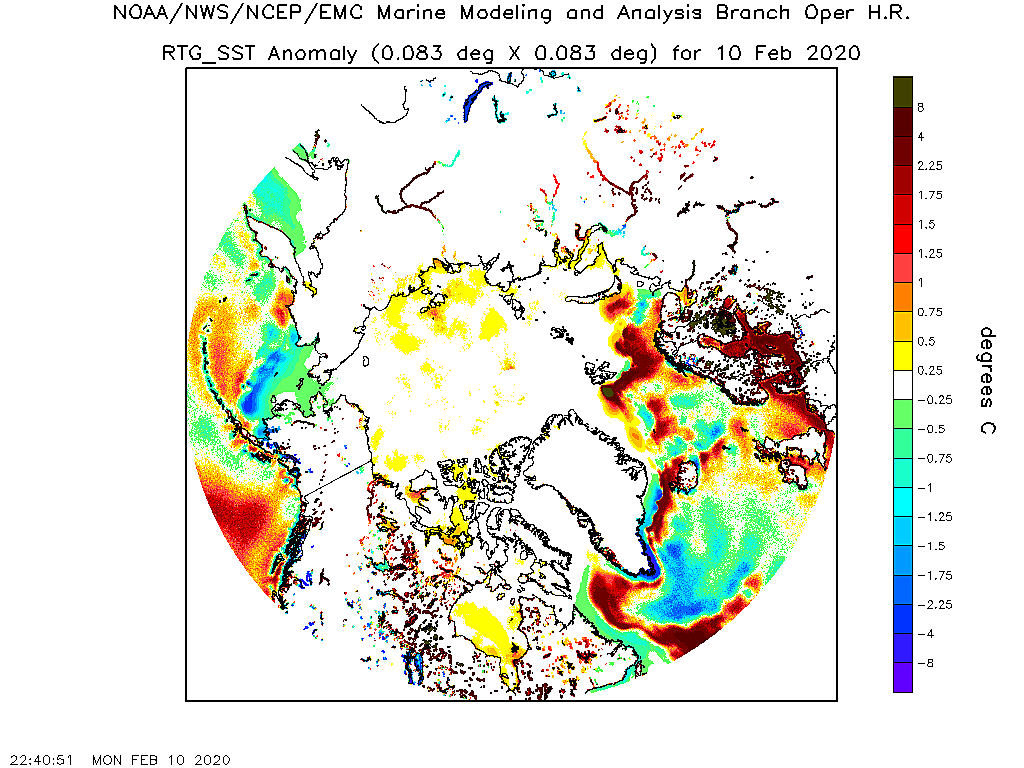
(I point out elsewhere that these maps can show water as red even when it is full of floating ice, as was the case in Hudson Bay last summer, which does make one suspect they are estimating on the warm side.)

In conclusion, we have a situation where we have a cold circle of ice atop the globe, surrounded by a larger circle of milder coastal waters, surrounded by an even larger circle of cold tundra. Until the coastal water freezes, the situation is wonderfully unstable.

The current temperature graph for areas north of 80° shows the current surge of mild air past its peak, and about to begin what I suspect will be a steep plunge.DMI2 1003B meanT_2015

The ice “extent” graph shows the mild surge did slow the refreeze, but couldn’t halt it.DMI2 1003B icecover_current_new

Most of our surviving buoys did show the milder air reaching across the Pole to Beaufort and Chukchi Seas, and the pacific side of the Central Arctic Basin, as the Atlantic and Siberian side haven’t experience the early season cold as much, and continue fairly mild. Yet the temperatures only briefly could thaw, in only a few places, and rather than thawing there was falling snow and freezing rain. Most of the slow-down in the refreeze was due to bottom-melt having a chance to occur without much upper-freezing,  and also gale force winds smashing up the new baby-ice.

It is unfortunate that O-buoy 10 got crushed (or perhaps retrieved by an icebreaker) as we have no eye down in the Beaufort Sea “Slot”. The NRL concentration map suggests the southern “reef” of the “lagoon” got dispersed by the gales, though we cannot tell if the water still has ice and slush in it once everything gets wet, as it doesn’t show up well to satellite sensors.  If the reef reappears during the refreeze we will know it wasn’t fully dispersed.Concentration  20151003 arcticicennowcast

I’ll download some pictures from cameras, and catch up on Faboo’s doings, in the morning.

ARCTIC SEA ICE —Klyuchi and the Quietude—(June 15-21, 2015)

In my zest for finding sensationalist headlines during a very quiet time of year up at the North Pole, even I have to confess it is darned quiet up there. It usually is. In fact my original reason for studying the views from the North Pole Camera, (back when it was THE camera), was because it was so serene, and my life isn’t.

Last year was a bit more exciting than usual, as the winter’s storms had done a good job of smashing up the ice, so we could dub it “The Pulverized Pole,” yet even by June 21 there was little sign of thaw. (The freezing-over lead to the right kept slamming shut, building a jumble of ice which in July buried our poor camera, and ended our ice-watching early)

np2-june-21c-18

Even the year before, (which brought this dog his day because I happened to be a reporter-on-the-scene when the media made a lot of hoop-la about “Lake North Pole” forming), there was no sign of thaw on June 29. (Open lead on far left horizon; pressure ridge on far right horizon) (Click all illustrations in this post to clarify and enlarge) (Original post about “Lake North Pole” was here: https://sunriseswansong.wordpress.com/2013/07/24/north-pole-ice-melt-watching-the-summer-thaw/ )

np-june-29-npeo_cam2_20130629141045 This year is no different, only perhaps a little more boring serene than usual, as we have no pressure ridges or leads to study in the distance.

NP3 1 0615 2015cam1_1 Therefore, to keep readers interested, I must look into the future seen by computer models to find storms which may merely be figments of computerized imagination, but qualify as hoopla until they vanish. I especially like low pressure systems that defy the textbooks, which state air should be descending at the Pole, and high pressure should sit on the Pole, at the center of the Polar Cell. polar-cell-atmospherecirculation When a low with its rising air sits on the Pole it grinds the gears, by turning the Polar Cell backwards, unless you do what I do, which is to insert a fourth counter-clockwise cell into the above illustration, at the very left, which I decided to give the grandiose name, “Superpolar Cell”. (I was thinking of calling it the “Caleb Cell”, but that seemed grander than grandiose.)

We had one of those interesting little storms last week, but things have gone back to their more normal, flabby, summertime state, where winds die down and ice doesn’t move much and nothing much happens except things slowly get more slushy. It is all very serene, but doesn’t generate many hits on this site, because it is boring because serenity doesn’t sell.

Therefore I was glad to see the GFS model showing a weak storm east of the Ural Mountains, over the small city of Klyuchi, which was forecast to wander up to the arctic coast and meander east for a week before penetrating in to the Pole.  This seemed news-worthy, but it had vanished from the GFS model this morning. In a sort of desperation I checked the other models, and Lo! The European saw Klyuchi heading north from Siberia on Saturday: (Greenland upper right)KLyuchi 1 ecmwf_mslp_arctic_21 The Canadian model was even better, having Klyuchi swing up from Bering Strait and cross the Pole heading for Fram Strait by next Tuesday: (Greenland lower left)

Klyuchi cmc_mslp_uv10m_arctic_31 Of course, the Canadian Model always is more imaginative, when it comes to storms, I think because it somehow always creates colder air. For example compare today’s 6z GFS map (Lower left, with Greenland to upper right) with today’s 6z Canadian (Lower right, with Greenalnd to lower left).

DMI2 0616 gfs_t2m_arctic_1DMI2 0616 cmc_t2m_arctic_2

The Canadian has stripes of pinker, colder temperature over the Pole where the GFS is blandly blank, so of course the Canadian will likely imagine us up some better storms. And if nothing else, this difference in the models, only 6 hours into the future, will give us something to make a hubbub about, even if Klyuchi never becomes a “superpolar cell.”

Not that there is anything wrong with quietude, but on the other hand sometimes it is fun to give them something to talk about.

TUESDAY EVENING REPORT —News from the Pacific and Polly’s ghost—

The map shows the situation is fairly sluggish over the Pole, which is as it should be, it being June. Klyuchi is entering stage right, just appearing on the coast of the Kara Sea. It is the big frog in the pond at the moment, though a weakling by winter standards, with it’s lowest pressure inland and barely below 990 mb. However he is the fellow to watch.

Also of interest is the ghost of Polly the Polar Storm, which is that weak 1003 mb low north of the New Siberian Islands and the Laptev Sea. She is suppose to have croaked, but like most ghosts she refuses to lie flat in her grave, and is managing to import enough of a feed of Siberian energy to expand isobars that have deflected the inflow of Pacific air away from any sort of cross-polar-flow, and instead to reroute it along the coast of Alaska.

DMI2 0616B mslp_latest.big

Therefore, if you thirst for thaw, you should go to Buoy 2015A: , which is right on the Alaskan coast and reporting a balmy +3.89° C.  With all the tundra-dust on the ice, and on the bottoms of melt-water pools, it is a case where most of the melting is occurring from the top down, rather than the more normal bottom-up melting we see in other areas. The Mass Balance Buoy, situated right in a pool, is reporting the bottom of the pool is sinking quite swiftly, and therefore is reporting ice thinner than the ice at the edges of the pool.

Buoy 2015A 0616 camera1 Northeast of there Buoy 2015B: continues a precarious existence, at the edge of a floe. One day it shows a vast area of open water, and the next the ice crushes together. We have separated from the Mass Balance Buoy, which has wandered off Lord knows where, floating in the water between bergs. (I’m not sure whether the GPS is attached to that buoy or our camera.) Temperatures are colder, but still thawing in the inflow of Pacific air, at +0.98° C.

Buoy 2015B 0616 camera2

It might seem that in a jumble of shifting ice like this it would be easy to determine if the ice was thinner, but it is more complicated than it would appear. For one thing, before it took a dive into the brine on June 9, the Mass Balance Buoy was reporting that, while this chunk of ice was starting to melt from the bottom, it was actually still 11 cm thicker than it was when the buoy was put in place back on March 26.  But you can see the open water, and also some thinner ice in the near distance made atop a lead’s open water back when it was very cold. We need some sort of average, but the average must also include the ice-atop-ice in the lower right, which is a bit of what is left of a pressure ridge that was heaped up when the ice slammed together.

So at this point one might turn to a satellite’s thickness-map, which might seem to do the job of averaging for us, however we are then presented with another problem. The blasted camera will not stay in the same place, but instead insists upon drifting. In this case it has gone crunching north.

Buoy 2015B 0616 _track

Just to show you how mentally tough it is to grasp “thickness”, I’ve drawn little circles around the approximate location of the above camera on a thickness map from March  29 and June 16. (Open to new tabs so you can click back and forth and compare.)

Ice thickness March 29 Painted arcticictnowcastIce Thickness June 16 Painted arcticictnowcast

What these maps seem to demonstrate is that, even with much of the ice melting in Bering Strait and along the Canadian coast, our camera has been crunched into a mass of ice which is, on average, thicker, (as is a lot of the ice in the East Siberian Sea).

These jumbles of ice are a real pain, when it comes to figuring out the extent of the ice, as while they are jumbled they cover a small area, but when the wind shifts they can be spread out like a pat of butter over bread, and cover a larger area with thinner and more widely spread ice, causing up-ticks in extent, even when temperatures are above freezing. (In fact I think this has just happened in Hudson Bay: All the ice was jammed down to the southeast by winds that were Northwest all winter long, but recently shifting winds have spread some of the ice back to the Northwest,  making the extent of ice on the bay show an uptick.)

In any case, the extent graph is liable to have a reluctance to shrink as fast this year, because the ice towards the Pole is more jammed-up and thicker.

DMI2 0616B icecover_current_new

However I think the NWS/NECP/CPC model is overboard, when it predicts above-average extent by August. (It predicted this last year, and it never happened.) (Click to clarify and click again to enlarge.)

Sea Ice anomaly forecast June 16 sieMon

North of 2015B the camera at O-buoy 12 has a lovely view of the Pacific thaw, with air temperatures at +0.91° C.

Obuoy 12 0616 webcamBack a bit to the east Obuoy 10 has failed to transmit since June 12, but was starting to show signs of melt-water pools forming in the Pacific air.

Obuoy 10 0612 webcam

It’s thermometer still works, and hints the thaw may be ending, with co-located Buoy 2013F: reporting -0.30° C.

Obuoy 10 0616 temperature-1week

However what really interests me is that the new pool is not forming in the same place as it did last year. Here’s how it looked last August 1:webcam What this suggests to me is that what was a weakness last year, a dent full of water, is now a frozen-solid strength and high-place on the ice. (I sure hope they can get that camera working again, so we can watch the thaw proceed there.) However the other thing to notice is that the ice looks far more solid, further north and east.

Anyway, that’s the news from the ghost of Polly, and the Pacific side.

QUICK WEDNESDAY MORNING UPDATE

First, another picture from Buoy 2015B over towards Bering Strait. Officially this picture is included to demonstrate how the ice piles up, but the secret reason is because it is just plain beautiful. (Open it to a new tab and compare it with the picture above to see how the ice piled up, remembering this same camera pictured a wide lead of open water only a few days ago.)

Buoy 2015B 0617 camera2 Second, a quick glance at the DMI pressure map shows the ghost of Polly showing remarkable persistence, as “Klyuchi” coasts eastward along the shores of the Kara Sea. Polly will likely supply the weakness that allows Klyuchi to cut left out towards the Pole.

DMI2 0617 mslp_latest.big

Lastly, our faithful North Pole Camera continues to watch dull, drab, gray skies,  with most of the below freezing air over on the Atlantic side of the Pole. The buoy actually did something rare yesterday, which was to stand still for six hours. After reaching its most southerly position of the summer, 87.105°N at 1500z on June 14, it dawdled back north to 87.115°N at noon on the 15th, but this morning has set a new record drifting back down to  87.09° N. This continues to be roughly 2 degrees north of where we were at this time last year.  “Polly” pushed it as far east as 3.296°W on June 12, but it has drifted back west to  5.032°W at noon on the 15th, hesitated back east to 5.008°W at 2100z, but this morning has it creeping west again to 5.12° W. We’ve rebounded from a freeze back to a thaw, at +0.41° C, yet it is down to  -0.79° C down south of there at Buoy 2015E: , which has just crossed 80° latitude and is heading through Fram Strait at 79.86° N, 0.13° E, likely to its doom.

THURSDAY MORNING REPORT  —More Quietude—

There was a reason the invasion of Europe was planned in June, back in 1944. It is suppose to be calm. God blessed the attackers in 1944 with a gale, which caused the Germans to lower their guard. A more normal situation would be like today’s, where the closest thing to a North Atlantic gale is a weak low over Iceland with a pressure of 1002 mb.

Klyuchi continues east along the arctic coast, and now is moving along the coast of the Laptev Sea. For the most part it only has breezes, but it has a small area of south winds up to 30 mph ahead of it, bringing some warm air from the sun-baked Tundra up to the ice pack. It is the strongest storm on the polar boundary between the Ferrel and Polar cells, with its pressure down to 984 mb.  DMI2 0618 mslp_latest.big The lobe of low pressure behind Klyuchi is the faded memory of Karabar, and it is interesting to note that once again the fading of a polar storm holds the coldest air over the arctic.DMI2 0618 temp_latest.big The lobe of low pressure north of Klyuchi is the faded memory of Polly the Polar Storm, and we are now reaching the moment of truth, where we will see if Klyuchi veers to the north into the weakness made by the remnant of Polly, and attempts to stand on the Pole as a “superpolar cell” as Polly did.

Conditions over towards Fram Strait remain quite calm, and the movement of ice has slowed greatly.

DMI2 0618 arcticicespddrfnowcast

Our North Pole Camera is nearly where it stood yesterday, at 87.08° N, 5.08° W.

Temperatures did dip below freezing, down to -0.6°C at 2100z on the 15th, but got back above freezing at noon yesterday, and are currently at +0.92° C.

As melt-water pools start to form, especially on the Pacific side where it has been warmer, there may be a sharp drop in extent graphs, as the satellite apparently can have trouble differentiating between a pool on top of ice and open water.

Our North Pole camera has looked out over a gray scene, with little warming sunshine, but Gray has a beauty all its own.

NP3 1 0617A 2015cam1_4 NP3 1 0617B 2015cam1_3 NP3 1 0617C 2015cam1_2 NP3 1 0618A 2015cam1_1

Thursday Evening Comments  —Textbook out the window—

I managed to find some time to just wander the web this afternoon. There’s a lot of interesting information about sea ice in the comments after a brief post by “Steve Goddard” at Real Climate Real Science, here:   https://stevengoddard.wordpress.com/2015/06/18/summer-2015-shaping-up-to-be-a-complete-disaster-for-alarmists/#comment-526620

This evening’s map shows Klyuchi starting to take the turn towards the Pole, which makes a mess of our neat textbook idea of a nice neat boundary between the Polar Cell and the Ferrel Cell at 60 degrees latitude.

I was trying to get my mind around an imagination that the center of the Polar Cell had shifted towards Iceland, and storms were orbiting the planet as if the planet was wearing a beret at a stylish slant. However it didn’t quite work, because a storm is about to cross the Bering Sea from  Siberia to Alaska. That storm is on the boundary between the Polar Cell and the Ferrel Cell, and you can’t have a second boundary to the north, unless…

A Spiral. Maybe the storm track could spiral in to the Pole, starting south of Bering Strait, crossing Alaska, Canada, Greenland, all the time trending more and more north, until it gets north of Siberia and swings up to the Pole, at which point it is north of the same storm track south of Bering Strait. A Spiral.

If course, that doesn’t fit the textbook either. And what happens at the center of the spiral? Wouldn’t it create a situation that is impossible, using the simplified scheme of atmospheric cells I illustrated at the start of this post?  And, even if it did not create what I dubbed a “Superpolar Cell”, what the heck would you call that central point?

Obviously this is too deep for a rustic like myself to figure out on a weekday evening, when my muscles are all aching from work. Therefore, rather than pretending I am a brilliant scientist, I think I’ll slump back to the more comfortable role of being a witness, and just observing the quirks of the quietude. (Hmm. That may be a good title for my next post; “Quirks of the Quietude”.)

I saved some nice pictures, as I zoomed past my computer today, only briefly pausing to snatch glimpses of what the cameras were showing. The first is from the most southerly camera, Buoy 2015A: , which is down at 70° latitude on the coast of Alaska, and which has experienced Pacific air and some serious thawing, with temperatures up close to +4° Celsius.

Buoy 2015A 0618 camera1

This shows you that, even with a midnight sun, the sun does get low enough at 70° to stop baking the tundra and melting the dirty ice. Also the water is not absorbing the sunlight. When the sun gets this low and the water is glassy, water actually has a higher albedo than grimy snow. You can almost feel the reflected heat from the water in your face, (if you have ever fished at dawn, or sunset, and have first-hand experience of such situations).

Still, you would not much want to go tramping across such ice. It qualifies as “rotton ice”, and the high places likely would be deep slush, and I would not trust the bottoms of the melt-water pools at all. When the sun gets high at noon the dirty bottoms of such pools do absorb sunlight (that is reflected when the sun is as low as pictured above) and eventually the melt-water bottoms may break through the ice, and abruptly become “bottomless.” The Mass Balance Buoy in this picture is measuring the sinking bottom of the pool it is in.

Buoy 2015A 0618 2015A_thick.thumb Winds,  which were from the snowless Tundra to the south, are swinging around to a sea breeze, and temperatures dipped slightly to +1.76° C when the sun got low. As the sun got high they rose to +2.69 C, which is still a degree cooler than it has been. But the thaw proceeds, close to land.

Well northeast of there, past 76°,Buoy 2015B: experienced its warmest temperatures of the summer,   +0.94° C even when the sun was low, but then temperatures didn’t rise swiftly  as the sun did, though they did rise and now stand at +1.04° C.

Buoy 2015B 0618 camera2

Due north of there, at 77°, Buoy 2014G: has seen temperatures drop with the rising sun, from +0.79° C to +0.39 C. It is co-located with O-buoy 12, which gave us this view, showing the melt-water pool to the left has nearly regained the size it was before it froze over and was covered with snow back around June 8.

Obuoy 12 0618 webcam

Seemingly we are lucky to be situated on top of a pressure ridge and not in a pool, which might cause the camera to slouch and examine its toes. (I saw O-buoy 7 do this for a solid month, two summers ago.) We are also lucky the pressure ridge didn’t topple our camera.

From there we can travel east to three buoys in the Beaufort Sea, all reporting temperatures just above freezing. O-buoy 11 pictures this:Obuoy 11 0618 webcam

It looks like the yellow trashcan they put up there (for polar bears to deposit seal bones in) is starting to tip. They just had a dusting of snow. What this picture cannot convey is how active the ice is just beyond the pressure ridge in the the mid-distance. Big bergs have surged back and forth, and occasionally the lead has widened into an expanse of open water. In order to gain an idea of this action you need to take a couple minutes to watch the end of the movie made of these individual camera shots, available at: http://obuoy.datatransport.org/monitor#buoy11/movie  The entire movie takes seven minutes to watch, but if you slide the bar at the bottom of the screen to the right and watch the final three minutes you’ll see what I mean. Also notice how the melt-water pool to the lower left keeps refreezing.

Then there are sadly no cameras for a long stretch, until we arrive north of Greenland at faithful, old O-buoy 9, (which at one point was closer to the North Pole than the North Pole Camera was, but now looks doomed to enter Fram Srait and face its eventual demise.)

Obuoy 9 0618 webcam

Over here on the Atlantic side the temperatures have grown colder.

Obuoy 9 0618 temperature-1week However, as the Atlantic is a new subject, and as my muscles are sore, I think I’ll leave discussing it until tomorrow.

Quick Friday morning update

Look how temperatures have risen at O-buoy 9 overnight.

Obuoy 9 0619 temperature-1week The snow looks like it is softening in the picture.Obuoy 9 0619 webcam This could be the start of a trend, as ot looks like weather will be fair for as long as ten days, as high pressure parks to the east of Fram Strait.  This may make the surface of the ice slushy, but very light winds, often from the south, will slow the export of ice south through Fram Strait.DMI2 0619 mslp_latest.big

As the Atlantic side warms, we’ll watch to see if “Klyuchi” chills the Pacific side at all, as it weakens and drifts across to the Canadian Archipelago by Monday.

The North Pole Camera is reporting a very slight and slow drift to the southeast, to  87.05° N, 4.62° W this morning, with temperatures gradually falling from +1.2°C at 0900z on the 17th to +0.14° C this morning.

The summer thaw is setting in and all buoys are reporting above freezing temperatures, with one strange exception. Way down in Fram Strait Buoy Buoy 2015E: is reporting -3.30° C.  Go figure.

There was a pretty picture from the North Pole Camera this morning, before it all went drab and gray again.

NP3 1 0619 2015cam1_2NP3 1 0619B 2015cam1_1 FRIDAY NIGHT UPDATE

Klyuchi has turned north and is heading towards the Pole north of the New Siberian Islands.

DMI2 0619B mslp_latest.big (1)

Klyuchi is at peak strength, and as it weakens I’ll be watching for cooling like a hawk. However I’m not sure Klyuchi qualifies as a true “superpolar cell.”  Rather the situation looks a bit like there are two polar cells, one centered over the North Atlantic and one over East Siberia, and Klyuchi is riding a stream between the two highs. Stoll, it throws the textbook idea of a polar high out the window.

The temperature map still shows warmth in the Bering Strait, even though it is midnight in the map below, and cold in Fram Strait, even though it is noon there.

DMI2 0619B temp_latest.big

The map also shows some below freezing temperatures around the edge of Klyuchi. On the coast of Alaska, Buoy 2015A: even dipped below freezing for the first time in days:

Bouy 2015A 0619 2015A_temp It has since recovered, but only to +0.72° C in the heat of the afternoon.

The warmest temperature I can find is northeast of there, in the inflow of warm air fueling Klyuchi, where Buoy 2015B: is reportiung +1.58° C. The snow looks like it is getting a little soft and slushy in the picture. It is rather neat how seamlessly a floe of ice has nestled against our floe, to the left, but the open water to the right makes me a little nervous. I am under no illusions about the life-expectancy of this camera, if that lead decides to slam shut, and the high clouds of Klyuchi are approaching from the upper left.

Buoy 2015B 0619 camera2 Across the Pile from here our faithful North Pole Camera has seen it’s recent thaw give way to below freezing temperatures. As recently as 0600 on the 18th it was at +1.1°C, but the slight rise of the sun that far north brought no heat, as by 1500z it had dropped to -0.6°C. The current reading (date stamped tomorrow, June 20, as they are near the meridian), is  -0.51° C.

It is not surface melting that wipes out that ice, but rather getting flushed south into the North Atlantic, and we are not making much progress in that direction. We moved from 87.094°N, 5.114°W at midnight on the 17th (which was as far west as we got) to 87.049°N, 4.649°W at 2100z on the 18th, which is 3.51 miles in 45 hours. That is about the speed a turtle walks. (The latest report puts us at 87.04° N, 4.50° W, (on the 20th, without a time stamp) which is only eight tenths of a mile further southeast.) We are not likely to be flushed south until some sort of decent gale gets going, and that seems unlikely in the next week.

SUNDAY MORNING SUMMERY  —Klyuchi Crossing—

DMI2 0620 mslp_latest.big DMI2 0621 mslp_latest.big

As Klyuchi drifted across from Siberia towards Alaska and weakened, things remained very quiet in the Atlantic side. The North Pole Camera drifted southeast all of 0.57 miles, moving from 87.049°N, 4.649°W at 2100z  on the 19th, to 87.044°N, 4.506°W on the 20th, and then proceded to get reluctant, and backed up to 87.047°N, 4.511°W at 2100z, which reduced our progress towards Fram Strait to 0.49 miles. At this rate we’d get to the Strait in around a year, but I don’t suppose we’ll stay at this turtle’s pace.

Interestingly, temperatures rose from -0.5°C to + 0.9°C as we headed southeast, but sank back to -0.8°C as we headed back northwest. (I would have thought the more northerly winds would have been colder, but we are talking about very light airs, and likely small pockets of colder and warmer air.

The North Pole Camera’s thaw was accompanied by a bit of blue sky and sunshine

NP3 1 0620 2015cam1_4

Then things grew gray and foggy as it chilled, and this morning sees obscured sunshine, with temperatures down to -1.80° C.  The summer continues very gray up there.

NP3 1 0621 2015cam1_1

I’ll get to the Pacific side later. It was very warm on the coast of Alaska, as air was drawn north to Klyuchi from the land. Right on the coast 2015A was up over +7.0 Celsius.

SUNDAY AFTERNOON  

Klyuchi continues to fade away, with a very weak secondary swung around in its wake, and also a trailing storm that zipped up from Central Asia (“Trailor”) also following in its wake, but likely to be swung around further south and to pass over to North America closer to Bering Strait.

DMI2 0621B mslp_latest.big

“Trailor” may swing around along the coast of Alaska and then head out into the Beaufort Sea for a while, however it looks like the next real assailant of the Pole may come up through the Baltic Sea  towards the end of the week. In the meantime things look like they will stay fairly dull and calm, so I will conclude this post and begin a new one, which I think I’ll call “Quirks of the Quietude.”

Klyuchi hasn’t created any significantly colder air, though small pools of sub-freezing air continue to appear, despite the 24-hour-sunshine and the sun being as high as it can possibly be.

JUNE 20 0000ZDMI2 0620 temp_latest.big JUNE 21 0000ZDMI2 0621 temp_latest.big JUNE 21 1200ZDMI2 0621B temp_latest.big

Our North Pole Camera continues to dawdle up well north of Fram Strait, arriving at 87.036°N, 4.080°W at 2100z yesterday, which is only 1.71 miles to the southeast in 24 hours. Winds have picked up slightly to 11 mph, and the temperature appears to be currently nudging above freezing after bottoming out at -1.6°C at noon yesterday, and climbing back to -0.7°C at 2100z.

The real thaw is occurring on the coast of Alaska. Buoy 2015A: had temperatures above 7° C. and though it recently dropped back to +1.04 C it looks like the ice may be getting thin at the bottom of the melt-water pools, around 18 inches. The Mass Balance Buoy even seems to have a very slight tilt. If its hole supplies  a channel, the melt-water may drain down and the ice rise up a little, which would be interesting to see.

Buoy 2015A 0621 camera1 Beyond that possible excitement, it looks like we are stuck with peace and serenity for a while. And actually, that may not be an entirely bad thing.

ARCTIC SEA-ICE BUOYS —Observations June 1, 2015

Now the fun begins, as we enter the 40 days when the sun has the most power at the Pole. Now is the time the Alarmists have been waiting 320 days for, when the snow wilts even when temperatures are below freezing.

Even though summer lasts long beyond these 40 days, and the sea-ice extent decreases well into September, now is the time when the most dramatic sagging of snowbanks, and shrinking of pressure ridges, and growth of melt-water pools can be expected. Indeed, after these 40 days some freezing can start to appear at the surface, and this freezing can be expected to increase, even as melting continues from beneath, and ice breaks up well into September.  In terms of stuff you can see from above, and photo ops, these next 40 days are time to put up or shut up, for Alarmists, looking for doom and gloom and reasons to despair.

Yet they are also a time of hope, if you like the idea of a warmer world, and the Medieval Warm Period returning, and Greenland becoming green again, and its permafront thawing and growing barley as it did for the original Vikings. For a brief time one sees hints of the starkness fading, and a climate optimum returning, and the dry parts of the world standing astounded at the sighing of rains: The Sahara becoming grasslands dotted with lakes. The red mesas of the American Southwest covered with jungle green. Such optimism may only be the overly fond hope of a dreamer, but, as the sun beats down on the arctic from midsummer’s heights, it is dream briefly validated.

Given the choice between despair and hope, I’ll chose the latter, and rejoice at the victory of summer over the most wintry part of the world, even as my more cynical side suspects the victory will be brief. Why brief? Because the powers of despair are ascending. Why rejoice? Because such powers cannot win, and in the end the deserts will bloom, and the north-lands know mildness. Is this faith and not science? Yes, but so is belief in Global Warming.

Currently the power of the sun is most obvious at Obuoy 12. Despite a shot of very cold air, the diurnal rise of the sun nearly tugs temperatures above freezing down near latitude 76°:

Obuoy 12 0601 temperature-1week

And, despite the fact temperatures can’t nudge above freezing, and often are well below, the sun still has the power to soften snow, wilt the sharp points of pressure ridges, and even expand the beginnings of melt-water pools:

Obuoy 12 0601 webcam Obuoy 12 0601B webcam

But hide that glorious sunshine with clouds, and things become more pessimistic, even well to the south, south on the coast of Alaska. As the same shot of cold arrived, Buoy 2015A saw its promising melt-water pools freeze over and be dusted by snow.

Buoy 2015A 0531 camera1

Buoy 2015A 0601B camera1 This demonstrates the simple power of sunlight; beautiful golden sunlight. One observation I made last summer was how often it was gloomy, over the arctic cameras. If you want to see, (for whatever reasons, whether they be hope or despair), the ice melt, then hope for clear, blue skies.

I think that, for clear skies, a zonal pattern is better. We need the AMO and PDO to get in harmony, and to quit the business of provoking each other into kick-backs, for that seems to perturb the jet stream into extreme non-zonal, meridianal, meanderings, which brings moisture north and makes our Polar skies cloudy.

However it is interesting to watch the wild meanderings, and see cold air surge across the Beaufort Sea, if only because it effects the antics of the sea-ice. For example, the ice Obuoy 9 sits on was politely moving east over the top of Greenland, on its way to an organized exit from the arctic via Fram Strait, when this surge of cold air hit it, and the ice did an about face and began marching west back from longitude 18° towards longitude 20°,

Of course, when all this ice is moving east and then decides the heck with that, and to move west, it is like the traffic on the eastbound lane of an interstate all deciding to put on the brakes and accelerate west in reverse gear. Only the bergs are a heck of a lot bigger than cars and even tractor-trailer trucks. (Doing a back-of-the-envelope calculation, I estimate the total weight of the ice at 65 kazillion grams.) You can expect amazing pile-ups, and also leads to open, and to create areas of “highway” with no traffic at all.

This makes the images from Obuoy 9, if nothing else, dramatic (especially with the mountains of Greenland in the background, when the sea-smoke lifts.)

Obouy 9 20150521 webcam

Obuoy 9 0527 webcam

Obuoy 9 0601 webcam

Obuoy 9 0527 webcam

(One interesting thing about these pictures is the dark area of sky along the horizon to the right. Adventurers who have trekked up there state this often indicates a lead of open water, which is dark blue, and reflects its darkness onto the low clouds. Therefore we ought to suspect the reverse in the direction of the ice has torn a big lead open, just over the horizon and out of our view.)

When ice reverses direction it may open leads of open water in some places, but in other places it makes “crazy ice”, which can consist of jumbled pressure-ridges. And to be midst such a jumble is hard on buoys and cameras. Sadly, it seems our oldest and wisest buoy, Buoy 2012G:, may have suffered such a fate. It’s last clear report was on May 20, and its temperature graph seems to hint it may be reporting from under a jumble:

2012G_temp

Still, 2012G gave us one heck of a ride, while it lasted:

2012G_track

One-heck-of-a-ride is a decent pay-back, and a lot more than we get from other ways the billions our government pours into “Global Warming” pays us back. It seems to me a lot is totally wasted on computer models that don’t work. (I’m not talking about the long-term models weather forecasters use, but rather about the absurd models that supposedly predict “Climate Change”, but utterly and hopelessly fail.) Even more money is squandered “adjusting temperatures”, (which seems to me to be the falsifying of public records, and a crime). Then “public relations” gets a hugely disproportionate share of the tax monies, especially when you consider “public relations” has nothing to do with science, and everything to do with propaganda. Lastly, there are various junkets and conventions which have nothing to do with science, but seemingly have something to do with rewarding the bribed. All things considered, the buoys and cameras actually doing work and expanding our knowledge of the Arctic don’t even get a tithe of the money spent.

We do get one-heck-of-a-ride from the other money spent, because it isn’t spent on our infrastructure. The state of the State Roads in New Hampshire is worse than I’ve ever seen in my life, and I can tell you, from first hand experience, driving over them is one-heck-of-a-ride. But perhaps that is more of a subject for a “Local View” post, and not for an “Arctic Sea-Ice” post. However, before I return you to your regularly scheduled programming, I must mention this:

At some point the vast amounts spent on Global Warming will seem largely a waste, and there will be huge budget cuts. When that time comes, the bureaucrats will want to cut the funding for things like the North Pole Camera, and keep the funding for their own jobs. At the risk of sounding inhumane, and preferring inanimate cameras to living, breathing people with children to feed,  I say we should cut the bureaucrats long before we cut the cameras, for the cameras produce and the bureaucrats only leech.

Speaking of cameras, up towards the North Pole the North Pole Camera is well west and north of where it was at this time last year. It was doing its best to head down to Fram Stait, and crossed 88° latitude back on May 26, and got as far south as 87.947°N on May 29, but since then it has got caught up in the surge towards Beaufort Sea, and backed to 88.019°N at 0300z on May 31.  Not only that, but, because it must move east to get to Fram Strait, it seemed obedient, as it moved east to 11.055°W at midnight on May 29, however since then it has been very disobedient and headed west. At last report ( 2100Z  on May 31) the camera was at 88.014°N, 13.265°W and headed west in light winds.

The surge of cold air towards the Beaufort Sea has done one thing: It has brought abrupt warming to the Pole. At nine o’clock on the 30th the camera was at -8.4°C, but 24 hours later it stood at -0.5°C, and we were on the verge of our first thaw of the summer. (You will notice, from the picture, there is nothing but sunshine, and no gloom.)

NP3 1 0601 2015cam1_1

The beaming sunshine has allowed temperatures to shoot above normal for the first time in a long time, north of 80 degrees latitude.

DMI2 0601 meanT_2015

Do not be fooled by this graph. It is important to remember it does not include much of the Beaufort Sea, which is south of 80 degrees latitude, and where much of the cold air has been shunted:

DMI2 0601 temp_latest.big

What I’ll be looking for, in terms of melting the sea-ice, is lots of sunshine at the Pole. If it gets gloomy like last year, forget it.

NORTH POLE CAMERA UP AND RUNNING

NP1 0417 2015cam1_4

DANGER  Looking at these pictures can be addictive. Furthermore, they can lead to arguments about sea-ice with fanatics, and even (gasp) holding the politically incorrect view that there is no “Death Spiral” and the North Pole isn’t going to become ice-free.

On the other hand, looking at these pictures is soothing on hot summer days, a good way to forget pressing issues and to zone out, and can introduce you to interesting people.

The above view is from camera 1, and is a wide angle lens. I’m not sure what the deal is with camera 2 this year, as it seems to have a narrower view.

NP2 0417 2015cam2_2

The link to these pictures is  http://psc.apl.washington.edu/northpole/index.html .

Currently the camera is at 89.651°N,  38.819°W and is drifting northwest, which is a little unusual, as the camera tends to head south towards Fram Strait. Usually they continue to send pictures into September, but last summer one was knocked over (perhaps by a bear) in late June, and the second was too close to a pressure ridge, which buried it in rubble later in July.

The camera is undergoing a “heat wave”, as a southerly wind has raised temperatures from -15.5°C on at 1730z on April 14 to -2.7°C at 1800z on April 16. (4.1° to 27.1° Fahrenheit)  Winds are quite strong, at a steady 22 mph (gusts aren’t reported.)

Barneo wind April 16 317886_original

The cameras are deployed from the Barnea Camp. With these winds, it must be rough on the tourists at that camp. (See my post at:  https://sunriseswansong.wordpress.com/2015/04/13/jets-landing-gear-fails-at-pole/  )

The cameras take a group of three to six pictures, four times a day. One trick I have learned is to open the pictures to a new tab, and then click back and forth between the pictures. This makes slight shifts in the ice, which otherwise would be difficult to notice, jump out at you, but you need to be careful not to be tricked by the shifting shadows. (One thing to keep an eye out for is polar bear tracks. Keep your fingers crossed no bear gets interested in the camera, because those bums have no respect for all the hard work and tax-dollars involved.)

Usually nothing much happens for the first month or so, as things are basically frozen solid, and temperatures seldom get above freezing until June. Once temperatures get above freezing, they can stay above freezing for over a month, as the sun never sets, and the melt-water pools start to form. Of the camera moves south into Fram Strait the final pictures sometimes show a nearing ice breaker, sent to rescue the camera.

I am thinking I might start a “Polar Camera Post”, with views from these cameras, as well as the four “O-buoy” cameras, plus some of my amazingly witty and lucid comments.

An elongated low north of Greenland is causing the winds, and bringing the mild air north.

DMI2 0417 mslp_latest.big DMI2 0417 temp_latest.big