
One thing I’ve learned, as I have attempted to fact-check Alarmist’s sensationalist claims over the past decade, is that sea-ice exists in a sort of teetering balance between a single power that chills, and a multitude of powers that warm.
The single cooling power is the loss of heat to outer space, which continues at a quite regular rate 24 hours a day 365 days a year. Although clouds, and sea-ice itself, form insulation slowing the escape of heat at the surface and from waters beneath the ice, the hungry maw of outer space is constant in its demands. It is the loss of heat to outer space that creates the sea-ice.
Countering this chilling are warm forces constantly attempting to melt the sea-ice. These forces include many that operate even in the dead of winter, including warm air masses, warm currents, the temperature of the Arctic Sea itself, and rising warm plumes of water over undersea volcanoes. But the force that gathers the most attention is sunshine, which only operates six months a year.
The theory called the “Death Spiral” worries that, once the sea-ice is melted, the darker water will be able to absorb more sunlight than the white sea-ice, due to “albedo”, and this will cause the water to warm, and warm water will melt more sea-ice, and this will become a vicious cycle until there is no sea-ice at all, which will cause dramatic, disastrous warming over the rest of the planet.
This worry is needless for a number of reasons. Perhaps the most obvious is that the Arctic Sea has been ice-free in the past, perhaps as recently as the Medieval Warm Period, (and perhaps, on the Atlantic side, as recently as 1817), and there was no vicious cycle seen. If it didn’t happen then why should it happen now? Other reasons the worry is needless are less obvious, but have been fascinating to study.
The first is that when the sun first rises at the Pole the snow is at its most pristine and Albedo is at its highest. Also the ice is chilled to as much as forty below, at the surface, and even when the surface is warmed the chill lingers down deeper in the ice. The sea-ice is so cold salt can’t melt it, and a surprising amount of salt-dust is mixed in with the snow in places. Then, as the sea-ice is warmed from both above and below, the salt starts to melt the sea-ice, which actually is a process which uses up available heat. (Think of an old fashioned crank-operated ice-cream-maker.) All in all there is so much resisting the warming that it often isn’t until the days are already starting to grow shorter that slush starts to form on the surface, and melt-water pools appear

Because these pools are darker, at first they indeed have a lower albedo and absorb more sunlight, however as August proceeds they start to skim over with ice, because the sun is dipping towards the horizon, and, once the angle of the sun gets low, water (especially when it is glassy) reflects sunlight (think of the late-day glare which requires sunglasses). Water then has an albedo as high as sea-ice, especially dirty sea-ice. Therefore the sea-ice melt seen in September is largely caused by the warmer water under the sea-ice, and not the sunshine above. Lastly, because the open water largely appears when the sun has ceased to penetrate the water, the sunshine cannot be heating the water and cannot contribute to a “Death Spiral”.
A second fascinating thing to study is the drift of the sea-ice. It turns out the amount of sea-ice at the Pole can be decreased not by heat, but by simply exporting large amounts to warmer waters (which happened to such an sensational degree in the spring of 1817 that there was open water north of Svalbard and Greenland, yet icebergs grounding on the coast of Ireland.)
A third study is the wandering currents which feed warmer water into the arctic. These currents apparently vary in their temperature, depth and location, having something to do with a cycle of roughly sixty years called the AMO. (Atlantic Multidecadal Cycle). In the past fishermen have noted some dramatic shifts in the location of fishing grounds, and there are incidental reports in historical records of notable changes in water temperatures, and how much ice is along coastlines, and how far glaciers extend into the sea. While these historical reports are dismissed by some scientists as anecdotal and too scattered to be useful, scientists themselves only have scattered data back sixty years ago, when the AMO was last doing what it now (perhaps) is going to do again. But a “Cycle” is very different from a “Death Spiral”, and currently there is more evidence the arctic follows cycles than evidence it is headed down a one-way street to disaster.
A fourth effect has been studied even less than the AMO, and is the occurrence of under-sea volcanos. This has grabbed my attention now due to the appearance of a mysterious hole in the sea-ice, seen in the NRL maps starting roughly at the end of March, but only sizable and clear over the past thirty days. It is located roughly at 85 degrees north and 110 degrees east.
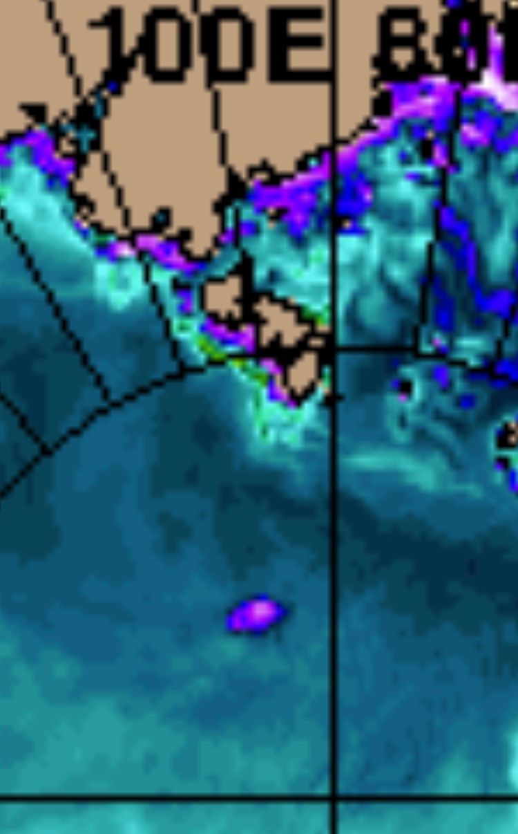
I have only seen this sort of event once before, roughly seven years ago, at roughly the same location. Back then a reader asked me what it was, and I had no answer. They suggested it might be caused by a plume of warm water rising from a volcano, but that particular event was so brief I could only shrug it off and say “perhaps”, but confess I had never read of such a thing. But this one has been longer lasting. It appeared to be associated with no above-freezing temperatures nor with a lead or pressure ridge in the sea-ice, and also to move in a very odd manner. For example, when the sea-ice drifted to the right it would drift more slowly and even seem to stand still, and when the sea-ice swung around and drifted the opposite way it would remain in the same place. Lastly it has persisted despite constantly sub-freezing temperatures, and even to be enlarging. To me this seems consistent with a plume of milder water rising and persistently melting the sea-ice from the bottom.
Now seems a good time for the Navy to plan some sort of long distance training flight, and also to drop some sort of buoy or sensor into that water. If I was a sea-ice scientist I’d be hectoring and wheedling for such an expenditure. I imagine such events (if it is truly such an event) are not that common.
It is also interesting to think about the effects of such an upwelling. Likely it would derange the system of currents at that location, at various depths beneath the sea-ice, and trouble the stratification of water with upwelling turbulence. This in turn would have an effect “downstream” in the temperature and even location of the currents involved, which in turn could effect other currents.
We have heard much talk about “tipping points”, and how bovine flatulence and curly lightbulbs are things the fate of our planet hinges upon. However here we may be seeing a far more meaningful event, which could have repercussions like dominoes, and lead to interesting changes. Likely it has happened before, but by studying what happens this time we may be able to to look backwards and say, “Ah ha! So that is why that happened!”
In any case, it gave me something to get excited about during a basically dull time at the Pole. There has been a “Ralph” sitting over the Pole, but it was weak and the air has basically stagnated up there, without any roaring gales. There has been a slow but steady flow of sea-ice south through Fram Strait, but the current sluggishness of systems has revealed something that isn’t always apparent: Despite 24-hour sunshine, the arctic is still losing heat to outer space, and still creating cold air. Otherwise the DMI temperatures-north-of-80-degrees-lattitude graph could never show a downturn like this:

This downturn demonstrates that the Pole’s temperature is an equation, basically a fixed amount of heat being lost, and a varying amount of heat being added. To be a bit overly simplistic, in the dead of winter 100 units are lost and 70 added, which gives you a temperature of 30 below. Now, with more sunshine and warmer landscapes to the south, 100 units are lost and 90 are added, which gives you a temperature of 10 below. It is a bit of a misnomer to state the arctic is warming, for in fact it is still losing. It just isn’t losing as much.
In fact sea ice is still forming at the Pole. The “extent” graph only starts its yearly crash because large areas of sea-ice in more southerly climes, such as the Sea of Okhotsk, melt away. This year we are a hair behind last year’s rate of decrease (not that it means much this early):

Despite the loss of all the ice to the south, the “volume” graph shows the loss is countered by an increase in sea-ice to the north, and the total volume never starts to drop until around about this time every May.

This graph demonstrates that, despite a possible volcano melting the underside of the sea-ice at one locale, we have more ice up there than last year.
I hope to post again soon, with some maps of the weather events up there, now that my taxes are done. (The dull period may be ending, as a bit of a Barents Sea Blaster may be brewing). But I figured I’d whip off this post to alert people to the possibility of an undersea volcano up there.
Stay tuned.

I would guess not a volcano and just an artifact of the currents and moving ice ….. but I am guessing.

Your feature is near the Lomonosov Ridge but it is a feature of continental crust versus the ocean ridge beside it – Gakkel Ridge which looks to be an extension of the Atlantic mid ocean ridge ie Iceland and so volcanoes on it would surprise me.
Actually checking again it looks like the feature is nearer to the Gakkel Ridge ….. getting near the pole really messes with orientation / location in my pinhead.
The “hole” is roughly halfway between the Pole and Severnaya Zemlya, which is fairly close to that Gakkel Ridge. I can always fudge a bit by saying currents keep the plume from rising straight up. But seek out the newer Naval Reserch Lab sea-ice maps. If you wind up on the old site there’s a link to the new site. Then animate the last thirty days. It is odd how the “hole” reforms and refuses to freeze over. Maybe they could cruise a sub nearby nd see if they notice anything.
I’m especially thankful for the handy sea-floor map. It adds a lot to this post! (And the arctic disorientates me too. At the pole every direction you turn is south!)
Did you notice the big eruption in Icelnd?
Pingback: ARCTIC SEA ICE –The 2023 Maximum and the Ilk of Al– | Sunrise's Swansong
Pingback: ARCTIC SEA-ICE –DEALING WITH PETULANCE– | Sunrise's Swansong