
“The Last Rose Of Summer”
‘Tis the last rose of summer left blooming alone
All her lovely companions are faded and gone
No flower of her kindred, no rosebud is nigh
To reflect back her blushes and give sigh for sigh
I’ll not leave thee, thou lone one, to pine on the stem
Since the lovely are sleeping, go sleep thou with them
Thus kindly I scatter thy leaves o’er the bed
Where thy mates of the garden lie scentless and dead
So soon may I follow when friendships decay
And from love’s shining circle the gems drop away
When true hearts lie withered and fond ones are flown
Oh who would inhabit this bleak world alone?
This bleak world alone
Thomas Moore
I was considering abandoning these Sea-ice posts today, as it seemed foolish to waste the power of my pen on such topics, when it seems my purple prose might be of more use in opposing a gas pipeline through my backyard. Call me NIMBY if you will, but the pipeline would not be necessary if people in Europe were not idiots about Global Warming, closing down perfectly good coal plants for dysfunctional wind turbines, and solar panels where the sun hardly shines in December. And, because the elite snobs of my neighboring state want to copy Europe, even to a degree where they fake make-believe English accents, they too are closing down coal power plants and need natural gas. However here in New Hampshire we actually export power, thanks to the Seabrook nuclear power plant, and also the fact we have some power plants that burn our trees. So we do not need a pipeline. Europe and Massachusetts do. So let the pipeline go through Massachusetts backyards.
I can wield a very nasty poisoned pen when I want, sharper than any sword. Despite the fact I recognize the fact fossil fuels have lifted mankind from mean poverty, and the fact some of my best friends work in the coal, oil and gas industry, I can rabble rouse, when it comes to outsiders ruining my homeland for their outside interests.
And I know I must be deemed rabble, to be treated in the manner I and my fellow citizens are being treated by our insane president and the insane politicians in Washington DC. We are not worth the time of day. We are like Cherokee before the Trail Of Tears, Like Navajo before the Long Walk, like Scots before the Clearances.
Therefore I am not going to waste my time discussing the silly politics involved in Sea-ice. The “Death Spiral” has been so completely debunked that anyone who still believes it might be real is embarrassingly deluded. They, and not I, are a “denier”. For heaven’s sake! Today’s extent graph shows we are nearly to the line deemed “normal” ice extent. The idea of an ice-free Pole is complete humbug in the face of such evidence:
I rest my case.
It is amazing to me that, despite this and other evidence, the president of the United States persists in erroneous statements. I cannot believe he is misinformed, and misguided. I believe he is well informed and is fully aware he is misinforming the American people. He simply is hard-bitten and cynical and has the horrible belief that Truth does not matter. In conclusion, (and I have a hard time saying this about any fellow American, but say it as a warning to the rest of the world,) he is evil.
Truth is goodness. Falsehood is evil. Knowledge is good. Ignorance is evil. Truth is beauty. Lies are always ugly. If you believe there is such a thing as a “white lie”, you are probably a racist.
Suppose I had to hide a fugitive from a Gestapo. Would I lie to the Gestapo, when they burst in? No, for I would have moved my chair, and would honestly tell them, “I’ve been working in this room all morning, and as long as I’ve been sitting here no fugitive has come into this room.
People who live in the Truth would immediately recognize that statement as crafty, and might cross-examine me, but people who live a lie have lost that ability. You don’t need to lie to misguide them, for they are so misguided to begin with they basically have no idea where they are. I pity such blindness, but such people can be a problem, especially when they grasp power and become a president.
I think the time has come for people who can see to speak to the blind. I am going to do my best to do so, though at times it is like trying to convince the tone-deaf there is tone or the color-blind there is color. It is a weary task, and at times I just want to get away from it all, and rather than needing to teach power-mad, greed-mad, and lust-mad morons, I want to just sit back and be the moron, being taught by the Truth.
Henceforth, that is all these Sea-ice posts will be. For Sea-ice doesn’t care about the president, or the United Nations, or Isis. It is simply the Truth. And, like a child looking at summertime’s clouds, we are disciples watching our guru. We are humble students, and the arctic is our teacher. It is the poetry, the symphony, and we are the audience, listening in awe and feeling our souls expanded as we heed.
We are now entering the final time of the summer thaw. At first we will see the surface freeze, and then the sides of burgs and surface of the exposed salt-water, and lastly even the bottoms of the bergs will stop melting and start growing.
I am going to attempt to ignore the annoying politics involved. Skeptics tend to root for ice not melting, and Alarmists root for ice melting, and both sides go through anguish as we approach a point where ice will either have melted more or less than last year.
In Truth, it really doesn’t matter a hill of beans. It is a tiny variation, in a huge scheme of things. It is like worrying about how many micro-millimeters your child’s fingernail grows, and keeping charts, and worrying about that “science” so much you forget to tuck the child in and kiss it good night.
In the end, we shall see what we shall see, and the arctic shall do what the arctic will do. It will be above our heads, but teach us much, if we simply observe.
The North Pole Camera, that I call “Faboo”, has been interesting this year as it has not been slushed down towards Fram Strait, and in fact is further north than I can recall a North Pole Camera ever being, in August. Two years ago the camera had a hard time getting south of 84° latitude, but this year we’ve had trouble getting south of 86°. Last Friday we headed 1.37 miles north to 86.287°, which puts us back where we were in mid July. On Saturday we continued north as far as 86.296°N before we finally resumed expected behavior, and made it south to 86.290°N, 7.959°W, which means we moved 0.31 miles in twenty-four hours. At that rate we would make down to Fram Strait in 2016, likely in December. This is very different from “normal”. and we, as students, should be attentive to what the guru is teaching us.
As very little happened, in terms of movement, a big swing in winds from south to north occurred, and temperatures swung from thawing on Friday to freezing on Saturday. Friday saw a low of +0.5°C at midnight and a high of +1.2°C, which seems nice and diurnal and normal, but Saturday was not diurnal, with the high +0.9°C at midnight crashing to a low of -0.9°C at noon and then to a lower low of -1.6°C at 2100Z. What was the guru teaching us?
The pictures from this time teach a lot to poets who dream at clouds. First we see the thaw.
 But then clearing brings sharply colder temperatures.


I’ll continue these observations tomorrow, including the O-buoy visuals.
MONDAY MORNING UPDATE.
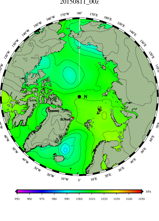
Very little action occurring over the Pole. Perhaps this will allow inversion to increase the cold? The cold still is centered on the Pacific side, and rings the Pole.


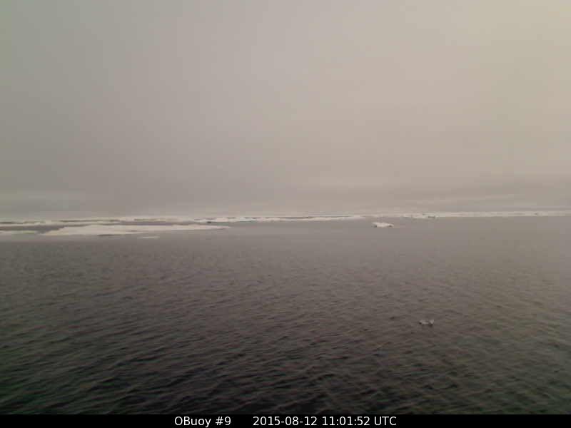
O-buoy 9 continues to drift the “wrong way”, to the northeast, through calm and fog and temperatures right at freezing. The dirt on yesterday’s berg may be from any number of sources, including wind-blown tundra dust, volcanoes, Chinese power plants, underwater algae, and glacial moraines. 
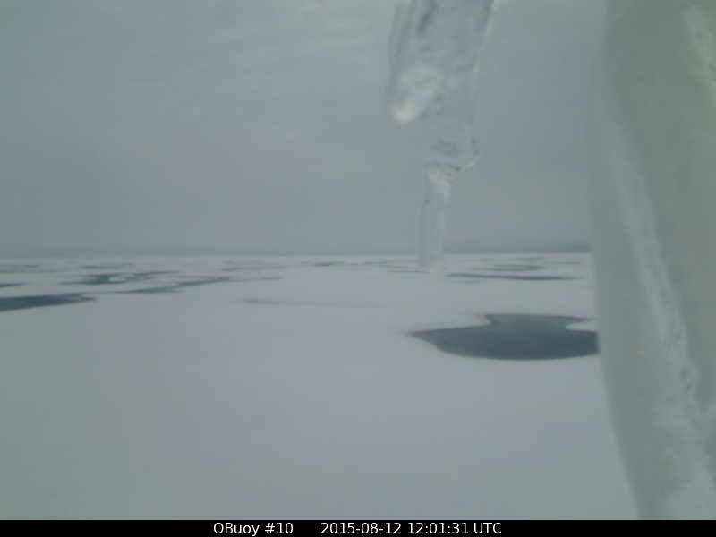
 O-buoy 10 has started drifting back north, with temperatures nearly up to freezing in the southerly wind, and milder air aloft producing drizzle that is falling and freezing onto the dangling strap in front of the lens. The melt-water pools remain frozen over, and there is no sign of the ice cracking up yet.
 At O-buoy 11 to the southeast, where the ice has cracked up, the ice is also moving north and temperatures have risen, but not above freezing. It is unusual to see a skim of ice on sea-water this early. I wonder if the Satellite sees such a very-thin layer of ice as open water or as ice-covered. That second picture is just plain beautiful, and worth enlarging and forgetting science with, for a bit.
 Over to the west O-buoy 12 has started south again in light winds, and continues to experience sub-freezing conditions. The ice looked jammed up and cold yesterday, but now will start spreading out and dispersing.

 MONDAY EVENING UPDATE
Faboo returned to some degree of normalcy yesterday, drifting 2.07 miles due south to 86.260°N, 7.955°W. Winds were light, and some of the coldest air we’ve seen since June wafted by with temperatures falling to -2.4°C at 0300Z. Temperatures remained cold, only rising to -1.0°C at noon, and then spiked up to the threshold of a thaw at 1500Z with a reading of -0.1°C, before sliding back a little to -0.6°C at the final reading at 2100Z. Today it looks a little warmer, with mackerel skies.

 To the south O-buoy 9 has had a run in-with what appears to me to be not sea-ice, but a berg calved off a glacier. The bigger bergs of sea-ice are made up a jumble of slabs cemented together, but this berg looks like pure, packed snow. You can get a faint glimpse of the larger part under water. Winds are nearly calm and temperatures a hair below freezing. We are nearly east to 5° longitude.
 Over in the Beaufort Sea we are flirting with thawing, in light 9 mph winds. I’m hoping we can melt that ice from the strap obstructing our view. The wind shift to south has swung us around in our private melt-water pool, so we can look back at the neighboring buoys.
 Southeast of there O-buoy 11 is also attempting to thaw, with 9 mph winds and temperatures right at freezing. The small iceberg in the center looks like it left a path through the very thin new ice.
 Over to the west O-buoy 12 is seeing winds starting to slack off after blowing around 10 mph a while. Temperatures continue a hair below freezing. Ehat I find striking is how white the bergs are, likely all covered by fresh snow.
 The earlier picture from O-buoy 9 of the glacial (I think) berg brings to mind this YouTube video from August 5 that has gone viral, (1.3 million hits). It is of an iceberg breaking up in a Newfoundland harbor. These bergs drift all the way down the east side of Baffin Bay, and are from glaciers in Greenland, on Baffins Island, and occasionally from the north coast of the Canadian Archipelago that get sucked south through Nares Strait. I suppose they deserve to be called “sea ice”, but are fundamentally different from most ice we study because they form on land, up in the mountain valleys.
The DMI maps show Beaucat is weak, but taking a run at the Pole as what is left of Pohi sagges towards Scandinavia. The low north of Iceland is stalled and not effecting the Arctic much at this point, but deserves a name, so I’ll call it “Zerves.” It looks like it is pumping some mild air up the coast of Norway that could eventually effect Faboo. The cold air is remaining stubborn on the Pacific side of the Pole.

TUESDAY MORNING UPDATE

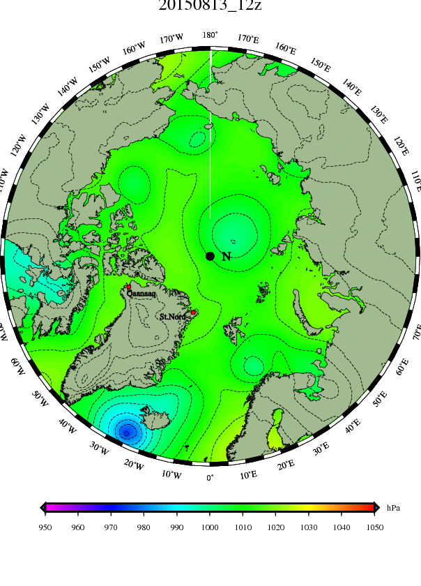
“Pohi” continues to be assailed from two sides, and to retreat down into Scandinavia, as “Beaucat” becomes the first low pressure to gain Top-of-the-world status in weeks. This is likely indicative of a change in the pattern, and we should be on the look out for new dynamics. For the time being, things are the same, with a ring of cold surrounding the Pole, centered on the Pacific side. Beaucat is a gentle, 1000mb low and nothing like the summer gales we saw over the arctic in 2012 and 2013.
“Zerve” spins north of Iceland, with a warm flow up the coast of Norway and touching Svalbard. It helps to sneak a peek at the UK Met map to understand that southerly flow. It shows that flow is full of occlusions, and largely aloft, Zerve’s front extends to a weak low north of Scotland, a weaker low west of the Azores, and then across and up to a new storm in Newfoundland. That storm, “Zerveson,” will explode to a 967 mb gale southeast of Iceland, and bump Zerve east over the top of Scandinavia, as Pohi is squished south and then bulges back north behind Zerve. This is more winter-like stuff than we’ve seen. Faboo is back to seeing the world through gray glasses.
 O-buoy 9 continues east through calm, fog, and temperatures right at freezing.
 The Beaufort Sea buoys have all been seeing wet snow on the lenses. O-buoy 10 shows the best signs of clearing at the moment, with a drop in temperatures to around -1.5°, and winds around 11 mph.
 O-buoy 11 has seen a diurnal dip to around -0.5° with winds around 6 mph.
 O-buoy 12 is drifting southeast, seeing temperatures just below freezing, winds of 12 mph, and slush.
TUESDAY EVENING UPDATE
Yesterday Faboo continued south, veering a little west, and moving 1.93 miles to 86.235°N, 8.147°W. After spending more than 48 hours below freezing it finally got above freezing at 0800Z and reached the day’s high of +0.4°C at noon, before falling back to -0.3°C at the final report at 2100Z. Winds picked up slightly from nearly calm to 7 mph.
Today it looks like we continued south west, though I expect we’ll turn right around and head back northeast if we get into a southwest flow as Beaucat approaches.
The gray views continued. (You know things are looking gray when the wan sun only comes out at midnight.)

Down towards Fram Strait the northern influences of “Zerves”, now a weakening 995 mb low heading away towards the top of Norway from the top of Iceland, may be sprawling just far enough north to effect our buoys. Neither seems to be getting any southern warmth, but light northeast winds has started shifting them south. Buoy 2015E: was at +0.27°C and O-buoy was just below freezing. It’s view of fog and dispersing ice was indicative of a shift in direction at a frontal boundary, I thought to myself as I snatched brief glimpses of open water and only a few scattered chips of ice, as I barely hesitated by the computer during a rushing day. Of course, now that I sit down to illustrate what I mean, the camera has come a cropper of a mass of ice. My ego wants to delete this picture, but Truth is watching as I type. Of I had any brains I’d wait ten minutes and post a picture with less ice. In fact I think I’ll do exactly that.
 Well, that’s not perfect, but a little better. Just ignore that berg in the foreground.
Over in the Beaufort Sea O-buoy 10 is not having much luck melting the ice from the strap in its face, as temperatures took a plunge down to -4° right in the middle of the day when they should have been rising. The strap did get blown a bit to the right, despite the fact it is encrusted with ice, so I expect the wind is rising, (though the data is being “stored” and not “delivered” at the moment. I suppose the satellite is busy at the moment, and they sometimes have to wait in line.) Notice the melt-water channel is again dusted by blowing snow on a skim of ice. I think one can safely say that surface melt is temporarily arrested, though the ice is still moving south towards open waters, and still might break up. Southeast of there O-buoy 11 has been giving weird, bleary views all day that suggest it got swept though a time warp to some other planet. It is less cold, but did show a dip to around -1°C, rather than a diurnal rise.
  Meanwhile O-buoy 12 continues south, and continues to see sub-freezing temperatures and snow.
I’m tuckered out, but hopefully will discuss the DMI maps in the morning. 

WEDNESDAY MORNING UPDATE


“Beaucat” is already weakening and only at 996mb, but is the closest thing we’ve had to a polar storm in a while. It wont make much of a ruckus, with winds below 20 mph at the highest, on the Siberian side. Towards Canada weak “Beaucatson” looks likely to split off and head down to Baffin Bay. (I’ll call the weak low in East Siberia “Chuck” because it is moving into the Chukchi sea.) The real ruckus will be “Zerveson” which is starting to blow up into a gale at the southern tip of Greenland. “Zerve” is going to wobble away weakly over the top of Scandinavia and then likely restrengthen in the Kara sea as it heads southeast. The question to me is where high pressure will rebuild, with all these weak lows around. “Pohi”, as an entity, looks like it will sink south into Europe and become an extension of the Azores high.
Milder air looks like it is getting north to Svalbard and Barents Sea, but just north of there the edge of the ice is clearly shown by sub-freezing temperatures, and perhaps some sort of weak surface front. The pattern seems very zonal, without the spears of warmth pushing right over the Pole we see in a meridianal pattern. The subfreezing temperatures form a ring around the Pole.
Faboo is reporting temperatures just below freezing via the Mass Balance buoy, and even the sunshine is gray. I think Altostratus suggests the warm air aloft isn’t all that warm.
 To the south Buoy 2015E: is reporting a subfreezing -0.35°C way down towards 77° north latitude in Fram Strait, and it also looks like it is just below freezing up at 80.5° latitude, where I-buoy 9 bobs in a gentle breeze of 7 mph and thinks about finally heading south. It continues to show highly variable amounts of sea ice. If it doesn’t support your private theory, just wait for the next picture. The second picture is interesting, as that nearest berg to the left seems to faintly show that even flat bergs can have a lot of their mass under water, which demonstrates the difficulty of measuring volume by satellite, as a satellite would have a hard time seeing the underwater part of that berg.
 Over towards the Pacific side O-buoy 10 continies to drift very slowly south with 9 mph winds and temperatures stubbornly below zero, and clouds increasing, though we did get just a peek of just-before-midnight sun.

 O-buoy 11 continues to see a smear. Winds are higher (18 mph) and it is headed south faster than O-buoy 10, so the ice in theory should be spreading out, with more open water, though temperatures remain flat at around -1°C. (That may be the temperature of the salt water, which doesn’t freeze, even when made slightly brackish by melting ice, until down around -1.7°. )
 O-buoy 12 has stopped drifting south for the moment, as winds slacken to 7 mph and temperatures settle to -3°C. We only got one half-decent picture before the freezing fog moved in.

Now the fog has lifted and the sun is blearily looking over a scene where temperatures have dropped to -3°C in the “warm” part of the afternoon.

WEDNESDAY AFTERNOON UPDATE
Yesterday Faboo turned around and drifted back northeast 1.3 miles to 86.243°N, 7.887°W. Temperatures made it up to freezing at midnight and the day’s high of +0.9°C at noon, before slipping back to +0.1°C at the final report at 2100Z. We are likely starting to feel the winds of Beaucat, which may not push us south but could drive us a ways east. It will be interesting to see if some the cold gets spun around from the Beaufort Sea side. Our view remains gray and dreary.
Buoy 2015E: is reporting -19.05°C, which has got to be a glitch. I’ll catch up with the O-buoys later.
*******
O-buoy 9 continues to mill around in slack waters and a near calm, with temperatures right around freezing. I’ll stick five pictures below to give an idea of how much the view changes. Keep in mind the view was nearly ice-free this morning. I get the sense a lot is going on in a very thin layer of stratified atmosphere.


O-buoy 10 remains on firm ice, though still drifting south. Winds have picked up to a breeze of 15 mph, and with temperatures rising during the time the sun is higher, but still below freezing.

 O-buoy 11 continues to get smeared by the blear creature of the north, which is now pressing its face against the lens for a “selfie.” Winds are nearly calm, and temperatures are up to freezing.
 O-buoy 12 is stationary, with temperatures doing a quick dip after a quick spoke up towards freezing. This picture wins the coveted “Shot Of The Day” award.
There are some impressive bergs in the distance, which I judge to be jumbled ice, and not from glaciers. They are what larger pressure ridges can become when the ice breaks up. A decent thaw can cause these bergs crumble back to their component bits and pieces, which then spread out as many small bergs. In other words, one of these jumble-bergs, covering an area of X, can become many small bergs covering an area of 4X or more. (Remember 9/10th of the jumble is underwater and out of sight.)

The DMI maps once again can wait until morning.


THURSDAY MORNING UPDATE


Beaucat stalled and cut-off on Pole. Noontime reducing the cold on the Pacific side, but the cool pool is still evident, and part of a ring of subfreezing temperatures around the Pole.
Faboo is seeing a bit of wan sunshine but not much warming yet, with subfreezing temperatures.

“We Are Now Starting To See A Dramatic Cooling In The Arctic”, Says Former NOAA Meteorologist (See more at: http://notrickszone.com/2015/08/12/now-starting-to-see-a-dramatic-cooling-in-the-arctic-says-former-noaa-meteorologist-extremely-cold-from-2025-to-2050/#sthash.uS3M3yU3.WG6wB8Wi.dpuf)
This fellow links lunar cycles to Periodic surges of milder water from the Atlantic in 1990, 1998 and 2006. The Arctic stuff starts at 17.48 of the video.
THURSDAY MORNING O-BUOY REPORTS
O-buoy 9 continues to drift southwest, which is a pity, as I was hoping we’d head east and visit Svalbard. Winds are very light and temperatures alternate a hair either side of freezing. It is so cold at O-buoy 10 that a tornado froze solid over to the left. Oh, that’s not a tornado? Well, winds are fairly brisk at least, at 18 mph, and temperatures are stuck at -1°C. The melt-water pools don’t look very melted. We are continuing south and a little east, likely in the influence of “Beaucatson” to the south rather than “Beaucat” to the north.
 At O-buoy 11 the weird, leering blear-creatures of the sleep-deprived arctic night are starting to fade like a bad dream, but we really could use a thaw and some sunshine to clear the lens. We may have touched thawing temperatures briefly yesterday, but the night dipped us back down to -1°C. Winds have dropped to calm, so the drift south has slowed, which means the ice from O-buoy 10 should be catching up and making the pack-ice more packed. Hopefully as the sun gets higher the lens will clear and we can see.
 Over to the west at O-buoy 12 the winds swung around 180° and our drift to the west shifted to the east, which apparently created elbow room and allowed the bergs to spread out. For a time this morning there was nothing but open water in sight, so I expected the temperature to rise to the temperature of the water, which typically happens, but rather than rising to roughly -1.5°C the temperatures dropped to -4°C, which made me look like a bad forecaster, and also caused me to stir up my dandruff. For the life of me I can’t figure out where the cold is coming from. (I was tempted to blame a solid expanse of ice out of sight, directly behind the camera.)
What it means is that all the open water you can see in this picture is being chilled at a time it theoretically should be being warmed. Not that the sun could do much warming, even if it wasn’t cloudy. Because it is just past midnight local time, and we are down at 77.5° latitude, the sun is so low on the horizon that water reflects radiation as well as the ice does, unless it is very rough, which it isn’t, with winds at 2 mph. Conclusion? Beaufort Sea is being chilled as we watch.
THURSDAY EVENING REPORT
Yesterday Faboo only made it north to 86.245°N, before the west winds swung from WSW to WNW, and we moved in stronger winds than we’ve recently seen, steadily 11 mph, to 86.227°N 6.838°W, which is 4.88 miles from where we were yesterday. Temperatures defied the diurnal norm, reaching a high of +0.4° at 0300Z and then sinking to -0.6°C at 1500Z as a low.
Today the SE drift likely continued, as the weak low over the Pole swung a sort of front over, giving us a spell of freezing drizzle and then, at long last, some sunshine, though it didn’t raise temperatures. The final picture is from just before midnight, local time, and the unofficial temperatures were dropping to -1.85° C. This demonstrates that the warmth of slush season has past, and clear skies don’t automatically mean temperatures cause thawing, especially towards midnight. (Notice how much of the sun is reflected from the old, gritty snow, and think whether you require sunglasses as much as you will in a picture-to-come of sun glancing off glassy water.)


South of there O-Buoy 9 stopped drifting west and started back east, while nudging south closer to 80° latitude. Here too temperatures dipped when it cleared, and here too we happened to see the sun close to midnight. This coincidence is totally cool, because it demonstrates glassy, open water reflects a lot of light when the sun gets low, but not all the light, until the sun gets even lower and sits on the horizon. The question for you, dear reader, is, “Which better reflects sunlight? Old snow or glassy water?” Which requires sunglasses more? The following picture wins today’s award for “Most Beautiful Picture.” It was taken three hours later, the other side of midnight, but the sun has seemingly moved the wrong way across the sky and is now out of sight to the left. This is because the camera is swinging around, panning to the right. This picture is loaded with cool stuff that fascinates the scientific mind, but it is worth simply opening it to a new tab and gazing at the beauty like a stupid poet.
OK. Enough of that happy hornswaggle. Now lets be amateur scientists and notice the neat stuff. Have you ever seen bergs as brown as the ones in the distance? Don’t you crave to go sample the dirt and take it to a lab for proper analysis? And how about that skim of ice on the sea-water in the foreground? How cold must that water be, to freeze so quickly after temperatures barely nudge below the freezing point of salt water? (Answer: Very cold.)
South of there down in Fram Strait, Mass Balance Buoy 2015E: is reporting a likely-incorrect -12.46° C. Likely the buoy is under attack by the dreaded arctic blear-creature, which distorts reality. Less likely is the possibility that the read-outs from this buoy are automatically fed, via satellite, into a computer model costing the taxpayers of Lower Slobovia six ka-zillion Slobovian Burros. Because this incorrect reading is like a butterfly flapping its wings in the face of Chaos Theory, they are currently evacuating the Sobovian capital, because their computer model is predicting winds of 300 mph for tomorrow’s rush hour.
Turning our attention across the Pole to the Beaufort Sea and O-buoy 10, it is with complete horror I must report it now has been pounced upon by the blear-creature: This occurred because the blear-creature had to flee O-buoy 11, who heroically fought off its leering, smearing effects and gave us a visual, which is interesting because there is so much fresh snow and so little open water.
Further west O-buoy 12 must be seeing a wind-shift to the south, as it has started drifting back north, but temperatures have only risen a half degree and still remain below the freezing point of salt water. The water in the foreground in the picture may have an oily look because salt water looks oily, when it first starts to freeze.
The DMI maps show a changed arctic, in terms of isobars, though it looks much the same in terms of temperatures. The Pole remains ringed by colder temperatures, with the cold pooling on the Pacific side. Where we had high pressure “Pohi” over the Pole, with a long fetch from Siberia to Greenland, we now have the weak low pressure “Beaucat.” “Chuck” is the weak low north of Bering Strait. “Beaucatson” has dipped to Hudson Bay, leaving the weak low “Beaucathree” behind. “Zerve” is also weak and drifting east north of Norway, with “Zervezip” kicking ahead and diving down as a weak low into Kara Sea. The only decent storm is “Serveson”, the gale southwest of Iceland.

“Pohi” in the above maps has been pushed all the way south to Sweden, which allows me to write an analysis I proudly title:
LAME EXCUSE FOR BOTCHED FORECAST
Thise who put up with me know that last spring I thought, due to the state of the PDO and the AMO, that the Pacific side of the Pole would be warm this summer and the Atlantic side would be cold. In my attempts to salvage some credibility, I have noted that while the Barents and Kara Seas may not have been colder, Scandinavia was.
Today, on his excellent blog at Weatherbell, Joseph D’Aleo shared some insights about the Scandinavian situation, and in the process gave me a computer model’s hopeful idea that the Norse might actually have some summer this summer, over the next 20 days. Of course, I care more for sea-ice than gorgeous blonds, (when my wife is watching), so I was looking north of Scandinavia when Joseph D’Aleo shared the following maps of the next ten days, and the ten days after that.
 This is only a computer model’s idea, and not reality, but such warmth in the northeast Atlantic is something well worth being wary of, if you watch the melt of sea-ice, which I never waste my precious time doing….but only indulge in when it repays me many times over.
FURTHER INSIGHTS ON EUROPEAN HEAT
The heat surging north in Europe, and to a lesser degree on the west coast of North America, may be the warm aspect of a meridianal flow bringing cold air down to Iceland.
I have been thinking to myself that the low pressure bombing out by Iceland looks a lot like an Autumnal gale, when it isn’t autumn yet. Apparently I’m not the only one who noticed. This German meteorologist’s comment is well worth thinking about, and his linked paper is well worth reading, (though the auto-translate butchers it a bit.)
“Well said. May I contribute a confirmation of Dilleys speech from an entirely different direction? Every synoptical meteorologist should have noticed that there is an extraordinary series of most intense low pressure systems on the Atlantic. Just today there is one with core pressure below 975 hPa! In average this happens every five years ONCE in summer, but a sieries like this one I never experueinced in more than 40 years of work as a bench forecaster.
The intensity, amongst other phenomena, depends on the temperature difference between high and low latitudes. The bigger the difference, the stronger the low pressure systems. Thats why in winter this is a regular phenomenon – there is much more seasonal variability in the arctics than in the tropics. If there is a series like this occurring in summer, there is just one conclusion: it must be extraordinary cold in the arctics this summer! This must not necessarily be mirrored by sea ice cover instantly, but wait for the next few years.
More information about this can be found in my article (in German) over by the EIKE here:
http://www.eike-klima-energie.eu/news-cache/bemerkungen-zu-den-hitzewellen-2015-in-mitteleuropa/ “
Hat tip to “Craigm350” at https://craigm350.wordpress.com/
FRIDAY MORNING UPDATE
The “last in a series of storms” mentioned above is what I’ve dubbed “Zerveson” and can be seen south of Iceland, where it is already past peak and has weakened to 960mb. It is interesting to me that “Pohi” is rebuilding a weak ridge of high pressure from Scandinavia up over the Pole, behind “Zerve” as it dives down through the Kara Sea into western Siberia. This weak ridge is nudging weak Beaucat off the Pole. Warmth has surged north to Svalbard, Barents Sea, and to Kara Sea, but just north of there a wall of sub-freezing cold is resisting.


Faboo has experienced a shot of air down towards -2°C, and “lake Faboo” to the right is definitely frozen over. O-buoy 9 caught a view of the dirtiest berg I’ve ever seen. Perhaps someone was planning a garden up there this summer. Light winds are swirling sub-freezing air with air right at freezing, making a jagged temperature graph, but the second picture shows the “oily” water indicative of salt water trying to freeze. We are right on 80° latitude, and have started back east again.
 O-buoy 10 continues to show the blear-monster, (do not confuse a polar blear with a polar bear.) Temperatures have made it up to freezing, and winds are 5 mph.
O-buoy 11 has winds of 9 mph, temperatures roughly a degree below freezing, and takes a dim view of the situation. Lastly O-buoy 12 attempted a thaw but only made it up to -0.5°C before dipping back a bit, with winds around 10 mph. We’ve drifted northwest a hair, which suggests southeast winds and a chance of thawing. If you squint at the water by the ice in the mid-distance I think you can glimpse varying depths of underwater ice, which suggests the ice we are looking at was once (perhaps last summer) broken bergs of various sizes, and then frozen together into a single slab. Just an idea.
  FRIDAY NIGHT UPDATE
Faboo curved from southeast to southwest yesterday, getting as far east as 6.578°W, and traveling 4,13 miles to wind up at 86.167°N, 6.804°W. Winds slacked off a little, from 11 mph to 7 mph. Temperatures went through a nice thaw and then a refreeze, with the day’s high +0.7°C at 0600Z and the low at -1.4°C at 1800Z. (Diurnal variation be damned!)
The unofficial reports and pictures indicate we have continued to inch southwest, and temperatures have continued below freezing despite some sunshine. Whether we make it down to 86° latitude in the near future depends on whether “Pohi” builds a ridge to our east or to our west, and currently models show us smack dab in the middle of the ridge, which likely means we’ll go nowhere, and be slow about it. We’ll see.
 To the south O-buoy 9 continues southeast in a light breeze of 7 mph through varying temperatures slightly below freezing. It also continues to produce a kaleidoscope of sea-ice pictures, each one worthy of examination, but if I posted fifteen pictures and went on and on and on about them I might come across as a tedious old man, rather than the dashing and dapper character I’m striving to be, so I’ll just post the latest.
 Across the top of the earth and down in Beaufort Sea I’m expecting a warm-up, because the circulation around “Beaucat” theoretically should pull cold air from the Pacific side to the Atlantic side. This is “sharing the wealth” and politically correct, and only incorrect people would call it “robbing from Peter to pay Paul,” and suggest it doesn’t pay in the long run. But first let us check to see if it actually happening.
O-bouy 10 has shaken free of the polar-blear, and gives us a view of fresh snow with little wind, but Huzza! Huzza! We’ve made it up to thawing! True, it is only +0.02°C, but let’s not get greedy. If you are greedy, head southeast to O-buoy 11, where a sad situation has developed. Despite marriage counselling, the co-located Mass Balance buoy 2014I and O-buoy 11 have drifted apart. (Please don’t sob; it helps no one.) But the good side of the seperation is if you don’t like one temperature you can take the other. The O-buoy may be reporting temperatures right at freezing, but the Mass balance buoy has reported a noteworthy rise from -0.64°C to +1.49°C.
In the picture we see fresh snow that does look like it is wilting a bit, and could pack a mean snowball, however the pack-ice looks more solid than I would have expected, considering it should be melting and breaking up. When we go west of there to O-buoy 12 we get to a view that is, to me, rather annoying. After all, this buoy is closest to the mild Pacific and should be showing the most melt. I predicted it, and I’m sick and tired of this dumb buoy making an ass out of me. Temperatures actually have risen and flirted with freezing a a bit, but instead of soggy snow and slush and dissolving bergs, we get a wrongful photo of a freezing sea.
 The skim of ice on the salt water is obvious in the foreground, but less obvious is what is in the water just beyond that skim. At first it looks like dappled water, but when you squint at it you see the painter didn’t do a very good job of conveying what dappling looks like, and then you suddenly realize it isn’t dappling; it is tiny little “pancakes” of ice.
This is actually the second stage of ice formation. In the first stage the water has an oily look, due to fine partials of ice floating like microscopic icebergs, but then they start to coalesce into larger and larger pancakes. This is a neat picture for a textbook.
I wouldn’t mind it if this was happening in the cold water up by Greenland, but it shouldn’t be happening down here at 77.85° N. According to me, this water is warm PDO Pacific water that melts bergs from beneath. It has no business acting cold enough to form pancake ice, and IMHO should go back to school and learn what is proper behavior.
At least the Mass Balance buoy is reporting we have inched above the freezing point of salt water here, to -1.11°C, so perhaps the pancake ice will melt, and I’ll only look like a mule, rather than an ass.
The DMI maps show that despite the efforts of both Beaucat and Zerve to push Pohi down into Eurasia, Pohi was a tricky little high pressure, and oozed like an ameoba under their attack and now is extending back north behind their backs, and is strong enough to keep Zerveson stuck by Iceland. The question now is how the nose of Pohi, extending towards the Pacific, will deal with the weakling Chuck, over on that side. Some models show Chuck will not remain as weak as he appears.
Meanwhile the temperature maps continue to show a pool of cold on the Pacific side, despite the efforts of Beaucat to swing some of that reservoir of chill over the Pole towards the Atlantic.


SATURDAY MORNING UPDATE


“Pohi” looks like it expanding back up to the Pole, pushing “Beaucat” towards the Siberian coast. It is one big game of “King of the mountain.” I wondered if Pohi was making it nice and sunny up in Svalbard, so I headed up there to have a look.
It looks surprisingly gloomy to me. Pohi holds a fair amount of moisture.
The subfreezing air rings the Pole, and seems more evenly distributed than last week. I’m waiting to see if weakening “Chuck” creates cold over the Beaufort Sea.
Up at the Pole it is bright, sunny and cold, with the unofficial Mass Balance buoy reporting temperatures down to -1.45°C and Lake Faboo looking both frozen and shrunken, as if the water under the surface ice is percolating downwards through the foundation ice.
 To the south O-buoy 9 is moving east past 4.4° longitude with temperatures a hair above freezing and winds at 7 mph. Another filthy berg floated past earlier, but the current berg is a blue eyed blond.
 O-buoy 10 has made it down to 76.5° latitude, with calm conditions and temperatures just below freezing. The ice still looks fairly solid.
 O-buoy 11 is seeing the ice spread out again. It saw a slight thaw, but not the warmth of +1.49°C that Buoy 2014I: saw. It has dipped back below freezing, as Buoy 2014I: has dipped to -0.64°C. Winds are nearly calm.
 O-buoy 12 was seeing the temperatures below freezing but not below the freezing point of salt water, and the slush in the water is getting melted. Available heat was being used up on new ice when it should be busy with the old. However no sooner had I noted that on another post, (first picture) when temperatures crashed to -4° and snow hit me in the eye (second picture). I swear this camera is out to get me.

I think a pie-in-the-face makes a fine conclusion to this post. As my youngest son is graduating from college, I’m not sure how diligent I’ll be able to be, starting the next one, but I’ll do my best.

Grateful you’re still writing! Love the true insight, I share all your posts. Thank you!.
Thanks for the appreciation, Sarah. It was just what I needed on a gloomy day.
It’s not very smart to rely on a single measure of Sea Ice Extent as a proxy for the amount of arctic sea ice, which is measured in volume. People who have been monitoring the arctic for years with satellites are commenting that the ice-pack does not seem to be in a very strong state this summer. In other words, it looks like that the “recovery” in amount of arctic sea ice (volume) has stopped. We will know by the end of September.
Volume actually had little to do with the “Death Spiral” theory, which was over-focused on area, because that was what reflected the sunlight. The premise of the theory was that the seas would absorb more heat because there would be less of an area of ice reflecting sunlight. Volume didn’t matter. I think it only has come to matter because the theory now seriously needs a back up plan.
Volume is indeed important, in terms of measuring the total amount of ice. However there are huge problems when it comes to measuring it, especially from afar by satellite. That is one reason I stress an up-close view at this site. Very often we see things the satellite can’t.
The next 45 days will be very interesting. Pay close attention to the ice that is already broken up, and forms areas of less than 90% concentration. On 2012 it all melted quite swiftly. In 2013 it bumped about and hardly melted at all. What will it do this summer?
once again thank you for putting the effort into this blog post caleb, it is much appreciated.
over on the asif i saw mention of rain, i think the o bouy cameras are likely to continue to show fresh snow as opposed to rain.it just is not warm enough for rain,of course if people are looking at temperatures a few thousand feet up,it is easy to understand the confusion.
O-bouy 10 did show some freezing rain or drizzle on the strap hanging on front of the lens, which does show it was warm aloft and then colder down on the surface. It also showed a melt-water pool frozen over and then dusted with snow, which emphasizes how cold it is on the surface. I have to trust my lying eyes.
cfgjd. that would be correct if we actually measured volume. go read the long term commentators at the arctic sea ice forum and you will see while they are interested in various metrics ,they largely understand the limitations of trying to measure volume and the issues the models have with coming up with something meaningful.
the images caleb show with frozen over leads are a prime example where satellites will show no ice . the resolution of the various satellites differs and i strongly suspect other than radarsat 2 (which has 100m resolution) any sea ice in the regions like beaufort which is broken up ,showing up as even a small white dot has to be at least 2 metres thick to be visible at all.
there also appear to be significant issues with all the various sea ice monitoring groups this melt season,with some issuing notices to highlight this. currently dmi has been experiencing issues but has managed to get the 30% chart back online but has yet to do the same with the 15% extent chart.
nsidc,jaxa etc all appear to be currently suffering issues,it will be interesting to see where we are when or if these issues get sorted out. who knows, maybe if te ice does track the right way in the lead up to paris the problems might result in no official minimum extent issued 😉 (sorry for the cynicism caleb,i have every faith in the people doing the work in these various groups, however the group leaders and directors are a whole different proposition)
Here are many recent SAR images of the arctic: http://www.polarview.aq/arctic
Thanks for the link!
The reality check was the pictures from the ice-breaker in Hudson Bay, because no satellite showed 100% ice, nor ice as thick as that shop was plowing through.
The “death-spiral” I have seen is for the PIOMAS volume. Volume is the right thing to track but yes, it is difficult from space and yes, PIOMAS is only a model. Cryosat gives a reality-check every winter.
nope, cryosat 2 is better than what was used previously to judge volume, but it i still nowhere near the actual reality of true arctic sea ice volume.
Care to quantify that statement? There’s not a shadow of a doubt that there’s a helluva lot less ice (volume) these days than 10/15/20/25/etc. years ago.
i agree,there is less ice than 10 to 25 years ago cfgjd . there is more than there was 3 years ago though.
next year there may be less, the next year more etc,but as caleb so eloquently points out ,the death spiral theory as originally stated is toast.
this is worth a read in relation to the issues facing the scientists when it comes t measuring volume. http://www.the-cryosphere.net/8/1217/2014/tc-8-1217-2014.pdf
hi caleb. the issue with the 30% dmi chart is now resolved. there was nothing wrong with the 15% chart. just my eyesight failing to see the u of aug on the display was on the middle of the month 🙂
nice guys to converse with, thanks to google translate .
Thanks for all the interesting information. It is great to listen to commentary that isn’t just propaganda for the alarmist crowd. Maybe there is less ice than 10-25 years ago, but was about 1920-1955?
Volume-trend is still strongly down and it’s probable that the “recovery” since 2012 has stopped or even partially reversed. Cryosat works well but is of course not perfect, and does not even need to be. Here’s PIOMAS with July 2015 update:
any volume metric of arctic sea ice is modeled ,therefore while it may provide information on a trend, it is not very accurate. i would certainly doubt the capability of any volume model to accurately depict volume differences between last summer and this summer for the central arctic basin for instance.
just as the reduction in extent was full of ups and downs over the last 30 years or so,it could well be if we are passing the peak of warm oceanic cycles any increase over a period of time would see the same fluctuations within a general trend.
Attempting to model the volume of a ka-zillion bergs of various thicknesses bobbing about the Arctic Sea is like trying to count ants with a hammer. The bergs you miss will bite your butt!
excellent funny analogy caleb, i will remember that 🙂
Clutching for arctic straws is an increasingly futile exercise and can it appears become an embarrassing obsession.
Roger,
You’ll probably like the embarrassment I point out in Hudson Bay, that I just posted.
PIOMAS and CryoSat-2 together can do pretty well. This is way way better than trying to make guesses based on satellite-based Sea Ice Extent – proxy. We KNOW that the ice up there is not in great shape.
Is it rotten? 😉
did you read the paper i provided a link to in a previous comment cfgjd ? together they may do better ,but extent is still the most accurate measure we have over the satellite era .
If you mean that the error-bars are smaller on Sea Ice Extent than in Sea Ice Volume you are certainly right. However, volume is a direct measure for the quantity of ice and area/extent are just proxies.
How do they get a direct measurement? Surely they don’t have an intern up there with a tape measure, going from berg to berg and diving beneath them in a wet-suit.
Sometimes I argue by reducing to absurdity.
two points cfgjd . one neither volume nor extent/area tell us much about the density of the ice.this is a fairly important aspect when it comes to ice of any age/thickness .
secondly ,sure , directly measuring volume would tell us a lot about volume. the problem is, no one is directly measuring volume.
That’s a great and sobering video you found. Thanks for your persistent efforts! I bookmarked it for later comprehensive viewing. This completely agrees with the prognostications of Mr. John L. Casey, author of “Cold Sun”, and others like Abdussamatov as well. Keep up the great work, because too many people have been persuaded to the opposing views on climate, the reality of this is going to be for them like hitting a brick wall at full cruising speed!
“Sobering” is right. I actually hope the sun changes its mind and blesses us with a “climate optimum.” However perhaps people need a cold slap in the face, to be woken up.
Interesting comment. Relates to Serveson –
Thanks. His observations are very interesting, and I’ll post a link to his paper. (And I did think that low by Iceland did seem to be bombing out like an autumnal gale, when it isn’t autumn yet.)
all that energy heading towards the poles is only going to result in one thing in the long run caleb,cooling. it may well melt some ice on the way,but whether by the ocean or atmosphere ,energy heading to the poles is taking the short route to escaping from the atmosphere.
I agree. I also think the pattern looks very lopsided and unlikely to be able to sustain itself. I’ll be expecting things to flip about into some unknown (at this time) new and interesting configuration.
looking at the north atlantic oscillation index for july at the bottom of the page (why do i think if it was some measure that could be spun to intimate warming it would be at the top ? maybe i am too cynical ) it is at minus 3.18 . https://www.ncdc.noaa.gov/teleconnections/nao/ i believe this is the lowest i have ever seen it ,and is indicative of those 5 severe low pressure systems that you highlighted in the link above.
worth keeping an eye on in the coming months.
Thanks. Interesting link