
With sun arctic sun at its highest, and shining 24 hours a day, we are actually at a point where the Pole gains energy, albeit only a small amount. Therefore, in theory at least, the Pole could even be seen as a “source region” of warming, rather than cooling.
In actual fact the Pole remains a source region of cool air, as there happens to be an ocean covered with bergs in the way of warming. Things might be different if there was a low, flat island (not 10,000 feet tall like Greenland or Antarctica’s icecaps) at the Pole, baking under the 24 hour sun, however that belongs to the realm of fantasy, and the reality is reality.
Besides the icebound ocean there are some other factors creating cold, or at least cool, air. A lot of heat gets gobbled up simply melting the ice into summer slush, as the available heat becomes latent heat in the phase change from solid ice to liquid water. Also any time it tries to snow or rain evaporative cooling may occur as the precipitation falls through the often-arid arctic air. Lastly, there may be heat lost from the tops of clouds through the tropopause to the stratosphere, as the tropopause is lower in the arctic,.
There is actually a lot of debate about whether or not storms lose heat. It might seem to be common sense, for when one thinks of a thunderstorm on a hot day it seems the storm obviously cools things down, but when it comes to doing the math it doesn’t add up. I myself have never been all that good at math, and have to take it on faith that it doesn’t add up, but I also keep scrutinizing the situation, thinking an yet-unobserved factor might be involved. (For example, a cloud has a flat bottom but a triangular top, so perhaps it has more upward-facing area with which to lose heat than downward-facing area to reflect heat downwards).
All that being said, it does get quiet up in the arctic in June and July, as there are not the cold air-masses needed to clash with warm ones, to brew up big storms. While this may make things boring, it may also offer us a chance to observe subtle effects that are usually hidden or swept away by the powers of larger and more wintry storms during the ten months the arctic is definitely a cold-creator (or actually a heat-loser).
I like to carefully watch the weak storms that drift about the arctic, and to watch the below-freezing temperatures they seem to create. Officially there should be no created cold with the sun so high and powerful, but over and over one sees the cold appear out of the blue. It is something to ponder.
Currently a weakening storm I dubbed Klyuchi (after a small Siberian city) has drifted across the Pacific side of the Pole to the Canadian Archipelago, and the storm trailing it, dubbed quite logically “Trailor”, is being deflected south to a crossing route down near Being Strait. On the Atlantic side things are quiet, though something is brewing in the Baltic Sea and may come north later in the week.


It seems to me Klyuchi did create some cold, as a few small patches of sub-freezing air have appeared even in the afternoon heat, on the Canadian side.

Although the sun never sets on the sun-baked Alaskan coast, it does get quite low at midnight, and temperatures at Buoy 2015A, which have been as high as +7.0° C, have recently dropped to -0.13° C.

Far out to sea to the north and west, Buoy 2015B was also reporting thaw, but has dipped below freezing to -0.18° C

North of there O-buoy 12 is exactly at freezing, with the melt-water pool at the left starting to erode at its edges.

Back to the east across the Beaufort Sea O-buoy 11 is also exactly at freezing.

It is interesting that these cold temperatures are all south of 80 degrees north latitude, and not included in the DMI graph of polar temperatures.

As you move towards the Pole you are actually moving into high pressure, with fewer clouds and milder temperatures, and our North Pole Camera getting above freezing again. By 2100z on the 21st the camera had progressed 4.1 miles southeast, riding a steady wind of around 10 mph, to 87.006°N, 3.093°W, and its temperatures had yo-yoed from -1.4°C at midnight to +0.7°C at noon and back down to -0.3°C at 2100z. (Today’s unofficial report has us down south of 87 degrees latitude at long last, with temperatures up to +0.13° C.)

Down off the north coast of Greenland O-buoy 9 is drifting east again, nearing 15 degrees longitude, and temperatures have briefly spiked above freezing.


TUESDAY EVENING UPDATE —Faboo slows—
In case you are wondering what the word “Faboo” means, I just coined it, because I’m tired of writing “Faithful North Pole Camera Buoy.” It will be our little secret, and knowing what “Faboo” means will mean you are among the select. We elite few who know what “Faboo” means will be able to adopt a pitying, condescending tone, and say things such as, “The poor fellow doesn’t even know what, ‘Faboo’, means.”
I am fond of Faboo, because it was the first camera I knew about. Years ago it introduced me into the mind-boggling reality of using my own eyes, rather than trusting the mainstream media, when it came to understanding the arctic icecap. I am grateful to the people who created the idea of the drifting arctic camera, because when they created Faboo they created something unlike the media, unlike politicians, and unlike all too many scientists. When they created Faboo they created honest views.
In any case, I tend to focus on Faboo even though he is now just one camera among a seeming throng of Johnie-come-lately-copy-cats. I figure Faboo has earned my loyalty, (unless-and-until some politician demands it start portraying palm trees on the ice.)
Faboo’s official reports tend to be delayed a day, but are neatly recorded at three-hour-intervals here: http://psc.apl.washington.edu/northpole/PAWS923840_atmos_recent.html
You can get more up-to-date reports at the Mass Balance-Buoy home page at http://imb.erdc.dren.mil/newdata.htm where Faboo is called “Buoy 2015D”. (The problem with this site is that they don’t bother with time-stamps.)
Faboo has continued to slowly drift southeast, but its speed has slowed as the wind slowed from a steady breeze around 10 mph to a near calm. It ended the last report (2100z June 22) at 86.961°N, 2.783°W, which is 3.3 miles further to the southeast, but still roughly 150 miles north-northeast of where we were at this time last year.
Faboo’s temperature antics are a bit amusing, when you consider the fact temperatures basically stayed the same, varying barely more than a degree. Where I live there would be little fuss if temperatures varied between 74° and 75° Fahrenheit, but when that degree moves across the freezing point it makes a huge difference, especially if you are an Alarmist and feel a thaw is proof the North Pole is melting and the End Of The World is coming, but a refreeze means you are plunged into abject despair because the world isn’t going to end and you have to get a Real Job. In fact, each time Faboo quirks above freezing I imagine Alarmists wildly cheering, and then when it dips below freezing I imagine the cheering abruptly cut off.
Mother Nature was toying with the poor Alarmists on June 22, for at 0300z temperatures were at -0.3°C, and at 0500z rose to +0.2°C, (wild cheering), but then at 0900z fell to -0.7°C (dead silence). Later, at 1500z temperatures were at -0.5°C, and at 1800z rose to +0.3°C, (wild cheering), but at 2100z had fallen to -0.6°C (dead silence).
Of course, Skeptics can cheer in an equal but opposite way, and be just as silly. The way to avoid being emotionally jerked around by Faboo’s thermometer is to remember that temperatures are suppose to be above freezing at this time of year. In this way you don’t get all depressed about thawing, but every freeze is an unexpected benefit.
The unofficial report gives us a reading for Faboo of +0.73° C, which might make the Alarmists happy, were it not for the fact every other Mass Balance Buoy is currently reporting freezing or below. (Likely this is just a fluke of the record-keeping, but when it comes to Alarmists and Skeptics, all is fair in love and war.)
On a more scientific note, it does seem the fading-away of Klyuchi on the Pacific side has made temperatures colder over there than they were.

WEDNESDAY UPDATE —Faboo reverses—
Faboo made it as far south as 86.960°N at midnight yesterday, but then edged back north and west, winding up at 86.964°N, 2.911°W at 2100z, which is 0.51 miles back the way we came. In the light southeast winds the temperatures nudged up to +1.0°C at 0900, before sliding back slightly to +0.6°C at 2100z.
The light southerly flow exists due to a ridge of high pressure developing between the remains of Klyuchi and Trailor on the Pacific side, and a storm brewing up in the Baltic in the Atlantic side, which I suppose I’ll call “Balt.” Balt looks like it will weakly roam east along the arctic coast of Eurasia, and the high pressure will persist over the Pole, likely keeping Faboo from moving much for a while.
 It seems the persistent gray weather at the Pole is at long last giving way to a more sunny spell.


The low midnight sun is not warming much in the Beaufort Sea, likely because of clouds and possibly because of snow.  It has warmed up on the coast of Alaska, with Buoy 2015A reporting +4.09° C, but once you head out to sea it gets colder. The only other above-freezing temperature is at Buoy 2014I: which is co-located with O-buoy 11, and shows it is just barely thawing at +0.03° C. The melt-water puddles are holding their own.
 At other buoys it is colder. Buoy 2015B: is reporting -0.09° C, Buoy 2014G is reporting -0.79° C, and Buoy 2014F: is coldest at -1.33° C. O-buoy 12 looks like it might be experiencing some snow, with temperatures right at freezing.
 Considering we are well into the season of thaw, conditions seem a bit cold up on the ice. Perhaps once the low pressures die away on the Pacific side we can get back to sunshine and thawing, but at Buoy 2015E: , way down at 79.53° N, 0.84° E, at the edge of the ice in Fram Strait, it is -0.44° C, which seems to hint at a colder Atlantic.
THURSDAY MORNING UPDATE —Faboo back north of 87° latitude—
The morning map shows Klyuchi drifting down towards Hudson Bay, as Trailor stalls north of Bering Strait. Balt is slowly drifting up through Scandinavia. Between the lows is a ridge of High Pressure to the Eurasian side of the Pole, giving Faboo south winds and nudging the ice it sits upon back north. 
In these 0000z maps it is midnight down in Fram Strait, so you expect a bit of chill as the midnight sun sinks down to the horizon at 78° south latitude. but it is noon at the top of the maps, so you don’t expect the cold, sub-freezing temperatures towards the top, but there they are. When the wind shifts up at the Pole, and a huge area of ice stops moving one way and starts back the other way, you can expect pile ups and cracks and the formation of wide leads. The ice still looks fairly solid in Faboo’s view, but there may be a thread-like line of sun shining on water in a lead on the farthest verge of the central horizon.
 The view from o-buoy 9 is far more dramatic, as a wide lead opened up. Apparently some the ice has continued on to the south as the ice our camera sits upon put on the brakes.
  Our camera here may be in danger when the lead closes and the ice slams back together again. Keep your fingers crossed.
O-buoy 9 is still to the northwest of the final north-thrusting peninsula that Station Nord is situated on. Once we are past Station Nord we’ll likely head south. Currently the camera seems to have swung around and be looking more to the west than we were. When we were looking due south we could see the mountains of Greenland passing in the distance.
QUICK EVENING UPDATE
The Faboo official records have been updated, and show that as oif 2100z last night Faboo had moved 2.48 miles back to the north-northwest, and was at 87.000°N, 2.934°W. (It made it as far west as 2.992°W at noon yesterday, but has begun creeping back to the east.) Temperatures have remained above freezing throughout the past 24 hours, achieving a high of +0.9°C at 1800z. ( The unofficial updates from the Mass Balance Buoy show we remained above 87° latitude today and temperatures fell below freezing.)
QUICK FRIDAY MORNING UPDATE
The unofficial update from the co-located Mass Balance Buoy tells us Faboo has continued to crunch north, and has reached 87.08° north. This is no easy task, when you consider how concentrated the ice is to the north. It is not a single berg drifting, but an enormous mass of ice that all has to be budged northward for any of it to shift.
Temperatures have just nudged back above freezing, to +0.05° C, after spending roughly a day below freezing. The ice beneath Faboo remains 2 meters thick, and hasn’t yet started to show melting from beneath, though the snow has thawed atop the ice.
Klyuchi is down over Hudson Bay, with Trailer finally starting to fade into Alaska. Balt is drifting east across Barents Sea. High pressure still rules the Pole. A decent summer storm will prowl around south of Iceland, without going anywhere, for a while. With things fairly stagnant, the model runs vary wildly in what they see the future holding, because a small thing can make a big difference. If someone sneezes in Sweden the models total change their predictions.
 .
.
Temperatures seem to be starting to warm back up on the Pacific side. Of course, it is noon over there in the map below, and midnight down in Fram Strait.

Things grew all gray again for the past 24 hours at Faboo, but a gray sun is now peeking through.

Down at O-buoy 9 off the north coast of Greenland temperatures have spiked up and a thaw is occurring. The lead seems to be closing. I’m nervous the ice may crack right at the cameras feet
Over in the Beaufort Sea O-buoy 11 is showing temperatures at +0.10° C, but the melt-water pools aren’t expanding much. The yellow trash can seems to catch sun and create its own pool, and is starting to tilt more.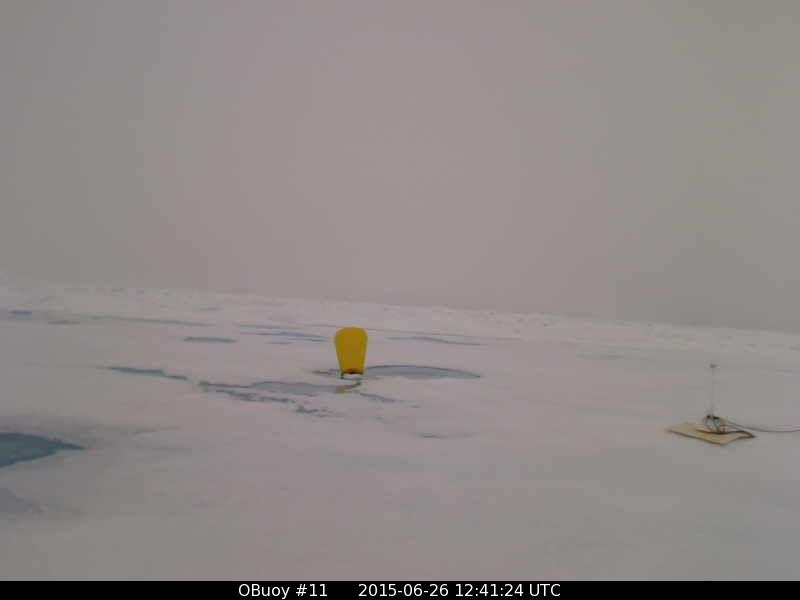 Furthest west, O-buoy 12 is resuming its thaw, but its melt-water pools hold slush from recent snow.
 I’ll likely conclude this post with Faboo’s official report, tonight. Likely it will show we made very little progress at all, towards Fram Strait, the past week.
EVENING REPORT —Faboo’s failure—
The evening report is in, and it shows that as of 2100z last night Faboo had regressed to 87.060°N, 2.391°W, or 4.57 miles to the northeast. In fact, when you consider that back on June 18 at 1200z Faboo was at 87.056°N, 4.765°W, it becomes apparent we are dealing with a serious backslider here. In an entire week we have not made a bit of progress south, and are in fact .004° north of where we began.
Now I’m sure some of you well tell me to be gentle, and will point out that over the past week we did progress 8.4 miles, but it is to the east. Others will hasten to point out we did make it down to 86.960°N at midnight on the 23rd, but that makes the backsliding look all the worse. And while I hate to sound harsh, the unofficial Mass Balance Buoy report suggests we are continuing in the wrong direction, and are up past 87.090°.
This is a serious situation, and I think it is high time to have a talk with that sea-ice. The reputations of highly something Climate Scientists are at stake, and both a Pope and a President could wind up looking like they both have fudge for brains. We simply can’t have the sea-ice gallivanting about and compressing and refusing to spread out and dissolve. It is even starting to effect the “extent” graph, which is refusing to plunge in the alarming manner it should. If this keeps up people will start to wonder if the NWS/NCEP/CPC model might be correct, and we could see above average ice extent by mid July. (Click to enlarge and clarify)
 I doubt this model will prove true. For one thing, if you compare it to how it looked at this time last year, it is nearly identical. It fooled me last year, but once burned twice shy. Last year it kept delaying when the extent would be above normal to a later and later point in the summer, and finally, in September, said, “Never mind.”
At this point it seems Faboo will lose the race to Fram Strait, and will suffer the humiliation of being beat by O-buoy 9, which actually began its journey on the other side of the Pole. It currently has slowed, but still seems to be grinding east along the north coast of Greenland. The lead that had opened and was wide seems to now be crunching shut.

On the Pacific side “Follower continues to weaken, as a follower of Follower, hence “Folfol,” appears in the Laptev Sea. “Balt” continues to nudge west towards the Kara Sea, but the lows are rather lazy, and none seems to want to budge the high pressure from the Pole at this point. As the sun dipped down to a midnight sun low on the Pacific side, some sub-freezing temperatures did appear over that way,
 All in all it seems the Quietude will continue, unless someone gets up there and gives that sea-ice a good talking to. As I am a bit busy this weekend, I elect you for the job.

Saw this was up and came to see you already found it: http://psc.apl.washington.edu/northpole/NPEO2015/NPEO2015_webcams.html
I like their daily updates of where the camera is drifting.
http://psc.apl.washington.edu/northpole/PAWS923840_atmos_recent.html
The past day it has headed back to the north. This does not bode well for those rooting for a low ice extent, as one way to get a low extent is to flush ice south through Fram Strait.