
NYC hit 90 again, so the dreaded “heat dome” persists, but it is being nudged south by a more zonal flow to the north. This flow always fascinates me, for it is a summer feature and has no true arctic component.
We are at the heart of a sixty day period where the Pole actually receives more sunshine during its 24 hours of sunshine than the equator receives during its 12 hours of daylight. We would see warm fronts coming down from the north, if it it were not for the enormous amounts of sea-ice which must be melted first, in Hudson Bay and the Arctic Ocean. Even so, the north loses its power. Arctic fronts are now called polar fronts, and currently one struggles to push south of Hudson Bay and Newfoundland.
But what does that make the front affecting us? The front pushing to northern Maine as a warm front and then digging to the heart of the “Heat Dome”, as a cold front down to Arkansas?
Call such fronts “subpolar” if you want, but there is little polar about them. They are summertime. They basically separate warm and usually drier air originating in Canada from hot and humid air born of the Gulf of Mexico. We in New England can draw some chill into the mix, with cooler air sucked west from the cold North Atlantic, but that is only when these fronts arrive in the east. For the most part they are warmth against warmth, summer against summer, and have little effect on the “Heat Dome”, which is higher up in the atmosphere.
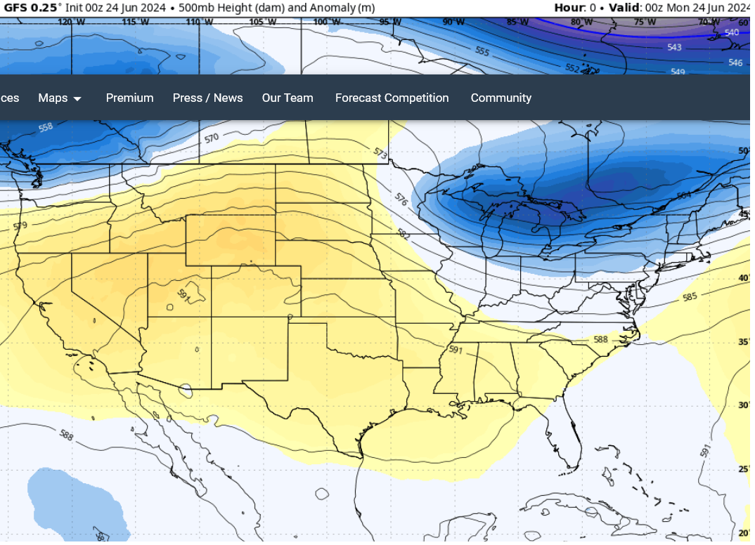
I could see that, up at the 500 mb level, the core of the “Heat Dome” was slumping all the way to Texas, as a zonal flow rocketed a fast-moving and very-positively-tilted trof through New England.
This trof brought the warm air slamming back north, to battle “cold air damming”, which involves the fact it can be difficult to dislodge the coolness maritime sea-breezes settled over New England. This occurs because the mountains and hills to our west lift the warm air, and then the warm air has a hard time sinking down and digging out the cold air. I have seen occasions when you can look up and see clouds rushing north with speed, not very far up over head, but down at the surface it remains cold and calm.
This morning it was difficult to see much of anything. The maritime air was reluctant to move, and the onrush of humid air created dense fog. The temperature was 58 and the dewpoint was 58. The temperature crept up to 62, and the dew point followed to 62. The gloomy fog grew a bit brighter.
This is actually a good defense against severe weather. If you can keep the lower levels cold and foggy, it cuts the feet from under big storms. However the computer models were creating big storms by the afternoon, and a heavy thunderstorm watch was issued.
The cool, maritime defense crumbled, starting at roughly ten o’clock, and abruptly temperatures soared, as did dew-points. By noon temperatures past 75 and dewpoints 73. It was like getting hit by a wall of mugginess. However there was still not a thunderstorm on the radar. Had the maritime air so delayed the warm-up that storm formation was prevented?
I couldn’t focus on the atmosphere, for at times I feel my wife doesn’t approve of my interest in clouds. She feels I should be more interested in grandchildren. Rather than seeking any sort of escape from children, after a week at our Childcare, she seems to double down, and to OD on children. Of course, it is different, for these are “hers”, however, even though this means they are also “mine”, there are occasions when I prefer clouds.

On this occasion it wasn’t the chubby, smaller grandchildren, but a ten-year-old granddaughter with a ten-year-old niece. They have become slender, and bound about the house like gazelles, although I don’t think gazelles talk so much. My wife was taking them out to the movies, but getting ready involved argument. I won’t bore you with the details. In the end they all drove off, and quiet descended with the weight of the humidity and heat.
I went out to study the sky, and see how the cumulus were building. One thing I like about the sky is its honesty. Where Global Warming involves a lot of politics, bias, lies and dishonesty, the sky is above such crud. Truth is simply the Truth. We may not fathom how the atmosphere works, but it is creation pure and simple, and bears the fingerprint of the Creator.
However this reminded me it was Sunday, and I was not suppose to be marveling at creation, but rather at the Creator. It’s been twelve weeks since I’ve been to church, (because my wife broke her ankle), so I attend “on line.” So I went in and clicked on the YouTube channel.
I really like the music and the pastor’s sermons, but I confess it is not the same as actually “being there”. Even Atheists note a live rock concert has something a studio album lacks. When you are “there” you are not merely part of the entirety, but you can sense a certain electricity in the air. It is indescribable, but I like it and in some ways need it.
Perhaps this explains why I’ve always been fond of thunderstorms, even the ones that scare my socks off. There is an electricity in the air.
After virtual church I checked the radar and noted showers were starting to pop up, but when I checked the “lightning map” I saw no electricity. So I tried to be cheerful about it. God was displaying his mercy, by protecting me from the mess a big thunderstorm can make. When I was young a mess made me money, as I was hired to clean things up, but now I’m old and need no extra work, for I’m huffing and puffing just feeding the chickens. So it was a good thing that the “Storm Prediction Center” was wrong, and no big storms were developing.
I made myself a Dagwood for lunch, and then lay down to digest, checking the lightning map, and saw a shower out in NY State was starting to show a few bolts.
After a Sunday Siesta I checked again, and saw that storm had gone berserk. The lightning map was showing bolts like crazy.
Lightning maps are a great addition to Doppler radar. The one I like to use is this one:
https://www.lightningmaps.org/
It produces a map which allows you to zoom out and seen an entire continent, or zoom in and see an individual thunderstorm cell. For example, here is a cell in eastern Iowa as I write:

The most recent bolts are indicated by the yellow dot surrounded by red, and a gray circle expands from the strike, showing the sound of thunder moving at roughly 750 mph away from the strike. The record of the strike is kept for an hour, changing color from yellow to orange to red as it ages. This gives you an idea of where the strikes are moving.
Originally people thought Doplar radar would allow us to track thunderstorms like hurricanes, but it was soon seen they can be far more complex. Individual cells can bubble up and dissipate, so rapidly they are like boiling water, and impossible to track. However on occasion a “complex” of storms can develop, and evolve an identity which can be tracked. The storm I now watched, while nothing like the super-cells that develop out west, did have a vigor seldom seen in New Hampshire.
For one thing, as the storm moved into southern Vermont it took on a shape like a comma, on the Doplar Radar, and this can mean you should watch out for tornadoes. For another thing, the lightning was far more frequent than normal.
Usually we have to wait between bolts, and between grumbles of thunder. The lightning map showed this storm was producing between 15 and 30 bolts a minutes. Some bolts seemed to hit between 3 and 8 places all at once, but may have been a rapid-fire flicker of lightning containing 3 to 8 bolts.
I used the “animation” feature of the Doppler to see how the storm had been developing and how it was moving. It looked likely to arrive just to our north in roughly 90 minutes, but I didn’t trust the tail of the comma-shape. I’ve seen such tails expand and even stir up separate storms. The can reach out and take a swipe at us even when storms seem sure to pass to our north. To play it safe, I decided to feed the chickens, rabbit and goat early.
It was good to get out and away from the computer screen. Not that I didn’t bring along my cell phone, to check the Doppler and the lightning map from time to time, but such adjunct information cannot match “being there.” That is why such importance was given to on-the-scene reporters, back in the day when news was more than propaganda. I find it refreshing to be the on-the-scene reporter for my own life, for I note what the computer misses. The Doppler cannot “see” even the most threatening cloud, until it sheds rain, and I’ve noticed the lightning maps miss many sky-to-sky bolts. It always pays to get out and sniff the winds myself.
As I pottered about feeding the animals I noticed none of them seemed especially concerned. The sky was bright overhead; only to the northwest was there any threatening purple. The wind was refreshing and very confused, rushing first one way and then another. “Variable” fails to describe the energy. The primary noise was the wind in the trees, but behind that rushing was the grumbling of thunder, gradually becoming louder. It was not grumbles with pauses between each rumble, but rather a steady, non-stop growl. I could deduce someone, far away, was getting their butt kicked by one whopper of a storm, without even a pause between the flashes and thunder.
Right at this point my cellphone made the horrible noise it makes when either a child has been abducted, or there is a weather alert. When I looked at it, it produced a message in Spanish. I could figure out the word “tornado” but not much else.
I sighed, and tried to see the bright side. It is very nice the weather bureau has proven it is politically correct by not favoring English-speakers. Never mind that is most of New Hampshire. We English-speakers must be patient in the dire emergency, and wait our turn.
When the message appeared in English, it informed me a tornado was imminent and I should immediately seek refuge in my cellar.
This displays a glitch in our system. The tornado may be an F-0 moving down Main Street in Keane, but the warning does not just go to the people affected. The entire region gets the message, even if the people receiving the message are many miles out of harm’s way.
This can be concerning, if we are experiencing an actual storm, but in this case it was so obvious the storm was many miles away I didn’t get a single text from a concerned friend, asking me if they should flee to their cellar. I ignored the weather-alert to attend to a realer hazard: Potato bugs. I stayed out in the warm wind and did the yucky job of squishing bugs, listening as the constant rumbling moved north of us and missed us.
As time passed I could tell the storm had past its peak, though it remained strong. When I checked the Doppler I could see it was just a summer thunderstorm, crossing the state to hit the northern suburbs of Manchester on its way to the seacoast.
As I squatted in my potato patch I noted some of the breezes were not as hot and humid. A definate break to the heat wave was coming, and by morning it had swept down the east coast and giving the big cities a delightful (brief) break to their torrid conditions.

The delightfully cool breezes to some degree mystify me. If you look at the above map you can see the polar front remains stuck up by Hudson Bay and Labrador. So where does the cold air come from? I suppose it comes from “aloft”, as an upper air trof tends to have much cooler air aloft than a “heat dome.” But the media makes no attempt to explain “mixing” and the wonders of the atmosphere, and instead rushes off to talk of the heat in Texas. They go from alarm to alarm and from panic to panic, and never sound the “all clear” to the people they leave behind.
This is especially cruel to the obedient democrats who do what they are told to do, and who ignore on-the-scene reporters like myself. When their cell phones told them to go to their cellars, they complied. Now they are still sitting down there, because their cell phones never told them to come out. (Some are likely still wearing masks.)
