
Though the “heat dome” persists, (as does the media hype), we got a break up in our hills. A cold front sagged just far enough south to shift our winds from west to east, and cool maritime air from the Gulf of Maine rescued us.
The front had quite a struggle pushing south against the heat dome. Friday morning dawned muggy, with temperatures of seventy matching a dew-point of seventy. What that means is evaporation ceases; nothing you hang out on the line will dry. And the winds were still west at first, but around mid-morning I noticed the slightest breeze from the east. There was no fuss, no fanfare, no thunder. Just a delightful coolness.
I praised God, for I had to shift 200 pounds of water softener salt from my Jeep into the softener, which is down in the bowels of the old farmhouse basement. I used to tuck 40 pound bags under each arm and scamper up and down the stairs, but I’m getting too feeble for such show-off masculinity. Now I back my Jeep up a steep incline, getting dirt in the tailpipe, and remove a cellar window, and just swing the bags through the window and down into the cellar. Much easier. I should have thought of it years ago. But even that leaves me huffing and puffing, and a cool breeze was welcomed.
I have to pause between each bag to catch my breath, which gave me plenty of time to examine the sky. The low cumulus were still coming from the west, even as the winds at the surface shifted to the east. And this situation has persisted. The east winds are only in the lowest thousand feet or so of the atmosphere. The “heat dome” is still in control further up. However riding up and over the “heat dome” come complexes of storms, and the heat is further dampened by downpours and thunder. The thunder tends to switch off as the storms run into the cool maritime air, but still one hears some grumbling up high.
As the front settled south I could check my phone to see how far it had gone. It took quite a while to even reach Worchester, not far to our south, and Hartford and NYC still baked in the 90’s. However our temperature, and dew-point, slowly sank into the 60’s.
I slept better last night, with the dew-points ten degrees cooler. During the night another complex moved through, and the night was blessed with the sound of a steady summer rain. I like listening to that hush from dreamland. You can almost hear the parched landscape sighing in satisfaction, and drinking deep.
This morning found us down to 64 in a fog, which shows the dewpoint was also 64, and even Hartford seemed to to be starting to cool. NYC remained torrid, and tempertures soared to over 90 again. The front had stalled.
Another complex came around the top of the “heat dome”, and we got some steady rain around lunchtime, which suited me just fine. It gave me an excuse to stay indoors and rest, researching stuff on the web and playing with poetry and generally allowing my mind to go where it chose. I did notice that the thunder involved with the complex stayed south of us, and wondered if this meant the front was pushing further south.
When I checked the forecast I noticed the temperatures for tomorrow had been jogged upwards from 79 to 85, which intrigued me, so I sought out the more detailed analysis of the situation offered by NOAA.
Of course, it being the weekend, all the veteran weathermen had seniority and got to take the weekend off. This means the bureau is manned by younger and more inexperienced meteorologists, who can be swayed by excitement and be prone to wish-casting. I have seen occasions where the moment the veterans arrive on Monday morning a “heavy snow warning” vanishes from the forecast, replaced by a far less exciting “winter weather advisory”. Therefore I am a bit cautious about accepting the current forecast, which is exciting.
The forecast is for the heat and humidity to come slugging back north as a bulge which could cause severe weather. Southern New Hampshire is in the “moderate” range, in the map produced by the NOAA “Storms Prediction Center.” This almost never happens in New Hampshire. “Moderate risk” is usually seen out west in places where tornadoes are common. But, when I looked into the details, I noticed there is actually a 10% chance New Hampshire will see tornadoes tomorrow. The weekend shift at the weather bureau must be very excited!
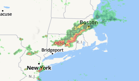
All I can say is that there is little sign of heat returning so far. Winds are still from the east and temperatures have dipped to 59. Delightful. But it does look different on the radar map, as if the next “complex” will take the shape of a warm front.
And so life goes on, on the northern edge of the dreaded “heat dome.”
SUNDAY MORNING UPDATE
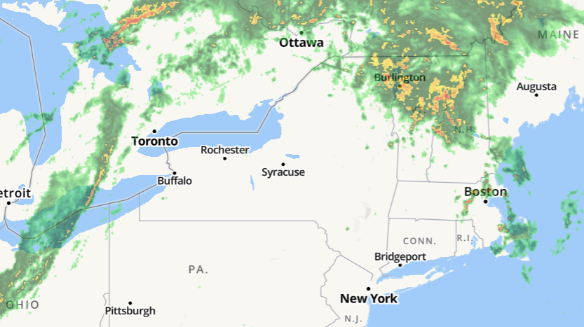
More sighing rain last night, and this morning’s radar makes it look like the warm frontal rainshield has pushed northeast of us and we’re in the warm sector.
However down at ground level the cool air is hanging tough. We have thick fog and a temperature of 59. Meanwhile, to our west on the other side of the warm sector, it is an amazing 81 at daybreak in Buffalo, as a cold front comes east over Lake Erie towards them.
I am struck by how still it is. The east wind has quit. The trees drip in the fog. Calm before a storm? (Cue suspenseful music.)

Hoping your respite is not accompanied by severe weather. I see a small area of New England could be in for some rough times today with rare enhanced chance for tornadoes.