
This is the continuation of a long series of posts, the last of which can be found at https://sunriseswansong.wordpress.com/2014/04/16/arctic-sea-ice-melt-resurrection-or-zombie/
I am finishing up a year I decided I would devote to studying the sea-ice of the arctic and, while I do not approach the expertise of the men who devote their entire lives to such study, I have learned a lot, and feel I can safely say the reporters who write the sensationalist headlines about “the vanishing ice-cap” don’t know a hundredth of what I know, and are basically fools who are talking through their hats.
Increasingly I have come to respect the actual scientists who are researching the Pole, even as I feel increasing contempt towards those researcher’s so-called “superiors,” who hold the purse strings, when all they really ought to hold is their own tongues.
The one advantage I have over the better scientists is that I don’t have to worry about losing my funding. Nobody funds me. When you’ve got nothing, you’ve got nothing to lose. Therefore I can come right out and say the idea of Man-caused Runaway Global Warming, as any sort of serious threat, is a fraud, and in some cases is a criminal fraud, which is something the better scientists cannot say without risking their livelihoods.
I pity scientists who have to work for complete jerks, and need to nod and make polite chit-chat with buffoons and bozos. It must be downright relieving to get away from such work-conditions, and only need to deal with 1600-pound polar bears, and grinding, crushing ice, and howling gales with 50 mph winds and air temperatures of thirty below. Amazingly, despite all they have to suffer through, they are gathering some data we have never had before. Just check out this wonderful buoy they are now deploying:
 (Click this image to enlarge it)
What is wonderful about these buoys is the yo-yo thermometer dangling beneath it, which allows us to measure the temperature and salinity at various levels below the ice. The stratification of arctic waters (and lack of it) is likely crucial to understanding the formation of the sea-ice, and the melting of the sea-ice as well.
In conjunction with the Argo buoys in the North Atlantic, we are entering a whole new era of understanding. It is analogous to back when we were first able to measure the upper atmosphere with weather balloons, and produce upper-atmosphere maps. Sadly, there are only 15 of these yo-yo thermometer buoys when there should be 150, (though it is risky deploying even only one of them), however half a loaf is better than none.
In these posts I’ve been using what I call my “dead reckoning” approach to the temperature, salinity and stratification of arctic waters, which is analogous to an old, Yankee farmer scratching his jaw as he gazes up at speeding cirrus, and making crafty conclusions about how the jet-stream will effect the weather, even though he doesn’t know such a thing as a jet stream exists.
However I prefer to think of myself as a farmer who deduced the existence of the jet stream, and then was thrilled when scientists proved his deductions correct.
As I confess my vanity is involved, I also wouldn’t mind learning my hunches were absurd and wildly incorrect, for I’d be learning. I’d be seeing a window open, as we are the first to see the mystery of currents at various levels under the ice. We are like Balboa, climbing the mountains of Panama and seeing a whole new vista, a whole new ocean, the Pacific, for the first time.
The scientists gleaning this data deserve our admiration, respect, and support. They should not have to endure the Bozos and Buffoons they must endure. The data they are gathering is of great value, for as we learn about how the currents shift in the arctic we are going to learn about the difference between the “cold” AMO and the “warm” AMO, and that matters to the farmers and fishermen who feed us, the shippers who provide us our goods, and the many who help us heat our homes.
Once we learn about the differences we will be better able to predict, because we will see the differences as they occur, and be able to ascertain the direction things are heading. Although these differences have little to do with “Runaway Global Warming,” they can be as vast as the differences between the Medieval Warm Period and the Little Ice Age. Because even young Boy Scouts like to “be prepared,” it would be nice to know which direction we are heading in.
The agenda-driven, political Bozos have invested hugely in the concept Global Warming is causing the icecaps to melt. I wish the icecaps actually were, because another Medieval Warm Period would be kind to humanity, however, in the short term at least, it looks like our recent warm period is ending. The AMO should shift to “cold” in around five years, and is briefly twitching to the “cold” signature even as I write. Both the long-term shift and the current twitch will lead to an increase in sea-ice, and this is likely to be highly embarrassing to the Bozos.
I fear this embarrassment, and other examples of their ineptitude, is liable to provoke public outrage and a backlash. I am afraid the good scientists will be accused of guilt-by-association. In fact the Bozos may even point at them and blame them for giving the Bozos bad advice. Politicians seldom admit their mistakes, especially when there is a chance of dumping the blame on an innocent scapegoat.
(As a historical example, Mao’s “Great Leap Forward” was a flop, but rather than accepting the blame for the flop, he instigated “The Cultural Revolution,” which made scapegoats of the professors and teachers who had always loyally supported him.)
Therefore I would like to make it very clear, as I begin this post, that the arctic scientists are the “good guys.” The Bozos and Buffoons that are these poor scientist’s so-called “superiors” are the “bad guys.”
Having made that clear, I need to announce that my self-imposed exile from the writing I most love is coming to an end. I will continue to post about sea-ice, especially as even the Alarmists expect a “recovery” this summer, and to see sea-ice decrease less. However writing about sea-ice is only a hobby, which happens because I find the scenery very beautiful, (from a distance.) What I really want to write about exposes the ugliness of Bozos from a different angle, as I describe how beautiful Truth is.
As this website starts to go through some changes, I will appreciate any feedback I receive.
(The first feedback I received was off line, from a person I greatly respect (and not my wife). I was gently told that I should be more civil, and not refer to people as “bozos.” Point taken, (though I thought “bozos” was mild and polite, compared to what was on the tip of my tongue). I’ll try to be more respectful to people I don’t respect. After all, God is in everyone, they say. I’ll try to refer to them as “the loyal opposition”, (though at times it seems they oppose the Truth).)
APRIL 29 —DMI MORNING MAPS—


VIEWS FROM NORTH POLE CAMERA ONE —Nine hours apart— 
 The pressure ridge in the left horizon will be a feature to watch, especially the larger knob, to see if it builds or settles with time.
APRIL 29 —DMI AFTERNOON MAPS—


APRIL 30 —DMI MORNING MAPS—


The Pole is actually behaving itself for a change. The textbooks always show a Polar Cell (Like Hadley and Ferrel Cells) with air decending at the Pole, creating high pressure there that flows outwards toward the boundary between the polar easterlies and the sub polar westerlies. Storms run along this boundary, generally west to east, in the textbooks.
However such a nice and neat “zonal” flow vanishes when blocking occurs and the flow becomes “meridianal.” Then all hell breaks loose: You get cross-polar flows from one side of the Pole the the other, the jet stream loops far to the south and back to the north, the media does back-flips about “the polar vortex,” and so on and so forth. Any semblance of a “Polar Cell” resembles the textbook about as much as a bug resembles a bug, after it has had a meeting with your windshield.
For the moment well-behaved and meek lows are politely moving west-to-east around the high, with an interesting low reminding me of summer as it moves along the Canadian coast, and another in northern Scandinavia, and a third over in the Bering Strait.
However at the very top of the map is Pacific trouble that is going to derange everything. It looks likely to charge north, move the wrong way along the Siberian coast, and loop up to the Pole around Sunday. A which point I’ll pick up my textbook and fling it out the window.
LOCAL VIEW —Winds finally shifting—


 “Torn” remains blocked way back to the south of Lake Superior, but as the occlusion zipped up it has kicked ahead its warm sector to the east, and nudged the high pressure ridge over us just enough to the east to start shifting the winds from northeast to southeast, and that is from sea-water that is below-normal off Nova Scotia towards sea-water that is above-normal southeast of Cape Cod.
The wind was still northeast at daybreak today, and like yesterday the temperature was 37, barely creeping up towards 40 as the morning passed. However as the afternoon has passed the low scud has started to come from the southeast, and by tomorrow the winds are likely to be south, with temperatures 25 degrees warmer, which will end the state of suspended animation our spring has been stalled in.
APRIL 30 —DMI AFTERNOON MAPS—


It is a little colder up around the Pole, and the flow continues down into the Atlantic.
A QUICK GLANCE AT UK MET MAPS —Past 24 hours— 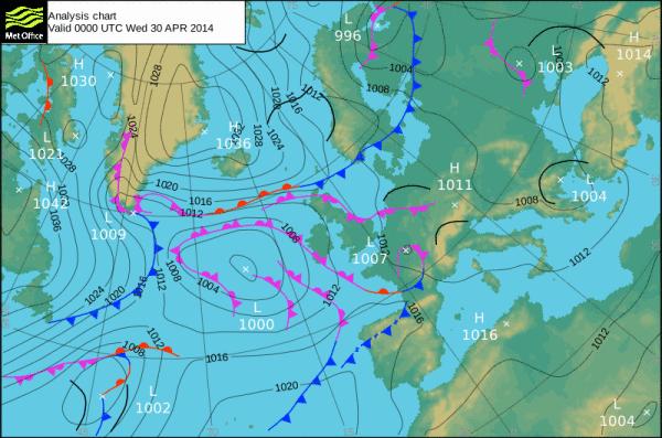 (Click these maps to enlarge them.)

The maps show the steady flow out of the arctic has pushed cooler polar air south across Scandinavia, from Iceland to Finland, but hasn’t been able to penetrate south across the British Isles. The occluded and blocked remnants of “Wendy” are drifting east towards Ireland, as “Damper” crosses the Atlantic slowly on its heels. A weak low has come along the Canadian coast and is now moving down into Baffin Bay, where a new low is forming in the weakness between the eastern extension of the blocking high pressure and the center of the block over Hudson Bay.
The block is falling apart, and the flow from west to east is resuming. The 500mb maps show a ridge of high pressure crossing the Atlantic into western Europe, as some interesting trough-activity occurs to the east of the ridge. In three days the trough will cut-ff a center briefly, over Italy, and in five days another cut-off center will form over Poland. CURRENT MAP 
MAP IN THREE DAYS
MAP IN FIVE DAYS
The passage of this ridge will finally allow some milder air to move north, in the Atlantic, though even in five days the winds look like they are still from the north in Scandinavia.
MAY 1 —DMI MORNING MAPS—


The low at the top of the map will drop down over the Pole by Sunday, as the high pressure currently over the Pole is squeezed south towards Greenland and then swept across the North Atlantic by the upper air ridge, and will be building in Scandinavia at the start of next week. The low pressure over Scandinavia will move east along the Siberian coast and then be swung north by the low over the Pole and will do a Fugiwhara dance with it.
In May we usually start to see our first pools of above-freezing air invading the Arctic Sea, but currently not even 24-hour sunshine can get it above freezing at the Pole. The sun is still relatively low.
LOCAL VIEW —May Day! May Day! May Day!— 

I can’t believe it! Despite the south wind it is once again 38 degrees ( +3 Celsius) as the wet, black night gives way to grey. The warm air has pushed as far north as the south shore of Boston and just east of Hartford, where it is in the 50’s, and up the Hudson Valley to make it 47 up in northern Vermont, but the cold hangs stubbornly in, close to the ground, and the warm front can’t push north.
Often we see this, up here. By the time the warmth finally gets here the cold front is right on its heels, and what is a two day warm spell in Virginia lasts only two hours in New Hampshire.
I’m worn out after having to attend one of those state-required adult-education classes last night, over in Keene towards the Vermont border. It was better than usual, as the teacher was my age and actually knew more than me.
It really drives me mad when the teacher is less than half my age and doesn’t know diddlesquat, yet the state requires me to pay for the class. I was in the mood to be especially sarcastic, after scraping together $3254.46 to pay my property taxes, yesterday. I don’t much like paying stupid people to waste time and money being stupid, but had the pleasant surprise of meeting someone who had a heart and years of experience.
The class was about caring for children younger than our Childcare cares for, and the wise woman admitted they really should be at home, but reality is what it is, and therefore Childcare needs to be the home they don’t have. (Infants spend longer hours at Childcare than their parents do at work.) It is upsetting to realize that in the rush of getting up and getting to work, and then collapsing after the long day, some homes don’t even offer the social experience of sitting around a table for a meal. The child learns about even such a fundamental thing at their Childcare.
It is cold, wet and grey out, and my wife is under the weather with some sort of stomach-bug. Springtime continues on hold. When it finally comes I expect it to be a mad rush.
*******
Actually, once I got the wood stove going, I noted our winds are not from the south. The smoke drifted off to the southwest, which means the wind has gone back to light airs from the northeast. The cat went out onto the porch and just sat, looking around with a sulky expression of complete disgust. Yesterday even the goats looked depressed, which is unusual when the grass is just getting green after months of being brown or snow-covered.
AND THEN THE CLOUDS ROLLED AWAY
It gradually warmed as the sky brightened, until the warm front pushed through just before noon, and then it abruptly was warm and muggy. I was absurdly overdressed, and soon absurdly hot, considering it was only up around 70 (21 Celsius). I didn’t dare complain, though I wanted to. For one thing, the trees haven’t even started to bud out, and there isn’t a lick of shade. However it looks bad if you switch from complaining about it being too cold to complaining about it being too hot in four hours. It sets a bad example for the kids.
About the only thing really green and growing is the grass, and I had the wisdom to beat the rush at the repair shop, and will be picking up my beat up, 25-year-old rider mower in the morning. I also have to think about tilling the garden, which is a bit of a swamp after the rain of the past week.
Now it is a mild evening, with heat lightning like summer’s to the south. We’ve moved from March to May so quickly my head’s spinning. Of course the map shows this is just a tiny bit of a warm sector, with the cold front on its heels. Plenty of chill to our west with the Great Lakes still 30% ice-covered, and snow in the high plains and Minnesota. And then there’s that fresh cold front dipping down in western Canada. My head may soon spin the other way.


MAY 1 —AFTERNOON DMI MAPS—


MAY 2 —DMI MORNING MAPS—


MAY 2 —DMI AFTERNOON MAPS—


MAY 3 —DMI MORNING MAPS—


I like having the DMI maps in rapid succession like this. By scrolling down you can create a sort of animation, (if your mind works like mine), and see the progression of events. What I think I’ll do is devote posts to DMI maps and nothing else, while leaving them out of this series of posts. Not only will this series become less cluttered, but the DMI maps will better tell the story of the north when there are not a lot of other distractions.
This particular series shows the polar low coming up from the Pacific. The last one came up from central Siberia, and the one before that came up from the north Atlantic. It gives you the sense the storm track is swinging around the Pole.
Just how swiftly the Pole is warming at this time of year can be seen if you compare today’s temperature map with the map from 45 days ago (March 18). (March 18 is on the left and today’s on the right.)

MAY 2 —DMI AFTERNOON MAPS—


The first above-freezing temperatures of the approaching summer are leaking through the Bering Strait, sucked behind the low I dub “Nutrak” (as it took a new track to the Pole). That mildness is “fuel” and will clash with cold air just west of Greenland, which is also being drawn north. Meanwhile the Atlantic continues to be prevented from pouring air northwards. “Damper,” south of Iceland, may change things.
“Nutrak” must be battering our polar hikers just as they get within a day’s hike of the Pole. I ought check up on them.
LARSEN AND WATERS 40 MILES FROM POLE

The above picture is from April 30, before the weather started to deteriorate. They are crossing a small pressure ridge. The North Pole Cameras are now showing grayer conditions. It’s hard to navigate without the sun.


(click images to enlarge)
The winds are picking up and the ice may be moving as fast as they can walk. Let us hope it moves them towards the Pole and not away.
They are nervous because they are apparently following in the footsteps of a large polar bear. Hopefully they wont catch up to it.
Meanwhile, to the south where the weather is both milder and sunnier, the Canada-bound “Expedition Hope” is running into much larger pressure ridges, piled up against the northern shores of Canada.

MAY 4 —DMI MORNING MAPS—


“Nutrak” is just starting to weaken, having used up his “gas.” However a new storm in the Bering Strait, (“Bear”), is going to be the next to mount a rush towards the Pole, this time coming from the Alaskan side of Bering Strait.
It looks like “Damper” south of Iceland will just sit there. The high pressure in the North Atlantic won’t budge. However it will be centered over Svalbard, and in Fram Strait the winds will push up from the south, and the ice will flow the “wrong way” for a few days. This was something that happened a lot last summer, keeping a more ice up there than in recent years. It remains to be seen whether this is a fluke event this year, or the start of a “pattern”.
MAY 4 —DMI AFTERNOON MAPS—


Wrong-way-flow in Fram Strait. “Nutrak” is weaker, “Bear” is stronger.
LARSEN AND WATERS 30 MILES FROM POLE

Explorsweb.com reports that Larsen “ and his team got a warning from Trudy Wohlleben at Canadian Ice Service about a massive open lead; 2 to 5 km wide in places. Trudy explained to the team and to ExplorersWeb that the big lead is drifting North, as the team is doing as well, with south-southwest winds ahead of an approaching storm.“
The Pole is in the lower left of this satellite view:
 (double click to fully enlarge)
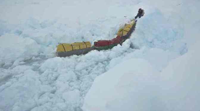
The cracks look small from outer space, but to even see them they have to be pretty wide. They can open and shut as the wind changes. I sure wouldn’t want to swim across one, but these crazy adventurers do swim across the narrow ones, wearing a “dry suit.” Here is a picture of a member of “Expedition Hope” doing exactly that, today.

Brrrrrrrrr!!!!
LOCAL VIEW —Time to plant—


I’ve been laid low so I’m laying low. I caught a mild case of the bug my wife caught, but I had the good sense to wait for the weekend, and not miss any work.
A weak clipper has come zooming down from the Canadian prairies and is keeping us cool. Even the air south of the front isn’t that warm. The real summer air is south of the front way the heck down by Cuba. There’s still ice on the Great Lakes. Click to enlarge
There may still be some ice in june: http://wattsupwiththat.com/2014/05/03/noaa-expert-lake-superior-may-have-ice-in-june/ So our west winds won’t be that warm. We need a long and steady southwest wind.
I’ve got to get to work planting cold weather stuff. I’ll probably have less time to post.
MAY 5 —DMI MORNING MAPS—


As “Bear moves towards Pole mild, above-freezing air is sucked north ahead of it.
South winds in Fram Strait, but the invading air is not especially mild or “Atlantic” yet.
MORNING PICTURES FROM THE NORTH POLE CAMERA


(Click to enlarge)
Calmer, but grey and relatively featureless. As Larsen and Waters approach the Pole they will have to rely on their GPS, as compasses wobble that far north, and there is no sunlight to get a bearing from.
I assume the dark line on the horizon is now clouds, and not open water.
SPRING IN CALGARY
Stewart Pid warned us of this, via the comments below this post. It has got to be a cold spring if even the snowmen are hitchhiking south, but it looks like the natives are handling the cold spring just fine.


MAY 5 —DMI AFTERNOON MAPS—


“Bear ” has become a decent gale north of Alaska, crunching ice the “wrong way” in the Baufort Gyre. Wrong-way winds continue in Fram Strait. The North Atlantic isn’t quite so cold as it has been. They are thawing in Svalbard.
MAY 6 —DMI MORNING MAPS—


“Bear” is likely at its height, however it likely will not weaken rapidly, and will retain strength as it creeps towards the Pole.
LARSEN AND WATERS 19 MILES FROM POLE, BUT ICE DISINTEGRATING
As we watch “Bear” creep towards the Pole it marks the fourth time the Arctic Sea has been twisted and tortured by a storm moving up towards the Pole in the past 30 days. In case you missed the past post, here is a map of the storm hitting the Pole as they struggled to put up the North Pole Camera last April 13. They had to spend a whole day just hunkered down in their tents:

These storms can crack the ice up even though it is well below the freezing point of salt water. I am afraid Eric Larsen and Ryan Waters may have skied themselves into an area that is broken up and spreading apart, judging from their last dispatch via satelite telephone: http://www.explorersweb.com/offsite/?source=http%3A%2F%2Fericlarsenexplore.com%2Fupdates%2Fjournal%2F261994&lang=en
I suppose the thing to hope for is that winds gently shift, and bring the spreading ice back together again. Gently. No crunching pressure ridges, please. And, while prayer might not be politically correct, they could use some.
At least the whiteout conditions look like they are relenting. Here’s the view from North Pole Camera Two:

This camera has drifted south, and is roughly 100 miles south of them, toward Fram Strait. It was placed on ice especially chosen because it looked stable and unlikely to crack apart, which is why it looks different from the scene Larsen and Waters are describing.
LARSEN AND WATERS RESTING JUST OVER THREE MILES FROM POLE
MAY 6 —DMI EVENING MAPS—


LARSEN AND WATERS ARRIVE AT POLE
They had to swim in “dry suits” and clamber over crunched pressure ridges, before they found some lovely flat ice for their final stroll to the Pole. Now they have to keep an eye out for polar bears, as they sit back and drift with the ice, awaiting air transport home. This is quite different from Peary, who had to walk all the way back to land. However their exploit remains a feat of amazing stamina and endurance, and amazes me.
Now, however, I expect they will feel compelled to do a bit of blathering about Global Warming. To forestall future discussion, I suppose I could drag up pictures of submarines surfacing in open leads at the North Pole in the past, even earlier in the spring. I could also point out the meridianal pattern has sent three storms up to the Pole in thirty days, and a fourth is upon them even as I speak. It is no wonder the ice is stressed, and full of leads and pressure ridges. Their journey was far more difficult than it would have been in a more quiet and zonal pattern, where the ice would have been nice and flat. They deserve credit for the prowess they displayed, overcoming a tortured icecap, but may earn themselves a debit if they prattle on too much about Global Warming.
Meanwhile the three adventurers in “Expedition Hope” are running into some pressure ridges that suggest the icecap isn’t exactly melting. In a full day’s hiking they covered only 3 km.


MAY 7 —DMI MORNING MAPS—


The storm I dubbed “Bear” is weakening as it nudges towards the Pole. While it is not as strong as the gale of April 13 it is creating a “wrong-way” flow in the Beufort Gyre, and also sucking a “wrong-way” south wind up through Fram Strait. I imagine this further crunches and tortures the ice up there.
I’m wondering what the water is like down under the ice. In the summer of 2012 there was enough slightly milder water stratified below to allow storms to churn it up and melt the ice, while in the summer of 2013 the water was seemingly colder and couldn’t melt as much. (There may still be too much ice for the wind to churn all that deeply, but I’m still wondering.)
It is still just barely cold enough for open water to be chilled, but the salt water is at roughly -1.7 degrees Celsius, and as the air warms up above -5 degrees Celsius the chilling wont be as great, and the leads will be slower to freeze over. We have a ways to go, however, before actual melting starts.
NORTH POLE CAMERA ONE AND TWO VIEWS —MAY 7, 6:00 AM—
Remember these cameras have drifted nearly down to 87 degrees north latitude, and the view is over 150 miles from what Larson and Waters are seeing at the Pole.
Is that a new crack in the Camera One shot, stretching from the central left margin to the central horizon?
(You can click these pictures to enlarge them.)


MAY 7 —DMI AFTERNOON MAPS—


OLD 1975 PICTURES OF SEA-ICE CONDITIONS
Here are some pictures taken by (or owned by) Rolf Bjornert of the Arctic Ice Dynamics Joint Experiment (AIDJEX) in 1975. The first is of setting up camp or resupplying the camp, perhaps as early as March 13, 1975, though I judge the photo to be later due to the angle of the sunshine. The aircraft are identified as “an Alaska International Airways C 130 Hercules and a USN R4-D (in civilian terms called DC-3). The second picture was taken as the ice broke up right under the feet of the scientists at the main base in September. Amazingly, they simply packed things up and moved 40 miles away and went on with their work.


This base was located on the sea ice north of Barrow Alaska. My lying eyes see the ice was solid enough to land planes on in the spring, but cracked up in the fall, which is not that different from how things are now. (However, if you are more interested in politics then science, then all Alarmists should focus on the first picture showing how strong the ice was back then, whilst all Skeptics focus on the second picture showing the ice was weak back then, and by no means include both pictures in your blog and be balanced.)
Scientists (and the military) also built bases on “ice-islands” such as the one called “T-3”. My best guess about the formation of such 100+ feet thick bergs is that they are formed by glaciers that pour ice slowly out into the Arctic Sea on the north coast of Ellesmere Island. This ice forms an ice shelf that expands during the “cold” AMO and especially during cold periods such as the Little Ice Age, and contract during the “warm” AMO and especially during warm periods such as the Medieval Warm Period. It is during warming periods that the huge “ice islands” shelve off.
I found these pictures at http://www.qsl.net/kg0yh/ice.htm
MAY 8 —DMI MORNING MAPS—


Although not all that strong, “Bear” will persist over the Pole through Saturday. Milder air is leaking north over Svalbard. The Canadian and Alaskan coast is warmer than normal as the Siberian coast is colder than normal, and some of that cold air is working back towards Finland on east winds.
An interesting one of the thousand-maps Dr, Ryan Maue makes available at the WeatherBELL site shows polar cloud cover, and that “Bear” has a weak “eye” at the center.
 (click to enlarge)
“EXPEDITION HOPE” STRUGGLES SOUTHWARDS
Besides clambering over mountainous pressure ridges, the three adventurers now must cross leads that are so choked with slush they can’t be called “ice-free.”
NOONTIME NORTH POLE CAMERA PICTURES
Camera 2 seems to show a lead to the right, with open water reflecting the light. Camera one may be showing the same crack at a greater distance. I’m not sure how far apart the two cameras are situated, though they are looking the same direction, judging from the sun. (You can click these pictures to enlarge them.)


A THIRD NORTH POLE CAMERA?
While the North Pole Environmental Observatory (NPEO) only lists two cameras at its website at http://psc.apl.washington.edu/northpole/index.html , the WUWT “Sea Ice Page” lists three at its NPEO section. http://wattsupwiththat.com/reference-pages/sea-ice-page/
I think the third just appeared today, as I never saw it there before. They may be just working out the bugs, because the picture in the archives of Camera 3 dated May 8 is dated April 14 on the picture itself, and seems to show the guys setting up the camera back then. I suppose they’ll get it all straightened out with time.

MAY 8 —DMI AFTERNOON MAPS—


QUICK PEEK AT UK MET MAPS —MAY 8—
 (Click maps to enlarge)
The whirling mess of occluded fragments of storms persists south of Iceland, though it has kicked an eastern extension into the Baltic. (I think the original storms were named “Wendy” and “Damper” with a secondary of “Torn,” “Tornson,” now appearing at the lower left.) For the most part milder Atlantic air has been prevented from moving north, though some did sneak up the east coast of Greenland and over Svalbard for a bit.
Tornson looks likely to move east across the Atlantic to England in three days, as the blocking pattern weakens for at least a while.
MAY 10 —DMI MORNING MAPS—


“Bear” is drifting off the Pole towards Eurasia. Some milder Pacific air is being drawn in through Bering Strait and along the coast of Alaska, but it is like there is a lid on the top of the North Atlantic, and no full-fledged invasions of mild air are coming north.
MAY 9 —DMI AFTERNOON MAPS—


“Bear” retains strength towards Siberia. I imagine the cloud-cover associated reflects a lot of the low sunlight, keeping the Pole cold. There are no above freezing temperatures on the Arctic Sea. We have a long way to go to reach the heat of July, when temperatures right on the arctic coastlines can top 70 degrees (21 Celsius).
NORTH POLE CAMERA PICTURES —MAY 9—


MAY 10 —DMI MORNING MAPS—


It looks like “Bear” decided against a visit to Siberia, and after visiting Severnaya Zemlya (those islands to its south) it is swinging north past the Pole towards Greenland, right over our North Pole Camera and then weakening down in Fram Strait. Winds on the Greenland side of “Bear” are quite strong, despite the weakening of the storm. While a new cross-polar-flow is suggested by isobars, from Bering Strait to Fram Strait, it looks like the winds to the north of Fram Strait will be from the west in the short term, blowing sea-ice to the east rather than south into the Strait.
Noon is at the top of the temperature map with midnight at the bottom, and you can notice day has warmed temperatures off the north coast of Alaska, as night cools temperatures off the coast of Norway.
As the high pressure block breaks down weak low pressure is forecast to drift north from the Baltic Sea to the Siberian coast east of Finland, and restart the more normal progression of lows from west to east along that coast. The storm track likely will back up across Scandinavia, and eventually Atlantic lows will ripple east to the northwest of Norway on their way to the Siberian coastline.
UK MET MAPS —May 10: Stirring the soup—

For a time storms have just been stalling out in the Atlantic, forming a confused soup of occlusions. Rather than being stirred into that soup, it looks like “Tornson” will be the first low in a long time to run along the southern edge right across the Atlantic. Because the southern edge has extended into the Baltic, “Tornson” will swing through the Baltic, and then across Finland up to the Siberian coast.
It has been a real struggle to get any warm Atlantic air up into the North Atlantic or Scandinavia. Last winter the warm front currently just touching England would have lifted warm air from the Azores right up to Norway, but now it will head east, south of Denmark, and if the warm sector doesn’t completely occlude it will only poke north to the east of the Baltic.
Ar times it seems mild air over the Black Sea has a better chance of working back to Scandinavia than air from the Azores does.
CAMERA ONE IN DANGER?

I can never recall a lead forming so close to the North Pole Camera before, especially this early in the season. (Last year the lead was in the far distance.) The the polar low “Bear” bringing strong winds to the area over this weekend, we may see the ice crack further. (What be really cool, but also dangerous to our camera, is if the two sides of the lead clapped together and started to form the jumble of ice called a “pressure ridge.”
Temperatures are well below freezing as this picture is taken. ( -10.7°C at noon yesterday.) I assume the “fog” we are seeing is actually falling snow. The buoy has drifted south of 87 degrees latitude, moving south-southeast in the steady 15 mph winds. At noon yesterday it was at 86.990°N 13.439°E, which is further east than we ever got last year.
Every year is different.
LARSEN AND WATERS FLY BACK TO RESOLUTE
The sea-ice was so broken-up at the Pole the two adventurers were lucky to find a pan large enough for the pilot to land the Twin Otter on. They were running out of food, but food could have been dropped to them if a plane couldn’t land. They are able to travel much lighter than the explorers of a hundred years ago, who had only half-completed their journey when they reached the Pole. After the plane picks them up they cross, in a matter of minutes, the miles it took days to cross as they fought their way north. Of interest to me was Ryan Water’s comment, as he looked down upon the Arctic Sea, “Flying over the area we were amazed at how broken up and crazy the surrounding area was with broken small pans and tons of leads all around.“
The leads will absorb more sunshine in the summer, but currently are allowing the water to lose heat to the cold air. I hope they took some pictures of the ice they flew over. They mentioned no pressure ridges, which I am most curious about. Also I’m curious about how much ice can grow on the new leads, and whether the ice is whitened by the snow associated with “Bear.”
“Expedition Hope” heard the plane pass over, and knew Waters and Larsen were going where it is safe and warm, as they struggle to cross pressure ridges like mountain ranges separated by leads choked with ice.
Bernice Notenboom descibes it like this: “The new leads that are developing are running east- west so on our way south we cross many of those new leads.The last one of today around 6 pm provided us with a real challenge. It was under pressure and just like plate tectonics through friction, ice blocks and rubble will start to move, collide and crumble or pile up. In awe we stood on top of this ridge and watched the other side go by, or was it our side? This movement is all caused by the strong southwest winds we are experiencing for the last week. In the lead itself emerged a massive ice block that rotated when it came in contact with water. Because there was no snow attached to it it must have come from the deep abyss of the ocean. What a spectacle it was. Now we could see hoe tons of ice ends on top of a ridge.by it simply getting pushed up there by power and with the next pressure, it may fall in the lead and disappear in the arctic. It was also our only chance to cross to the other side and we have to be very quick to operate on moving ice. We dragged the sleds across first and then we jumped from the moving ice to another shore that was slowly moving. It felt like jumping from a moving train to another.“
You can access their blog site here, though I warn you it contains a lot of Global Warming political blather: http://en.expedition-hope.org/blog/category/blog/
If you go to the “Blog” tab at the top you can access Bernice’s running comments, as well as the comments of Eric Phillips and Martin R. Hartley, who struggle south beside her. Their first-hand accounts of crossing some of the thickest ice seen in recent years seems to belie the talk of the Pole melting.

CAMERA 2 PICTURE —New Vocabulary: “Sastrugi”—

“Sastrugi” are the long straight drifts that form over the arctic sea-ice when the wind stays in one direction for a period of time. Adventurers prefer to ski with them and not across them. One interesting thing about their formation is that besides drifting ice it involves drifting salt.
I remember, when I skated on black ice that formed on the salt water of the Harreseeket River in Main back in the late 1970’s, you would see white powder drifting across the smooth surface of the ice. Curious, I dipped my index finger into a tiny drift and tasted it, and realized it was salt. When salt water freezes the salt gets extruded. You might think the salt would melt the ice, but below a certain temperature its power to melt is lost. As temperatures rise and fall the salt goes from having the power to melt to losing the power to melt, and then back again, and one result is these starchy, glued-in-place snow drifts called “Sastrugi.”
The above picture was taken roughly six hours after the Camera One picture further above. Looks like the weather is clearing, even as “Bear” approaches.
MAY 10 —DMI AFTERNOON MAPS—


NORTH POLE CAMERA 1 —NOON MAY 10—

NORTH POLE CAMERA 1 —6:00 pm MAY 10—

The lead of open water to the left looks like it either closed, or else froze over and was dusted by snow.
NORTH POLE CAMERA 2 —MIDNIGHT MAY 11—

MAY 11 —DMI MORNING MAPS—


“Bear” has proven surprisingly tough, but at long last looks like it is weakening and become a mere part of a greater area of low pressure brewing in the Baltic. Two lows will come out of the Baltic over the next week, sliding along the Russia-Finland border and then rolling east along the Siberian coast. The first is pretty much home grown, and I’ll dub it “Balt,” but the second is in part “Tornson,” (though perhaps a secondary of Tornson.)
Above freezing temperatures at noontime are oozing in through Bering Strait, and part of a Pacific-to-Atlantic cross-polar-flow.
MORNING CAMERA ONE PICTURE

The lead to the right has clearly frozen over and been dusted by snow.
NOONTIME CAMERA TWO PICTURE —May 11—

The drifts are shifting. Obviously it has been windy and well below freezing.
MAY 11 —DMI AFTERNOON MAPS—


Isobars indicate north winds in the North Atlantic. Little warmth coming up from the south on the Atlantic side. Even the surface water is being shunted south.
Results from Buoy 2013G: indicate temperatures of -2.39 C and results from Buoy 2014B: show a temperature of -2.78 C, over towards Alaska in the Beaufort Sea. These are the mildest readings I could find.
CAMERA ONE AND TWO SEE GRAY DAY AS NOON APPROACHES


You can’t really call it “a midnight sun” at noon, especially when the remains of “Bear” make things this gray and cloudy. However you can see it never gets dark, even though our cameras had already drifted down to 86.779°N, 11.654°E at noon today. Temperatures rose as high as -8.8°C at 1500z yesterday, but then dropped back down to -11.2°C at 0900z today. I suppose it can’t warm much if the sun doesn’t shine, unless the wind is strong from the south. There seems to be a strong breeze of 18 mph from the north.
LOCAL VIEW —The reluctant spring—-
While they’ve had a heat wave to our south, with temperatures as high as 85 reaching up into Pennsylvania, the warm and muggy air has had a really hard time getting up here to New Hampshire. Here’s some recent maps: (Click to enlarge)
The first map shows May 5, right after a shot of cold air pushed south a week ago, (the same air that gave snow to Calgary), so I figured we’d have a cool day or two before the high to our south started to swing warmer air up its west side. And it did start to do that, hitting somewhere out west and delighting the Global Warming crowd, as in one place it was the earliest it ever hit 100. But the heat didn’t hurry north.

The next map shows the situation three days later, on May 8. We have had decent weather, with the high sun warming us up nicely in the middle of the day, but then, as soon as the sun got low, temperatures would plummet. It would get up around 70 (21 Celsius) in the mid afternoon, but be back around 38 (3 Celsius) by the next dawn. It reminded me of when I lived in the desert at 7000 feet. You needed to have a jacket for the moment the sun dipped below the horizon. I had a real yearning for a warm night, and watched eagerly as the warm front came to Pennsylvania, (and it snowed further west, where they’d been so warm a few days before.)

The next map is from May 9, and you’ll notice the front is still stuck in Pennsylvania. What’s move, the winds in front of the front are from the east, off the cold Atlantic. It is grey and gloomy and, rather than temperatures springing upwards in the bright sunshine like a desert’s, they sulked in the upper 40’s (9 Celsius) at the warmest part of the day, before cowering back to 40 after dark.

The next map is from May 10, and surprise, surprise. The front is still stuck in Pennsylvania. However the wind swung around to the southeast and then south during the day, and abruptly it was muggy and warm, and thunderstorms rolled by ten miles to our south, (where the front “officially” made it to, on a later map, though the air sure felt like the warm front made it past us, for an afternoon at least.

And then the cold front pushed through, giving us today’s map, which is similar to the map back on May 5, though the air is not quite as cold. Once again cold air is charging south in the west. (It is snowing in Denver.) Once again a surge of warm air is rushing north in the middle of the USA. Once again a warm front is setting up to our south, but I’m distrustful and bitter. My cynicsm mutters that if any warmth gets up here it will last around three hours.

A discussion was going on during an “open thread” at the Watts Up With That site today, where people were very focused on how to read a thermometer correctly, and whether the adjustments made by people such as James Hansen were correct and/or necessary. My contribution was this comment:
Simply looking at my back porch thermometer I usually see the coldest temperatures just at dawn, however when it is clear at sunset and cloudy at dawn, especially when a warm front is approaching, the coldest temperature may be right after sunset, which is “yesterday” and not “today.” If I use the overnight low to determine “today’s” mean temperature in such a case, my numbers are not fully accurate.
A further problem is that there are all sorts of other things that can screw up my measure of how cold or warm it has been. This past winter I noticed the warm sector of storms might pass over in a matter of a few hours, spiking temperatures up with the warm front and crashing them down with the cold front, yet on one occasion, because it happened between ten PM and two AM, it straddled midnight, and therefore a warmth that lasted only 4 hours gave me my high temperatures for two days. 4 hours of mild breezes trumped 44 hours of bone-chilling cold, or at least altered the mean upwards.
What it didn’t alter was the frozen slush on my driveway. Because the warm sector only lasted, in one case, 90 minutes, the ice really didn’t have time to thaw before it was freezing again. That frozen slush, with an IQ of zero, knew something that I, with all the data from my back porch thermometer, didn’t.
This was particularly obvious last winter because warm-sectors had a hard time budging the cold air over New Hampshire, and when they finally rushed past a cold front usually was right on their heels. When this happened fifteen times during the course of a winter it meant there were fifteen occasions when my back-porch mean temperatures were uplifted, even as the frozen slush on my driveway told me it had stayed cold.
There are times when the official statistics tell me one thing, but my frozen farm pond, or the refusal of trees to bud in the spring, and many other things I witness outdoors and call “signs”, are telling me something quite different. What should I trust? Numbers on a sheet of paper? Or the reality I am amidst?
What should I be concerned more about? A 0.05 degree adjustment some geek sneaks into a spreadsheet? Or a cold west wind from still-frozen Great Lakes?
No one picked up my idea, and instead the discussion remained about how to read a thermometer, but I really have noticed a difference in the trees this spring. I can never remember them being so slow to bud, and then, when they do bloom, the blooms seem sort of withered and limp. Spring isn’t “busting out” like it usually does, Also there is a definite and very regional difference in the time things start budding.
The farm is less than a mile away, and only a hundred feet (at most) higher than my house, but more exposed to north winds, as my house is tucked into a sheltering hillside and faces southeast. The maples are just blooming at the farm, while the leaves are coming out here.
Another odd thing I noticed was that a single top bough of an oak was starting to open its buds at the farm, a hundred feet from a maple that was also just budding. Usually oaks are two weeks later than maples.
On may 9-10, 1977 there was a freak snowstorm here and down in Massachusetts that I remember well, because, when I went back to my boyhood neighborhood, many of the trees I climbed and built tree-houses in as a boy (and therefore was particularly fond of), had lost important branches, and in one case all of its branches. The tree damage was so severe because the leaves were all the way out in 1977. Not so this year.
I can’t help but wonder if the trees know something I don’t.
On his site at WeatherBELL Joe D’Aleo explained one reason warm air has trouble getting up to New England is because the Atlantic and Great Lakes and Hudson Bay still remember winter’s chill. (These waters are the same waters that remember summer’s warmth in October, and protect us from the worst Arctic Blasts right through November.) This year the spring-chilling-effect is particularly pronounced, as the Great Lakes are so late to thaw, Hudson Bay is still frozen, and there is still snow-cover to our north in Canada. (Once you get north of Cape Cod, the Atlantic’s waters are colder than normal as well.)

ANOTHER ADVENTURER CALLS IT QUITS
Posted: May 11, 2014 03:50 pm EDT
(By Correne Coetzer) Solo Norwegian skier, Bengt Rotmo has opted for an evacuation from the ice as Kenn Borek Air has decided to close down the season’s flights over the Arctic Ocean on May 12, his home team manager, Lars Ebbesen, told ExplorersWeb.
After guiding two Last Degree expeditions (110 km each), Bengt started skiing the 780 km route from the Geographic North Pole south to Canada on April 21. Lars explains about the weather and drift, “Since he started the wind and weather have not been favorable, the wind has gone the wrong way and the drift has been very strong east and backwards. Since he started his last ‘last degree’ the drift was north. He has (probably) done the 15-20km planned for, but the drift has reduced that to 5-15km instead of getting some 2-3 (to 10) km bonus drift a day.”
Ebbesen added, after the decision was made yesterday, ironicaly the drift changed and Bengt gained a few miles during the night.
[Ed note: usually the Arctic Ocean’s drift is mostly south, so the skiers skiing from the Pole to Land are the ones who benefit. This year continues strong winds pushed the ice in a northeast direction.]
The past two days Bengt had the worst weather since the start. Yesterday he had to stop early as he was worried if he would be able to get his tent up. Today he stopped to wait for better conditions. Closer to land more bad ice and open water awaits and therefore he wants to play safe and get off the ice.
ExplorersWeb is still waiting for a response from Eric Philips, Bernice Notenboom and Martin Hartley, and their home team about what they have decided.
Meanwhile, Ryan Waters and Eric Larsen, who has successfully completed the full route from Canada to the Geographic North Pole on March 6, have flown back to Canada with Kenn Borek. After packing all night in Resolute Bay, they started flying back home to Boulder, Colorado
“EXPEDITION HOPE” ONLY CROSSES 2 km ALL DAY
Bernice Notenboom reports: We have entered the dramatic zone that the Canadian Arctic Survey calls “trouble”.
Did only 2 km today through wicked yet spectacular ice fields and frozen leads that will last 10 km. We are camped in the middle of it now and spend the rest of the day filming pulling sleds in the pressure ridges. The sky cleared, wind stopped and the sun poked through.We climbed on top of an iceberg and saw for the first time the incredible anarchy of ice blocks all around us. The horizon is filled with blue ice and black reflections of leads. Incredible to see, scary to have to go through.

More at : http://www.explorersweb.com/offsite/?source=http%3A%2F%2Fen.expedition-hope.org%2Fblog%2Fpicture-of-yhe-day%2F&lang=en
I get the feeling the ice is being blown away from the north coast of Canada. This would create open areas of water between mountainous pressure ridges, which is what they describe. Judging from their map, they are still a long way from their goal. They may have problems finding a place for a plane to land, in that jumble of ice, if they get closer to Canada. (It is humorous how they portray so much of the Arctic Ocean as ice-free on their map, when it is currently ice-covered.)

MAY 12 —DMI MORNING MAPS—


MAY 12 —DMI AFTERNOON MAPS—


“Bear” is being absorbed by “Balt”, which is drifting east along the shores of the Kara Sea. A weak low is developing towards Alaska from the Pole, and drifting towards Baffin Bay, (and making things uncomfortable for the three adventurers in “Expedition Hope”). For a while weak lows will drift around a vauge center of high pressure over the Pole, however it is already looking like “Balt” will be followed out of the Baltic Sea by “Tornson,” and they may combine to generate a decent storm over the Laptev Sea over the weekend, and push yet another storm up over the Pole by the middle of next week. Of course, thats a long ways away, and one can’t trust computer models that far into the mists of the future.
High pressure over Canada is drawing mild air north over Alaska, and Buoy 2013F: is currently reporting +0.02°C, which is our first hint of the summer thaw. (Some other buoys reported above freezing temperatures earlier over there. Here is a map of how Buoy 2013F has been drifting, followed by a rather dull picture of what it is currently viewing.
 click to enlarge

Similar dull views are seen by the North Pole Camera across the Pole:
NORTH POLE CAMERA PICTURES


You can click these pictures to enlarge them, or on some computers you can right-click them and open them to a new tab, which keeps you from losing your spot in my fascinating text.
These buoys have drifted down to 86.698°N, 10.544°E as temperatures have risen to -8.6°C, which is roughly normal for this time of year. I’m not sure this much cloud cover is normal. I’m wondering how much the clouds protect the ice, and especially any open water, from warming.
“EXPEDITION HOPE” LOSES HOPE

I am really going to miss the superb photographs this trio has been sending back from the Pole, however the pilot who is suppose to fly them out has pretty much made up the young adventurer’s minds for them. He has flow to and fro over the ice all spring, and knows how smashed and bashed up it is. Also, (though no one has said this,) there has been more snow than usual, and can snow can hide weaknesses in the ice and make an unsafe floe of ice look safe. Lastly, the further south this trio proceeds the more jumbled and cracked the ice is likely to get, and safe “pans” of ice are likely to become fewer and farther between. In any case, the pilot has drawn the line, and stated he will not land on the ice in June as he has done in the past, and in fact will make his last landing today, on May 12, weather permitting.
I imagine he’ll break his own rule, as the weather isn’t permitting a landing today. However “Expedition Hope” has no hope of reaching Canada on foot. They may give us a few more good photographs, as they head south waiting for the weather to improve. For the pilot’s sake, I hope they find a good, flat stretch of ice and stay there, and for their own sake I hope they don’t try anything too foolish. They also could likely use the prayers of those so inclined.
The best thing these crazy young whippersnappers do is to give us a far clearer picture of the situation up there than the static cameras can do. Of course, Alarmists and Skeptics are perfectly capable of looking at the same picture and arriving at vastly different conclusions, but at least we have these pictures, which brings light to the subject.
That’s the cue for the end of this post. It will be continued at: https://sunriseswansong.wordpress.com/2014/05/12/arctic-sea-ice-melt-the-pulverized-pole/

Cheer up Caleb it could be worse … a lot worse! Check out Calgary’s forecast as things go to hell in a hurry starting this evening. Beautiful out now at 20C.
http://www.theweathernetwork.com/weather/canada/alberta/calgary
Might I suggest obsessive-compulsive alarmists or even psychopathic obsessive-compulsive alarmists 😉 if you aren’t allowed Bozos.
Don’t forget the other side started the name calling with the denier label.
You are going to get me in trouble!
You are quite correct, of course. I first got slammed back in 2007, and was stunned when I was called a “ditto-head” for mentioning something I’d seen on the Climate Audit site. (Only later did I figure out Rush Limbaugh had mention Steve McIntyre’s website on his radio show, accidentally causing the site to get such an overload it crashed. It was while Climate Audit was “off the air” that I discovered Watts Up With That.)
The neat thing about Steve McIntyre is that he remains diplomatic even as he persists, and courteous even as he insists. I’m too hot-headed, and need to govern my tongue and be more like Steve.
However I am what I am. Maybe when I’m seventy I’ll become more dignified.
By the way, that cold air that hit you up in Calgary a couple of days ago has wasted no time, and is charging down across New England this afternoon.
Excellent find on the Calgary photos. Today is starting out decent and that is good since 5 days straight of snow in May is crazy even for this place. Farmers will have a tough time this year of mother nature doesn’t soon cut them some slack.
Enjoying your posts … keep up the good work.
I’m glad you liked those pictures. I chose them with you in mind.
Five days of snow in May! Sheesh! I’ll bet people’s sense of humor was running out.
The northern growing season is going to be dangerously short, it seems. Our maples are only starting to bloom and haven’t leafed out. Today I was planting russet Burbank potatoes, wondering how small they’d be at harvest, as they like a full 150 days to get really big, and 150 days will be October 7 and it seems they’ll get frosted before then.
O well. I’ll soak up what summer there is like a sponge.